5 McKinney Falls State Park: Homestead Trail
The walk to get to the trailhead is a miniadventure. Go over the lavalike rock flows from Pilot Knob volcano, which created Lower McKinney Falls eighty million years ago. Then ford Onion Creek, or wade across the top of the falls. The trail passes by the ruins of Thomas F. McKinney’s 1850s homestead and grist mill. Return to the trailhead and walk to the Smith Rock Shelter Trail to view the remnants of a natural rock shelter used hundreds of years ago.
Distance: 3-mile loop
Approximate hiking time: 1.5 hours
Trail surface: Dirt path with some limestone outcrops
Best season: September to June
Other trail users: Mountain bikers, joggers, dog walkers
Canine compatibility: Leashed dogs permitted
Land status: State park; Texas Parks & Wildlife Department
Fees and permits: Day-use fee (or use the State Parks Pass)
Schedule: 8:00 a.m. to 10:00 p.m. daily
Maps: Trail maps are available in the park office. You can also find maps on the Web site www.tpwd.state.tx.us. NCGS topo: Montopolis, 7.5' quad
Trail contacts: McKinney Falls State Park, 5808 McKinney Falls Pkwy., Austin 78744; (512) 243-1643
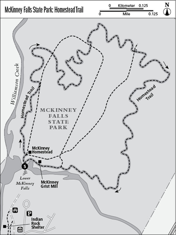
Finding the trailhead: From Austin, head south on US 183, passing the junctions with US 290 and TX 71. After passing TX 71, Austin-Bergstrom Airport is on the left (east). McKinney Falls Parkway is on the right (west). There is a brown state park sign that marks the turn. McKinney Falls State Park is about 3 miles from the turn, on the right (north). Enter the park and drive to the park headquarters. Leave the headquarters and take a right, following the park road. Turn right to the Lower McKinney Falls parking area. From here, walk down to the creek and waterfall area. After crossing Onion Creek at the Lower Falls, the trailhead is to the right and marked HOMESTEAD TRAIL. DeLorme: Texas Atlas & Gazetteer: Page 69 G11. GPS: N30 11.172' / W97 43.26'
The Hike
To start, head left from the parking area, following the northern section of the loop. The trail follows portions of Williamson Creek and Onion Creek; both are important wildlife corridors. Water snakes, including venomous water moccasins, may be near the water’s edge. Be careful.
Bear left toward the remains of the Thomas F. McKinney two-story home. The park is named after McKinney, who settled here in the 1850s and was one of the original 300 colonists in Stephen F. Austin’s early-nineteenth-century settlement. Follow the trail as it makes a few turns and then runs parallel with Williamson Creek. Bald cypress, sycamore, buttonbush, and willow trees line the creek bank. The trail is narrow but easy to follow and has thick undergrowth at the edges, where poison ivy can be abundant. Bend hard right, going south and away from the creek. The Texas Parks & Wildlife Department’s headquarters complex can be seen to the left.
Watch for large spider webs woven across the path by orb weavers, a common garden spider. In the summer the throaty sound of “chic-breee” may be heard. This is the call of the summer tanager, the only entirely red bird in North America. The park is located at the junction of the Edwards Plateau and the blackland prairie, with the resulting mixed habitats, and is home to 224 species of birds and many mammals. Follow the trail down and across a dry wash and through a large stand of oaks, where the trail crosses a long open stretch of bedrock. Sometimes the limestone forms a stair-stepping topography with sharp drop-offs to the creek.
The stabilized remains of the McKinney grist mill now come into view. This was the first mill in the area and was a major contributor to the economy.
In August great egrets can be seen roosting high in the cypress trees, while great blue herons feed along the creek banks. The terrain leading to Lower Falls was formed eighty million years ago by the eruptions of Pilot Knob volcano. Backtrack across the Lower Falls and the limestone moonscape back to the parking lot.
After the hike, enjoy the picnic area along Onion Creek. Visit the Smith Rock Shelter Trail, where Native Americans roamed hundreds of years ago. The 3.5-mile Onion Creek Hike and Bike Trail loop is also in the park and is wheelchair accessible. The park, although located only 13 miles south of Austin, retains a rustic, out-in-the-woods atmosphere.
Miles and Directions
0.0Start the Homestead Trail after crossing Onion Creek, then continue to the left, heading north.
0.4Reach the McKinney Homestead, which is partly hidden by trees. Williamson Creek is on the left (west) and the park maintenance road is on the right (east), but it cannot be seen from the trail.
1.1Cross the park maintenance road and continue heading east.
1.3Cross the park maintenance road heading north, and then the trail twists and turns and veers sharply right, heading east.
1.5Go past the park maintenance road junction on the right and continue heading east.
2.3Veer hard right, heading south.
2.8Reach the remains of the McKinney grist mill. Continue past the mill back to the trailhead and cross the Lower Falls.
3.0Arrive back at the parking area.