6 Circle C Ranch: Slaughter Creek
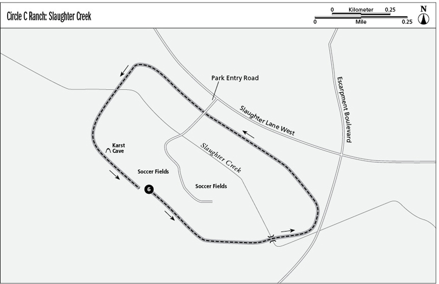
Interest is added to the hike as it passes by a fenced area that protects a karst cave. A karst is an underground area of eroded limestone, caves, and streams, and the karst under central Texas allows groundwater to flow into the Edwards Aquifer. Cross Slaughter Creek twice, once over a concrete path and the second time by using rocks as stepping stones. The loop around the soccer fields is an easy hike that’s good for families with young children.
Distance: 2.4-mile counterclockwise loop
Approximate hiking time: 1.5 hours
Trail surface: Crushed granite
Best season: Year-round
Other trail users: Dog walkers, joggers, bikers, parents with strollers
Canine compatibility: Leashed dogs permitted
Land status: Metro park; City of Austin Parks Department
Fees and permits: None
Schedule: Daily, dawn to dusk. Entrance gate is locked when the park closes.
Maps: No maps available in the park. Visit the Web site www.ci.austin.tx.us/parks/traildirectory.htm for maps. NCGS topo: Signal Hill, 7.5' quad
Trail contacts: Austin Parks and Recreation Department, 1600 City Park Rd., Austin 78730; (512) 346-3807 or (512) 974-6700
Finding the trailhead: From south Austin, take the MoPac Expressway south from William Cannon Drive for 2.5 miles. Turn right at the West Slaughter Lane exit. Go west on Slaughter Lane for less than a mile. Pass Escarpment Boulevard and watch for the park entrance at 6301 West Slaughter La. Go to the west side of the most distant parking area. Park near the restrooms and water fountain. The trailhead is directly behind the restroom building. DeLorme: Texas Atlas & Gazetteer: Page 69 G10. GPS: N30 11.975' / W97 53.215'
The Hike
Start from the southern trailhead directly behind the restroom building, near the west side of the farthest parking lot. Turn left onto the asphalt trail heading toward a soccer field and woods to the right. The trail circles around a large number of soccer fields. Follow the trail slightly southeast and continue to follow the loop left, in a counterclockwise direction.
Turn left near the path to the disc golf course, where the trail turns to packed gravel. Cedars, live oak, and other hardwood trees are about 30 feet from the trail’s edge. Mourning doves and other birds are frequently seen. The right side of the trail slopes slightly up, while the left is flat, with some low limestone outcroppings. One section of the trail has 1- to 2-foot-diameter rocks separating the path from a soccer field. Reach a Y and take the left branch, heading east.
Walk under a tunnel formed by branches of live oak trees and reach a concrete crossing over Slaughter Creek. Depending upon the amount of rainfall, the creek may be flowing or just be a dry creek bed. On the left side, to the north, the creek branches around several large oak and sycamore trees. This presents a good photo op.
Follow the trail east for a short distance, and then bear left (north). Escarpment Boulevard is to the right (east) and Slaughter Lane is straight ahead (north). Veer slightly left, heading northwest, with Slaughter Lane paralleling the trail. Pass by two concrete benches on the left, next to a disc golf “hole,” which is actually a concrete pad.
Reach an unpaved parking area near the park entrance and adjoining the park entrance road. Use caution and cross the road, heading northeast. Cedar and oak trees are about 30 feet off the trail, and depending on the season, this is a favorite section for butterflies.
Bend to the left and reach a T. Take the left branch, heading southwest. Utility lines and a fire hydrant are straight ahead. Here the trail is highly eroded and has many small rocks on it. This 100 yards is the most difficult section of the hike. The park boundary fence is to the right. Reach and cross Slaughter Creek, which may be flowing or dry depending on the amount of rain. The dry creek bed is about 35 feet wide, rough, with a limestone bottom and rocks strewn about.
Continue straight and pass a basketball court with a narrow dirt path leading to it. The trail changes to a dirt and grass path. Pass along a soccer field and turn left at the goal line, walking between woods on the right and the field on the left.
Miles and Directions
0.0Start at the southern trailhead near the main parking area and behind the restrooms. There is no marked trailhead. Turn left, heading south onto the asphalt trail.
0.1Turn left and head southeast at a disc golf pad.
0.2Continue to follow the trail, bearing left and then straight. Pass a park maintenance path on the right.
0.4Cross over a dirt road and bear left. Go straight, heading generally east.
0.5Reach a Y and take the left branch, heading east.
0.6Reach a concrete bridge crossing Slaughter Creek. Depending on the amount of rain, the creek can be a dry bed filled with rocks or a stream flowing over the concrete slab.
0.7Continue to follow the trail and cross over a 3-foot-wide gravel path. About 60 yards straight ahead is Slaughter Lane. Just before the road is a short limestone block wall.
0.8Continue to follow the trail to where it appears to dead-end. Escarpment Boulevard is to the east. Turn left where the trail restarts, heading north.
1.0Follow the trail, bearing slightly left (northwest) and with Slaughter Lane to the right (northeast).
1.1Reach a concrete section of the trail that’s about 100 feet long.
1.3Reach the park entrance road. Cross the entry road and stay on the trail, heading north. Use caution. Or follow the entrance road back to the parking area.
1.6Continue to follow the trail, generally to the left and northwest. Reach a T and take the left branch, heading southwest. There are utility lines and a fire hydrant straight ahead.
1.7The trail becomes highly eroded and rocky for about 100 yards. This is the most difficult part of the hike. Cross Slaughter Creek, which is about 35 feet wide.
1.8Continue to follow the trail, with the park boundary fence and utility lines to the right, about 8 feet away. Pass a basketball court and soccer fields. The crushed gravel trail changes to dirt.
1.9Turn left at the end of the soccer field and walk along the grass between the soccer field and the woods.
2.0Follow the trail, bearing left (southeast), and pass a high fence on the left protecting a karst cave. A soccer field abuts the fence.
2.2Bend hard left at a baseball field backstop fence and continue to follow the trail southeast.
2.3Reach the disc golf pad and backtrack to the start of the trail.
2.4Arrive back at the trailhead.