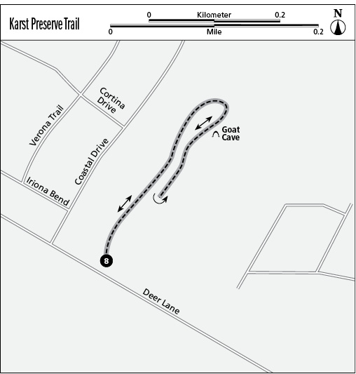
8 Goat Cave: Karst Preserve Trail
This hike, which allows you to see a small section of the underground karst world, is a great hike for young children or others interested in learning more about the Edwards Aquifer and the geology around Austin. Several small caves have been formed here by the collapse of sinkholes. Goat Cave, near the end of the hike, is home to a colony of bats. Entry is prohibited.
Distance: 0.7 mile out and back
Approximate hiking time: 0.75 hour
Trail surface: Dirt with some rock
Best season: Year-round
Other trail users: Bird-watchers
Canine compatibility: Dogs not permitted
Land status: Nature preserve; City of Austin Parks Department
Fees and permits: None
Schedule: Dawn to dusk; day use only
Maps: No maps available in the park; visit the Web site www.ci.austin.tx.us/parks/traildirectory.htm for maps. NCGS topo: Oak Hill, 7.5' quad
Trail contacts: Austin Parks and Recreation Department, 1600 City Park Rd., Austin 78730; (512) 346-3807 or (512) 974-6700
Special considerations: No bikes permitted
Finding the trailhead: From south Austin, take Capital of Texas Highway south to the Lamar Boulevard exit. Follow Lamar Boulevard for 1.4 miles to the Brodie Lane exit. Follow Brodie Lane south for 3 miles to Deer Lane. Turn right (west) onto Deer Lane; the preserve is on the right at 3900 Deer La. Park along the wide shoulder on the north side of the road at the preserve entrance. This is a public road, so be sure to take any valuables with you and lock your vehicle. DeLorme: Texas Atlas & Gazetteer: Page 69 G10. GPS: N30 11.814' / W97 50.884'
The Hike
At the trailhead, stop at the kiosk to read about karst geology and cave inhabitants, including troglobites, troglozenes, and troglophiles. Several endangered species make these caves their home. All are adapted to living in a wet, humid, constant-temperature environment, and some have no eyes. Some are so small that it is difficult to see them without using magnification. Larger animals, spiders, snakes, and bats also use the sinkholes. Karsts are formed when slightly acidic water percolates down through soluble rocks, mostly limestone, creating sinkholes and caves.
The trail is dirt, mostly shaded and flat. Live oak trees and other species cover the entire eight-acre preserve, providing ample shade. Three sinkholes—Wade Sink, Hide Out Sink, and Goat Cave—can be viewed from paths leading to them. This entire area is ecologically sensitive, so stay on the trail or paths, and do not climb on, or attempt to explore, the caves.
Start to follow the trail north, and in less than 500 feet a path leads to the left. Wade Sink is about 30 feet down the path. The hole is 8 feet by 15 feet in diameter, with rocks and slab rock around the perimeter. After carefully exploring the area, return to the main trail and turn left. Residences and Coastal Drive can be seen through the trees to the west. Almost immediately, pass another path on the left, which leads to fallen tree limbs and leaves, possibly filling in and covering a small sinkhole. Butterflies and birds, especially mourning doves, are numerous.
The trail squiggles a little to the right and left. In about 150 feet, another path heads to the left. Follow the path to reach Hide Out Sink. It is only 3 or 4 feet deep, but the rocks around it and the partially exposed limestone slab are noteworthy. The slab is a portion of the collapsed roof of the cave. Walking through the woods, with short paths leading to mysterious formations, can furnish opportunities for a great adventure for young children.
Reach a Y and follow the right branch a short distance to a bench and the fence around Goat Cave. Not much can be seen of Goat Cave due to the fence. The cave opening is about 25 feet in diameter. Continue north on the path as it gets a little rockier until it reaches the preserve boundary fence. Backtrack to the trailhead.
Miles and Directions
0.0Start at the trailhead kiosk past the berm, at the north edge of Deer Lane. Head left, going north.
0.1A narrow path on the left leads to Wade Sink, about 25 feet away. Return to the trail and follow it straight in a northeast direction.
0.2Bear slightly left, still heading northeast, and pass a path on the left leading to Hide Out Sink. Return from the sinkhole and turn left onto the trail.
0.3Reach a Y and take the right branch, still heading generally northeast. Bear slightly left and reach a wooden bench on the left and a fenced area protecting Goat Cave.
0.4Return to the main trail and continue left (forward) until reaching the park boundary fence. Backtrack from here to the trailhead.
0.7Arrive back at the trailhead and parking area.