9 Mary Moore Searight: Metro Loop Trail
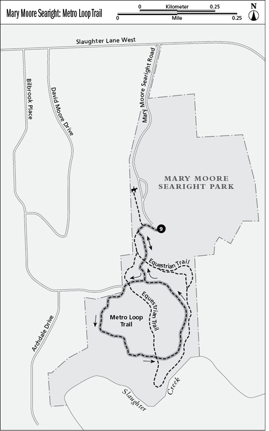
This park has a number of intersecting trails, totaling over 6 miles, which makes it easy to alter the hike depending on the time available and amount of solitude wanted. These trails can be reached from the paved Metro Loop Trail. Spanish moss drapes many of the oak trees.
Distance: 2.4-mile lollipop
Approximate hiking time: 1.5 hours
Trail surface: Dirt, asphalt
Best season: Year-round
Other trail users: Joggers, dog walkers, equestrians
Canine compatibility: Leashed dogs permitted
Land status: Metro park; City of Austin Parks Department
Fees and permits: None
Schedule: 5:00 a.m. to 10:00 p.m.
Maps: No maps available in the park; visit the Web site www.ci.austin.tx.us/parks/traildirectory.htm for maps. USGS topo: Oak Hill, 7.5' quad
Trail contacts: Austin Parks and Recreation Department, 1600 City Park Rd., Austin 78730; (512) 346-3807 or (512) 974-6700
Finding the trailhead: From south Austin, take TX 71 west to I-35. Take I-35 south for 4 miles to the Slaughter Lane exit. Follow Slaughter Lane west 1.3 miles to the park entrance, at 407 Slaughter La. The Mary Moore Searight entrance road is just past Yarsa Boulevard. Proceed about 0.7 mile on the entrance road and park at the south side near the pavilion and restrooms. There are speed bumps on the entrance road—use caution. The asphalt trail is about 50 feet west from the parking area. DeLorme: Texas Atlas & Gazetteer: Page 69 G10. GPS: N30 09.759' / W97 48.473'
The Hike
At the pavilion and restrooms on the south side of the parking lot, head west on the sidewalk for about 50 feet to reach the asphalt trail. There are large boulders on the right and cedar trees on the left. Cross a wide dry section of creek bed that has a limestone bottom. This is a picturesque hike, great for dog walkers.
Go up a slight slope to a Y intersection in the trail and take the left branch. Follow the trail, bearing slightly to the right then left, and then pass a path on the left. Many of the live oaks are festooned with strands of Spanish moss. Watch for Spanish moss in some of the cedars, as this is unusual.
The graveled Equestrian Trail crosses the Metro Loop Trail three times, giving you the opportunity to shorten or lengthen the hike. Continue heading south to a T intersection and take the right branch to the west. The trail forms a counterclockwise loop from this point and completes the loop back at this intersection. There are some prickly pear cactus and low cedars on both sides of the trail.
A path on the right leads to a road and a subdivision. There are numerous exercise stations, including a set of monkey bars and chinning bars. The 380-acre park is becoming a refuge for local wildlife as residential construction around the park destroys their habitat. Early morning or late afternoon affords the best opportunity to see raccoon, opposum, deer, and, rarely, fox.
Several dirt paths cross the trail, and playing fields can be seen on the left. Pass under utility lines and follow along them for about 75 yards. Twelve large limestone blocks (3 feet high by 3 feet wide by 8 feet long) line the right side of the trail. Some are low enough to sit on, providing a place to relax and enjoy the scenery.
Occasionally, traffic noise can be heard from Slaughter Lane to the north and I-35 to the east. This is a reminder that the hike is in the city.
Miles and Directions
0.0Start at the trailhead adjacent to the main parking area, behind the restrooms, and head south.
0.1Cross over a seasonally dry creek bed with a limestone bottom. Go up a slight slope to a Y intersection in the trail. Take the left branch, heading southeast.
0.3Continue straight ahead. A path crosses the trail from the left.
0.5Reach a T intersection and turn right, heading southwest. Pass an exercise station and bench on the right, shaded by large live oak trees.
0.7Pass a large open area on the left that contains wildflowers. Residences are in view to the right. Follow the trail slightly uphill, and then make a hard left (south).
0.8The trail bends right and left. Continue to follow the trail, passing a chinning bar on the right, and then bear left (southeast).
1.0Pass by a dozen large (3 feet high by 3 feet wide by 8 feet long) rectangular limestone rocks on the right. Bear left (east) at the end of the large rocks.
1.3Pass by a monkey bar exercise station on the right. The remains of an old barbed-wire fence go for a short distance to the right.
1.5Pass an exercise station on the left. Follow the trail basically north, as it bends back and forth to the right and left.
1.8Follow the trail as it loops to the left (northwest). There is a bench on the right, in the shade of a large live oak tree.
2.0Reach a Y in the trail and take the right branch, heading north. The left branch goes back to the loop. This area should look familiar. Backtrack to the trailhead.
2.4Arrive back at the trailhead.