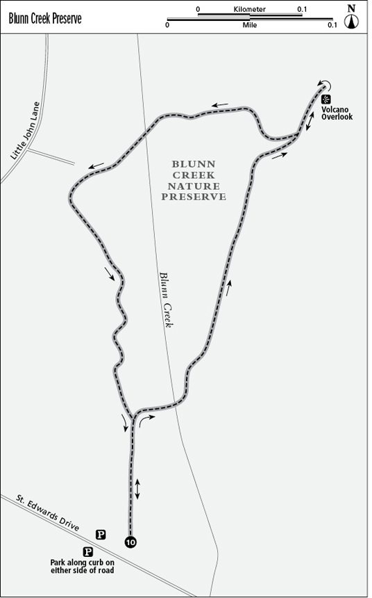
10 Blunn Creek Preserve
Forty-acre Blunn Creek Nature Preserve, across the street from St. Edward’s University, remains wild and natural. The trails are well marked and maintained, although portions are rocky and steep. Blunn Creek is forded twice while going from dense tree cover to hilly overlooks. A short out-and-back segment leads to the Volcano Overlook.
Distance: 1.5-mile counterclockwise loop
Approximate hiking time: 1 hour
Trail surface: Dirt with some rock (compressed volcanic ash)
Best season: Year-round
Other trail users: Bird-watchers
Canine compatibility: No dogs permitted
Land status: Nature preserve; City of Austin Parks Department
Fees and permits: None
Schedule: 5:00 a.m. to 10:00 p.m. daily
Maps: No maps available in the park; visit the Web site www.ci.austin.tx.us/parks/traildirectory.htm for maps. NCGS topo: Montopolis, 7.5' quad
Trail contacts: Austin Parks and Recreation Department, 1600 City Park Rd., Austin 78730; (512) 346-3807 or (512) 974-6700
Special considerations: No potable water or restroom facilities. No bikes allowed.
Finding the trailhead: From near downtown Austin, take Cesar Chavez Street to I-35. Enter I-35 and go south over the Colorado River (Town Lake) for 2 miles, then take the Oltorf Street exit to the I-35 Frontage Road. Follow the Frontage Road south for 0.5 mile and turn right (west) onto St. Edwards Drive. Go about 3 blocks to 1200 St. Edwards Dr. The preserve is on the right (north) side of the road. Park along the curb. Since this is a public road, be sure to take any valuables with you and lock your car. DeLorme: Texas Atlas & Gazetteer: Page 93 K8. GPS: N30 13.556' / W97 44.518'
The Hike
Start at the West Creek Trail trailhead, on the north side of St. Edwards Drive. This hike combines portions of several trails in the preserve, and most parallel the creek. There are many branches and intersections, but they are well marked. The trail surface is mostly dirt, with some gravel and compressed volcanic rock. Some of the outcroppings and rocks were created by volcanoes that existed in Travis County about seventy million years ago.
Within 0.1 mile, take the trail on the right (east), which is the Creek Loop. Ford Blunn Creek, which is generally less than a foot deep. It is spring fed and flows year-round, furnishing good habitat for plants and wildlife. More than one hundred species of birds have been seen in the preserve. Add a dimension to the hike by watching for lark buntings, which sometimes cluster in flocks during the fall migration. This easy to identify, small, stocky, black bird has white patches on its wings and a large, bluish-gray beak.
Reach a T and turn left, heading north toward the Volcano Overlook. This is the hardest section of the hike, going over rock outcrops for about 60 feet, including a 30-foot increase in elevation. Large groups of prickly pear cactus, the state plant, reach to the trail’s edge. At the top of the hill is the Volcano Overlook, a three-tiered section with interpretive signs and surrounded by rocks. The view, which includes St. Edward’s University to the south and the creek bottomland, where hackberry, elms, and some persimmon trees thrive, is great. The main university building sits on top of the remains of a volcano. This is a good spot to just kick back and enjoy.
Backtrack from the overlook and turn west, crossing Blunn Creek. Watch for turtles sunning themselves on logs in the creek. Animal tracks can be seen along the creek edge, including those of armadillo, fox, and skunk. Mature live oak trees, some covered with Spanish moss, are in the woods. Get on the West Creek Trail heading southeast and cross the creek. This is an easy crossing since the creek bed is solid rock. Solid limestone outcrops line the west side of the creek. The water rushing over the many rocks creates a pleasant gurgling sound. Follow the trail south back to the trailhead.
Miles and Directions
0.0Start at the West Creek Trail trailhead on the north side of St. Edwards Drive. Head directly north.
0.1Reach a trail marker post on the right and a path intersecting from the right. Turn right, heading east, onto the Creek Loop Trail.
0.2Reach a junction where the East Circle Trail joins from the right. Turn right (east) onto the East Circle Trail and cross Blunn Creek.
0.3Reach a T and a trail marker post. Take the left branch, heading north on the East Branch Trail.
0.4Bear slightly right and left, and then right, to reach a volcanic and limestone outcrop. Go up the outcrop for about 60 feet, with a 30-foot rise in elevation.
0.5Reach a T and a trail marker post. Take the right branch, heading east to the Volcanic Overlook.
0.6Reach the Volcanic Overlook, which has three levels. St. Edward's University can be seen to the southwest. Backtrack to the T and turn right, heading northwest.
0.8Reach a Y with a very large (5-foot diameter) live oak tree. Take the left branch, heading west.
0.9Follow the trail bearing left to reach Blunn Creek. The creek bed is solid flat limestone, making the crossing easy—except after a heavy rain. The trail heads up and is rough for about 40 feet.
1.0Reach a Y and continue straight, and then bend left on the trail. The next section of the trail is rough, with limestone outcrops and pebbles across the trail.
1.2 A path intersects from the right. Continue to follow the trail straight (south).
1.3Pass a trail marker post on the left, which points to the Creek Loop Trail. Continue to follow the trail straight, going
1.3Pass a trail marker post on the left, which points to the Creek Loop Trail. Continue to follow the trail straight, going south, and backtrack to the trailhead.
1.5Arrive back at the trailhead.