14 Wild Basin Wilderness Preserve
This is one of Austin’s most pristine nature preserves. The trails wind through granite outcrops, woods, and grasslands and near Bee Creek. A small waterfall about halfway through the hike is refreshing. It’s home to the black-capped vireo, a threatened species, and hundreds of other bird species. There are many interpretive stations along the trail, making it a great hike for nature lovers.
Distance: 2.1-mile counterclockwise loop of interconnecting short trails
Approximate hiking time: 2 hours (to allow time to read interpretive information)
Trail surface: Dirt, limestone
Best season: Year-round
Other trail users: Bird-watchers, student study groups
Canine compatibility: Dogs not allowed
Land status: Nature preserve; City of Austin Parks Department
Fees and permits: Voluntary day-use fee based on the honor system. (Be honorable.)
Schedule: Sunrise to sunset daily
Maps: Interpretive trail maps are available at the Environmental Education Center and at a kiosk at the trailhead. Maps are also available at the Web site www.wildbasin.org. USGS topo: Austin West, 7.5' quad
Trail contacts: Austin Parks and Recreation Department, 1600 City Park Rd., Austin 78730; (512) 346-3807 or (512) 327-7622
Special considerations: Bicycles not allowed. Picnicking not allowed. No potable water or restroom facilities on the trail. Portable toilets near the parking area. Guided tours are available.
Finding the trailhead: From near downtown Austin, take the First Street entrance onto the MoPac Expressway. Head south on MoPac for 3 miles to the Capital of Texas Highway exit. Exit onto Capital of Texas Highway and head north for 5 miles to 805 North Capital of Texas Hwy. Turn right into the entrance of Wild Basin and check in at the environmental education center. DeLorme: Texas Atlas & Gazetteer: Page 92 F5. GPS: N30 18.370' / W97 49.151'
The Hike
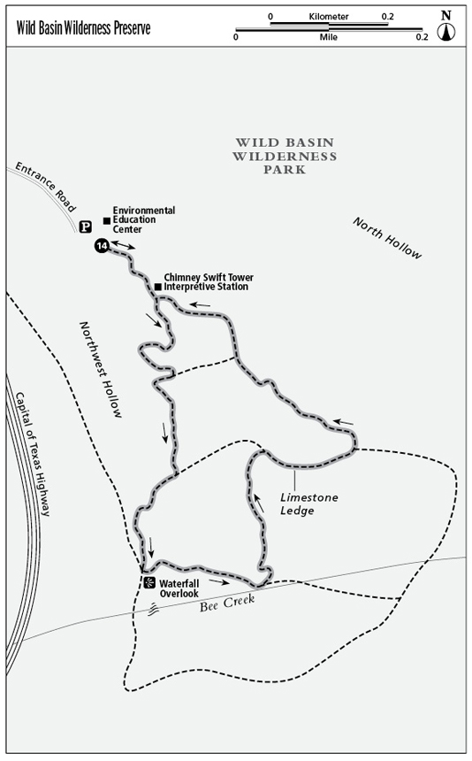
Start at the trailhead behind the environmental education center, heading east and then south. The center has a great deck that overlooks the valley. Seven short trails (Arroyo Loop, Laurel, Falls, Creek, Woodland, Ledge, and Triknee) are combined in this hike to form a counterclockwise loop. The trails are bordered on the west side by Northwest Hollow, which empties into Bee Creek. Sections of the preserve are close to Highway 360, so vehicle noise can be heard.
Be sure to pick up an interpretive trail map at the environmental education center. There are forty-six interpretive stations spaced along the trails that describe the flora and fauna, so be prepared to spend extra time on the hike. All the trail branches and intersections are well marked. The entire preserve is environmentally sensitive, so it’s important to stay on marked trails. The trails in the first half of the hike head gently down, while those in the last half have an elevation increase of more than 300 feet. The canopy cover alternates between dense shade and open sky. Bring a hat, water, and sunscreen.
About a half mile into the hike, reach interpretive station 9, where mountain laurel shrubs are shown and described. They are the harbingers of spring with their showy clusters of bluish purple flowers, and in the fall their seeds are hard shelled and red. The flowers and seeds are very poisonous if eaten by humans or animals, so alert your curious young folks.
Continue heading south on the Arroyo Loop Trail until you reach the intersection with the Laurel Trail. Take the Laurel Trail south until it ends at the Falls Trail. Follow the Falls Trail south to the small waterfall on Bee Creek. There is a concrete bench in a shaded area that overlooks the falls and creek. This is a good spot for photo ops. Take the Creek Trail east, passing interpretive markers G through K, and then turn left (north) at the Woodland Trail.
The Woodland Trail has a steep section where water bars and limestone outcrops act as steps. It can be strenuous going up and down these steps. There are sharp 15- to 20-foot drop-offs on the left side. Turn right onto the Ledge Trail, heading east. About 20 feet from the trail there is a low limestone outcrop that gave the Ledge Trail its name. Follow the Ledge to the junction of Possum and Triknee. On Triknee there is a wood bench with board slats over the top to shield the sun. Take Triknee to Arroyo, and then backtrack.
Miles and Directions
0.0Start at the Arroyo Vista trailhead behind the environmental education center. Pay the voluntary entrance fee at the donation box. Follow the trail a short way east, and then head south.
0.1Pass the Arroyo Vista and Waterfall, 0.7 mile trail marker on the left.
0.2Pass the Chimney Swift Tower interpretive station on the left. Reach a Y and take the right branch (south), and then bend right (west).
0.3Reach interpretive stations 5 and 6, and make a hard left, heading south.
0.4Take a hard left, making a semicircle to the right and heading west.
0.5Heading southeast, reach a trail intersection with the Laurel Trail and a waterfall on the right. Turn right, heading south, and pass interpretive sign 10. The trail surface is rough and rocky.
0.6Reach a T and take the right branch, bearing southwest toward the waterfall. The left branch goes to the Ledge Trail.
0.8Reach the overlook for the waterfall on Bee Creek. At the overlook, turn left (east) onto the Creek Trail. The Madrone Trail is to the right.
1.0The Woodland Trail intersects from the left. Turn left onto the Woodland Trail and head north toward the Ledge Trail.
1.3The Woodland Trail Ts into the Ledge Trail. Turn right onto the Ledge Trail, heading east toward the Possum Trail.
1.5After bearing left and heading north, intersect the Possum and Triknee Trails. Turn left onto the Triknee Trail, heading northwest.
1.7Follow the Triknee Trail to where it ends and joins the Arroyo Vista Trail. Continue straight on the Arroyo Vista for a short
1.7Follow the Triknee Trail to where it ends and joins the Arroyo Vista Trail. Continue straight on the Arroyo Vista for a short distance west, and then make a hard right, heading north.
1.9Bear left, heading west; cross a short bridge; and continue to follow the Arroyo Vista to interpretive station 2. Backtrack from this point to the trailhead and the environmental education center.
2.1Arrive back at the trailhead.