· · ·
As a scientist, I have my own dream, that a moratorium be put on the cutting of what is left of the global forests and that ordinary people with an acorn and a shovel begin the long road back to nature.
DIANA BERESFORD-KROEGER, Arboretum America, 2003
THE GREAT LAKES HAVE HAD a glorious past. In 1910, when no threat to their majesty and permanence seemed possible, the poet Wilfred Campbell wrote that “there is no more beautiful, enchanting and sublime portion of the American continent” than the Great Lakes. Today, despite alterations to the cast of characters in the Great Lakes diorama, it still presents a breathtaking, mesmerizing picture.
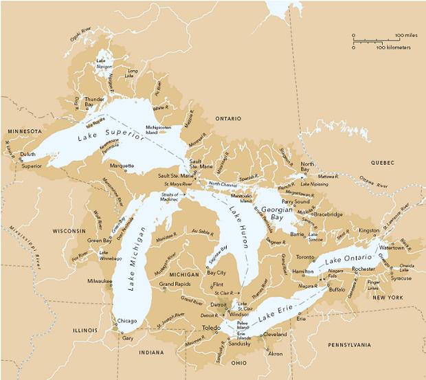
Even in the most populous and industrialized portions of the Lakes—the south shore of Lake Erie, the western end of Lake Ontario, along the Detroit River or the southern rim of Lake Michigan— there are isolated spots so pristine, so reminiscent of bygone eras, that time seems to have passed them by as a river flows around dry, mossy boulders. On the remoter shores, around Georgian Bay, on Manitoulin Island or the north shore of Lake Superior, it is still possible to gaze out at the vast expanse of sunlit water or follow a rushing river up into the Canadian Shield and imagine oneself the first human being to set eyes on an undisturbed wilderness.
To Campbell, the Lakes region was “in many respects the most favored in North America,” and that too remains true. The watershed is often cited, with the Grand Canyon and Mount Denali, as one of the natural wonders of North America. The Lakes will continue to shine, in Campbell’s words, “when we and all our dreaming lie low in dust.” But the Lakes have changed, and are changing, occasionally in ways that are beyond our control—or should be—and very often in ways we can control—and must.
If I were to board a freighter today and sail the length of all five Great Lakes, as I did in 1982, I doubt I would observe much difference between the Lakes as they are now and as they were twenty-five years ago. More traffic, perhaps, more congestion in the canals. More lights along the shorelines at night, but not many. There will be more changes in the future, however: demographers predict that the population of Toronto will reach 7.7 million by the year 2025, by which time, the U.S. Census Bureau forecasts, the population in the Great Lakes states will have soared to 73.5 million.
Environmental awareness has increased in the past three decades, and I would see more and healthier coastal wetlands, more bald eagle nests, and more cormorants energetically beating their wings a few feather-lengths above the waves. The water would be cleaner. Since the International Joint Commission (IJC) introduced its revised Great Lakes Water Quality Agreement in 1987, which was already an improvement over the original 1972 agreement, pollution entering the lakes has declined substantially from the toxic levels that persisted during the dark days of the 1950s and ’60s.
Lake levels lowered by increased evaporation threaten coastal habitat such as this embayment on Lake Superior’s north shore.
The problem of pollution in the Lakes has not gone away, however. Estimates are that, because of the different sizes and water replacement rates of the Lakes, if we stopped dumping toxic chemicals into the lakes today, it would take six years for Lake Erie to flush itself 90 percent clean, twenty years for Lake Ontario, one hundred years for Lakes Michigan and Huron, and five hundred years for Lake Superior. Of course, we have not stopped dumping chemicals into the Lakes. Every two years since 1980, the IJC has published a report card on progress in cleaning up the Lakes, and while each report celebrates advances, the authors also point out how much work is still to be done if the chemical integrity of the Lakes is to be restored. “We have made progress on that commitment,” they wrote in the 2002 report, “but, with regret, we declare again, as we did in 2000, that the power of the vision captured in the Agreement has generated neither enough action nor full recovery.”
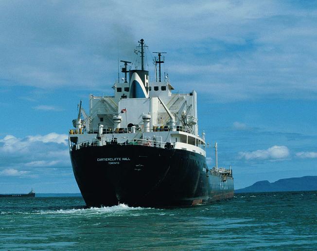
If water levels in the canals continue to decline, bulk carriers like the Cartiercliffe Hall may disappear from the Lakes, as more grain will be shipped through Churchill, Manitoba.
Each report has focused on a different problem. The 2000 report documented the appearance of new, unidentified chemicals; scientists could name only 30 percent of the substances they found in Great Lakes salmon, snapping turtles, and herring gulls. In 2002 it was PCBs: “Concentrations of PCBs in waters of all Great Lakes are approximately 100 times higher” than was considered safe, and the most significant exposure to them was through eating fish. Signs around Lake Michigan warning people not to eat fish caught in the lake had been removed in 1997, but two years later they went back up when carp, walleye, and perch from Saginaw Bay tested high for PCBs and dioxin. The signs are still there.
In 2004, the IJC focused on mercury. Although mercury discharges from paper mills in the United States and Canada “dropped substantially” from 1990 to 1999, the United States was still emitting 105 tonnes (116 tons) of it each year, Canada was adding another 11 tonnes (12 tons), and much of it was ending up in the Lakes through airborne emissions from coal-fired power plants. Following warnings from the EPA and the FDA, the report recommended that we not eat the organs, fat, or skin of any fish caught in any of the Great Lakes, and that we consume the flesh of only small species such as bass, pike, walleye, or perch, in quantities no greater than 170 grams (6 ounces) a week. These local advisories, the report stated, were “expected to exist for decades to come.” And indeed, more recent studies have extended that warning to the oceans: in 2007, Health Canada suggested that children and pregnant women avoid eating canned albacore tuna and shark more than twice a week because of high mercury levels worldwide, another reminder of the close links between the Great Lakes ecosystem and the larger world.
But the longest-lasting and most perplexing pollution problem lies hidden in the lakebeds. Since it is too soon for most of the pollution that was in the Lakes in the 1970s to have flushed out, reduced contaminant levels in the upper waters of the Lakes means that most of the pollutants have settled into the sediments. “The persistent toxic substances found in contaminated sediment,” the IJC wrote in its Tenth Biennial Report, released in 2000, “are the dominant issue” in those basin areas targeted by the commission for particular attention. Bottom-feeding fish and mollusks ingest them, and disturbances of the lake bottom rerelease them into the water. Either way, the toxins return to the food chain. In its 2002 report, the IJC warned again that “without sediment cleanup, injury to the health of humans, fish and wildlife will continue.”
It is difficult to avoid disturbing sediment. Zebra and quagga mussels drag themselves about on the lake bottom, insect larvae burrow into the mud, currents and ice stir the benthic soup, lake freighters churn the beds with their prop wash. And how do you dredge a canal without literally agitating the sediments that line its lowest depths? In the late 1970s, the U.S. Army Corps of Engineers (USACE) announced a plan to deepen and widen the St. Lawrence Seaway from stem to stern, to permit the passage of oceangoing vessels with a draft of 9.8 meters (32 feet). The USACE also wanted to open the seaway to winter navigation, which would require the Coast Guards of both countries to keep the canals and shipping lanes ice-free. This was before the days of environmental assessments, and no one knew what effect year-round shipping and reduced ice cover would have on aquatic organisms in the Lakes and along the shores. Nonetheless, the proposal met with immense opposition, especially from residents of the Thousand Islands, and even attracted the involvement of the infamous peace activist Abbie Hoffman. In 1984, the U.S. Congress rejected winter navigation, but the upper Lakes were granted an extended season: the locks at Sault Ste. Marie, which had been operating from April 1 to December 14, were allowed to remain open until January 7, plus or minus two weeks.
In 2002, the USACE again announced a plan to deepen and widen the St. Lawrence Seaway—including the complete removal of two of the Thousand Islands—and to build longer locks that would accommodate for the first time 305-meter (1,000-foot) oceangoing Panamax vessels all the way to Duluth and Thunder Bay. Apart from the impact this development would have on wildlife habitat, such a massive disturbance of lake sediments would have put hundreds of millions of tonnes or tons of sequestered PCBs and other pollutants back into circulation, as the USACE’s own “reconnaissance” study pointed out. (Part of its plan was to dredge canals and harbors to 15.3 meters, or 50 feet, and dump the contaminated sediment in deeper water at the center of each lake.) Again, opposition from a coalition of fifty environmental groups put the proposed dredging on hold, at least temporarily. The scheme has not been rejected, merely shelved until the cost-sharing governmental partners decide whether to go ahead with the funding. Meanwhile, projections are that the seaway, especially the Welland Canal, will reach carrying capacity around the year 2030. It’s not unlikely that some time before then, the USACE will be back in Washington and Ottawa with another plan to improve and extend seaway navigation. The USACE did receive authorization to build a new lock long enough to accommodate the Panamax vessels at Sault Ste. Marie, Michigan, in anticipation of the expected onrush of oceangoing traffic.

The Canada goose has been ubiquitous around the Great Lakes since its return from near extinction in the 1940s.
The organisms most affected by polluted sediments are those that live in deep water. In fact, the true legacy of the postwar years in the Great Lakes is the number of deepwater species that have disappeared as a result of contaminants. As well as the blue pike, three of the five species of ciscoes (closely related to the lake whitefish) that once thrived deep in the Great Lakes have become extinct: the last of the deepwater ciscoes, which occurred only in Lakes Huron and Michigan, was caught in 1951; the blackfin cisco, which inhabited all the Lakes except Erie, has not been reported since the 1960s; and the longjaw cisco, another deepwater fish found only in Lakes Huron and Michigan, vanished in the 1970s. The deepwater sculpin, an important food fish for lake trout, was extirpated from Lake Ontario, although a small population has recently been reported there, and remains threatened in Lake Erie, where only juveniles have been found.
The IJC continues to monitor water quality, and many improvements have been made. Lake Erie has been restored to oxygenated health once more, and although phosphorus levels seem to be creeping up again, laws and inspection processes are in place. Increased vigilance will eventually identify the sources and halt the increase. Like DDT and PCBs, phosphorus is a manageable problem. The same cannot be said, however, for some of the other threats to the physical integrity of the Lakes.
A WHOLE NEW FOOD CHAIN
As we have seen, many of the native species that dominated the Lakes ecoregions for the past 10,000 years have disappeared or been crowded out by alien invaders. More than 185 nonindigenous aquatic species have already found a permanent home in Great Lakes waters, and today most of the links in the Lakes’ food chain are dominated by exotic species. In the benthic mud of Lake Ontario, native gastropod snails have been replaced by the New Zealand mud snail. The most common alga in Lake Ontario phytoplankton now is Thalassiosira baltica, an import from the Baltic Sea. The dominant organisms in zooplankton are the spiny waterflea and the fishhook water flea, which turned up in the Lakes in 1982 and 1998 respectively, predators that feed on other zooplankton, including native copepods. These are eaten by round gobies, alewives, and Pacific salmon, all introduced species, and their fingerlings are snatched up by double-crested cormorants, which have recently invaded the Great Lakes in unprecedented numbers.
There is currently no effective mechanism in place to control the introduction of new species into the Lakes. The most common method of entry—and the focus of the IJC’s concern—is via the ballast tanks of ships arriving from foreign ports. Measures to prevent new introductions have been taken. Since 1993, for example, ships leaving ports in Europe or Asia have been required to empty their ballast tanks in mid-ocean and refill them with saltwater before entering the Lakes. But since then the rate of nonindigenous species coming into the Lakes has actually increased. Larger species are not getting in, but new, smaller organisms have begun showing up. The fishhook water flea was detected in Lake Ontario in 1998 and has rapidly ousted native types; it spread into Lake Michigan the next year, probably in ballast water taken on by a freighter in Lake Ontario. Obviously, stricter regulations are required, forcing all ships to manage their ballast water in all lakes to prevent the inadvertent introduction of alien species.
Regulations are also being proposed by the IJC for ships entering the Great Lakes without ballast in their tanks—the so-called NOBOBs—which until now have been exempted from the rules applied to ballasted ships. NOBOBs, which make up nearly 70 percent of Great Lakes traffic, have been allowed to flush out their “empty” ballast tanks in Great Lakes ports. But ballast tanks are never completely empty: deposits accumulate in the tanks below the pump level and may contain seeds, eggs, and larvae of invasive species that are then released into the Lakes. The IJC is calling for controls that apply to all ships coming into the Great Lakes, whether they contain freshwater or saltwater ballast or no ballast at all.
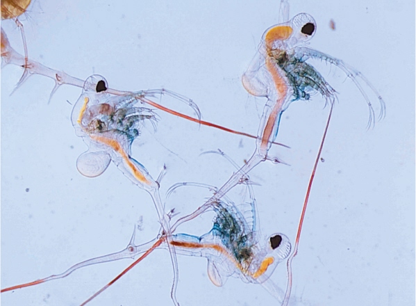
The spiny waterflea, one of the latest in a long series of invasive species now making their homes in the Great Lakes.
Before such regulations can be passed, there is much work to be done. Funding has to be found, research conducted, technology perfected, and inspection routines established. Even if the required legislation were passed today, the IJC calculates that it would take five to eight years for it to come into force. At the rate new nonindigenous organisms are entering the Lakes, there could be a dozen new species inhabiting Great Lakes waters before measures are in place to prevent or control them. And each one could be as devastating to native species and habitat as sea lampreys and zebra mussels have been in the past.
PIPE DREAMS
Since the beginning of European settlement around the Great Lakes, our idea of water—like that of nature itself—has undergone a fundamental change. As a society, we no longer see water as simply part of the landscape, a passive natural element; increasingly, we view it as a resource to be harnessed and exploited. We have become like timber merchants who regard a tree not as a living member of a forest ecosystem but as so many board feet of lumber. Water has always been important for drinking and as a means of transportation, just as trees have long provided wood for fuel and building. But until the early 1800s, transportation was dependent on the location of water; by the end of the nineteenth century, engineers were relocating water to provide transportation where it was needed, and the Age of Canals was under way.
Engineers also moved water for purposes other than transportation. Municipalities around the Lakes began withdrawing massive amounts of water, not only for drinking but also for industrial use. The amount taken from the Lakes increased at an incredible rate: in 1985, cities, industries, and power generators took 75 billion cubic meters (2.65 trillion cubic feet) of water from the Lakes per year. About 9.3 percent, or 7 billion cubic meters (247 billion cubic feet) per year, was for household use; the rest went to manufacturing, which soaked up 24.6 billion cubic meters (868.7 million cubic feet) of water a year, and power production (water used to cool nuclear reactors, or passed through turbines to create electricity), which used 43.8 billion cubic meters (1.54 billion cubic feet) a year. By 2002, power production alone accounted for 95 percent of all withdrawals—3 billion cubic meters (106 billion cubic feet) per day—and total water withdrawals had jumped to 1169 billion cubic meters (41.3 trillion cubic feet) a year. It has been estimated that not a drop of water leaves the Lakes without having passed through the cooling system of a nuclear reactor somewhere along its journey from Duluth. Most of that water is eventually returned to the lake it was drawn from. But returned water often comes back at a higher temperature, and it is drawn from the lake’s bottom waters and returned to the lake’s surface.
At least the water was used in the Great Lakes basin. In recent years, numerous proposals have been put forward to divert water out of the basin, for use as far away as Texas. The Ogallala Aquifer is a subterranean body of water underlying nearly 1.5 million square kilometers (600,000 square miles) of the American Midwest, stretching roughly from western Texas, Oklahoma, and New Mexico all the way north to South Dakota. It was formed at the same time as the Great Lakes from glacial meltwater that originated in the Rocky Mountains. Historically it has been tapped by ranchers of the High Plains for crop irrigation, but in many places a century of continuous pumping has depleted the store of fossil water beyond the aquifer’s ability to replenish itself. The Ogallala is drying up. As early as 1982, a U.S. federal study predicted that within half a century the aquifer would no longer sustain the 5.2 million hectares (12.8 million acres) of cropland that had come to depend on it. By 2020, 40 percent of the farmers drawing from the Ogallala would have to look for their water from some other source or else decommission their land. More recent studies, undertaken in the increasingly dry years of the late 1990s, suggest that 2020 was an optimistic date. As Marq de Villiers notes in his book Water, “If there is not to be a large-scale collapse—if three hundred thousand people are not going to be destitute, and a substantial American industry consigned to the trash can of history—something will have to be done. But what?”
When the Ogallala Aquifer was full, it contained as much water as Lake Huron, a fact that has not escaped the attention of High Plains farmers, nor of the USACE. In 1983, the USACE investigated the feasibility of building a pipeline to divert 24 million cubic meters (848 million cubic feet) of water a day from Lake Superior into the Missouri River, a distance of about 965 kilometers (600 miles), from somewhere around Duluth, Minnesota, to somewhere in South Dakota. The project was abandoned when the USACE determined it would require seven 1,000-megawatt nuclear power plants to run the pumps that would move the water uphill onto the Great Plains. In other words, the decision not to take water from the Great Lakes was made for economic, not logistical or environmental, reasons.
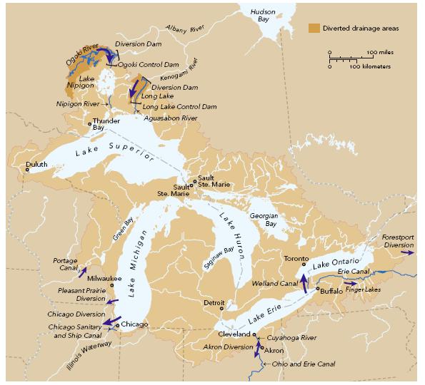
WATER DIVERSIONS

Pitcher plants are native to sphagnum bogs throughout the basin. Bristles lining the curled leaves help trap insects, which are then ingested.
Similarly, and almost simultaneously, the province of Quebec under Premier Robert Bourassa came up with an even more harebrained scheme. Named the GRAND Canal (for Great Recycling and Northern Development Canal) and expected to cost C$100 billion, the proposal called for the construction of a dyke across the top of James Bay, separating it from Hudson Bay. When all the rivers emptying into James Bay had turned it into a huge freshwater reservoir, the water would be diverted south into Lake Superior—so that water taken by the USACE from the American side would be replenished on the Canadian side. The project was officially cancelled by Bourassa’s successor Jacques Parizeau, after much public outcry, but fears remain that the dreams of the Grand Canal Co. Ltd. have simply been put on hold until the political climate warms to the idea of selling engineered water to the drought-stricken American Southwest. (A former president of the Grand Canal consortium, Simon Reisman, was the chief Canadian negotiator of the North American Free Trade Agreement.) Once again, a dubious scheme was shelved not because of the disastrous effect it would have on the James Bay ecosystem— on the fish, plants, and other organisms that for millennia have relied on specific salt levels in James Bay water—but because of the absence of a market for Canadian water when the Missouri River project fell through. When the economics of such megaprojects begin to make sense, as some day they may, the blueprints for them could be dusted off and propped back up on the NAFTA partners’ drawing boards.
It’s not as though such proposals are without precedent. The idea that water is a commodity, and a highly mobile one at that, has made the Great Lakes the focus of diversion projects since the middle of the nineteenth century. They seem to stem in part from our apparently compulsive need to push water around like children playing in a roadside ditch during spring runoff. Most of these projects, which involve irreversible tampering with Great Lakes water levels, are still worrisome from an environmental point of view. If the Great Lakes basin is a holding tank for most of North America’s freshwater supply, it is a tank that has, over the years, sprung a lot of leaks.
The New York State Canal System, for example, which includes the Erie and Oswego canals, allows up to 433,000 cubic meters (15.3 million cubic feet) of Lake Ontario water per day to drain into the Hudson River watershed, and has done so since the canal opened in the early 1800s. During periods of drought in New York City, such as occurred in the 1960s and again in the mid-1980s, city officials suggested that that amount be vastly increased, rather like opening a gigantic fire hydrant when New Yorkers want to beat the heat. So far these proposals have met with such resistance from Great Lakes basin residents that they have been dropped. Dropped, that is, until the next heat wave.
When high levels of radium were found in two wells in Pleasant Prairie, Wisconsin, in 1982, the village council decided to divert water from nearby Lake Michigan and discharge it into the Mississippi basin. They received approval from the state to take 12,000 cubic meters (424,000 cubic feet) a day, with the proviso that by 2010 they will have built a pipeline that would return the water to Lake Michigan. Great Lakes United, a citizens’ environmental group that monitors water diversion projects, has expressed alarm at this solution, stating that new housing developments in Pleasant Prairie are placing heavier demands than expected on the diverted water, and that two versions of the agreement between the village and the state exist, a signed version and an unsigned version. The proviso to return the water to Lake Michigan by 2010, it claims, is in the unsigned version.
Then there is the Chicago Sanitary and Ship Canal, stretching 48 kilometers (30 miles) between Lake Michigan and the Illinois and Des Plaines rivers. Work began in 1848 on its prototype, the Illinois and Michigan Canal, which cut across the narrow divide separating the Chicago River, a small, sluggish stream that meandered through Chicago and drained into Lake Michigan, from the larger Illinois River, which flowed south into the upper Mississippi Valley. In 1860, deaths in Chicago from typhoid fever, cholera, and dysentery began to soar, and by 1900, they had reached 65 per 100,000 population, the highest toll in the country, because the city’s sewage was dumped directly into the Chicago River, which emptied into Lake Michigan close to where the city took its drinking water. The first section of the Chicago Sanitary and Ship Canal was dug in 1905, a short, 8-kilometer (5-mile) ditch that linked the Chicago River with the Des Plaines River, also part of the Mississippi system. Since Lake Michigan is higher than the Des Plaines, water in the Chicago River began flowing backward, draining water and sewage from Lake Michigan into the Mississippi system at the rate of about 283 cubic meters (10,000 cubic feet) per second. The engineers had in fact reopened the ancient Chicago Outlet through which the upper Lakes once drained into the Gulf of Mexico. Residents on Lake Michigan grew alarmed when water levels on the lake began to decline, and in 1929 the U.S. Supreme Court limited the diversion to 42.5 cubic meters (1,500 cubic feet) per second, or nearly 3.7 million cubic meters (130 million cubic feet) of water daily. That amount has crept up over the years; in 1967, the Supreme Court adjusted the allowable discharge drastically, and today Chicago’s sewage still ends up in the Gulf of Mexico, washed there by 8 million cubic meters (281 million cubic feet) of Lake Michigan water every day.
In 1995, the state of Michigan claimed that Illinois was violating the 1967 ruling by allowing an extra 756,000 cubic meters (26.7 million cubic feet) of water a day to flow out of Lake Michigan. Illinois countered that the locks and flow meters maintained by the Corps of Engineers were old and leaking. By this time an agreement had been signed among the eight states bordering the Great Lakes which stipulated that no one state could divert water from the Lakes without the agreement of the other seven: Illinois was allowed to repair its locks and reduce the outflow to 1967 levels, and Michigan agreed not to prosecute over the violations that had already occurred.

A greater yellowlegs uses its long bill to skim the surface for small fish, tadpoles, and snails. Its breeding grounds are on the far northern tundra.
The diversion of Lake Michigan water through the Chicago canal has dropped the lake level by 5 centimeters (2 inches), not an alarming amount. But if the USACE plan to deepen the existing shipping channels and connecting linkages goes ahead, lake levels will drop further: dredging the St. Clair River to accommodate larger ships has already lowered both Lake Michigan and Lake Huron by a further 40 centimeters (16 inches). And, as urban centers continue to grow in the Great Lakes region and suburbs and industries require greater infusions of lake water, many new diversion proposals are certain to emerge.

Island white pines in Bing Inlet, Georgian Bay, Ontario.
Not all water diversions remove water from the Great Lakes. The Portage Canal, for example, completed in 1876 and linking the Wisconsin River to the Fox to provide a commercial route for ships between the Mississippi and the Great Lakes, diverts 240,000 cubic meters (8.5 million cubic feet) of water a day from the Mississippi watershed into Lake Michigan. (Although the canal was never used commercially and has long lain in disuse, plans were announced in July 2006 for a US$2.75 million “rehabilitation” of the canal for pleasure craft.)
In 1940, work commenced on a megaproject north of Lake Superior that since 1950 has diverted roughly 142 cubic meters (5,000 cubic feet) per second of water into Lake Superior that would normally flow into James Bay. The intention was to increase Ontario’s capacity to generate electricity at Niagara by diverting water into the turbines without lowering lake levels or reducing the amount of water flowing over Niagara Falls. Because of the size of Lake Superior, the diversion has raised Superior’s level by only 5 centimeters (2 inches). But diversions into the Lakes do not offset the effects of diversions out of them.
Lowered lake levels severely affect the human economy of the Great Lakes. When surface levels drop, either the lake bottoms have to be dredged deeper to accommodate shipping, or ships have to carry less cargo. Since 1997, coal and grain freighters on the Lakes have had to lighten their loads in order to navigate some of the shallower channels and locks; it takes 245 tonnes (270 tons) of cargo to lower a 229-meter (750-foot) ship 2.5 centimeters (1 inch) into the water, and so ships have to sail 245 tonnes (270 tons) lighter every time the lake level is lowered by that much. Low water levels also influence air quality by exposing contaminated sediments at the shoreline, which then dry out and evaporate into the atmosphere. And they threaten shorebird and fish communities by reducing the amount of water in coastal wetlands and other fish spawning areas.
Demands for Great Lakes water will rise in the coming decades. According to Adele Hurley, director of water issues at the University of Toronto’s Munk Centre for International Studies, water stress in the Missouri River, and therefore in the Mississippi, due to decreased snow melt in the Rockies, “will sooner or later affect every single water drinker around the Great Lakes.” Diversion projects added to increased local household and commercial use have already put tremendous stress on lake levels. As early as 1981, the IJC predicted that water consumption from the Great Lakes would grow fivefold by the year 2035. Continuing increases in population within the basin will further increase withdrawals. But the biggest challenge to Great Lakes water levels, and therefore water quality, is going to come from a different source: global warming.
CHANGING CLIMATE, CHANGING LAKES
According to the Nature Conservancy of Canada and Environment Canada, global warming is expected to cause a rise in temperatures in the Great Lakes region of between 3˚C and 7˚C (5.4˚F and 12.6˚F) in winter and between 3˚C and 10˚C (5.4˚F and 18˚F) in the summer when the atmospheric carbon dioxide level reaches 360 parts per million, double that of pre-industrial-revolution days. Many scientists suggest that level will be reached by the year 2050, perhaps even by 2030. Such dramatic changes will lead to increased evaporation, which, along with reduced ice cover, water diversion and current dredging projects, will bring water levels in the Great Lakes much lower than historical levels. Experts with the U.S. Global Change Research Program predict that increased evaporation due to higher temperatures could drop lake levels by as much as 1.5 meters (5 feet) by mid-century.
Such a decrease in the depth of canals and shipping lanes would necessitate additional and widespread dredging of the St. Lawrence Seaway in places where supertankers are barely clearing the bottom now. The resulting disturbance of toxic sediments could bring back the pollution levels of the 1960s. Similarly, the Chicago Sanitary and Ship Canal would have to be deepened to prevent the Chicago River from reverting to its initial flow back into Lake Michigan. This would require engineers to lower the channel bed by 1.2 meters (4 feet) through solid rock for a distance of 48 kilometers (30 miles) to get the water flowing into the Illinois River again.
But the consequences of lower lake levels for commercial traffic and contaminated sediments are not the only worrisome aspects of global climate change. Perhaps the most serious long-term effects will be to the region’s natural ecosystems, to the animals and plants that have, over the past 10,000 years, adapted to the historic climate in and around the Lakes. Global warming is a planet-wide, all-inclusive phenomenon, and it’s difficult to predict exactly what it will mean to a particular region. But scientists are giving us a general idea of what we have to look forward to.
Since the late 1980s, when the NASA physicist James Hansen sounded the first alarm to the U.S. Senate that global warming was a reality (one member of that Senate committee was Al Gore), the effects of climate change have become increasingly evident: consistently rising temperatures, especially in the inner cities of Chicago and Toronto, have carried with them increased health hazards for the elderly, the homeless, and people with respiratory problems, higher demands on power facilities for air conditioning, rising rates of evaporation not only from the Lakes but also from forests and agricultural croplands, more demand for water for irrigation and cooling, and spikes in the amount of water vapor, an extremely potent greenhouse gas, entering the atmosphere.

Reintroduction of the massasauga rattler, the basin’s only venomous snake, has been successful but contentious in southwestern Ontario.
A year after Hansen’s wake-up call, Canadian scientists told the House of Commons Standing Committee on the Environment that an average global temperature increase of 2˚C (3.6˚F)—which they expected, at the time, would be reached by the end of the twentieth century—would have significant effects in the Great Lakes region. More recent studies have refined that analysis. The IJC’s report Climate Change and Water Quality in the Great Lakes Region, published in 2003, and the most recent report from the Intergovernmental Panel on Climate Change, published in 2007, found that higher summer and winter temperatures would greatly affect the boreal forest north of Lake Superior by increasing the risk of forest fires, creating more favorable conditions for insects such as the spruce budworm, and causing some northern tree species to move farther north. According to the House of Commons report, “local extinctions” can be expected to occur. Increased evaporation would lower water levels in all five lakes; severe drought would cause extensive crop failures in Ontario’s agricultural heartland, especially for such crops as potatoes, corn, and soybeans, which require large amounts of water. One study, conducted by the University of Guelph, predicted agricultural losses of C$170 million a year in Ontario alone.
The recent dramatic increase in hurricanes and tropical storms coming from the American South is a direct consequence of higher surface temperatures in the mid-Atlantic. Although people living in the Great Lakes basin might be tempted to think that tropical storms don’t affect them, intense storm activity in the South alters weather patterns in the Great Lakes region in weird and unpredictable ways. September 2005—when Hurricane Katrina destroyed much of New Orleans— was one of the warmest Septembers on record throughout the Great Lakes basin, and water temperatures were also at record highs. November, however, was one of the coldest; more snow fell on Michigan’s Upper Peninsula that month than during any previous November in recorded weather history. A recent study in New York State found that there has been a significant increase in snowfall within the Great Lakes region since the 1930s, an increase not found outside the watershed. The city of Syracuse, New York, for example, experienced its four heaviest snowfalls ever in the 1990s, which was also the warmest decade of the century. The study, published in the Journal of Climate, blamed the contradictory phenomenon on global warming: “Recent increases in water temperature are consistent with global warming. Such increases widen the gap between water temperature and air temperature—the ideal condition for snowfall.”
In some areas of the Great Lakes, winter ice is melting much earlier than usual; in other areas, it’s not forming at all. Ice duration and extent have been slowly declining for at least a century. One study, conducted in 2000 at Lake Mendota near Madison, Wisconsin, showed that between 1856 and 1998 ice duration decreased by thirty days, with a record low in the winter of 1997–98. One result of reduced ice cover is a longer shipping season, with consequent increases in shore erosion (ice cover reduces waves and protects shorelines from being washed away) and increased evaporation, since surface water can evaporate year-round. Another is a change in the amount of light radiation, or the albedo, in the region. When the Lakes are covered with ice, they reflect more of the sun’s heat away from the earth’s surface. Open water, being darker, absorbs solar energy and contributes to already rising water temperatures.
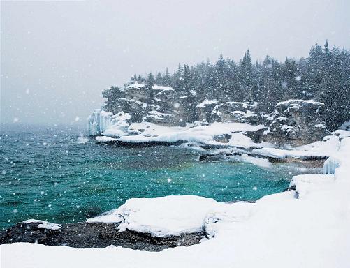
Snow squall at Indian Head, on Ontario’s Bruce Peninsula. As lake surfaces warm, reduced ice cover in winter could mean more shore erosion and a faster rate of evaporation.
The U.S. Environmental Protection Agency (EPA) points to other possible consequences of global warming. Fish spawning streams around the Lakes will become warmer, reducing habitat for cold-water species such as trout and salmon by as much as 86 percent. Although spawning times are determined by the number of hours of daylight, which does not change, the success of the spawning—the number of hatchlings that survive to become adults and perhaps the ratio of male hatchlings to female—depends to a great extent on water temperature. A variation of a fraction of a degree above or below normal can make a huge difference in a given year’s fish populations. Fishers know that if there is especially cold weather at spawning time, there will be a bumper harvest of lake trout or whitefish the following summer, since those are cold-water-spawning species. Fishers want “a cold fall and a dirty winter.”
The smallmouth bass, originally restricted to the Great Lakes, is now one of the most popular sport fishes in North America and is found in England, Russia, and Africa.

Warm falls and mild winters, on the other hand, are disastrous. Cool-water species, such as pike, walleye, or alewives (which spawn in midsummer), will also be adversely affected by warmer temperatures. John Casselman, a fish biologist with the Ontario Ministry of Natural Resources who has been tracking water temperatures and correlating them with fish growth patterns in Lake Ontario for the past three decades, estimates that with a water-temperature rise of 1˚C (1.8˚F), cool-water fish populations will decline by a factor of 2. In other words, only half the fish will survive to adulthood. After that the numbers soar off the chart: with a 2˚C (3.6˚F) rise, the populations will decline by a factor of 18, “and I won’t even predict what would happen if the temperature rises more than that,” he adds, although he mentions that a factor of 36 has been touted for a 4˚C (7.2˚F) rise.
Warm-water fish, however, such as largemouth and smallmouth bass and most exotics, “will explode,” says Casselman. An increase of 1˚C (1.8˚F) will raise fish production by a factor of 2.4; a 2˚C (3.6˚F) increase produces a sixfold increase; and a 3˚C (5.4˚F) rise yields a fifteenfold increase. Because of global warming, he adds, water temperatures in Lake Ontario have already gone up by almost 1˚C (1.8˚F)—more than that in some shallow embayments, such as the Bay of Quinte, where warm-water fish tend to spawn. This might explain why nonindigenous species such as the round goby have done so well in the Great Lakes: they spawn prodigiously in warm water, while the populations of their major native predator— walleye—plummet. It also suggests why such cold-water fish as lake trout are doing so poorly and have to be restocked every year. Salmonids spawn successfully in warmer water, but their principal food species—alewives and walleye—do not, and so young salmon have less food. Salmon do not eat round gobies.
Migrating birds could also find their favorite ponds or wetlands suddenly dry, or their migration dates out of sync with insect hatching times; they could arrive at their Great Lakes resting areas too late for the larval stages of the insects they rely on to fuel their migration. Even resident birds may find themselves feeling less at home. In Pennsylvania, for instance, the EPA’s Mid-Atlantic States Regional Global Warming Assessment has noted that an increase of 2˚C (3.6˚F) could mean that nine of the state’s native breeding bird species would no longer breed that far south. As southern grasslands and Carolinian tree species such as black walnut and black cherry slowly advance north, pushing the Great Lakes–St. Lawrence forest into northwestern Ontario and the boreal forest farther toward Hudson Bay, out of the Great Lakes basin, bird, mammal, and insect species will move with them. A 1997 study of the bobolink, the black and white songbird with a bright yellow patch on the back of its neck, now common in summer meadows throughout the region, found that during extremely warm summers the species did not nest as far south as it did in cooler summers; the report predicted that with a climate change such as is expected by mid-century, the bobolink would no longer be found breeding south of the Great Lakes.
Other birds might not be found at all. As a result of global warming, certain tree species now native to the Great Lakes basin, including quaking aspen, yellow birch, red pine, white pine, and jack pine, may decline by 50 to 70 percent. This would seriously affect species that depend on these trees for their survival. The endangered Kirtland’s warbler is an example. Between 1900 and 1986, the species was seen in Ontario only thirty-seven times. In the 1970s, bird counts indicated that there were fewer than 250 breeding pairs of Kirtland’s warblers left in North America. Kirtland’s warblers breed almost exclusively in the northern portion of Michigan’s Lower Peninsula, in small stands of immature jack pine growing on sandy ground. Habitat restoration by selective fires and forest regeneration in the 1990s helped to increase the number of breeding warblers: in 2005, there were 1,300 males in the Lower Peninsula. The disappearance of half that region’s jack pine stands because of global warming would put the Kirtland’s warbler back in peril of extinction.
The IJC’s 2003 report on climate change outlined some l ikely scenarios, based on studies of alterations that were already taking place. The boreal forest, where climate changes are slightly accelerated because of the northern latitude, offers an indication of what lies ahead. Between 1970 and 1990, the average temperature in the boreal region increased by 0.55˚C (1˚F), precipitation decreased by 60 percent, and evaporation increased by 50 percent. Evapotrans-piration— the loss of water vapor from plants—also increased. The Great Lakes basin already loses 65 percent of the water that falls on it through evapotranspiration. A significant increase in moisture loss would have serious consequences for the boreal ecosystem, which depends on damp soil and bogs for its continued health.

One of the rarest birds in the Great Lakes basin, the Kirtland’s warbler breeds in only a small area of Michigan’s Lower Peninsula.
It’s not a hopeful picture. Less ice, more evaporation, more shore erosion, less precipitation. Fewer native species, more alien plants, unstoppable aquatic organisms. These are enormous transformations to an ecosystem that has been trying to stabilize for more than ten millennia. The IJC report implied that rather than try to prevent these changes—it may be too late for that—we should learn to anticipate and adapt to them. Develop new crops that can tolerate a drier climate; shift the economic bases of certain communities from winter recreation to less climate-dependent industries; build more confined disposal facilities to accept toxic sediments from dredged harbors and channelways.
These measures may help humans adjust to an altered climate, but what about the rest of the ecosystem? Most species can accommodate radical modifications in their habitats if those modifications take effect over sufficiently long periods of time. But if the schedules suggested by the most recent predictions are valid, the organisms most likely to thrive will be those that arrive here from a region that is already warm.
THE RISING TIDE
The governments of the states and provinces within the Great Lakes basin have gradually come to terms with the alarming news about the state of its ecosystem, and are aware of the threats that water diversion, global warming, and invasive species pose to its preservation. Organizations such as the International Joint Commission and the Great Lakes Commission, backed by citizens’ groups demanding more and better habitat protection and restoration, and supported by government-funded, scientific research, are taking positive steps toward returning the Lakes to something resembling their natural beauty and abundance. All acknowledge that future generations dwelling within the Great Lakes basin deserve to enjoy the same health and other, less tangible benefits as their ancestors did.
In the revised Water Quality Agreement of 1987 and later reports, the IJC identified forty-three Areas of Concern, or AOCs— specific harbors, wetlands, and stretches of shoreline on both sides of the border that had been so degraded by pollution or urban development that they were barely able to support aquatic life—and earmarked them for immediate restoration. Each AOC was mandated to come up with a plan for cleaning up its site and given a time limit within which to implement the necessary measures. Since then, some advances have been made, and precedents have been set to ensure that future restorations will be accomplished more easily.
Proof that aquatic ecosystems are changing for the better can be seen on the lakeshores of many of the major urban areas surrounding the Lakes. Waterfronts that once were functional but unsightly conglomerations of train tracks, warehouses, and factories are being transformed into parkland, residential developments, nature trails, and wildlife habitats. Windsor, Toronto, Detroit, Chicago, and Milwaukee have all transformed sections of their shorelines into attractive parks in which native wildlife species are returning. Even Ohio’s Cuyahoga River, which in the 1960s was so polluted that it famously caught fire, now flows through Cuyahoga Valley National Park, where recent surveys show that great blue heron nests are increasing at the rate of 5.6 percent per year.
In Waukegan Harbor, Illinois, one of the 26 Areas of Concern in the United States, 448 tonnes (494 tons) of PCB-laden sediments dredged from the harbor bottom were thermally treated and stored in confined disposal facilities. Similarly, Hamilton Harbour, at the western end of Lake Ontario, was one of 17 Canadian AOCs and has now been cleaned up to a great extent. Once 2,150 hectares (5,300 acres) of the most toxic water in the Lakes, the site of Canada’s largest concentration of industry and shipping, the harbor received not only industrial waste but also Hamilton’s raw sewage. Herring gulls from the harbor were found to contain 57 different toxic contaminants and had a reproductive rate of only 18.6 percent.
After the 1987 revisions to the Water Quality Agreement committed the federal governments of both Canada and the United States to clean up the AOCs, citizens’ coalitions in Hamilton began to work with government and industry representatives, scientists, and environmentalists to return the harbor to a healthier state while still maintaining it as an important industrial lakeport. Within five years, there was a plan calling for public access to the harbor, removal of contaminated soil, and the creation of Bayfront Park; by 1997, public access to the harbor had more than tripled, and the water was deemed safe for swimming. In addition, restoration of the Cootes Paradise marsh had begun, and C$13 million had been raised to add 63 hectares (156 acres) to the wetlands. New wastewater treatment facilities were built and existing plants upgraded, phosphorus discharges were lowered to federally mandated targets, and in many places fish habitat was brought back to preindustrial conditions.
The IJC wants to see cleanup work begin on two AOCs a year, and cleanups completed on two others, which would mean that all contaminated hot spots on the Great Lakes could be gone by 2030. This will require coordinated efforts from every level of government and an engaged citizenry, and the commission is confident that, given such cooperation, its goals can be achieved.
The Great Lakes can never be returned to the pristine condition in which Europeans found them three centuries ago, but with luck and much work we may once again be able to eat the fish, breathe the air, and drink the water. One bright sign for the future of the Great Lakes is the extent to which awareness of the many problems the basin faces is growing among politicians and citizens’ groups. Threats to the Lakes’ integrity are increasingly met with resistance.
Polls conducted in 2002 found that 55 percent of Great Lakes basin residents oppose the degradation of their environment because of the Lakes’ natural beauty; 54 percent cited the Lakes’ role in maintaining the balance of nature that sustains them; 52 percent felt the Lakes form part of their regional identity; and 64 percent accept a responsibility to preserve the Lakes for future generations. Politicians respond to such findings. Every lake and river, every bay, every ecosystem, every endangered or threatened species around the basin has its champions.

Canada geese stage for southern migration near Oshawa, on Lake Ontario. Their return each spring has become a symbol of conservation and renewal.
Dave Dempsey, author of On the Brink: The Great Lakes in the 21st Century, is perhaps more aware than most of the range and complexity of the challenges, but he is encouraged by the public’s growing engagement with the Great Lakes and their multifaceted issues. “If there’s good news,” he says, “it’s the slowly rising tide of consciousness. Somehow we have to get back to the idea that this is our home and we can’t afford to destroy it.”
VULTURE CULTURE
The turkey vulture is the only vulture species found regularly in the Great Lakes basin, and it has been migrating this far north only since the 1920s. A large, completely black-feathered bird with a bald, red head and a 2-meter (6.5-foot) wingspan, the turkey vulture looks like a large hawk when seen from the ground; like the hawk, it rides warm air currents, circling high overhead until prey is sighted or— in the case of the vulture—smelled (turkey and black vultures are two of the very few species of birds with a sense of smell). Unlike hawks, vultures hold their wings in a distinct V, or dihedral, shape.
Their expansion into the Great Lakes region has been attributed to a number of factors: more roads mean more roadkills, the turkey vultures’ main source of food, and the ban on DDT spraying has improved their reproductive rate. Global warming has also made northern areas more hospitable. Whatever the reasons, counts conducted by Bird Studies Canada at the Long Point Bird Observatory show that over the past fifty years, the turkey vulture population in the Great Lakes basin has increased by 15 percent annually, compared with only 2 percent in the rest of the continent.
Commenting on the near extinction of the California condor in the American West, the environmentalist David Brower remarked, “You know your society is in trouble when the vultures start dying.” In the Great Lakes region, the vultures are doing just fine.

The turkey vulture can smell decaying carrion from 300 meters (1,000 feet) and is often used by other opportunists to locate food. Natural gas workers also follow turkey vultures to locate pipeline leaks.
DON’T TOUCH
Poison ivy accounts for more than 350,000 reported cases of dermatitis every year. The plant’s toxic ingredient, urushiol, a resin that can be transferred only by touch, suffuses the entire plant, including stems, leaves, and roots. Because it does not evaporate in air, the resin can remain potent on clothes, pets, and even door handles for years. Furthermore, since poison ivy is a member of the cashew family, along with mangoes, cashews, and pistachios, eating those foods can bring on a renewed bout of dermatitis.
Recent studies suggest that global warming will cause poison ivy to become an even greater menace. In controlled-environment experiments, plant scientists at Duke University increased carbon dioxide levels by 54 percent—the amount atmospheric carbon dioxide is expected to increase by 2050 if we continue to burn today’s amount of fossil fuels—and found that poison ivy grew larger and three times faster than normal. Its urushiol level soared by as much as 33 percent. By mid-century, experts warn, giant poison ivy plants could be shading or choking out smaller shrubs on the forest floor, and cases of toxic reaction to it could triple to more than 1 million cases annually.
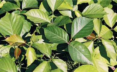
Poison ivy, with its shiny, trifoliate leaves, is found throughout the Great Lakes basin as a shrub, a tree or sometimes a vine.