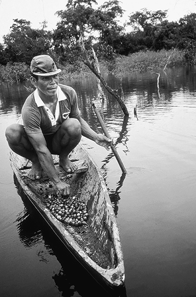
(Opposite) Harvesting the fruits of camu-camu (Myrciaria dubia) in Sahua cocha, Department of Loreto, Peru. The tops of the flooded camu-camu plants are visible in the background; the floodwaters were about two meters deep at the time of the photograph.
Sahua cocha and IIAP field station at Jenaro Herrera (S4°54´21´´, W73°40´07´´), fourteen hours up the Ucayali River from Iquitos, Peru, 1984–1987, 2011
I was on the lookout for interesting fruits from the moment I arrived at Iquitos, and the first one that caught my eye was a small red-and-green marble to golf ball–sized fruit called camu-camu (Myrciaria dubia).1 I saw it everywhere. Street vendors pushed carts loaded with baskets of camu-camu around town, women in the central market piled up plastic bags filled with the fruit for sale, delicious camu-camu juice drinks were available all over the place, and camu-camu sherbet was one of the first flavors listed on the signs outside the local ice-cream parlors. This was clearly one of the most popular native fruits in town. My first question was, I wonder where all these fruits come from?
I went around town and asked the street vendors, juice makers, market women, and ice-cream scoopers where they got their camu-camu fruit. What I really wanted to know was whether it was cultivated locally or “wild harvested” from the forest; I was hoping the latter. My informants all told me that they bought the fruit from sellers at the port,2 and that it came from someplace “upriver.” I started hanging around the port, and soon saw several chaucheros (dockworkers) climbing up the slippery bank from the river with huge bamboo baskets on their backs filled with camu-camu fruit.3 Once they had reached the top and put down their baskets, I began interviewing them. All the chaucheros told me the same thing: “The best camu-camu comes from the oxbow lakes outside Jenaro Herrera, about fourteen hours from Iquitos up the Ucayali River.”4
I had come to Peru to participate in a three-year study of the ecology and management of native fruit trees. As luck would have it, the local research institute (Instituto de Investigaciones de la Amazonía Peruana) with which I was collaborating had a small field station outside Jenaro Herrera. And it did take fourteen hours—and an overnight ride on a riverboat packed with swinging hammocks, motorcycles, innumerable sacks filled with rice, tubers, and electronic equipment, lots of children and babies, and a few water buffaloes—to get there. The station was located five kilometers from the town of Jenaro Herrera up a dirt road. About a dozen of us, mostly students and a few researchers, lived at the station, and I had a comfortable, palm-thatched hut with bathroom, running water, and even electricity for two or three hours most evenings. I also had the use of a wooden longboat named Myrciaria that had been made by a local boat builder and an incredibly knowledgeable and pleasant field assistant named Umberto Pacaya, who was a skilled boat driver, knew where to find all of the native fruits, and never once got lost in the forest. It was a great place to work.
On my first field excursion, I went to explore the two big oxbow lakes, Supay cocha and Sahau cocha, outside Jenaro Herrera, where the camu-camu was growing.5 The bank of each of the lakes had a 20–30-meter-wide strip packed with camu-camu shrubs. When the water level in the lake was up, it was hard to paddle through the canopy of the camu-camal (dense aggregations of camu-camu); when the water level was down, we had to crawl, climb, and pick our way through the tangle of stems with care. As soon as the water level in the lake had dropped enough to uncover the entire camu-camu population, we started laying out our inventory plots.
The plots were laid along a straight line with the edge of the lake on one side and the levee—where flooded forest was growing—on the other. We had to work fast because the water level in the lake was rising a little each day and the front of our plots was becoming submerged. We were able to finish ten plots before they were all flooded. We measured and tagged almost nine hundred camu-camu plants in the plots; over half of these were seedlings and saplings. To put this number in perspective, most tropical forest trees form natural populations with only a couple of reproductive adults per hectare; the camu-camu population I had put my plots in had an estimated thirty-eight hundred fruit-producing plants per hectare.
The camu-camu plants started flowering while we were still working on our plots. The species produces beautiful white blossoms with a pleasing fragrance and sweet nectar to attract bees for pollination, and bees constantly buzzed around us as we worked. As the water continued to rise, the trees started to form small fruits, and by the time the water level had reached a couple of meters, the crowns of the trees were completely covered with shiny red fruit. These either fell into the water, where they were subsequently eaten and dispersed by fish, or were collected by local villagers.6 Within a week or so, all the trees were completely underwater.
Although camu-camu is a terrestrial plant, it spends six to seven months each year in this state. Its life cycle is tied to the rise and fall of the oxbow lake, and in the few months it is out of the water, seeds have to germinate, saplings have to grow, and adult trees have to produce flowers; these have to be pollinated, and a large quantity of fruit must then be nourished to maturity—all before the waters rise again. The full sun and rich alluvial soils undoubtedly help the species fulfill these biological necessities in such a short period of time. Few other woody species can tolerate the severe annual flooding, so the camu-camu essentially has these fertile sites all to itself—another major advantage.
One of the important goals of my research was to estimate how much fruit the camu-camu populations were producing. This turned out to be somewhat complicated. When measuring the production of fruit by a plant population, the researcher usually tries to quantify the size-specific production: the number of fruits produced by plants of differing size. With this result, the researcher will multiply the fruit-production values for each size class by the number of plants recorded in that class to estimate total fruit production by the population. It is thus important not to mix the fruiting branches from big trees with those from smaller individuals. When water levels are low and the trees are completely uncovered, it is easy to see which fruiting branches belong to each individual. But when the water level rises, and it becomes harder to see which trunk a given branch is connected to, researchers can often make mistakes. To overcome this difficulty, we decided to number and label the branches pertaining to each sample tree with flags, and then move all the flags up as the water level rose. In this way, even when we could not see the main trunk of the tree, we could distinguish and separate out all of its fruiting branches.
Umberto Pacaya and I flagged the fruiting branches on twenty-five camu-camu trees of differing sizes and untied and retied hundreds of branch flags as the water level in the lake rose. We continued doing this for two years; the results were impressive.7 The natural populations of camu-camu growing at the lake produced between 1.2 million and 1.6 million fruits per hectare each year. Based on an average fruit weight of about eight grams, this represents an annual production of from 9.5 to 12.7 metric tons of fruit per hectare. The majority of these fruits were produced by individuals in the smaller size classes, those with basal diameters of two to four centimeters. These individuals were also the shortest trees in the population, and as a result they were out of the water for only three or four months each year.
The fruit of camu-camu is extremely acidic. I ate so many fruits as I bobbed around in a boat in the middle of an oxbow lake in Peruvian Amazonia, that my lips were covered with blisters. Curious about where the acidity came from, I collected some fruit and sent it to a laboratory in Lima for nutritional analysis. The results made it clear that the acidity was caused by the high concentration of ascorbic acid, vitamin C. The fruit contains 2,000–3,000 milligrams of ascorbic acid per 100 grams of pulp; eating three fruits is roughly equivalent to taking a 500-milligram tablet of vitamin C. Oranges, by contrast, which are touted for their high vitamin C content, contain only 30 milligrams of ascorbic acid per 100 grams of pulp—about a hundredth of that found in camu-camu.
The wild stands of camu-camu growing along the oxbow lakes in Peru are some of the highest-density aggregations of a single plant species found in the tropics. These stands are extremely productive, largely because they are naturally “fertilized” each year by the floodwaters of the Ucayali River. They produce a fruit that is not only tasty but also extremely rich in vitamin C, and local communities actively exploit them for the revenues that the sale of the fruit provides. Collectors shipped over 45 metric tons of camu-camu fruit from Jenaro Herrera to Iquitos in 1984, for example. These populations, in essence, are huge, organic factories of vitamin C. They cost nothing to maintain. And they will continue to produce for as long as the ecological requirements of the species and the habitat are maintained, the river continues to rise and fall in a somewhat predictable manner, and the villagers are careful to harvest a sustainable amount each year, leaving a percentage of the seeds on the site to facilitate the regeneration of the population.
Local collectors have been harvesting camu-camu fruit for commercial use from the oxbow lakes outside Jenaro Herrera for several decades. The species would seem to be more resistant to the effects of harvesting because of its high-density populations and abundant fruit production, but until recently nothing was known about the impact of fruit collection on the structure and function of wild camu-camu stands. Market demand for the fruit was still strong in Iquitos, and villagers continued to paddle out to the lake and fill their canoes with camu-camu fruit each year. What effect was this having on the plants?
To address this question, a graduate student of mine, Meredith Martin, traveled to Jenaro Herrera in 2011 to resample my plots at the oxbow lake, twenty-seven years after the plots were originally surveyed. The camu-camu population had been harvested for fruit every year since then, at increasing intensities and by more people as the market expanded. Martin found my field assistant, Umberto Pacaya, now a bit older, but still thrilled at the prospect of fieldwork and per diems, and he remembered exactly where the plots were. Together they laid out a new set of plots, as close as possible to the original location, and recounted and remeasured the camu-camu plants. What they found was that the density of camu-camu individuals on the site had decreased by about 75 percent.8 While it might seem obvious that excessive harvesting was the cause of the decrease, another riparian shrub, Eugenia inundata, known locally as fanache,9 found in both the original plots and the second inventory, also exhibited a significant decrease in stem density—and this species had not been harvested.
Something other than commercial fruit collection seemed to be affecting the regeneration of both shrub species. A look at the dynamics of the Ucayali River over the past two decades suggests a plausible explanation. Since the late 1980s, the frequency of extreme hydrological events in the Amazon Basin has increased significantly. Severe droughts and high flooding have been recorded several times, and the flood of 2009 was ranked as one of the highest and longest of the past 107 years. Although riparian shrubs are well adapted to the unpredictability of life along the floodplain, they need sufficient time out of the water to flower, fruit, and establish new seedlings. Commercial harvesting decreases the number of seeds available for germination and establishment; too much time underwater has an impact on both the reproduction and the growth dynamics of the population.
The changes noted in the density of the camu-camu population might also be linked to the inevitable successional development of the oxbow lake. The lakes at Jenaro Herrera remain connected to the Ucayali River through a tie channel, or caño. These channels transfer water and sediments during the flood cycle and act as the dominant mechanism of lake infilling. The lake is gradually filling up with sediment, the surrounding levees are slowly shifting inward, and tree species from the nearby flooded forest are moving in to colonize the camu-camu site.
There is no question that commercial fruit collection has had an impact on the regeneration and population structure of camu-camu. Other factors, however, are also at work. The oxbow lake is filling up, new species are moving in, and it is only a matter of time before the lake—and the camu-camu that grew there—will be gone. The extreme flooding that has occurred in recent years will undoubtedly lead to the formation of new oxbow lakes with new riparian habitats to colonize. If they have a source of seeds and the fish to disperse them, camu-camu will start a new population. The fruit, the collectors, the oxbow lake, and the river are all part of a particular context in the floodplain of Peruvian Amazonia. The work with camu-camu at Jenaro Herrera is a useful reminder that contexts change.