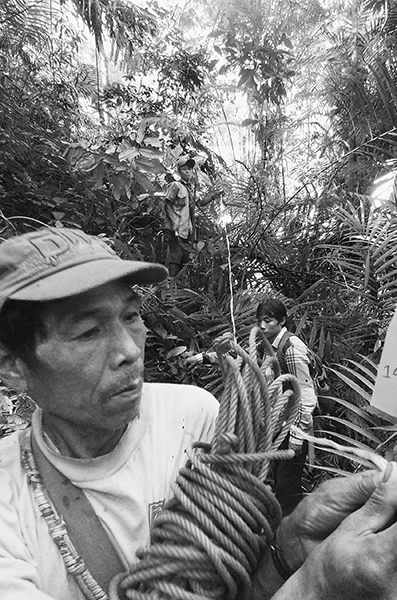
(Opposite) Villagers from Nam Sabi running the baseline to establish a hundred-hectare village management area in the buffer zone of the Htamanthi Wildlife Sanctuary, Sagaing Region, Myanmar.
Forests in the Hukaung Valley and near the villages of Nam Sabi (N25°21´42´´, E95°20´33´´) and Shinlonga (N26°31´13´´, E96°37´34´´) in northern Myanmar, 2009–present
I have always wanted to work in Myanmar. The country contains over half the remaining tropical forests in Southeast Asia and has an astonishing diversity of indigenous ethnic groups. Unfortunately, it was also, until quite recently, controlled by one of the most repressive military regimes in the world; the resident Nobel laureate, Daw Aung San Suu Kyi, who received the Nobel Peace Prize in 1991, had been under house arrest since 1989. The Wildlife Conservation Society (WCS) had been engaged in a tiger conservation project in northern Myanmar for several years, and in late 2003 I called a colleague there and inquired about the possibility of doing collaborative work, particularly on projects in Myanmar that might need botanical, ecological, or forestry advice. His answer opened new vistas of possibilities.
Tigers occur at low densities in the forest, and they are adept at avoiding wildlife biologists. To collect data on tiger population sizes and migration patterns, researchers generally must rely on camera traps, small, remotely activated cameras triggered by a trip line, motion sensor, or light beam. A large number of these traps are set up in the forest, and when a tiger hits the trip line, activates the motion sensor, or crosses the light beam, the camera snaps its picture. After a designated period of time, the researchers revisit the traps to collect the film or memory cards and put fresh rolls and cards in the cameras. When the researchers from the WCS developed the images from their camera traps, they found several shots of tigers—but they also discovered a number of pictures of rattan collectors. These rattan collectors were not only harvesting inside a protected area; they were also a threat to the tiger population. If they saw a tiger, they would undoubtedly shoot it because a dead tiger was worth more than they could make from a year of rattan collecting. My WCS colleague bombarded me with questions about rattan: How many species are there in Myanmar? Can wild populations be managed? Is rattan exploitation compatible with tiger conservation? Clearly it was time to consider a joint project.
The last treatment of the palms of Myanmar had been done in the late 1800s, and few rattan specimens from Myanmar could be found in any of the world’s herbaria, while virtually nothing had been written about the local forests, the non-timber forest resources growing in them, or the indigenous communities that exploit or manage them. A lot of work needed to be done. The camera trap pictures had come from the Hukaung Valley Tiger Reserve, now the Hukaung Valley Wildlife Sanctuary (HVWS), in Kachin State, the largest protected area in Myanmar. Established in 2001, the HVWS extends over 6,300 square kilometers. I made my first trip to Myanmar in 2004, together with my palm botanist friend Andrew Henderson, to set up an expedition to the Hukaung Valley to survey the rattans. We completed the survey in early 2005, discovered a new species of rattan, and came to appreciate that rattan was just one of many forest resources that the communities in the Hukaung Valley depend on. I returned to the Hukaung Valley in April 2009 to do a preliminary resource survey in three villages, and again in December of that year to set up a one-hundred-hectare intensive management area in the forests outside the village of Shinlonga. Shortly after we finished this work, the political situation in Kachin State started to deteriorate and the community forestry work had to be put on hold.
After a four-year hiatus, collaborative community forestry work with the WCS was reinitiated in 2013 in a small village in the Naga Self-Administered Region. This village presented an interesting case study because of its long history of using and managing forestlands that were outside the jurisdiction of the Forest Department. I expanded the community-based natural resource management work in Myanmar during several visits in 2014, collaborating in household surveys, making preliminary inventories in the village of Nam Sabi in Sagaing Region, and helping to set up a one-hundred-hectare management area in the forests outside the village. The Nam Sabi village management area (VMA) is located in the buffer zone of the Htamanthi Wildlife Sanctuary. Because of its location along the periphery of a wildlife sanctuary, the Nam Sabi VMA represents a valuable example of involving local communities in the conservation and sustainable use of protected areas. The policy implications here are huge. I have continued to collaborate with my friends at the Wildlife Conservation Society for over ten years now, and we have accomplished some marvelous things in Myanmar. And it all started with one phone call.
There were twelve of us on the initial rattan survey of the Hukaung Valley in January 2005, including three local botanists, field assistants, and cooking staff. All our bags, tents, cooking equipment, food, and plant presses were loaded into two monster trucks with large knobby tires and an exhaust pipe routed up along the front windshield so that the trucks could cross rivers and sustain water up to the doors without the motor stopping. Six of us crowded in the back of each truck, and alternated standing and sitting (and sleeping) as the trucks slowly worked their way up the Ledo Road to the little town of Namyun on the border with India.1 We crossed several deep rivers along the way without any difficulties thanks to the exhaust pipe.
It started pouring rain soon after we arrived at Namyun. The crew quickly unpacked the trucks and moved our gear into the school building; we set up our tents inside and strung a clothesline to start drying wet clothes. The trucks headed back down the Ledo Road in the rain, and the cooks served us a hot meal by candlelight on the teacher’s desk. Conversation was difficult with the rain banging on the tin roof of the school, but we discussed our schedule for the next six weeks, explained to the local botanists the general plant collecting and inventory methodologies we would use, and speculated as to when the elephants, which were to carry our equipment, might arrive.
The mahouts arrived with their elephants the next day. All the gear that had been in two trucks was transferred to the backs of two elephants and carefully lashed into place. We would walk alongside the elephants for five or six hours until we came to a good place to make camp, then set up our tents and a temporary kitchen.2 We would spend several days at each camp while we explored the local forests, collecting samples of rattans with flowers or fruits, and running inventory transects to document the density and size distribution (number of seedlings, saplings, juveniles, and adults) of local rattan populations. These data can show whether a species is regenerating itself in the forest and periodically establishing new seedlings and saplings or whether the population contains only large adult canes, no seedling or saplings, and will eventually disappear from the forest.
Immediately after returning from the field each day, the botanists would trim their plant collections to fit on herbarium sheets, fold them in newspapers, and stuff them into thick plastic garbage bags. Before tying up the bag, they would pour in several cups of a 70-percent alcohol solution to preserve their specimens. We usually had dinner—rice, vegetables, peanuts, spicy hot tofu—sitting outside on a log or little plastic stools, but if it was raining, we would pile into the kitchen, where the smoke would be so thick that it burned our eyes. People didn’t linger over dinner on rainy nights. The research team would retire to their tents to read or write up their journals, while the kitchen crew washed dishes and the field assistants sharpened their bush knives. The mahouts would untether the elephants and let them forage through the forest during the night. Lying in my sleeping bag, I could hear the bell tied around the elephant’s neck gently ringing as the animal bent down to grab a leaf, the sound growing fainter and fainter as the elephants moved farther into the forest. They would always be back at camp the next morning.
We continued this rhythm—walking, making basecamps, collecting plants, and running inventory transects—for four weeks. When we finally walked out of the Hukaung Valley into the town of Tanai, where we planned to spend several days drying plant specimens at the headquarters of the Tiger Reserve, we had eight garbage bags stuffed with plant specimens reeking of alcohol. We had collected over two hundred specimens, including fifteen species of rattan; eight of the rattan species had never been recorded in Myanmar previously, and one of the rattans was a new species to science and now bears the name of the Hukaung Valley: Calamus hukaungensis A.J. Hend. (Arecaceae). We had run ten transects at different elevations along the Ledo Road and collected quantitative data on the structure of wild populations of twelve rattan species. Some of the commercial species in the reserve occurred at densities of over a hundred harvestable canes per hectare.
In spite of intense commercial harvesting, the rattan populations along the Ledo Road were thriving. Because of the low price offered for the cane, collectors rarely venture more than a kilometer from the road to look for rattan, and owing to the noise, the dust, and the presence of people, tigers rarely come within a kilometer of the road. We concluded that tiger conservation and rattan collection could coexist, and that promoting the management and sustainable exploitation of the latter by local communities would greatly enhance existing efforts to conserve the former. Developing sustainable harvest levels for commercial rattans in the Hukaung Valley, for instance, would ensure that collectors could find sufficient quantities of merchantable cane to exploit near the Ledo Road; they would thus have little incentive to go farther into the forest. Fixed harvest quotas would also help dampen the boom-and-bust dynamics that characterize the markets of many wild harvested resources. Collectors could count on a reliable income from harvesting rattan each year, and their encounters with tigers deep in the forest would become less frequent.
Before heading up the Ledo Road, the kitchen crew had bought plastic cups for everyone on the expedition. They were all different, and mine was white with flowers and a tight-fitting lid for keeping tea hot. I wrote my name, the date, and the location on the bottom of the cup. After driving for several hours, we stopped to stretch our legs and eat lunch at mile 18 camp. We ate curry and drank tea, and talked to the locals about rattan. When we arrived in Namyun, I could not find my cup; I had left it at my host’s house at mile 18. One of the kitchen crew graciously gave me his cup—hot pink with no lid. I was grateful, but disappointed that I had lost my cup on the first day.
The next morning, one of the cooks approached me with a big smile and handed me a blue plastic bag with my cup inside. The woman of the house had noticed that I had left my cup on the table, and she knew that we were headed to Namyun. She gave it to the first motorcyclist who stopped on the way to Namyun with instructions to give it to the group with the American. I have encountered similar instances of careful attention to detail and kindness by the Myanmar people throughout my fieldwork. My overall enthusiasm for community-based approaches to resource management in this country is largely the result of a long series of wonderful interactions with local villagers.
We put together a copiously illustrated report for the Myanmar Forest Department soon after returning from our Hukaung Valley trip and started planning a follow-up project in the tiger reserve. We knew that subsistence communities living inside the wildlife sanctuary depended on the forest for timber, bamboo, and rattan to build their houses, for palm thatch, and for medicinal plants, but we did not know which species they preferred, or how much they used, or what impact the exploitation of these products was having on the forest. Our project proposal was eventually approved, and in May 2009 we conducted preliminary surveys in three villages in the central part of the reserve, Shinlonga, Lajarbon, and Takhet, to get a better idea of what could be achieved with a collaborative community forestry initiative.
We set up a base camp in Shinlonga, a small Kachin community, and conducted household interviews and ran inventory transects at each village. The interviews were usually done in the evenings after the workers had come back from the fields. We would sit around the glow of the cooking fire in the center of the house, and with our flashlight illuminate different sections of the structure—the floor, the walls, the roof joists, the roof—and ask what each was made of, where the material had been harvested, and how long it lasted. It took about half an hour to do the interview and, like people I have encountered all over the world, the inhabitants seemed to enjoy talking about their house, especially if they had built it themselves.
All the houses had thatch roofs, with the cooking fire centrally located inside the house. The underside of the thatch above the fire was always black from the smoke, but the villagers explained that the smoke helped waterproof the roof so it would last longer. Every house had a long bamboo pole leaning against the roof outside with a large square of plaited bamboo tied to the end like a huge flyswatter. This, I was told, was used to put out roof fires, though many houses had a bucket of water handy for the same purpose. Kachin houses require a lot of maintenance. The palm thatch needs to be replaced every three to five years, and the plaited bamboo walls last only about ten years.
Our inventory transects revealed that most of the important timber trees were present in the forest solely as pole-sized individuals, and many of the commercial rattan species had been completely harvested out. But we knew from the household surveys that villagers were not harvesting either of these resources in large quantities. When asked about this, they reported that commercial timber and rattan concessions had been granted in the forest—inside the wildlife sanctuary—and trucks from Tanai had come several times to harvest sawlogs and collect rattan. Many of the Kachin communities had been moved out of the forest to sites along the road so that the Myanmar Armed Forces could “keep an eye on them.” They had been given use rights to the forests surrounding their villages as an incentive to relocate, but several years later, outside concessions had been granted for the same piece of forest. Community forestry would never work as long as it was not clear who had control over the resources.
Good palm thatch was also becoming increasingly hard to find. The preferred roofing material in the Hukaung Valley is produced by the tawhtan palm (Livistonia jenkinsiana).3 The palmate leaves of this species can last up to five years, and the amount of thatch that can be collected from one individual far surpasses that of any other palm. Traditionally, the Kachin would plant tawhtan palms along the perimeter of their rice fields and harvest the leaves as they needed them. Few of the communities had done this since moving to the Ledo Road, and most householders currently harvested thatch from wild palms, whose leaves are less durable and need to be replaced more frequently. Nobody wanted to commit to planting around their fields for fear of being forced to move before they could harvest it.
The socioeconomic conditions in Shinlonga, as well as the ecological conditions in the forest surrounding it, seemed ideal for a program of community-based natural resource management. The community was enthusiastic about the prospect and in late 2009 selected a hundred-hectare tract of forest located about two hours north of the village near a small river for their management area. As with the project I had done previously in Brazil, we would lay out a baseline and then conduct a 10-percent inventory of the entire area using parallel transects. We walked to the management area the first day, but we were so tired by the time we got back to the village that we decided to make a basecamp the next morning. While the cooks saw to that, the field crew and the science staff—U Zaw Lin, U Saw Htun, Rob Tizard, and I—walked directly to the management area and worked on the baseline, clearing the line, tying flags every twenty meters, setting a painted transect post every hundred meters, and obsessively making sure that the line was lying straight. When we arrived, exhausted, at the basecamp site later that afternoon, we found a large, thatch-roofed hut for the field crews, a kitchen with fire pit, and three tents set up next to a beautiful bend in the river. One of them had my pack and sleeping bag inside.
Naw Aung is a Kachin who helped with the forestry work during both my visits to Shinlonga. A major asset in the field, he could identify all the trees, was the first to cut a plot stake or grab a transect rope or start clearing a line, and always had a big smile on his face. He wore an old army shirt, a longyi (a piece of cloth sewn into a cylinder worn around the waist like a sarong), flip-flops, and a large conical hat, and would light up a cheroot whenever he took a break. The handle of Naw Aung’s bush knife cracked once, probably from overuse, while we were laying out the baseline of the management area. He repaired it by the fire that evening using a local rattan,4 and I was not the only person who was mesmerized while watching him do it. He first split the rattan cane and shaved it down to the appropriate thickness. Then he wove a ring of rattan, which he slipped over the cracked handle and pounded into place to close the crack using another piece of rattan. He finished the job by weaving a beautiful rattan sleeve around the handle, and then oiled it using grease from the kitchen. The bush knife was back in use clearing line the next day.
The crews completed all twenty transects in the management area and collected a phenomenal amount of data. We now knew how much timber, bamboo, rattan, palm thatch, and medicinal plants grew in the reserve, and we were able to make contour maps showing the spatial distribution of different resources in the area. These could later be used to establish harvest zones. I put in an order for several thousand stainless-steel springs and a hundred rolls of metal strapping for the growth studies of the timber trees. We were close to establishing the first verifiably sustainable, data-driven participatory community-based forest management project in Myanmar. But something else was happening at this same time—the Kachin Independence Army, the military wing of the Kachin Independence Organization (KIO), a political group of ethnic Kachin who have been fighting for their independence—and more recently their autonomy—since the early 1960s, renewed fighting with the Myanmar Armed Forces, civil war broke out, and all research teams and nonresidents were pulled out of Kachin State.
Four years went by, but the situation in Kachin State remained dangerous and complicated, so we decided to investigate the possibility of doing community forestry work in another location. Tikon, a small village of mixed Naga-Chin ethnicity in the Naga Self-Administered Zone near the border with India was recommended because of its unusual tenure context—the community had lived for a hundred years in a huge tract of forest that was not directly controlled by the Forestry Department.5 It sounded promising so we flew to Mandalay, then took another flight to Homalin, then got on a boat going up the Chindwin River. Six hours later, we got off at Htamanthi and climbed into a truck to drive to mile 25 camp, where there were motorcycles waiting to carry our bags—and maybe us—the final ten miles through the mountain forest to the village. But it started raining and we had to walk because the motorcycles were having trouble getting up the hills. We arrived at the village ahead of our bags—and our dry clothes—just as the rain stopped. The village, consisting of thirteen houses, a church, and a school, was shrouded in fog, a few rays of brilliant sunlight streaming through the clouds. We were at an elevation of over 1,500 meters, the air was brisk, and the Naga Hills and the Indian border loomed in the background. The motorcycles with our bags finally arrived and we pitched our tents in the wood-frame schoolhouse.
In spite of a hundred years of continual use, the montane forests surrounding the village were extremely well preserved—multi-storied, closed canopied, with numerous big trees, understory palms, and tall, looping rattans; our inventory transects were usually accompanied by the raucous singing of Hoolock gibbons (Hoolock leuconedys).6 The traditional territory of the village encompasses over two thousand hectares of forest, and the villagers have managed it well. Hundreds of tall, straight timber trees can be found there, as well as an abundance of good bamboo and rattan canes, and a surprising richness of medicinal plants. With good reason, the villagers worry that someone will take these resources, as well as the forests that contain them, away from them.
We put growth bands on some of the timber trees to see how fast they were growing, and held a village meeting to explain what we had found out in our household surveys and forest inventories. The entire village came to the meeting. We discussed the possibility of developing a community forestry project with the village, and everyone seemed enthusiastic about the idea. We made it clear, however, that this project would involve the intensive management of a small tract of forest, with the objective of developing a management plan and applying on behalf of the village for a community forestry certificate, a permit issued by the Myanmar Forest Department that provides villagers with usufruct rights to specific forest resources, or plantings, or, in selected cases, intact forests. Such a permit would guarantee the villagers the rights to that piece of forest alone. We explained that given the current economic realities in Myanmar, the chances of the community maintaining control over two thousand hectares of resource-rich forest were pretty slim.
My first morning in the Naga Hills, as I sat on the front porch of the schoolhouse writing in my journal, I saw two policemen with automatic weapons and walkie-talkies walking into the village. I scurried inside, and listened to the conversation out in the schoolyard; then the village head took the two men over to his house for breakfast. I found out later that the two policemen had been sent over from the district capital to make sure that the two foreigners (Rob Tizard and I) were “all right.”
The policemen, and their guns, went with us to the field to observe what we were doing. They also participated in some of the tree banding exercises and even put their guns down once to help us make growth bands. A light drizzle was falling the day we walked out of the village back to mile 25 camp, and the red clay on the road was treacherous. I had a walking stick, but I was proceeding with extreme caution as I worked my way down the first slope. One of the policemen came up from behind me and gently took my hand. When we got to the bottom of each hill, and I was no longer in danger of slipping, he would release my hand and drop back next to his partner. He did this every time we had to walk down a hill, for ten miles, all the way back. I never fell. We made brief eye contact after we arrived at mile 25 camp and he gave me a little smile.
Following each of my trips to Myanmar, I would write a detailed report of my activities for the Forest Department. Composing these reports was a useful exercise that enabled me to analyze data and plan the next steps in our community forestry work. I would always include an array of photographs and make the reports as appealing as possible—but I never knew whether anybody actually read them or whether they went straight into a file.
In May 2014, I had the opportunity to go to the capital city, Nay Pyi Taw, and meet the director general of the Forest Department, Dr. Nyi Nyi Kyaw. My visit was mainly a courtesy call; I wanted to thank him for supporting our work over the previous ten years and tell him about what we were currently doing. We had a lovely meeting, and talked about rattan, the importance of botanical exploration, and community forestry. Dr. Nyi Nyi Kyaw said that he was convinced that engaging with rural communities was the quickest, most effective way to promote the conservation and sustainable use of Myanmar’s forests. But such a procedure was unlike the way the Forest Department had operated in the past, and they were still trying to determine how best to move forward with community-based natural resource management. He then casually dropped into the conversation that he had noticed from reading my reports that I had been developing some interesting community forestry prototypes in northern Myanmar. He asked me to keep him informed on how this work was going.
After ten years of fieldwork in northern Myanmar, my WCS collaborators and I had come close to developing a community forestry program for a village located inside a protected area, and we had done preliminary resource supply-and-demand analyses in a community located on forestlands outside of the jurisdiction of the Forest Department. The final land-tenure issue left to investigate was the situation of communities located in the buffer zone of a protected area. These communities have the potential to make a large contribution to conservation. If a program of sustainable forest use could be implemented in the forests surrounding a protected area, and if the community were able to assume control over the forest and stick to the management prescriptions, harvesting the resources they needed for subsistence and perhaps selling a few others to provide a sustainable source of income, the villagers would have little incentive to encroach on the core area of the reserves and poach wildlife. A viable program of community-based natural resource management would, in the words of the director general, “help to lock down the buffer zone and create a sense of stewardship at the village level.”
We found what looked like an appropriate community, Nam Sabi, on the banks of the Chindwin River in Sagaing Region. The traditional territory of this small Shan village extended into the buffer zone of the Htamanthi Wildlife Sanctuary, a two-thousand-square-kilometer wildlife reserve located between the Chindwin and Uyu Rivers. The sanctuary contains tigers, elephants, leopards, and bears. We started working with this village in May 2014, and finished all the preliminary household surveys and forest inventories. We discussed with the community the prospect of setting up a village management area and applying for a Community Forestry Certificate. We found a lot of support for the idea, and on my next trip in early November 2o14 we built a basecamp out in the forest and started laying out a hundred-hectare management area. It took two days to set all the transect stakes along the baseline, and we were able to finish two transects before I left. The remaining eighteen transects were completed by village crews under the direction of U Myint Thein, an extremely capable ranger from the Htamanthi Wildlife Sanctuary with whom I had worked on two previous trips. Not only did the field crews finish all the transects, but they finished before the end of November in time to harvest their rice fields. They also put growth bands around eighty-two timber trees to start growth studies.
The community forestry work in Sagaing Region has surpassed the work that was interrupted five years ago in the Hukaung Valley. The site and context are different, but the underlying concept is the same—balance the local supply and demand for forest resources at the community level through the sustainable harvest and participatory management of a small tract of forest. A lot of enthusiasm exists at the village level to make this work, giving me a strong feeling that a new story about people and plants and tropical forests is being born here.
When we finished running the first transect in the Nam Sabi management area, it was about 2:00 p.m. and past time for lunch. We were close to a large stream that ran through the area, and the smooth, sandy beaches seemed perfect for a picnic. We hiked over to the river and had a delightful lunch, relaxing, talking about the transect we had just finished, and marveling at the beauty of our lunch spot. The next day, when we finished transect two, we decided to walk back to the river where we had had lunch the day before. Clearly outlined in the damp sand, fresh from the night before, we saw tiger tracks. I am sure the tiger had smelled us. I have never wanted to meet a tiger in the forest, but I feel deeply honored to have shared a resting spot with one.