The first spur trail descends to Sunrise Lake.
36 Palisades Lakes
A sharp descent into a valley graced with meadows, wildlife, and a string of lovely lakes.
Start: Palisades trailhead
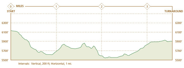
Distance: 7.0-mile out-and-back
Hiking time: About 4–5 hours
Elevation gain: 700 feet (return trip)
Difficulty: Moderate
Best season: Mid-July through Sept
Nearest town: Greenwater
Fees and permits: Vehicle or individual entry fee (7 days); annual entry pass available for purchase; wilderness camping permits free—reservations (for a fee) recommended
Maps: USGS White River Park; Trails Illustrated Mount Rainier National Park; Earthwalk Press Hiking Map & Guide
Trail contacts: White River Wilderness Information Center, (360) 569-6670
Trail conditions: www.nps.gov/mora/planyour visit/trails-and-backcountry-camp-conditions.htm; weather, www.nps.gov/mora/planyour visit/weather.htm
Finding the trailhead: From the White River Ranger Station (see Getting There), continue 11.0 miles on Sunrise Road to well-marked Sunrise Point. GPS: N46 55.063' / W121 35.251'
The Hike
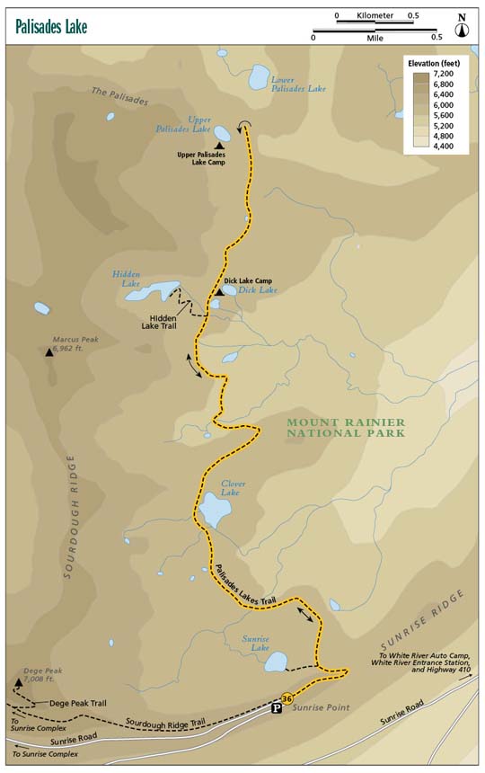
After parking at Sunrise Point, cross Sunrise Road to the east. The trail begins at the easternmost corner of the point beyond a few informational displays. At first the trail descends gradually, but the slight grade soon gives way to a steep, rocky trail. Wear shoes with good traction. We saw more than one person in inadequate footwear slip on the dusty trail. The steep switchbacks end in 0.5 mile at a junction. The westbound trail heads to Sunrise Lake, a pretty lake that lies unfortunately close to a busy road.
To continue toward Palisades Lakes, stay to the right (north). The next mile to Clover Lake is almost completely flat. You walk alternately through forest and meadow. When the forest opens to reveal a lake, you have reached Clover Lake. You cannot camp here, but it makes a lovely spot for a break. Stay on the maintained trails—the terrain encircling Clover Lake is very fragile.
Immediately north of Clover Lake, the trail climbs a low ridge. The ascent is not long, but it is steep. From the top of the ridge, it’s all downhill or flat to the junction with the Hidden Lake Trail, 2.6 miles into the hike. (See Option.)
The first spur trail descends to Sunrise Lake.
If you do not plan to take the Hidden Lake option, stay to the right (north) on the main trail. Another 0.3 mile of trail takes you to Tom, Dick, and Harry Lakes and to Dick Lake Camp. If you plan to stay at Dick Lake Camp, follow signs for Dick Lake, a short trek through the woods. Situated in forest, these green lakes are filled with grass. In midsummer beware of the bugs; mosquitoes thrive here.
Mosquitoes are also abundant at Upper Palisades Lake. When we were here, one of the backpacking groups abandoned camp because of the bug infestation. Infestations vary by year and depend on seasonal factors as well, but be forewarned. To get to Palisades Lakes, stay to the north on the main trail. A very slight ascent leads you first through forest, then field. When you reach a large emerald meadow that “resembles a golf course,” as a ranger told us, turn around. From this spot you have a nice view of the Cowlitz Chimneys over rolling green hills.
Beyond this meadow, it is less than 0.5 mile to Upper Palisades Lake. The trail stays relatively flat until you reach the fork to Upper Palisades Camp. To head toward the camp, take the trail to the left (southwest). To filter water from the lake, take the path straight down to the lake (west). To see Lower Palisades Lake from a distance, stay on the main trail (north).
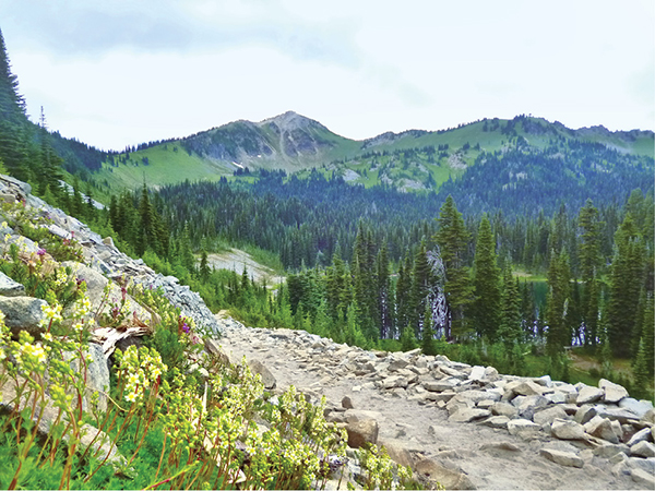
Upper Palisades Lake is beautiful. From the direction you approach, a field of flowers leads all the way to the water’s edge. Striated rock formations, the Palisades, provide the backdrop for the deep-blue and aqua waters of the lake. If you planned only a day hike, retrace your steps along the main trail.
 The word palisades was originally used to describe a defensive fence made of sharpened wooden stakes of varying heights.
Miles and Directions
0.0Start heading east on the Palisades Lakes Trail from the easternmost tip of Sunrise Point.
0.5At the spur trail to Sunrise Lake, stay to the right (north) toward the more private Palisades.
1.5Clover Lake appears on your right (east). Stay on the main trail, and mind the fragility of the meadow.
2.6Reach the Hidden Lake Trail junction. Be sure to take this side trip!
2.9Tom, Dick, and Harry Lakes rest to your right; Dick Lake has a camp to offer.
3.5Whether or not you plan to camp there, take the trail to the lovely Upper Palisades Lake. Though rather anticlimactic, you can stay on the main trail for less than a mile to catch a glimpse at Lower Palisades Lake before returning the way you came.
7.0Arrive back at the trailhead.
Option: Don’t miss the side trip to Hidden Lake. At the junction, 2.6 miles into the hike, turn left (west). A steep, dusty 0.6-mile ascent with a few switchbacks leads to a lovely lake. In a glacial cirque, the cool waters of the lake are surrounded on three sides by jutting rocks. A maintained trail runs around a large peninsula and stops abruptly. Although some social trails have been created around Hidden Lake, stay on the main trail. The Park Service is working to restore the soil and vegetation in this area.
Wilderness camping: You have two options for backcountry camping: Dick Lake and Upper Palisades Camps. Dick Lake Camp, the less-desirable of the two, is situated in a place that requires a hike to reach both the toilet and the lake. Upper Palisades Lake has two very nice sites.
Hike Information
Local Information
Sunrise Visitor Center, (360) 663-2425
Mount Rainier National Park website, www.nps.gov/mora; twenty-four-hour visitor information, (360) 569-2211
Lodging
National Park Inn and Paradise Inn Reservations, (360) 569-2275. For more information on the two inns located within Mount Rainier National Park or to book either inn online, visit www.mtrainierguestservices.com.
For links to accommodations outside the park, visit www.nps.gov/mora/planyourvisit/lodging.htm.
Campgrounds
If you plan to car camp, the nearest facility in the park is White River Campground, located 5.0 miles beyond the White River Entrance Station. You can claim one of the 112 sites on a first-come, first-served basis. If you do not want to risk the chance that White River Campground is full, you can reserve a campsite at another campground in the park or the surrounding national forest online at http://reservations.nps.gov, or by calling (877) 444-6777 (10:00 a.m. to midnight EST).