
Named for the black rock debris that protect the glacier from retreating at a faster pace, close up views of Carbon River occur just a few paces beyond the suspension bridge.
53 Carbon Glacier and Moraine
A moderate ascent to the snout of the Carbon Glacier, the lowest-elevation glacier in the contiguous United States, this hike travels along the glacier, allowing you to witness many of the geological processes associated with glaciers. Among other things, you will see the rock debris that has been shattered from the rock walls surrounding the glacier and deposited atop the massive river of ice, coloring the glacier brown and black.
Start: Carbon River trailhead
Distance: 17.6-mile out-and-back
Hiking time: About 8–10 hours
Elevation gain: 1,700 feet
Difficulty: Moderate overnighter; strenuous day hike
Best season: Mid-July through Sept
Nearest town: Wilkeson
Fees and permits: Vehicle or individual entry fee (7 days); annual entry pass available for purchase; wilderness camping permits free—reservations (for a fee) recommended
Maps: USGS Mowich Lake and Sunrise; Trails Illustrated Mount Rainier National Park; Earthwalk Press Hiking Map & Guide
Trail contacts: Carbon River Ranger Station, (360) 829-9639
Trail conditions: www.nps.gov/mora/planyour visit/trails-and-backcountry-camp-conditions.htm; weather, www.nps.gov/mora/planyour visit/weather.htm
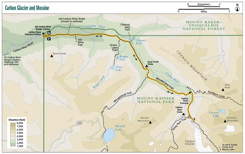
Finding the trailhead: From Wilkeson, drive south on WA 165 for 9.0 miles to where the road forks. Turn left (southeast) onto Carbon River Road; if you start to ascend a big hill, you have missed the turn. Follow the Carbon River Road along its flat course alongside the river for 6.0 miles until you see the Carbon River Ranger Station. The Carbon River Entrance Station lies 2.0 miles beyond the new ranger station, where the road closes. The road closure marks the Carbon River Trailhead. GPS: N46 59.690' / W121 54.898'
The Hike
From the Carbon River trailhead, walk or bike 5.0 miles east along the Carbon River Road, bypassing the Old Mine Trail at 1.2 mile and the Green Lake and Ranger Falls Trail at 3.0 mile, until you reach the Ipsut Creek Campground. Formerly a car campground, Ipsut Creek has vast facilities for a wilderness camp, including many tent sites, bear lockers, and outhouses. You may choose to set up camp here and approach Carbon Glacier as a day hike.
From the Ipsut Creek Campground, follow the old Carbon River Road to its southern terminus, where it intersects with the Wonderland Trail. The Ipsut Falls spur trail intersects to the right (west) shortly after you leave Ipsut Falls Campground. If you desire, take this spur trail to gently cascading Ipsut Falls just steps off the main trail. Back on the Wonderland Trail, you continue southeast until the trail splits. Stay to the left (southeast), hiking toward Carbon Glacier and the Yellowstone Cliffs. The trail ascends very gently for the first couple of miles. Watch for signs of wildlife on this section of trail; we were greeted by massive bear scat and darting snakes.
Named for the black rock debris that protect the glacier from retreating at a faster pace, close up views of Carbon River occur just a few paces beyond the suspension bridge.
Two miles beyond the split, you reach a sign that directs you down to the riverbed. (The Wonderland Trail once continued on its path on the west side of the river to a suspension bridge a mile uphill, but after severe washouts in 2006, the trail now cuts across the river at this point and up the more stable east bank.) Cross several footlogs and take in the brief glimpse of Mount Rainier over the flour-filled waters. We recommend you call in advance to ensure the footlogs are in place, unless you don’t mind fording an unpredictable river. Once on the east bank of the river, you reach the intersection with the Northern Loop Trail. Turn right (south), continuing toward the Carbon River’s headwaters.
You travel at a nicely rolling uphill grade in the shade of large fir trees for 1.2 miles when you see some large boulders and signs for a suspension bridge on your right (west). This bridge offers a fantastic view of the Carbon River below, go ahead and take a moment to experience the vista. Once you have had your fill, continue your ascent toward along the moraine. The easy grade gives way to a steep pitch. The trees open up to reveal the Carbon Glacier, nestled in its moraine with Mount Rainier’s shoulders just in view above it. Rubble and debris litter the blue ice of Carbon Glacier. Do not be surprised to hear the echoing crashes of falling rocks.
With a thickness of 700 feet and a volume of 0.2 cubic mile, the Carbon Glacier claims the greatest measured thickness and volume of any glacier in the contiguous United States. Although Carbon Glacier is currently retreating, as recently as the 1970s park visitors reported witnessing the glacier actively advance and crush vegetation caught in its path.
If you want the full experience of Carbon Glacier, you may choose to stay the night at Dick Creek Camp, perched above the moraine just 0.7 mile up the trail. Regardless of your camping plans, spend some time here admiring the Northern Crags over the Carbon Glacier. If you have time, we strongly recommend venturing to Moraine Park, which boasts breathtaking views of Mount Rainier in her full grandeur above perfect subalpline meadows (see Options). If you’re short on time, follow the same trail back to Ipsut Creek Campground.
 Glaciers, like Carbon Glacier, are really moving rivers of ice. They advance when snow accumulates faster than it melts. The weight of the snow squeezes the air out, packs down the snow, and compresses the glacier into ice. Even when the summer snowmelt exceeds the winter snowfall, causing the terminus of a glacier to recede, the main body of the glacier always continues moving downhill. As glaciers travel, they displace rock debris and carve out U-shaped canyons. Frequent frosts burst the waterlogged rock walls along the glacier. These bursts cause large rocks to break away and join the glacier.
Miles and Directions
0.0Start at the Carbon River trailhead, heading east along the old Carbon River Road from the entrance station.
1.2The Old Mine Trail enters the forest on your right (south). Unless you want 0.25 mile of steep climb to peer into a gated mine shaft, stay on the road toward Ipsut Creek Camp.
3.0The Green Lakes and Ranger Falls trailhead appears to your right (southwest). You may leave your packs at the trailhead and explore these features or move on toward the campground.
3.5A small sign marks the trailhead to Chenuis Falls, a lovely sliding waterfall just across the Carbon River. Check out the falls if you like, or continue on the main road toward Ipsut Creek.
5.0The road rounds a final bend, crosses a bridge, and spits you out at Ipsut Creek Campground. Either camp here or follow the road to its end, where the Wonderland Trail begins.
5.2A spur trail to Ipsut Falls presents itself on the right (west). Continue south (left) on the trail to the junction with Wonderland Trail. At the junction go southeast on the Wonderland Trail.
7.0Turn left (northeast) and descend to the riverbed to cross Carbon River over several footlogs.
7.3Stay right (south) at the junction with the Northern Loop Trail, and continue heading upstream.
8.5A suspension bridge comes up on your right (west). We encourage you to walk to the center of the bridge for a bird’s-eye view of Carbon Glacier. Mind the weight and occupancy limits of the swinging bridge!
8.8In case you did not notice the huge mass of ice covered with dark rock with a river flowing from its snout, a sign indicates that you have reached Carbon Glacier. The view gets even better a little ways up the trail. When you have finished exploring the area, return along the same path.
17.6Arrive back at the trailhead.
Options: Many options present themselves on the hike to Carbon Glacier. After walking 3.0 miles along the Carbon River Road, you may choose to drop your packs and climb to Green Lake and Ranger Falls. This option would add 2.0 miles round-trip to Ranger Falls and 3.2 to Green Lake. At 3.5 miles into the hike, you can descend into the Carbon riverbed, cross to the east bank and investigate Chenuis Falls, a 0.8-mile round-trip excursion. After you reach Carbon River, you may feel inspired to press on, and venture into Moraine Park, which lies 2.5 miles and 2,000 feet uphill from the sign for Carbon Glacier, adding 5.0 miles to your round-trip total.
Wilderness camping: If you plan to backpack, you have three options in the way of camps: Ipsut Creek, Carbon River, and Dick Creek. Formerly a car camping destination before the permanent closure of the Carbon River Road, Ipsut Creek Campground still has the feel of its original purpose. The twelve individual sites and one group site are well spaced along a road-like loop with parking spaces and bear lockers at the entrances. Enclosed toilets stand near the Wonderland trailhead. Ipsut Creek is a cushy launching pad for long day hikes into more remote areas. Carbon River Camp, nestled in old-growth forest, sits just across the suspension bridge on the west bank of the Carbon River. There are four individual sites and one group site. The water source for this camp is Cataract Creek, a good 0.1 mile from all the sites. Although small alder trees have taken root in the rocky soil around Dick Creek and obscured the once-panoramic view of Carbon Glacier, the camp, just 0.7 mile up from the sign announcing Carbon Glacier, remains comfortable and coveted. Two nice individual sites welcome campers and Dick Creek offers clear-flowing water just down the trail.
Hike Information
Local Information
Mount Rainier National Park website, www.nps.gov/mora; twenty-four-hour visitor information, (360) 569-2211
Mount Baker Snoqualmie National Forest, www.fs.usda.gov/mbs
Lodging
For links to accommodations outside the park, visit www.nps.gov/mora/planyourvisit/lodging.htm.
Campgrounds
For no fee, Mowich Lake Campground, at the end of Mowich Lake Road, also offers walk-in campsites on a first-come, first-served basis. Campfires are prohibited.