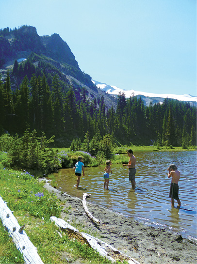
A family frolicks in the cool waters of Mystic Lake.
63 Wonderland Trail
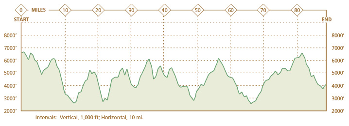
This spectacular, more than 90-mile loop completely encircles Mount Rainier, presenting a challenge to the ablest hiker and a comprehensive taste of Mount Rainier. This hike involves dramatic elevation changes, taking you from the calm of old-growth forests to the openness of subalpine meadows with breathtaking views of Mount Rainier.
Start: Mowich Lake
Distance: 90.8-mile loop
Hiking time: 9–14-day extended backpack
Difficulty: Strenuous
Season: Mid-July through Sept
Nearest town: Wilkeson (unless you choose another start point)
Fees and permits: Vehicle or individual entry fee (7 days); annual entry pass available for purchase; wilderness camping permits free—reservations necessary for the Wonderland Trail (for a fee)
Maps: USGS Golden Lakes, Mount Rainier East, Mount Rainier West, Chinook Pass, White River Park, Sunrise, Mowich Lake, and Mount Wow; Trails Illustrated Mount Rainier National Park; Earthwalk Press Hiking Map & Guide
Trail contacts: Longmire Wilderness Information Center, (360) 569-6650; White River Wilderness Information Center, (360) 569-6670; Carbon River Ranger Station, (360) 829-9639
Trail conditions: www.nps.gov/mora/planyour visit/trails-and-backcountry-camp-conditions.htm; weather, www.nps.gov/mora/planyour visit/weather.htm
Finding the trailhead: From Wilkeson, drive 9.0 miles south on WA 165 until the road forks. Stay to the right (south) at this fork, the way to Mowich Lake. After 3.2 miles the road turns into a well-maintained dirt road, although it can be very slippery when muddy and a dusty washboard when dry. Follow this road for another 8.8 miles to the Paul Peak trailhead on the right (south) side of the road. Pause here to pay the entrance fee at the fee station, and continue south and east 5.3 miles to Mowich Lake, a total of 26.3 miles from Wilkeson. The parking lot is fairly big, but on sunny weekends you might have to park along the road. GPS: N46 55.951' / W121 51.799'
Special considerations: Historically, the western part of the park experiences numerous washouts due to glacial outburst floods. Footlogs across rivers or streams originating from glaciers frequently wash out. The National Park Service does not advise fording glacial rivers due to the high concentration of debris and the risk of large glacial boulders in the water. If you must cross, the Park Service recommends crossing early in the day and using fallen logs that span the channel. Try to choose a large tree with bark for traction—and use extreme caution! Also, always wear your boots to protect yourself from any debris suspended in the river.
Do not filter water from creeks or rivers cloudy with glacial silt, called glacial flour, suspended in them; it will ruin your filter. Bring iodine tablets and an extra filter along in case your filter fails.
The Hike
From the Mowich Lake parking lot, locate the trail that runs along the west side of Mowich Lake. There are several paths down to this trail; continue heading north on the only trail that runs north-south along serene Mowich Lake. You are already on the Wonderland Trail. The first 0.5 mile continues along Mowich Lake and then slopes gently uphill to the top of Ipsut Pass. Near the top of Ipsut Pass, the Tolmie Peak Trail splits left (west). Stay right (northeast) on the Wonderland Trail.
The first 0.5 mile down Ipsut Pass is very steep and open with salmonberry bushes lining the path. You can see Castle Peak to your right (east) above the pass. After 0.5 mile of steep descent, the trail levels out and heads into the cool forest. The trail continues downhill for about 3 miles until you reach the spur trail to Ipsut Creek Camp. You will cross several clear streams on the descent, in case you need to filter water. If you reserved a site at Ipsut Creek Camp, you have reached your first destination. Otherwise, continue along the Wonderland Trail toward Carbon River or Dick Creek Camp.
The next couple of miles climb gently along the Carbon River, which runs cloudy from an abundance of glacial silt. Do not try to filter this water; it will ruin your filter. Many clear tributaries are a preferred option. As the trail opens up, the hulk of black stone above you is the north side of Mother Mountain. Notice the gigantic bear scat, the devil’s club, and the darting snakes. Soon, you reach a sign indicating that the trail along the west bank is permanently closed. After the floods of 2006, the Wonderland Trail was rerouted across the Carbon River bed. Descend into the riverbed and cross the Carbon River over footlogs. On the other side, the trail splits. Follow the Wonderland Trail to the right (south) toward Carbon Glacier, the headwaters of the Carbon River. After 1.2 miles, you reach a suspension bridge over Carbon River. If you reserved a site at Carbon River Camp, cross the bridge—admiring Carbon Glacier—and find the camp to your right (north). Otherwise, continue along the Carbon Glacier Moraine. Bushes line the trail along the river, and in August the thimbleberries are ripe for the picking. Unobstructed views of the massive Carbon Glacier lie only 0.4 mile upstream. The easy grade gives way to a steep pitch. Rubble and debris carved from the earth litter the blue ice of the Carbon Glacier. Do not be surprised to hear the echoing crashes of falling rocks as chunks of the glacier fall off into the silty waters below.
With a thickness of 700 feet and a volume of 0.2 cubic mile, Carbon Glacier claims the greatest measured thickness and volume of any glacier in the contiguous United States. Although Carbon Glacier is now in retreat, as recently as the 1970s park visitors saw the glacier actively advancing and witnessed it crush vegetation caught in its path.
Beyond the suspension bridge over Carbon River, the trail becomes exposed and dusty. You climb steadily along the rocky moraine with awesome views of Carbon Glacier all the way to Dick Creek Camp. Although Mount Rainier is obscured at this point, you can see the Northern Crags above the glacier. Admire the open view while you have it, because after Dick Creek Camp the only view you will have is the next, ever-steeper switchback for upwards of 2 miles. Finally, the landscape opens and the grade lessens as you begin to skirt Moraine Creek.
Beyond the streambed you come to a rock field, then into the fields of Moraine Park. On a sunny summer day, the mountain tops off your view of this large meadow dotted with colorful wildflowers. At this point you have only two relatively small hills to climb before beginning the descent to Mystic Lake. The lake rests in a valley between Mineral Mountain and the appropriately barren-looking Old Desolate. The beautiful view, however, cannot be seen from Mystic Lake Camp, 0.2 mile down the trail, but you can glimpse one of the best views of the mountain from the front porch of the Mystic patrol cabin. Keep in mind that you are in bear country. Local rangers confirmed the presence of a resident sow at Mystic Lake, and bear scat abounds on and around the trail all the way from Ipsut Creek Camp to Mystic Lake. If staying here, take all precautions and make sure you hang your food and toiletries with extra care.
A family frolicks in the cool waters of Mystic Lake.
The next established camp, Granite Creek Camp, is only 4.0 miles beyond Mystic Lake Camp, but in order to get there you must circumvent the Winthrop Glacier. After leaving the cozy subalpine forest near Mystic Lake, an easy 1.0-mile descent skirts the Winthrop Glacier, leading to Winthrop Creek. Cross the prepared log to the other side, and begin to climb your final big hill before reaching Sunrise. Hike 2.0 miles uphill with a few sporadic switchbacks to Granite Creek Camp. These 2.0 miles run along the Winthrop Moraine, providing an excellent glimpse of the glacier, before turning west toward forest. If you plan to pass the camp and move on toward Sunrise, stay on the Wonderland Trail, heading east through camp.
Less than 2 miles of nicely graded, long switchbacks lead to a saddle below Skyscraper Mountain, with views in all directions. You can see several trails convening and converging. More than 20 miles into your hike, you come to the Northern Loop junction. However tempting this 33.0-mile hike may be, you have your own loop to worry about: Stay on the Wonderland Trail toward Sunrise. In almost a mile you reach the junction of five trails near Frozen Lake. Signs clearly point you east and then southeast toward Sunrise Camp. If you need to go the Sunrise Ranger Station to get supplies or devour some decadent fries at the snack bar, you may want to take the Sourdough Ridge Trail for the best views. Otherwise, head downhill toward Shadow Lake and Sunrise Camp.
The trail heading east, to your left, is somewhat of an administrative road. Instead of taking this road to the Sunrise Complex, head right (south) and travel until you reach Sunrise Camp. From Sunrise Camp you must take the Sunrise Rim Trail to the Wonderland Trail. The Sunrise Rim Trail begins to the south of the camp, heading east toward Shadow Lake. The trail wraps around Shadow Lake, heads east then starts down toward the White River Campground. The Emmons Vista and Silver Forest Trail splits off from the Wonderland Trail just before you begin your descent. Stay to the right (south), or you may end up on a dead-end trail amid windblown firs. You leave the alpine meadows of Sunrise for the shade of the fir and cedar forest as you snake down to the river.
More than 3 miles of steep, downhill switchbacks bring you to Loop D of the popular White River Campground. Walk either way around Loop D to the other side, marked by a large picnic area with a fantastic view of Mount Rainier and White River. Look for a sign that marks the resumption of the Wonderland Trail, and start down toward the river. Cross the river over several hatched logs and bridges, and then enter the forest. The trail remains relatively flat for the next 2.7 miles to the Fryingpan Creek Trail junction. Ignore any intersecting trails to the road to Sunrise and the sound of cars zooming along until you come to the intersection with the Fryingpan Creek Trail. At this intersection stay to the right (south), following the Wonderland Trail.
Heading south from the Fryingpan Creek Trail junction, the trail climbs gradually through woods. A few switchbacks indicate that you are nearing the Fryingpan Creek crossing. Just beyond the creek you enter a gap in the forest that allows for a good glimpse of Mount Rainier. The trail then gets steeper. When the trail turns south, you have only 1.0 mile of switchbacks to go until you reach Summerland, nearly 32 miles into the hike. In the Summerland area you stand in fields of wildflowers with a fantastic view of Mount Rainier and Little Tahoma atop her shoulder, the rocky holdout from a massive explosion.
After the trail crosses the water source for Summerland Camp, the fields of subalpine flowers give way to rock field—you are entering alpine terrain. The mountain looms over you as you pass an iceberg lake and Panhandle Gap, a saddle between two rocky rises. At this point you have reached the apex of the entire length of the Wonderland Trail.
 Mowich, the name of the largest lake in Mount Rainier National Park, is a Native American term for deer.
In this area, snow is a constant. Prepare to cross several steep and slippery snowfields, even in the heat of late summer. Route finding in this area may prove very difficult in bad weather. As you descend along a ridge flanked by cliffs and falls on one side and a flowered valley on the other, you have just 1.5 miles to go before you reach Indian Bar Camp. Many switchbacks lead down to a mountain meadow covered with lupine and magenta paintbrush. The Indian Bar Shelter is across the meadow. If you are camping here, follow the sign that points left (east) to an available site. Otherwise, continue south along the main trail.
From Indian Bar the trail climbs steadily, gaining 1,000 feet to the top of a mountain known colloquially as “5930,” its total elevation. Make sure you look behind you, because you once again have a great view of Mount Rainier. The top of the knoll makes for a good photo opportunity if the weather cooperates. The descent from the top leads to a wooded ridge, eclipsing Mount Rainier. Walk along this ridge, the Cowlitz Divide, 3.0 miles to a fork in the trail.
At the fork head right (southwest) toward Nickel Creek. Bloodthirsty mosquitoes frequent the snowfields in this area in midsummer, so come prepared for the onslaught. Soon after taking the Wonderland Trail toward Nickel Creek, you leave any remaining snowfields, descending quickly along steep switchbacks. The trail flattens as you approach Nickel Creek Camp, 2.0 miles beyond the intersection to the Cowlitz Divide Trail. If you do not plan to stay here, follow the Wonderland Trail around the camp. You cross a small stream before crossing Nickel Creek along a prepared log. Only 0.9 mile more of gradual downhill and you come to Box Canyon.
Stay to the right (northwest) along the small Box Canyon Loop. Years of glacial erosion have smoothed the surfaces of these rocks. Plants struggle to survive. You soon come to the bridge over the Cowlitz River. Water churns below. The trail almost immediately forks beyond the bridge. Stay to the right (southwest) along the Wonderland Trail. The trail ascends a bit before crossing Stevens Canyon Road over a tunnel. Less than 1 mile from the road crossing, you come to the Stevens Creek Trail junction. Stay to the left (west), once again along the Wonderland Trail. Cross the bridge where Stevens Creek churns over gray, black, and turquoise boulders.
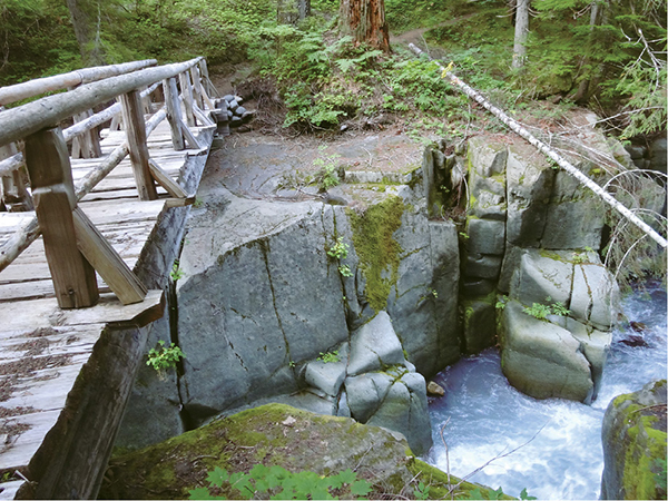
A falls churns under the bridge crossing Stevens Creek.
In 1903 army engineer Eugene Ricksecker was working on the road from Longtime to Paradise. His boss suggested creating a 100-mile loop of the mountain to reach the “snout of each glacier . . . in turn,” but the Mountaineers objected. It was agreed that the north side of the mountain would remain roadless.
Another mile of hiking on relatively flat terrain brings you to Maple Creek Camp. Reaching Maple Creek Camp, 46.4 miles from where you began, means that you have traveled more than halfway around the Wonderland Trail. Unless you want to explore campsites or use the pit toilet, stay to the right (northwest) toward a deceptively narrow part of the trail. The trail will widen and cross a stream along a small log. While crossing, look up and to your left to see Maple Falls, which you may find difficult to spot as a result of its distance from the path.
Sylvia Falls, less than 1 mile beyond Maple Falls, is obscured by large trees, but what is visible is engaging. It appears as though the water shoots directly out of the land from no source. A small clearing that looks out upon Sylvia Falls makes a nice, cool lunch spot for summer hikers.
A gradual ascent begins here and continues 1.0 mile to Martha Falls, the most impressive of the five falls on this stretch, if just for its size. The gradual ascent soon becomes a steep ascent for 0.7 mile of switchbacks. The sound of cars tells you that you are near Stevens Canyon Road. The trail continues directly across Stevens Canyon Road.
The ascent continues for 1.0 mile before you catch sight of Louise Lake through the trees. If you would like a closer look, follow the marked and maintained trail to the sandy beaches of Louise Lake. Park rangers report decent fishing here. Permits are not required to fish in the national park, and there are no limits on most fish, but you must know your protected species. After you’ve had your fill of the lake, continue along the main trail, which widens—a sign of more frequent use. A more gradual ascent leads to the junction with the Lakes Trail. Turn left (south) to once more encounter Stevens Canyon Road.
When you reach Reflection Lakes, the trail ends. You must hike 0.1 mile along the road until the trail resumes on the far (west) side of the lakes. Stay on the trail until you cross Stevens Canyon Road and are on the Wonderland Trail again. The trail slopes down and then slightly up to the beginning of a set of downhill switchbacks. It is 1.3 miles from Stevens Canyon Road to the junction with Narada Falls Trail.
We recommend hiking the short jaunt to the glistening waters of Narada Falls before continuing on the Wonderland Trail. Go right (north) less than 0.1 mile to view the falls, or go left (southwest) if you are too tired or in a hurry. You will hear the Paradise River flowing directly to your right and will soon cross it. You will pass Paradise River Camp on your left, a little over 0.5 mile from the Narada Falls Trail.
Three bridges take you over the relatively calm forks of the Paradise River. About 0.5 mile from here is Madcap Falls, where Tatoosh Creek flows into the Paradise River. Instead of dropping straight down, Madcap Falls flows at a diagonal. The water gushes over the rocks to create an amazing white wonder.
Carter Falls is 0.2 mile after Madcap Falls. A sign reaffirms that the gorgeous waters you see dropping straight down are in fact Carter Falls. You might come upon a number of people here, considering the proximity to Cougar Rock Campground.

The view of Mount Rainier and Little Tahoma from Summerland Camp.
The next 1.1 miles are a pleasant walk along the Paradise River. The large pipe seen along the trail is a historic wooden water supply pipe made of cedar wood and steel support rings that once fed water to an old, now-dismantled hydroelectric power plant. The pipe parallels your path to the Nisqually River basin, where a set of bridges and footlogs cross its waters. Nisqually River originates from active glaciers that deposit silt and grind glacial flour into the river—making the water extraordinarily cloudy. The wide, pebbly Nisqually River valley is scattered with debris and downed trees from previous floods.
After you cross the bridges, climb up to the Longmire-Paradise Road. Wonderland Trail continues to your left (southwest). In less than 0.25 mile, you come to another junction. The trail to your right (north) goes to Cougar Rock Campground; the old horse ford for the Nisqually River is to the left. Continue heading southwest on the Wonderland Trail until you reach a junction. To go to the Longmire Historic District, go left (west); otherwise, go right (north). You will cross Longmire-Paradise Road 0.1 mile after this junction. Wonderland Trail continues on the other side of the road, heading north up to Rampart Ridge.
You are about to begin the part of the Wonderland Trail coined “the piecrust” due to the extreme elevation changes. Be prepared for steep elevation oscillations. After traveling for 1.6 miles from Longmire-Paradise Road, you come to the junction with the trail to Van Trump Park, heading east. Stay to the left, heading north, and arrive at the junction with the Rampart Ridge Trail in just 0.2 mile. The next mile to Kautz Creek is relatively level and a break from the uphill. Due to continual washouts, Kautz Creek has been recently rerouted, but you might still have to ford this river.
On the other side of Kautz Creek, the trail ascends to Pyramid Creek Camp, 0.7 mile away. The trail continues steeply, taking you through dense forest all the way to Devil’s Dream Camp. After Devil’s Dream Camp the trail continues uphill, but it is not as steep. You pass Squaw Lake about 0.3 mile from Devil’s Dream Camp. The Kautz Creek Trail junction, in the center of Indian Henry’s Hunting Ground, is 0.8 mile away.
Iron Mountain and Copper Mountain are visible to the right of the trail as you head toward the picturesque meadows of Indian Henry’s Hunting Ground. This area was named for Indian Henry (Sutelik), a Native American who taught James Longmire about the trails in Mount Rainier. Indian Henry’s Hunting Ground is filled with lupine and a variety of other colorful flowers in August. On a clear day you have fantastic views of the southwest side of Pyramid Peak and Mount Rainier, as well as the Sunset Amphitheater.
Mount Rainier’s oldest patrol cabin, still in use, appears to the right of the trail, nestled in the meadow just after you pass the Kautz Creek Trail on your left (southwest). The trail is relatively level as it travels through Indian Henry’s Hunting Ground. You will pass the Mirror Lakes Trail on your right (northeast) 0.2 mile beyond the Kautz Creek Trail.
After the Mirror Lakes Trail, the trail begins to descend to Tahoma Creek. This part of the trail has steep switchbacks and travels through pleasant forest to the suspension bridge, 1.5 miles from the Kautz Creek Trail. From the suspension bridge there is an amazing view of Tahoma Creek. If it is not too windy, take the time to look up the creek. Tahoma Creek continually experiences glacial outburst floods. If you hear a loud, roaring sound, immediately head to higher ground.
Just after you cross the suspension bridge, look for a sign for Tahoma Creek Trail on the right, heading west. The Tahoma Creek Trail connects with Westside Road in 2.1 miles. As the sign indicates, the trail is not recommended for use. The Wonderland Trail takes off uphill at this point and travels up steep switchbacks until it leaves the forest. You will hike over the South Tahoma Moraine as you head up to Emerald Ridge.
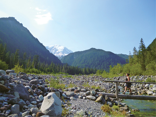
The Nisqually River basin affords stunning views of Mount Rainier, weather permitting.
Puyallup (pyoo-AL-uhp) is composed of two Native American words—pough, meaning “generous,” and allup, meaning “people”. The Puyallup Tribe was known to be fair and honest traders with other Native Americans.
The top of Emerald Ridge is an emerald-green meadow filled with wildflowers in mid-July. The scent of lupine wafts in the breeze. A slew of hoary marmots live in the meadows. Do not feed these wild animals; they need to remain self-sufficient to survive in their natural habitat.
The Tahoma Glacier and its moraine are directly to the left (north). If you look up at Mount Rainier, you will see the top of Tahoma Glacier, accompanied by the South Tahoma Glacier on its south side. Many glacial outburst floods have burst from South Tahoma Glacier. Between the two glaciers rests Glacier Island. Mountain goats can often be seen grazing on Glacier Island, a green haven in a sea of glaciers. If you look closely, you can see fields of lupine.
From the top of the ridge, it is 1.7 miles down rocky trail to the intersection with South Puyallup Trail. The trail along the north side of Emerald Ridge has washed out many times. You’ll be hiking a steep, unstable ledge; be very careful. Take the new trail that crosses the ridge diagonally. This part of the trail has an up-close view of the Tahoma Glacier Moraine. Tahoma Glacier resides in a land scar carved out by a previous mudslide. At the South Puyallup Trail junction, the South Puyallup Trail heads left (west) toward South Puyallup Camp, 0.1 mile away. Wonderland Trail is to the right (north). Cross the silty waters of South Puyallup River and start heading uphill. The trail is extremely steep and brushy for the next 2.2 miles to St. Andrews Park.
The meadows of St. Andrews Park are beautiful. In mid-July, avalanche lilies, lupine, and magenta paintbrush fill the meadows with their splendor; Mount Rainier towers above it all. Hike through the colorful meadows, and pass over a rocky ridge to St. Andrews Lake.
Previous hikers have greatly impacted the lake by creating numerous social trails along the fragile banks of this subalpine lake. Minimize your impact by admiring the lake from the designated trail. You can also see a west-side climbing route that many climbers have used to attempt the summit. Fortunately the trails do not entirely take away from the beauty of the deep-blue waters of St. Andrews Lake.
As much as you will hate leaving St. Andrews Lake, Klapatche Park Camp is only 0.8 mile away and just as amazing, unless its water source, Aurora Lake, has dried up, which significantly detracts from the view and requires that you gather water before descending into camp. The trail slopes downhill the rest of the way to Klapatche Park. Beautiful wildflowers fill the meadows of Klapatche Park and surround Aurora Lake in mid-July. Aurora Lake is only a shallow pool of snowmelt, but when full, it looks astonishing with Mount Rainier towering above it. If you are staying at Klapatche Park Camp, it is located at the south end of the lake.
The descent from Klapatche Ridge is long, steep, and brushy. Watch your step; the trail has an unstable ledge that drops straight off. On a clear day you have a great view of Mount Rainier, Tokaloo Spire, and the Puyallup Glacier from the ridge.
At the bottom of Klapatche Ridge, you come to the North Puyallup Trail, next
A hiker crosses Carbon River over a footlog, and Mount Rainier peeks between foothills.(For Mother Mountain: Since the floods of 2006 washed out the western route along Carbon River, the Mother Mountain loop now requires that hikers cross the river twice, first over footlogs just beyond the Ipsut Creek Camp, then again across a suspension bridge a mile upstream.)
to the group site of North Puyallup Camp. If you’re not staying here, cross the North Puyallup River via a prepared log. As you cross the river, make sure to look down at the raging white waters of the North Puyallup River and up at the Puyallup Glacier. Soon after you cross this river, you reach the individual sites of North Puyallup Camp. The trail descends slightly before it resumes climbing for the next 4.0 miles to Sunset Park. Magenta paintbrushes and avalanche lilies fill the meadows of the park in mid-July.
A 0.5-mile descent from Sunset Park brings you to Golden Lakes Camp and the Golden Lakes Ranger Station to the left. Wildflowers, such as shooting stars and avalanche lilies, line the lakeshore. You can filter water here, but the water is thick with bugs and dirt. A mile from Golden Lakes Camp, you reach the top of a ridge covered in bear grass and Columbia lilies in mid-July. Hike over the ridge and begin the descent down steep switchbacks to the North and South Mowich Rivers. The next 5.1 miles are all downhill, with no water source.
When you reach the South Mowich River, you will notice the river bar scattered with debris and crushed trees due to the ever-changing south fork of the Mowich River from previous glacial outburst floods. When we hiked this trail, one of the three bridges over the South Mowich River was washed out, which it apparently does several times a year. Be aware that it is a tricky ford, and glacial boulders in the river are a possible hazard. It is a good idea to call ahead to the Carbon River Ranger Station to find out if the bridge is down so that you can prepare accordingly, but understand that the bridge might be washed out regardless, because washouts are unpredictable.
After crossing the South Mowich River via three bridges, you come to South Mowich River Camp and the South Mowich Shelter. Hike through lush forest to the North Mowich River, which you cross via two bridges, and start climbing to Mowich Lake. The next 3.6 miles of trail are very steep, ascending through old-growth forest. When you reach the junction with Spray Park Trail, you know you only have 0.2 mile left to go until you reach the refreshing waters of Mowich Lake. In warm weather consider taking a dip before heading back into civilization.

Miles and Directions
0.0Start at Mowich Lake. Locate the trail that runs along the west side of Mowich Lake. There are several paths down to this trail, but continue heading north on the only trail that runs north-south along Mowich Lake, the Wonderland Trail.
1.5Near the top of Ipsut Pass, the Tolmie Peak Trail splits left (west). Stay right (northeast), traveling on the Wonderland Trail.
5.1Stay to the right, continuing on the Wonderland Trail, heading southeast at the junction with the spur trail to Ipsut Creek Camp.
7.1A sign placed in the middle of the trail directs you down into the Carbon River bed and across to the other side. This portion of the Wonderland Trail washed out in 2006 and was rerouted across the river and up its east bank.
7.4At the junction with the Northern Loop, keep right (south), heading upstream along the Carbon River.
8.6If you plan to stay at Carbon River Camp, cross the suspension bridge to your right (west) and find the camp on your right (north). Otherwise, when you reach the suspension bridge over Carbon River, stay to the left (southeast), following the Wonderland Trail toward Carbon Glacier. In less than 0.5 mile you will begin to view Carbon Glacier to the right (south) of the trail. This spectacular view continues until you reach Dick Creek Camp.
9.6After Dick Creek Camp, the trail heads into the woods and climbs steeply.
11.3As the trees slowly disappear to give way to mountain meadows, you have reached the beginning of Moraine Park.
12.9Arrive at Mystic Lake. After skirting the lake, leave its banks and head into forest; soon come to the trail to Mystic Lake Camp on your left (north).
17.4From Mystic Lake, hike down a ravine, around a moraine, over a river, and back up the ravine to Granite Creek Camp. The trail goes through the camp.
20.1At the junction with the Northern Loop Trail, continue east on the Wonderland Trail toward Sunrise.
20.9A fenced-off lake, known as Frozen Lake, marks the convening of five trails. Follow the signs to Sunrise Camp along the Wonderland Trail.
21.5Sunrise Camp appears on your right (southwest), and Shadow Lake sits to your left (east). If you have not reserved a camp here, stay on the Wonderland Trail, which curves south toward White River Campground. If you cached supplies at the Sunrise Ranger Station or need to purchase something from the day lodge at Sunrise, follow the Sunrise Rim Trail to the Sunrise Complex.
24.9The trail snakes down a steep slope to Loop D of the White River Campground, another cache point, and continues on the other side of the loop; go either way and you will see the trailhead marked by many picnic tables at a viewpoint over the White River.
27.6After crossing the White River over hatched logs, follow the trail, bypassing two spurs to Sunrise Road and reaching the Fryingpan Creek Trail junction. Go right (south) toward Summerland.
31.8The trail to Summerland Camp appears on your left (east). If you do not plan to stay in Summerland, continue south on the Wonderland Trail toward Indian Bar.
33.2Panhandle Gap marks the zenith of this east-side section; it’s all downhill to Indian Bar.
36.3You can see Indian Bar Shelter across the meadow to the right (west) of the trail. The spur trail to Indian Bar Camp goes left (east).
41.0At the Cowlitz Divide Trail junction, stay to the right (southwest) toward Nickel Creek.
43.0If you are staying at Nickel Creek Camp, take the trail to the left (south). Otherwise, stay on the Wonderland Trail toward Box Canyon.
44.0A short descent from Nickel Creek leads you to the Box Canyon Wayside Exhibit. You could forgo the Box Canyon Trail and hike along the road, but it is safer and more picturesque to check out the canyon. Hang a right onto the Box Canyon Trail, loop around, and cross the road over a tunnel.
45.4Just one more downhill to the intersection with the Stevens Creek Trail and you begin heading uphill again. At the junction stay to the left (west) along the Wonderland Trail.
46.4After hiking on relatively flat terrain, reach Maple Creek Camp. Unless you want to visit the camp or plan to camp here, stay to the right (northwest) toward the hatched log over Maple Creek and a view of Maple Falls.
49.1After passing several waterfalls, arrive at Stevens Canyon Road. The trail continues toward Louise and Reflection Lakes on the other side of the road.
50.2A sign marks the trail to Louise Lake on your right (north). Although you can see the road from the lake, the tarn has sandy beaches and relatively decent fishing.
50.4Continue along the Wonderland Trail to reach the Lakes Trail. Take a left (west), along the lower part of the loop around Reflection Lakes.
50.5The trail leads you along Reflection Lakes, then once again to Stevens Canyon Road. When the Wonderland Trail splits from the Lakes Trail, cross the road rather than heading right (north) toward Paradise.
52.4At the junction with Narada Falls Trail, stay to the left (southwest) on the Wonderland Trail.
53.1When the spur trail to Paradise River Camp appears on the left (south), stay to the right, heading southwest. Pass Madcap Falls on your left.
53.9Just after Madcap Falls, Carter Falls is on the left. Stay right on the Wonderland Trail, heading west.
55.0A small spur trail heads to Longmire-Paradise Road. Continue southwest.
56.5A spur trail to Longmire Historic District heads off to the left. Unless you need to pick up a food cache at Longmire, stay to the right and cross the road to continue on the Wonderland Trail, heading north.
58.3At the junction with the Rampart Ridge Trail, stay right and continue north on the Wonderland Trail.
59.3When you reach Kautz Creek, it is possible that the footlog has been washed out; you may have to ford the river.
60.0Reach Pyramid Creek Camp not long after you cross Kautz Creek.
62.3Arrive at Devil’s Dream Camp.
63.4At the Kautz Creek Trail junction, stay to the right, heading north on the Wonderland Trail. You will pass a trail to Mirror Lakes soon after you pass the Kautz Creek Trail. Stay to the left (north).
65.1A suspension bridge takes you over Tahoma Creek. Afterward, continue hiking uphill on the Wonderland Trail.
67.2After traversing the rocky terrain of South Tahoma’s moraine, reach the top of Emerald Ridge.
68.8At the junction with South Puyallup Trail, stay to the right, heading north.
72.0Reach St. Andrews Lake; the trail travels around the east side of the lake. You will pass the St. Andrews Trail before you reach Klapatche Park. Stay to the right, heading north on the Wonderland Trail
72.8 Arrive at Klapatche Park Camp and Aurora Lake. The trail skirts the west side of this small lake. Continue traveling north on the Wonderland Trail.
75.6At the junction with North Puyallup Trail, stay to the right, heading north.
80.6Reach the Golden Lakes and Golden Lakes Camp.
86.7Just before the South Mowich River Camp, cross the South Mowich River. The footlogs over this river often wash out; you may have to ford parts of the river.
87.6At the junction with Paul Peak Trail, stay to the right, heading north toward Mowich Lake.
90.6Spray Park Trail diverges to the right (east). Stay left (north).
90.8Arrive back at Mowich Lake.
Wilderness camping: Fires are not permitted in any backcountry camps. Following is a list of camps along the Wonderland Trail from start to end. Depending on how you decide to take on the Wonderland Trail and the availability of sites, you will choose from the following options.
Ipsut Creek Camp: Formerly a car camping destination before the permanent closure of Carbon River Road, Ipsut Creek Camp still has the feel of its original purpose. The twelve individual sites and one group site are well spaced along a roadlike loop with parking spaces and bear lockers at the entrances. Enclosed toilets stand near the Wonderland trailhead.
Carbon River Camp: A camp located just across the Carbon River (via a nifty suspension bridge) and nestled in old-growth forest. There are four individual sites and one group site. The water source for this camp is Cataract Creek, a good 0.1 mile from all the sites.
Dick Creek Camp: One of our favorite backcountry camps, it has two nice individual sites and is perched over the Carbon Glacier. Dick Creek, the water source, is only a short walk away.
Mystic Lake Camp: Unfortunately this camp is located quite a distance from Mystic Lake. It has a whopping seven individual sites and two group sites, all with good tent sites but little privacy. Two food storage poles offer protection from a bear that apparently frequents this camp, as well as from mice and chipmunks, which are more of a nuisance.
Granite Creek Camp: The two individual campsites and one group site at Granite Creek have no view but quite a bit of privacy. Granite Creek makes a nice water source.
Sunrise Walk-in Camp: There are eight individual sites available, plus two group sites. None of the sites are very private, but Site 8 is the most secluded. Try to snag Site 5 or 6 for a great view of Shadow Lake.
Summerland Camp and Shelter: This camp has five individual campsites and one group site. We recommend camping at either Site 3 or 4, as they have the best views. The water source lies to the south along the main trail.
Indian Bar Camp and Shelter: Three lovely, private individual sites and one group site with bunks within the shelter.
Nickel Creek Camp: A large, flat area for camping includes three individual campsites and one large group camp. Nickel Creek provides a good water source.
Maple Creek Camp: Four individual sites and one group site.
Paradise River Camp: Its three individual sites and one group site are small and flat. Site 2 is the most secluded, but it overlooks Site 1. The Paradise River is the water source.
Pyramid Creek Camp: The camp has two individual sites (no group site) and a pit toilet; its water source is Pyramid Creek, less than 0.1 mile north on the Wonderland Trail. Both sites are flat and nice.
Devil’s Dream Camp: This camp, nestled in the forest, has seven individual sites and a group site, all of which are very nice and flat. Sites 5 and 6 offer the most privacy. There are two pit toilets, and the camp is often filled with Wonderland Trail hikers. Usually the water source for Devil’s Dream Camp is near Site 1, but it often dries up in late summer. If this is the case, you will have to hike about 0.25 mile to Squaw Lake or to the creek directly after Squaw Lake, depending on where you prefer to obtain your water.
South Puyallup Camp: There are four individual sites and one group site at South Puyallup Camp. Site 1 is probably the best campsite. It is private, with a close water source. Be forewarned that the toilet is 0.1 mile from all the campsites. If seclusion is your primary concern, Site 4 is your best bet.
Klapatche Park Camp: As long as the water source hasn’t dried up, the campsites here will spoil you. There are four individual sites. The toilet is near all the sites, although the food storage pole can feel too close for comfort. Site 1 is closest to the lake and has an incomparable view. Watching the sun rise and reflect Mount Rainier in Aurora Lake will astound you. You cannot see Mount Rainier clearly from any of the other sites, but the view down the north side of Klapatche Ridge from Sites 2, 3, and 4 is also very pleasant.
North Puyallup Camp: The camp is along the North Puyallup River, although you do not see the river from any of the sites. Tucked away in the forest, the camp has three individual sites and one group site. All sites are flat but small and directly next to the trail. The group site is separate from the three individual sites and located across the footlog over the North Puyallup River.
Golden Lakes Camp: There are five individual campsites and one group site. The camp also has a food storage pole to hang your food. The group site and Sites 4 and 5 are near the lake. You have a fantastic view at Site 5, as well as a close water source. The group site is closest to the lake; Site 4 is on top of the ridge and looks down into the valley on the other side of the lakes.
South Mowich River Camp and Shelter: This camp has three individual sites and a group site. (The South Mowich Shelter is considered one of the individual sites.) There is an outhouse and a food storage pole as well.
Hike Information
Local Information
Mount Rainier National Park website, www.nps.gov/mora; twenty-four-hour visitor information, (360) 569-2211
Lodging
For a list of accommodations outside the park, visit www.nps.gov/mora/general/accom.htm.
Campgrounds
For no fee, Mowich Lake Campground, at the end of Mowich Lake Road, offers walk-in campsites on a first-come, first-served basis. Campfires are prohibited.
White River Campground, located 5.0 miles beyond the White River Entrance Station, rests next to the Wonderland Trail. You can claim one of the 112 sites on a first-come, first-served basis.
Cougar Rock Campground is located in the southwest corner of the park, 2.3 miles north of the Longmire Historic District, and does take reservations. You may find more information about these campgrounds or reserve a site at Cougar Rock online at http://reservations.nps.gov, or by calling (877) 444-6777 (10:00 a.m. to midnight EST).