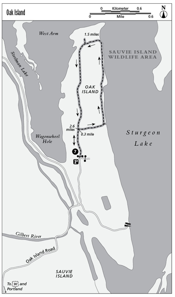
7 Oak Island
This peaceful hike takes you through rolling white-oak woodlands past grassy meadows and fields on Sauvie Island. The trail then travels along the shores of Sturgeon Lake, where you may see blue herons and other abundant birdlife.
Distance: 2.9-mile loop
Hiking time: About 1 hour
Elevation gain: 15 feet
Trail surface: Dirt path
Best season: Mid-January through the end of September
Other trail users: None
Canine compatibility: Leashed dogs permitted
Fees and permits: Parking permit required; purchase at Sam’s Cracker Barrel Store, 15005 Northwest Sauvie Island Road or Reeder Beach RV Park, 26048 Northwest Reeder Road, Portland
Schedule: Open mid-January through the end of September; closed October 1 through mid-January for hunting season
Maps: USGS: Sauvie Island; Maptech CD: Newport/Portland/Mount Hood/The Dalles
Trail contact: Sauvie Island Wildlife Area, 18330 Northwest Sauvie Island Rd., Portland 97231; (503) 621-3488; www.dfw.state.or.us/resources/visitors/sauvie_island/index.asp
Finding the trailhead: From I-405 north in Portland, take the US 30/St. Helens exit. Follow signs to US 30 and St. Helens. Follow US 30 for 10.0 miles north and turn right at the SAUVIE ISLAND WILDLIFE AREA sign. Exit to the right and cross the bridge to the island. After crossing the bridge, continue straight on Sauvie Island Road. Continue 2.2 miles and turn right onto Reeder Road. Travel 1.3 miles and then turn left onto Oak Island Road. Go 3.0 miles to a road fork. Continue straight (the road that goes to the right heads to a boat ramp) for 0.4 mile to a parking area and the trailhead. DeLorme: Oregon Atlas & Gazetteer: Page 66 C2. GPS: N45 42.82' / W122 49.24'
The Hike
At 24,000 acres Sauvie Island is the largest island in the Columbia River. It is located 10.0 miles north of Portland off US 30 at the confluence of the Willamette and Columbia Rivers. At 4.0 miles wide and 15.0 miles long, the island is characterized by fertile farmland, shallow lakes, sloughs, and groves of cottonwood, oak, willow, and ash. The island is home to more than 300 species of animals, including raccoon, beaver, mink, and black-tailed deer. It is also located on the Pacific Flyway, which attracts thousands of migrating birds each year. The northern half of the island contains a 12,000-acre wildlife area, which is managed by the Oregon Fish and Wildlife Service. During fall more than 150,000 ducks congregate in the wetlands on the island. You may see mallards, ruddy ducks, green-winged teals, buffleheads, pintails, and widgeons. This rich variety of bird life attracts not only birders but also hunters. The wildlife area is generally closed October 1 through mid-January for hunting season.
This route explores Oak Island—a small peninsula on the northwest end of Sauvie Island that shoots northward into Sturgeon Lake. This grassy peninsula is covered with thick white-oak woodlands. Small mammals live and feed in the tall wild grasses, and the gnarled branches of the oaks provide shelter for jays, warblers, sparrows, kinglets, chickadees, and nuthatches. Northern harriers sail over the open fields hunting for small mammals, and bald eagles can be seen roosting high in the oak trees from December through March.
You’ll begin this route by walking around a metal gate and onto an old roadbed. Be sure to pick up a trail brochure (available in English and Spanish) that explains the history and natural features of the area. The route continues through a thick white-oak woodland. The doubletrack trail is often overgrown with tall grass (it is recommended that you wear long pants on this hike), and blackberries line the trail in a tumbled mass. The delicious, sweet, purplish berries begin to ripen in mid-August. At 0.6 mile you’ll arrive at Sturgeon Lake, a haven for geese, ducks, blue herons, swans, and sandhill cranes. A short side trail leads to the edge of the lake, where Mount St. Helens looms in the background. The grassy doubletrack road skirts the edge of the lake for another 0.9 mile. The remaining portion of the loop takes you past grassy fields and oak woodland filled with the chatter of squirrels and songbirds.
Miles and Directions
0.0Walk around a metal gate and begin walking on a doubletrack road. Pick up a trail brochure at the trailhead sign located on the right side of the road. After a short distance the road forks.
0.3Turn right and begin the loop portion of the trail.
0.6Arrive at the edge of Sturgeon Lake. A short side trail leads to a rocky beach by the lake’s edge. (Look for sandhill cranes, blue herons, Canada geese, snow geese, and tundra swans.)
1.5The grassy track turns left and away from the lake.
2.6The loop portion of the route ends. Continue straight (right) toward the trailhead.
2.9Arrive back at the trailhead.