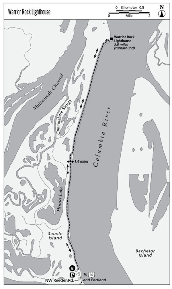
8 Warrior Rock Lighthouse
This route takes you to the tip of Sauvie Island and Warrior Rock Lighthouse. You’ll have excellent views of the Columbia River and opportunities to view abundant wildlife.
Distance: 6.0 miles out and back
Hiking time: About 2 to 3 hours
Elevation gain: 10 feet
Trail surface: Dirt path
Best season: Year-round
Other trail users: Joggers
Canine compatibility: Leashed dogs permitted
Fees and permits: Parking permit required; purchase at Sam’s Cracker Barrel Store, 15005 Northwest Sauvie Island Road or Reeder Beach RV Park, 26048 Northwest Reeder Road, Portland
Schedule: Open all hours
Maps: USGS: St. Helens; Maptech CD: Newport/Portland/Mount Hood/The Dalles
Trail contact: Sauvie Island Wildlife Area, 18330 Northwest Sauvie Island Rd., Portland 97231; (503) 621-3488; www.dfw.state.or.us/resources/visitors/sauvie_island/index.asp
Finding the trailhead: From I-405 north in Portland, take the US 30 West/St. Helens exit and follow the signs for St. Helens. Travel 9.3 miles north on US 30 until you see a sign indicating Sauvie Island Wildlife Area. Exit to the right and cross the bridge to the island. After crossing the bridge, continue straight (north) on Northwest Sauvie Island Road for 2.3 miles. Turn right onto Northwest Reeder Road and go 13.2 miles until it dead-ends at a gravel parking area (the last 2.2 miles of this road are gravel). DeLorme: Oregon Atlas & Gazetteer: Page 66 B2. GPS: N45 48.50' / W122 47.89'
The Hike
Escape from the city to enjoy the solitude of this island hike. The route travels through a thick cottonwood forest to the northern tip of Sauvie Island along the sandy shores of the Columbia River. Large freighters, tugs, and other ships can be seen sailing up the Columbia to the Port of Portland. Wildlife abounds—from great blue herons to bald eagles, not to mention some of the bovine species.
At your halfway point you can view the whitewashed beacon of Warrior Rock Lighthouse, which rests on a sandy beach at the tip of the island. The original lighthouse, built in 1889, was a two-story structure resting on a sandstone foundation and featured a distinctive fog bell. The original lighthouse was replaced in the 1930s with the current 28-foot-tall concrete lighthouse.
Miles and Directions
0.0Start hiking north on the singletrack trail located next to a wood trail sign adjacent to the parking area. (This section of the route can be a bit wild and overgrown.)
0.4Step over a low wire fence. As you continue walking down this smooth country lane, keep your eye out for juicy blackberries that begin to ripen in mid- to late August.
0.5Turn right onto a smooth doubletrack road that continues north through a shady cottonwood forest. Proceed 100 yards and stay to the right at the road junction.
1.4Go through a blue metal gate. (Be sure to close the gate, or you may let some wily cows out of their pasture.)
2.8Turn right on the doubletrack road toward the beach.
3.0Arrive at a long sandy beach. Soak in the views of the expansive Columbia River and whitewashed lighthouse, and then turn around and head back on the same route.
6.0Arrive back at the trailhead.