26 Eagle Creek
This trail through the Columbia River Gorge National Scenic Area traverses a deep scenic canyon carved by bubbling Eagle Creek and shaded by a canopy of oak, bigleaf maple, and cedar. Along the route hikers are rewarded with views of half a dozen cascading waterfalls and a creek perfectly suited for a swim during the hot summer months. Backpackers can hike in and camp at any of the four established campsites along the first 7.5 miles of the trail—but note that these sites fill up fast. For more solitude forge ahead 13.3 miles from the Eagle Creek trailhead to camp at Wahtum Lake.
Distance: 6.4 miles out and back (with longer options)
Hiking time: About 2 to 3 hours
Elevation gain: 385 feet
Trail surface: Dirt path; steep drop-offs on some sections of the trail
Best season: Year-round
Other trail users: None
Canine compatibility: Leashed dogs permitted; use caution with your dog on this trail, as there are steep drop-offs; keep your dog leashed at all times
Fees and permits: Northwest Forest Pass required; passes available by calling (800) 270-7504 or online at www.fs.fed.us/r6/passespermits
Schedule: Open all hours
Maps: USGS: Bonneville Dam, Tanner Butte; Maptech CD: Newport/Portland/Mount Hood/The Dalles
Trail contact: USDA Forest Service, Columbia River Gorge National Scenic Area, 902 Wasco Ave., Ste. 200, Hood River 97031; (541) 308-1700; www.fs.usda.gov/main/crgnsa/home
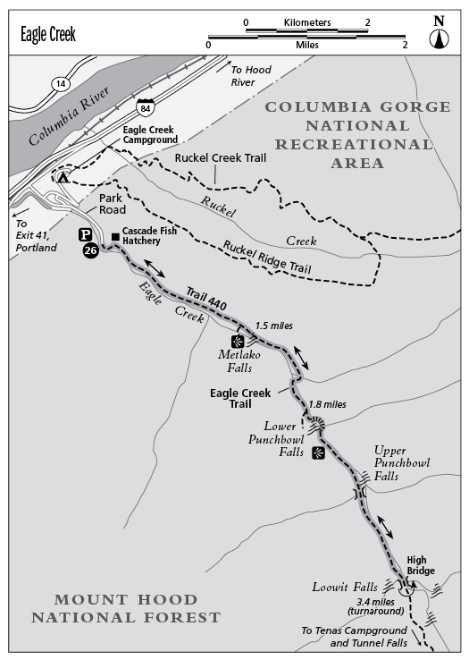
Finding the trailhead: From Portland head east on I-84 for about 41.0 miles. Take exit 41 for Eagle Creek Recreation Area. At the STOP sign, turn right and stay to the right toward the picnic area and trailhead. Continue about 0.5 mile to a paved parking area at the road’s end.
From Hood River head west on I-84 and take exit 40 (Bonneville). Get back on I-84 heading east. Take exit 41 for Eagle Creek Recreation Area. At the STOP sign, turn right and stay to the right toward the picnic area and trailhead. Continue about 0.5 mile to a paved parking area at the road’s end. DeLorme: Oregon Atlas & Gazetteer: Page 68 C1. GPS: N45 38.19' / W121 55.16'
The Hike
Eagle Creek is a classic gorge hike that should not be overlooked by hikers of any level. As you hike this trail, it’s hard not to appreciate the time and effort spent creating this engineering marvel that sweeps along the high cliff walls, offering spectacular views of many of the area’s different waterfalls. Be forewarned, though, if you’re planning on hiking Eagle Creek with children: There are many steep drop-offs along the route, and unsupervised children could be at great risk of falling from one of the trailside cliffs. If you’re determined to take your child with you, be sure to keep a close eye on him or her at all times. This same caution applies to dogs. Keep your dog leashed at all times on this trail.
Because of the trail’s spectacular scenery and fairly easy grade, this very popular hike is often crowded—especially on sunny summer weekends—so consider making the trip on a weekday to avoid the crowds. Otherwise be prepared to share this trail with a slew of fellow outdoor enthusiasts.
The trail starts just above the creek and ascends very slowly over the next 3.4 miles to High Bridge (your turnaround point). Along the route you’ll pass twisted oak trees and shady bigleaf maples. In spring and summer, wildflowers along the trail compete with one another in a show of vibrant colors for all who visit to enjoy.
At 0.8 mile there’s a section of trail that often proves tricky to those unaccustomed to heights. Fortunately, cables are in place to help hikers navigate this precipitous cliffside stretch of trail. The trail is actually in good shape; it’s just the steep drop-off to the right that makes your brain put on the brakes.
After 1.5 miles there’s a very short optional side trail to Metlako Falls, which takes its name from the Native American goddess of salmon (in fact the falls seem to sweep off the basalt cliff like a salmon racing to the sea). At 1.8 miles you’ll arrive at the Lower Punchbowl Falls Trail. Descend steeply here for 0.2 mile to the creekbed and falls, a broad cascade that tumbles into a rocky circular bowl. If it’s a hot summer day, this area will be packed with kids, dogs, and others splashing and wading in the water. Walk a short distance upstream to view the tumbling 30-foot cascade of Punchbowl Falls.
As you continue on the Eagle Creek Trail, the gorge becomes steeper and deeper until you reach the High Bridge—a long, skinny expansion bridge that stretches precariously across the canyon. From the middle of the bridge, you’ll have a giddy downward view into the deep chasm carved by Eagle Creek. The water rushing through the canyon over mossy boulders and ledges is absolutely mesmerizing.
After the bridge it’s time to turn around and head back the way you came. If you still have some energy left, consider pressing on toward Tenas Campground and Skooknichuck Falls, 0.4 mile up the trail. Another 2.0 miles beyond that, you’ll arrive at the roaring cascade of Tunnel Falls.
Miles and Directions
0.0Start hiking on the signed singletrack trail that is lined with oak trees and parallels tumbling Eagle Creek.
0.8The trail becomes precipitous and drops off steeply to the canyon floor. Watch your footing here!
1.5Arrive at a side trail on the right that leads to 100-foot Metlako Falls.
1.8Turn right onto the Lower Punchbowl Falls Trail.
2.0Arrive at a viewpoint of 15-foot Lower Punchbowl Falls. Walk along the creek a short distance to view 30-foot Punchbowl Falls. Once you’re finished viewing the falls, head back to the main trail.
2.2Turn right onto the Eagle Creek Trail.
3.4Arrive at High Bridge—a steel bridge that gives you an amazing view of the narrow creek canyon far below you. This is your turnaround point. Retrace the route back to the trailhead. (Option: Continue 0.4 mile to Tenas Campground and Skooknichuck Falls. Another 2.0 miles beyond Skooknichuck Falls, you’ll arrive at the roaring cascade of Tunnel Falls.)
6.4Arrive back at the trailhead.