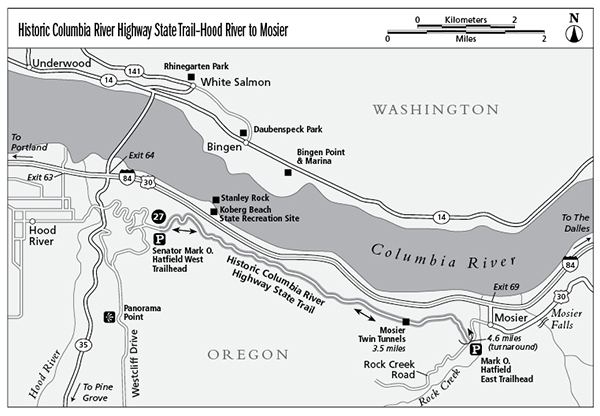
27 Historic Columbia River Highway State Trail–Hood River to Mosier
Relive the historic past by hiking on a restored section of the Columbia River Highway. On this easy paved route you’ll hike along the edge of the scenic Columbia River Gorge for more than 9.0 miles on an out-and-back route between Hood River and Mosier. Along the way you’ll be able to stop at many spectacular viewpoints and have the opportunity to pass through the historic Mosier Twin Tunnels.
Distance: 9.2 miles out and back (with a shuttle option)
Hiking time: About 2 hours with a shuttle; 4 to 5 hours without a shuttle
Elevation gain: 250 feet
Trail surface: Paved path
Best season: Year-round
Other trail users: None
Canine compatibility: Leashed dogs permitted
Fees and permits: Park pass, available at self-pay machines at both trailheads
Schedule: Dawn to dusk
Maps: USGS: White Salmon; Maptech CD: Newport/Portland/Mount Hood/The Dalles
Trail contact: Oregon State Parks and Recreation, 725 Summer St. NE, Suite C, Salem 97301; (800) 551-6949; www.oregonstateparks.org
Finding the trailhead: Mark O. Hatfield west trailhead in Hood River: From the intersection of I-205 and 84 in Portland, go 54.0 miles east on I-84 toward Hood River and The Dalles. Turn off the highway at exit 64 where a sign indicates HOOD RIVER HIGHWAY 35/WHITE SALMON/GOVERNMENT CAMP. At the end of the off-ramp, turn right (south) toward Hood River. Continue 0.3 mile to a STOP sign and a four-way intersection. Turn left (east) onto the Old Columbia River Highway. You’ll also see a sign indicating HISTORIC STATE PARK TRAIL. Travel 1.3 miles on the Old Columbia River Highway until you reach a parking area, visitor center, and the Mark O. Hatfield west trailhead on the left side of the road.
Mark O. Hatfield east trailhead in Mosier: From Hood River go 5.0 miles east on I-84 to Mosier (exit 69). At the end of the off-ramp, turn right. Go 0.2 mile and then take a sharp left onto Rock Creek Road at the HISTORIC STATE PARK TRAIL sign. Continue 0.6 mile on Rock Creek Road to the Mark O. Hatfield east trailhead on the left side of the road. DeLorme: Oregon Atlas & Gazetteer: Page 68 C4, Page 69 C5. GPS: N45 40.85' / W121 24.51'
The Hike
The Historic Columbia River State Park Trail takes you on a tour along a historic section of the Columbia River Gorge Highway. This fun, easy route travels for 4.6 miles between the windsurfing capital of Hood River and the small, cozy town of Mosier. This trail is part of the Historic Columbia River Highway that was originally built between 1913 and 1922.
A main feature of this trail is the Mosier Twin Tunnels, which were originally designed by Conde B. McCullough, a well-known state bridge engineer for the Oregon Highway Department. The tunnels were built in 1921 and were lined with timbers for extra support and finished with handcrafted stonework. The tunnels also featured viewing portals and a mesmerizing cliff walk that was built right into the cliff outside the tunnels. In addition to the Mosier Twin Tunnels, two other tunnels, Oneonta and Mitchell Point, were built along the Historic Columbia River Highway between 1914 and 1921. When the original highway was relocated in the 1950s, the tunnels were filled with rock and abandoned.
In May 2000, Secretary of the Interior Bruce Babbitt announced that 51.0 of the original 55.0 miles of the Historic Columbia River Highway between Troutdale and The Dalles had been designated a National Historic Landmark. An employee of the Oregon Department of Transportation, Robert W. Hadlow, Ph.D., nominated the Historic Columbia River Highway for this special designation, writing: “It is an outstanding example of modern highway development in twentieth-century America for its pioneering advances in road design. The road, and its associated designed landscape, was a technical and civic achievement of its time, successfully mixing ambitious engineering with sensitivity to the magnificent landscape.”
The Mosier Twin Tunnels section of the highway is one of many sites that have been restored and reopened for the public to enjoy. This spectacular 4.6-mile section of trail was opened in July 2000 and cost a hefty $5.6 million! A large percentage of the project was funded with federal dollars, and the remainder was paid for with private donations.
Why did it cost so much? Rock fall at the west tunnel entrance had always been a danger, and it was up to the Oregon Department of Transportation to come up with a viable solution. The solution they chose is a concrete deck structure made up of foam and cement that rests on concrete pillars. The concrete structure is anchored to the cliff with 25-foot anchor bars. This structure is designed to support the impact of a 5,000-pound rock falling from a height of 200 feet. To be sure the structure blended into the natural surroundings, the concrete was tinted a very dark gray to blend in with the surrounding basalt cliff. This amazing project took five years to complete—you will understand why when you ride under the concrete deck and explore the inside of the tunnels.
Before starting your hike be sure to stop at the visitor center and check out the interpretive displays describing the restoration process of this historic route. The friendly folks staffing the desk inside can fill your head with dozens of other things to see and do while you are in the area.
Miles and Directions
0.0Start hiking east on the paved trail adjacent to the visitor center where a trail sign indicates SENATOR MARK O. HATFIELD WEST TRAILHEAD. On the first part of the route, you’ll walk through a wetter ecosystem of fir trees mixed with bigleaf maple and other deciduous tree species. In spring bright purple lupine and bright yellow balsamroot add splashes of color next to the trail.
0.2Pass an interpretive sign on your right that describes the different ecosystems along the route.
2.7Pass a viewpoint on your left of the Columbia River and cliff-lined gorge.
3.5Enter the Mosier Twin Tunnels. From inside the tunnels you’ll have opportunities to stop and soak in more stunning views of the gorge.
3.7Exit the Mosier Twin Tunnels.
3.8Pass a side trail on the left that leads to a viewpoint where you may catch glimpses to the north (on a clear day) of Mount St. Helens and Mount Adams.
4.4At the T-intersection and STOP sign, turn right and head uphill to the Mark O. Hatfield east trailhead.
4.6Arrive at the Mark O. Hatfield east trailhead and your turnaround point (or your ending point if you left a shuttle vehicle at this trailhead). This trailhead also has water, restrooms, and a phone.
9.2Arrive back at the trailhead.