31 Salmon River
Mount Hood National Forest’s Salmon River Trail takes hikers on a journey through a mossy old-growth forest next to the Salmon River, a designated Wild and Scenic River. The trail begins by hugging the edge of the Salmon River. It then climbs a steep ridge, ending with a short loop that offers impressive views of Salmon River Canyon and the surrounding forested ridges of the Salmon-Huckleberry Wilderness.
Distance: 7.2 miles out and back
Hiking time: About 3 to 4 hours
Elevation gain: 950 feet
Trail surface: Dirt path
Best season: June through Oct
Other trail users: None
Canine compatibility: Leashed dogs permitted
Fees and permits: Northwest Forest Pass required; passes available by calling (800) 270-7504 or online at www.fs.usda.gov/main/r6/passes-permits. A self-issue wilderness permit is also required and is available on the trail at the 2-mile mark.
Schedule: Open all hours
Maps: USGS: Rhododendron; Maptech CD: Newport/Portland/Mount Hood/The Dalles
Trail contact: Zigzag Ranger Station, 70220 East US 26, Zigzag 97049; (503) 622-3191; www.fs.usda.gov/mthood/
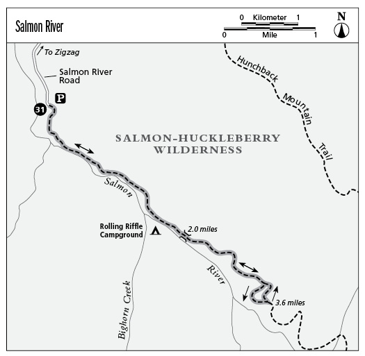
Finding the trailhead: From Portland travel 42.0 miles east on US 26 to Zigzag. Turn right (south) onto Salmon River Road and travel 4.9 miles to the parking area and trailhead on the left side of the road. DeLorme: Oregon Atlas & Gazetteer: Page 62 B1. GPS: N45 16.67' / W121 56.35'
The Hike
Salmon River Trail 742 traipses through the 44,560-acre Salmon-Huckleberry Wilderness, which was established in 1984. Located about an hour from the Portland metropolitan area, the Salmon River has carved a splendid canyon with prominent ridges, buttes, and pinnacles. Chinook and coho salmon spawn in its clear waters, and anglers enjoy casting for steelhead trout in its rushing currents.
Major landmarks in the Salmon-Huckleberry include Huckleberry Mountain to the north, 5,045-foot Devils Peak to the east, and 4,877-foot Salmon Butte to the south. As its name implies, the wilderness is well-known for its purplish, pea-size huckleberries, most abundant near Devils Peak and Huckleberry Mountain. The enticing blue fruit, related to blueberries, is usually ripe by late August and makes for a delicious treat if you happen across some while out along the trail.
The Salmon River trailhead is 4.9 miles south of Zigzag off Salmon River Road (FR 2618). Large red alders, Douglas firs, and western hemlocks shade the trail, and towering old-growth trees give the forest a mystical quality. Beneath these giants are the broad, fan-shaped leaves of vine maple and thick bunches of raspberry bushes. Wildlife includes black bear, mule deer, cougar, badger, and marten.
The trail begins by paralleling the shallow, boulder-strewn Salmon River, which carves its way westward and eventually empties into the Sandy River near Brightwood, 4.0 miles west of Zigzag off US 26. The river, which flows for a total of 31.0 miles, receives its water as snowmelt from Mount Hood’s Palmer Glacier. At 0.4 mile you’ll pass a cliff where thick stems of Oregon stonecrop have a firm grasp on the rocky ledges. The bright yellow flowers of this hardy plant thrive in the sunshine that basks the cliff walls.
At 1.5 miles you’ll come to Rolling Riffle Campground, and after 2.0 miles you’ll cross a footbridge and enter the Salmon-Huckleberry Wilderness. The trail climbs a steep ridge at the base of Devils Peak for the next 1.5 miles. At the top of the ridge is an unsigned trail junction. Take a right and walk a short distance to a spectacular view of the canyon and the river far below.
From here the trail makes a loop along the edge of the ridge. When you’ve finished the loop, return the way you came.
Miles and Directions
0.0Start on the singletrack trail located on the far end of the parking area next to the bridge. The trail takes you close to the river through big old-growth cedars and Douglas fir trees.
2.0Cross a footbridge and arrive at a self-issue wilderness permit station. Fill out a wilderness permit and then continue your journey.
3.4Turn right to begin a short loop.
3.5Exit the trees onto a grassy ridge with spectacular views of the river canyon. (Watch your footing on the trail—it can be loose and slippery.)
3.6Turn left at a T-junction.
3.8The loop section of the trail ends. Veer right and retrace the route back to the trailhead.
7.2Arrive back at the trailhead.