
The Atlantic coast of Europe encompasses a rich diversity of landscapes, climates and cultures. As well as some stunning scenery, a journey down this coast can provide a glut of historic and religious sites, a revelation in beer and wine sampling, certainly a mouth-watering gastronomic progression. But through the diversity along the way there is also a strong connecting thread of music, language, maritime tradition and, some might say, rebelliousness which runs between the peoples of the coast, from the Scots, Irish and Welsh, down through the Cornish, the Breton and south at least to the Basques and Galicians, perhaps beyond. Throughout the cruising season there are many festivals and events which are worth taking into account when you are at the planning stage. You may happen across them serendipitously, but it would be a shame to miss them for want of a day or two. Where possible, annual festivals are mentioned in the port details.
The English Channel is also the main gateway to and from the coasts and many of the capitals of northern Europe. The Baltic Sea, the Scandinavian fjords or the Dutch and German coastal waterways are diverse and popular cruising grounds in the summer season, giving access to several great cities as well as to a range of more natural wonders. From the North Sea coast, sailing up the River Thames into the heart of London is a truly memorable experience. It is also possible to voyage up the Seine from Le Havre all the way into Paris, although this does require you to take your mast down. But from there, with a maximum draught of 1.9m (6ft), you can follow a network of interlinked canals and rivers all the way down through France and into the Mediterranean.

Plan 5 The Atlantic Coast of Europe to 60°N. Ports and passage distances
The Atlantic coast of Europe reaches from 36°N at Gibraltar to the Arctic Circle and beyond. The cruising season runs from May until early October. The window of opportunity for favourable weather is shorter than this as you head towards the north of the region, but extends later into the year as you progress south.
From northern Spain (La Coruña) northwards, the weather pattern is unstable because it depends on the relative movements of areas of high and low pressure. Winds blow predominantly from south-west through to northwest, although winds from other directions are common. Conditions can change very quickly and weather forecasts should be monitored regularly.
The Bay of Biscay has a reputation for particularly unpleasant sea conditions, largely due to the effects of the continental shelf. The rapid change in depth from the North Atlantic to the relatively shallow Bay of Biscay causes the sea state to be rougher than you might otherwise expect. Vessels heading south from home ports in the UK, the Republic of Ireland or northern France encounter the Bay of Biscay within hours of leaving home. The crew are often anxious, seasick, tired from crossing busy shipping lanes, and have not had any time to settle into a rhythm. If you add this to the pot of unstable weather and rough seas, not to mention the unfathomable behaviour of some of the large Biscay fishing fleets, it is unsurprising that Biscay can prove too much of a challenge to inexperienced crew. If you are at all unsure about how well you and your crew will stand up to a Biscay crossing, it is well worth having extra, experienced crew on board for this passage. Alternatively, if you leave early enough in the season and want to take more time over your passage south, it is perfectly feasible to coast hop down the Biscay coast of France and along the north coast of Spain, where there are many unspoilt ports amidst stunning scenery. The coast of Brittany and the ‘rias’ in the north-west corner of Spain are cruising areas in their own right. Whichever route you take, you should plan to be south of Biscay by the end of August, after which the incidence of gales increases.
If you leave the English Channel late in the year you will run the gauntlet of the autumn weather. The incidence of gales in Biscay increases from an average of one day a month in August to nine in November. Timing of departure will rely on detailed long-range forecasts. Consider sailing from England to southwest Ireland to await suitable conditions, or head west of your direct track as you cross the Channel approaches. This puts you well to the west of the continental shelf and increases your sea room in the Bay of Biscay if you are caught in a gale.
Once you have passed Cape Finisterre you should start to experience more favourable conditions, when even the more doubtful crew members will be able to relax and enjoy the passage-making. A large area of low pressure usually forms over the Iberian Peninsula in early summer, dominating weather patterns until late autumn. The western edge of this depression coincides with the eastern margin of the Azores High, giving rise to the Portuguese trades. These are northerly winds that blow down the coast of Spain and Portugal in a band some 100 miles wide. These winds are most reliable from July through to September or October, and may be accelerated by the sea breeze along the coast to strong or even gale force winds for a short time in the afternoon. If the Portuguese Trades have not settled in, this coast can become fog bound for days at a time. However, south of Baiona, ports are spaced at intervals of 50 miles or less down the Portuguese coast and it is possible to hop down the coast in short passages.
Leixões, with its well-protected entrance, is a good port of refuge that can be entered in almost any weather. There is a small marina in the northern corner of what is otherwise a purely functional fishing and commercial port. Inevitably, it can sometimes be rather dirty, but a stopover here is worthwhile because of its proximity to the ancient city of Porto on the Douro river with its famous bridge, port wines and sailing wine barges. The marina monitors Channel 09.
Contact: Marina Porto Atlantico, Molhe Norte de Leixoes
4450-718 Leca da Palmeira. Portugal
Tel: 964 895 Fax: 966 636
E-mail: info@marinaportoatlantico.net
Website: www.marinaportoatlantico.net/english.html
Although the direct course from the English Channel to Madeira passes close to the Spanish coast, it is worth making enough westing to remain a safe distance off shore. The greatest concentrations of commercial traffic are found near the coast which is an area known for its poor visibility. By staying 50–100 miles offshore, you should escape both these problems while still receiving the full benefits of the northerly Portuguese Trades and Portuguese Current.
Depending on your onward plans, any period between late May and early August is the best time for the passage from Falmouth to the Azores. Keep as near the rhumb line as conditions permit. The current sets south-east and prevailing winds are likely to be between south-west and north-west. The Azores High may extend a considerable distance to the north-east of the islands, in which case you may need plenty of fuel.
Onwards to Madeira a pleasant passage can be anticipated, with winds between north-west and north-east backed by a favourable current. There is generally good visibility and relatively little shipping. Though there may be a temptation to linger in the Azores, it would be wise to leave before the middle of September.
The relatively warm water of the North Atlantic Current (previously the Gulf Stream) divides into two as it approaches the British Isles. One part runs up the west coast of Scotland towards Scandinavia and the other is deflected south-east and then south past Spain and Portugal. Smaller branches enter the English Channel and the Irish Sea. This warm water provides a moderating influence on temperatures in the coastal fringes of western Europe, which tend to be much less extreme than those inland.
Both tidal range and strength of stream vary a great deal along the Atlantic coast of Europe. Spring tidal ranges of 12m (39ft) occur in the Bristol Channel, around the Channel Islands and the adjacent French coast. Around Gibraltar the spring tidal range is only 1.1m (3.4ft). The greater tidal ranges naturally give rise to strong tidal streams. These are generally much more significant than any underlying current. On the coast of the British Isles and France, tidal streams regularly reach speeds of 3–4 knots. In the famous ‘Alderney Race’ between the Channel Islands and the Normandy peninsula the flood can exceed 9 knots. Tidal streams can be especially strong off headlands and between islands, with heavy overfalls. If these are marked on the chart you should avoid the area during the periods of strongest flow. If winds blow contrary to the tidal stream, conditions may become dangerous.
The English Channel has one of the world’s highest concentrations of shipping traffic. Maintain a good lookout and proceed with caution if visibility is poor. Yachts are required to cross the charted shipping lanes as quickly as possible and on a course as close to perpendicular (90°) to the lanes as they are able. Stay outside the lanes except when crossing them. Most of the traffic is concentrated on two main routes, one on the northern side between the Scilly Isles and the Dover Strait, and the other on the southern side, between Ushant and the Dover Strait. Each of these corridors has an east-bound and a west-bound lane. There are also ferries sailing between England and France, and many coastal trading vessels, fishing boats and yachts are continually on the move.
Other charted shipping lanes exist off Cape Finisterre and the Portuguese coast and in the Straits of Gibraltar. The whole Atlantic coast of Spain and Portugal tends to be busy with shipping and with fishing vessels.

Plan 6 Prevailing winds and currents off the coast of Europe during August. Based on information from The Atlantic Pilot Atlas

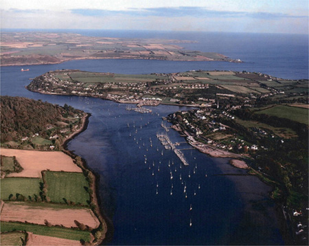
Crosshaven looking east down the Owenboy River. The Royal Cork Yacht Club and marina can be seen on the right. Roche’s Point lighthouse is in the background (top right). Photo: Kevin Dwyer
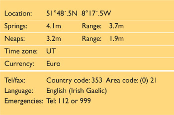
The south-west of Ireland is a green and pleasant land with a stunningly beautiful coastline and many lovely harbours and anchorages. Cork Harbour is a large natural harbour and a busy commercial port which can be entered safely in all conditions.
Crosshaven, on the Owenboy River, is on the west side within the entrance and is the centre for yachting in the estuary. It offers good shelter in all weathers and is the home of the Royal Cork Yacht Club which is the oldest yacht club in the world, founded in 1720. The RCYC has a fine clubhouse overlooking the river, a thriving social and sailing programme and an established reputation for hospitality to visiting sailors. You may well be tempted to try some of the creamy-headed Irish Stout brewed at the local Beamish and Murphys breweries.
It is said that Sir Francis Drake once evaded a superior Spanish force by taking his fleet of ships up the Owenboy River to Drake’s Pool. More common now are fleets of racing yachts and dinghies. Cork Week is a world class regatta held in mid-July every two years and is an exuberant week of competitive sailing and parties. There is plenty to interest visitors in and around Cork, including a visit to Blarney Castle. You may want to try to kiss the Stone of Eloquence, otherwise known as the Blarney Stone, but not if you suffer from vertigo.

Plan 7 Cork (Cobh) Harbour
Landfall on the south-west or southern Irish coast is pretty straightforward. If coming from the Atlantic then Fastnet Rock, Mizzen Head and further north the Skelligs and Blasket Islands are conspicuous and well lit. In bad weather Dingle Bay, Bantry Bay (Bare Haven) or Crookhaven, Schull or Baltimore in Roaring Water Bay offer good shelter. Further east you have Castle Haven and Glandore also available before you reach the Old Head of Kinsale which is a distinctive headland that has a powerful light and is very easily identifiable [Fl (2) 10s 72m 25M]. Kinsale itself has a safe harbour with two marinas and is popular with visiting sailors.
Approaching Cork Harbour from any direction you have no hazards that are of consequence to boats drawing less than 3.5m (12ft) and all the possible hazards for craft deeper than this are well buoyed and lit. Roches Point (on the east side of the harbour entrance) had a sectored red and white light that covers both Daunt and Pollock Rocks. Cork Buoy safe water mark (a red and white pillar) is situated 5M south of Roches Point and 0.8M south-east of Daunt Rock Buoy and is a good initial waypoint. From there the 24m (80ft) Hammerhead Water Tower, south of Crosshaven to the west of the entrance is very conspicuous. If approaching from the UK, the red and white power station chimney north-east of Corkbeg to the east of the entrance is very useful. An approach waypoint of 51°46´.60N, 08°15´.40W puts you on the leading line/lights of 354°.
All dangers are well marked and lit. Rock ledges extend up to 180m (600ft) offshore on either side of the entrance channels. Tidal streams can run strongly in the entrance, reaching two knots at springs, though the strength of the ebb can be somewhat lessened by keeping to the west side of the channel.
The entrance is wide (0.8M) with two shipping channels that are fully buoyed, each with leading marks and lights. Boats drawing less than 5m (16ft) need not worry about draught anywhere other than off Ram’s Head where it is advisable to keep at least 200m (656ft) to the east. The entrance narrows to 0.5M between the Forts. Once past the Forts, alter course to the north-west to pick up the buoyed channel into Crosshaven. This channel is fully buoyed with a minimum depth of at least 3m (10ft) LWS.
Cork Coastguard Radio broadcasts weather forecasts, and monitors VHF Channel 16 and working Channel 26. It should not be confused with Cork Harbour Radio which monitors commercial shipping on working Channels 12 and 14, and Channel 16. The Royal Cork Yacht Club and Crosshaven Boatyard both monitor Channels 16 and M(37) during working hours.
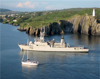
An Irish coastal guard ship enters Baltimore harbour to the west of Cork. Photo: Robin Pharaoh
There are no entry requirements for vessels arriving from within the EU. Yachts owned by EU residents should at all times carry proof of VAT paid status. In the case of a non-EU registered vessel, or if arriving from a non-EU country or with non-EU nationals aboard, hoist the Q flag on closing the land.
Customs and Immigration may be contacted by telephone (Tel: 4324444/6027700, or Freephone 1 800 295295), through any of the marina offices, or via the police station (Tel: 4831222) situated across the road from the Royal Cork Yacht Club.
There are three marinas at Crosshaven on the south side of the river. Other facilities are available elsewhere within Cork Harbour.
The Crosshaven Boatyard has 20 visitors’ berths; 40m (130ft) maximum, 4m (13ft) draught. A 40-ton boat hoist and storage on the hard are available.
Website: www.crosshavenboatyard.com
Contact: Tel: 4831161 Fax: 4831603
E-mail: cby@eircom.net
Salve Marina will accommodate visitors up to 30m (100ft) and 3.5m (12ft) draught. Fuel is available alongside.
Website: www.sailingireland.com/salve1.htm
Contact: Tel: 4831145 Fax: 4831747
E-mail: salvemarine@eircom.net
Plan 8 Crosshaven, Ireland
The Royal Cork Yacht Club will accommodate up to 20m (66ft) and 3m (10ft) draught. The least depth in the Owenboy channel up to the Royal Cork Yacht Club is 3m (8ft), but there are deeper parts beyond, up to Drake’s Pool.
Website: www.royalcork.com
Contact: Tel: 4831023 Fax: 4831586
E-mail: office@royalcork.com
Castlepoint Boatyard has a 15-ton hoist and storage.
Contact: Tel: 4832154.
There is no good anchorage in the lower river, which is crowded and has cables and numerous old chains fouling the bottom, but a mooring may be available through the Royal Cork Yacht Club or Salve Marine Ltd. Drakes Pool, 1.5M up the river, offers anchorage in mud in 2m (7ft) in delightful surroundings, but has no facilities. Use of a tripping line is recommended.
A regular bus service operates to Cork City, from where there are trains and buses to Shannon or Dublin Airports for transatlantic flights. Cork Airport, with regular daily flights to the UK and the Continent is about 16km (10 miles) away. There are daily ferry connections to the UK and services to Brittany from Rosslare three times a week. A weekly ferry service to Brittany (Roscoff) from Cork operates on Saturdays from April to October. The Cork to Swansea (South Wales UK) Car Ferry is due to resume in 2010. A taxi service based in Crosshaven can be contacted on Tel: 4831122.

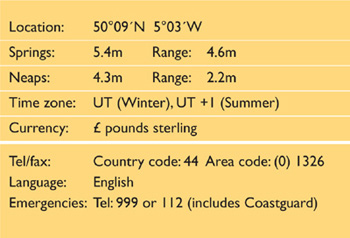
Falmouth is the most westerly of the large English Channel ports and is one of the finest natural harbours in the world, with several miles of sheltered deep water branching off into inlets and creeks which just cry out to be explored. The entrance is well marked and safe under all conditions. Falmouth has excellent and extensive facilities for yachts and is well used to looking after transatlantic sailors, whether they be preparing for departure or making landfall.

Visitors’ Yacht Haven with National Maritime Museum beyond. Photo: National Maritime Museum/Visit Cornwall
The Royal Cornwall Yacht Club always welcomes visiting yachtsmen, and in August each year hosts a Classics regatta and Falmouth Week. The local gaff-rigged Falmouth Working Boats race in Carrick Road on two or three afternoons each week in summer. The racing is a wonderful spectacle but is also taken very seriously, so be careful not to get in the way. You might also see some gig racing – another very competitive Cornish sport. Many of the local boats may be flying the distinctive Cornish flag – the black and white crossed flag of St Piran. The National Maritime Museum overlooks the harbour and has plenty to interest visiting sailors of all ages. Pendennis Castle, built in the 1540s, and facing its sister fort across the water at St Mawes, is a good view point and is well worth a visit. But don’t be surprised by the Noonday Gun which is fired from the castle every day during July and August. The area around Falmouth and the cathedral city of Truro is rich in musical events and is famous for a number of wonderful gardens which are a delight to wander around. Cornwall is developing a reputation for internationally renowned restaurants, but you may also be tempted by the more humble delights of a Cornish pasty and a cream tea.

Plan 9 Falmouth, UK
Heading for Falmouth from points west, the Bishop Rock lighthouse, which marks the south-western extremity of the Scilly Isles, is a likely first landfall. There can be strong tidal streams off the Bishop Rock and overfalls on the Pol Bank, three miles to the south-west. There may also be strong streams off Lizard Point and heavy overfalls extending to the south for three miles or more. Give these points a wide berth, and in strong south-westerlies make no attempt to close the coast until well round the Lizard. Once round the Lizard [Fl 3s 70m 25M] the only danger is the group of rocks known as the Manacles, clearly marked by an east cardinal buoy to seaward. An easterly wind combined with a flood tide can produce a race between Black Head and the Manacles on the direct course to Falmouth. In these conditions, after rounding the Lizard, head towards the Lowland Buoy at about 50°N 5°W which will put you east of the race on your approach. The entrance is passable under all conditions – even with a southerly gale and ebb tide a yacht can enter in safety, if not comfort. The main channel lies between St Anthony Head and the east cardinal buoy which marks the Black Rock Beacon.
The Black Rock Beacon is unlit. In daylight a yacht can safely pass either side of Black Rock with an offing of 100m (330ft), but at night you should use the main channel. There are sometimes shipping movements, often tug assisted, within the harbour and dock area. Some commercial fishing takes place and lobster pot marker buoys may be encountered anywhere in the coastal area, either singly or in attached strings, sometimes well offshore. They are often poorly marked and are a hazard to a yacht under power, particularly at night.
Falmouth Harbour radio: Channel 12 and 16
Falmouth Pilot radio: Channel 09 and 16
Harbour launch Killigrew: Channel 12
Visitors Yacht Haven: Channel 12
Falmouth Premier Marina: Channel 80
Port Pendennis Marina: Channel 80
Falmouth Docks: Channel 11
Entry requirements are waived in the case of an EU registered yacht arriving direct from another EU country (including the Azores). In the case of a non-EU registered vessel, or if arriving from a non-EU country or with non-EU nationals aboard, hoist the Q flag at sea and telephone Customs on 0345 231110 immediately on arrival.
There are three marinas in Falmouth itself. There are further berthing, mooring and anchoring possibilities within the Fal estuary and the nearby Helford River.
The Yacht Haven Falmouth Harbour Commissioners run the Yacht Haven which provides pontoons berths, shower and laundry facilities for up to 100 visitors. The Yacht Haven is suitable for use by vessels up to 16m (52ft) length and 2.5m (8ft) draught (larger vessels may be accepted on application). A dredged approach channel is marked by orange triangular leading marks. The pontoons are very conveniently situated close to shops, pubs, restaurants, cafes and the National Maritime Museum. WiFi is available.
Website: www.falmouthport.co.uk/leisure/html/yachthaven.php
Contacts: The Visitors Yacht Haven (Tel: 310991) or
Falmouth Harbour Commissioners, 44 Arwenack Street,
Falmouth, TR11 3JQ
Tel: 312285 Fax: 211352,
E-mail: admin@falmouthport.co.uk
Falmouth Marina is situated about 0.7M up the Penryn River. The approach and marina have a minimum depth of 2.0m (7ft) and can accept yachts up to 25m (83ft) by arrangement. The river is buoyed, and a narrow dredged channel into the marina is marked with beacons. Secure to the clearly marked reception pontoon until directed to a berth by marina staff. Falmouth Marina accepts some live-aboards and is a pleasant marina in which to winter. There is a supermarket close by.
Website: www.premiermarinas.com/pages/falmouth_marina
Contact: Falmouth Marina, North Parade, Falmouth,
Cornwall, TR11 2TD.
Tel: 316620 Fax: 313939
E-mail: falmouth@premiermarinas.com
Port Pendennis Marina is a marina village development with space for a few visiting yachts. It lies in the southern part of the harbour between the docks and the town and is convenient to the town shops and other facilities. The marina basin, containing about 60 berths, is enclosed within a single tidal barrier with access for about half the tide. The outer section has a 3m (10ft) draught limit, and can accommodate boats up to 50m (165ft) or more, and keeps space for visitors.
Contact: Port Pendennis, Challenger Quay, Falmouth,
Cornwall, TR11 3YL
Tel: 211211 Fax: 311116
E-mail: marina@portpendennis.com
Hoist and hard standing are available at Falmouth Marina and Port Pendennis. Fuel is available at all the marinas listed.
Visitors to the UK should be aware that in popular anchoring areas, particularly on the south coast, there is often a charge made to lie to your own anchor. In some harbours a charge will apply anywhere within the harbour limits, even if you are well off the beaten track. These charges may well exceed the charges for a marina pontoon berth in other countries.
In Falmouth, an anchorage area, suitable for use by small craft in most conditions, is situated near to the Yacht Haven between Custom House Quay and Falmouth Docks. Holding is generally good in firm mud, though there are a few soft patches, and protection is adequate. In northerly winds more shelter may also be found east of the moorings that run between Flushing and Trefusis Point. All vessels that anchor must have a working engine as there may be a requirement to vacate the area, sometimes at short notice, to facilitate commercial shipping movements to and from Falmouth Docks. Skippers of vessels using the anchorage should contact the harbour patrol craft or the Harbour Office or consult the notice board at the top of the Yacht Haven access bridge for information on shipping movements. Skippers should avoid leaving their vessels unattended for prolonged periods at the anchorage.
There are 19 deep water moorings for visiting yachts by the main channel in the northern part of the harbour, including four moorings appropriate for yachts up to 24m (80ft). The moorings are managed by the Falmouth Harbour Commissioners and are marked with green pickup buoys. These moorings cannot be pre-booked and there is a maximum stay of three weeks during the high season (1 June–30 September), beyond which the tariff rate is doubled. If you have paid for a mooring you are entitled to use the shower and laundry facilities at the Yacht Haven. The moorings officer can be contacted at the Falmouth Harbour Office.
Contact: Tel: 312285 during working hours.
E-mail: mo@falmouthport.co.uk
Website: www.falmouthport.co.uk/leisure/index.php
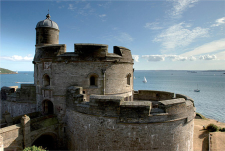
Looking SW from St Mawes Castle over the main approach channel. Black Rock Beacon can be seen to the right of the castle and St Anthony Head light is to the left. Photo: Bob Berry/Visit Cornwall
Take dinghies into the Yacht Haven or the Royal Cornwall Yacht Club (Tel: 312126, Fax: 211614) The RCYC does not have any moorings available for visitors, but has a dinghy landing, showers, a bar and an excellent restaurant (Tel: 311105).
There is bus and rail access to the nearby cathedral city of Truro and onward for nationwide connections. Daily flights to London depart from Newquay airport about 48km (30 miles) away.


Brest is a large city with a proud maritime history. It remains one of France’s primary naval bases, no doubt partly due to its protected and easily defensible position inside the relatively narrow Goulet de Brest some 10 miles from the open sea. The surrounding coast is also the home of many renowned single-handed yachtsmen and women, and the city plays host to Le Figaro single-handed yacht race. Every four years (2012, 2016…) Brest hosts a spectacular maritime festival. This summer festival is a gathering of over 3000 craft from all over the world and celebrates a shared international heritage of sailing vessels, folk music and maritime art. The newly developed Marina du Chateau is conveniently located right in the heart of Brest allowing easy access to transport links and a whole range of facilities for visiting yachts.
The Rade de Brest and the surrounding coast of Brittany is an interesting and varied cruising ground. There are many lovely harbours and anchorages, including Camaret-sur-Mer which is just eight miles by sea from Brest itself.
Brittany is a region of France with strong local traditions, linked with Cornwall through a shared Celtic influence. The Breton and Cornish languages have considerable similarities, and the folk music and dance demonstrate threads of common history. You are sure to notice the distinctive Breton flag which shares with the Cornish its black and white colouring. The Brittany region is famous for its abundant and delicious shellfish, which are served at almost every restaurant as fruits de mer, and for its many more gastronomic delights.
The Brittany coast of France is particularly dangerous to approach in bad weather because of the many off-lying rocks and strong tidal streams. There is also heavy shipping in the Traffic Separation Scheme lanes off Ushant. The many dangers are well marked but it is essential to have an accurate position before closing this coast. The direct approach is to head eastwards through the wide passage between Ile d’Ouessant (Ushant) and Ile de Sein. Heading east or northeast into the Goulet de Brest, off Pointe de St Matthieu at the southern end of the Chenal du Four or from the Chenal de Toulinguet, align the light towers of Pointe du Petit Minou [Fl (2) WR 6s] and Pointe du Portzic [Oc (2) WR 12s] on 068° to leave the well-marked Plateau des Fillettes shoal to starboard. In daylight this shoal can be left to port, but good clearance must be allowed around the Pointe des Espagnols where a wreck on a rock close to the north-east is marked by a white beacon.
If approaching from the north, yachts may use the shorter route through the Chenal du Four between Ile d’Ouessant and the mainland. The approach from the south cuts through the Raz de Sein between the Ile de Sein and the mainland. The northerly and southerly approaches are tidally dependent as the tidal streams run very hard round this corner of France. In particular the Raz de Sein can be very dangerous in strong wind-against-tide situations and should only be used at slack water in those conditions.
French coastal stations do not answer an initial call on VHF Channel 16 unless it is a Mayday call. The commercial port working channel is Channel 12, with Channel 74 used in the military port. The marinas may be contacted on Channel 09 or by telephone between 0800–2200 (reduced hours on public holidays and out of season).
On approaching Pointe du Portzic, the city and port complex will be seen some two miles beyond. For the Marina du Château, use the main harbour entrance which is used by all naval and most commercial ships. The Marina du Château can then be seen on the starboard bow with its entrance facing northwest. It is advisable to go beyond the entrance before turning in so that you have a clear view of vessels manoeuvring inside the entrance.

Plan 10 Brest, France
The Marina du Moulin Blanc is three miles further up the Goulet de Brest, on the eastern edge of reclaimed land near the mouth of the Elorn River, one mile below the two bridges. The marina is approached via a narrow dredged channel with a minimum of 2m (7ft), and the buoyage should be observed.
It is not necessary for a yacht registered in the EU to report to Customs if arriving from another EU country, but failure to do so implies a formal declaration that the vessel complies with all the detailed Customs and health regulations. Non-EU-registered yachts, those arriving from a non-EU country or those with non-EU nationals aboard should report arrival without delay. All yachts must carry some form of registration and insurance, and it is important that these documents are originals and in-date. Officials may visit yachts, sometimes boarding at sea. In addition to checking registration documents and passports, they may check such things as liferaft service dates and expiry dates on flares.
Marina du Chateau is a new 700 berth marina with 125 pontoon berths for visiting yachts of any size. It is situated close to the heart of Brest which has a wide range of shops and restaurants. The railway station is also close by. The marina has an arrangement with one of the supermarkets for free delivery of large orders of stores. There is water and electricity on the pontoons, toilets and showers. Fuel is available 24 hours a day by credit card at a self-service pump where there is also a pump-out facility. In 2009, further marine facilities were planned but not yet complete. If major repairs are needed it may be advisable to proceed to the Moulin Blanc Marina which is under the same management and where there is a 40-tonne boat lift.
Contact: Tel: 98 331 250 E-mail: marina.lechateau@sopab.fr
Website: www.brestclubnautiquemarine.fr
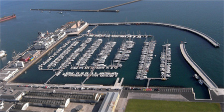
Marina du Château looking SE with the main harbour breakwater beyond. Photo: SOPAB
The Marina du Moulin Blanc is a large marina complex with more than 1,460 berths, of which 120 are reserved in the northern basin for visiting yachts of up to 30m (100ft). The marina has all facilities including a 40 tonne hoist and hard standing. Fuel is available from a fueling berth. The marina is a half-hour bus ride from the centre of Brest but has an arrangement with a supermarket for the free delivery of stores.
Website: www.portmoulinblanc.com/uk/enter.html
Contact: Port de Plaisance du Moulin Blanc, 29200
Brest, France.
Tel: +33 298 022 002 Fax: +33 298 416 791
E-mail: marina.lemoulinblanc@sopab.fr

Moulin Blanc Marina looking SW. Photo: SOPAB
There are many sheltered anchorages within the Rade de Brest, but not adjacent to the port of Brest itself where anchoring is generally either forbidden, or the water too shallow.
Frequent buses into the city from Moulin Blanc. Trains from Brest leave for Morlaix, Rennes and Paris. Brest airport has national and international flights.
There are a number of medical facilities. Ask for advice at the marinas.

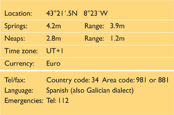
La Coruña is a major city in the green and mountainous region of Galicia in the north-west of Spain. It is a busy fishing and commercial port, and facilities are good for visiting yachts. The British were not always so welcome and the heroine of the city is Maria Pita who helped to defend it against an attack by Sir Francis Drake in 1589. The roots of the city itself go back to Roman times and its most famous and ancient landmark is the 2nd century Tower of Hercules, the world’s oldest working lighthouse. The water front is overlooked by many multi-storey buildings with glassed in balconies which have given rise to the name the ‘crystal city’. Although these newer parts of the city are largely commercial, the older quarters are very picturesque and well worth exploring. Like Ireland, Cornwall and Brittany, Galicia has a strong regional identity rooted in Celtic traditions. August is a month of fiestas in La Coruña when you will be sure to see the gaita (a kind of bagpipe) being played.

Marina Coruña looking south-east along the Dique de Abrigo. Photo: David Ridout
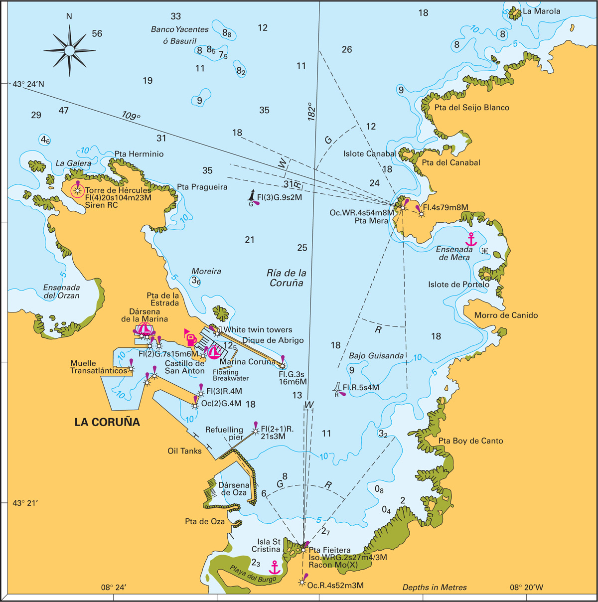
Yachts on passage southwards across the Bay of Biscay may first sight Pta Estaca de Bares [Fl (2) 7.5s 99m 25M] nearly 40 miles to the north-east of La Coruña or Islas Sisargas [Fl (3) 15s 108m 23M] just over 20 miles to the west. Cabo Prior [Fl (1+2) 15s 105m 22M] is about 10 miles north of La Coruña. Overlooking the entrance to La Coruña itself is Torre de Hércules (Tower of Hercules) [Fl (4) 20s 104m 23M] which is conspicuous, day or night. The entrance is straightforward by day or night. Dique de Abrigo is visible from some distance and lit at its eastern end. The tall, white twin towers near its root house the port authorities.
Plan 11 La Coruña, Spain
There are various banks and shoals in the approaches which, although not of depths to trouble yachts, can cause the seas to break severely in bad weather. In these conditions the best approach is from the west on a bearing of no more than 145° on the Torre de Hércules, until the prominent Punta Mera leading line on 109°, which leads inside the off lying banks, can be picked up. The Punta Fieitera leading line on 182° will then lead in close to the south-east end of Dique de Abrigo. Two floating breakwaters some 200m (660ft) long lie across the water between the Dique de Abrigo and Castillo de San Anton. These are positioned such that they protect the southeast side of the Marina Coruña. They are low in the water and may be difficult to see, particularly at night.
La Coruña port control operates on VHF Channel 12. The marinas monitor Channel 09.
Darsena Marina showing the entrance. Photo: David Ridout
In theory it is not necessary for a yacht registered in the EU to report to Customs if arriving from another EU country unless there are non-EU nationals aboard. However, it can do no harm to check in, and non-EU-registered yachts should report arrival without delay. Enquire at the marina or yacht club as to current procedure.
Marina Coruña (43° 22´N 008° 23´W) is a new marina at the root of the Dique de Abrigo breakwater, just on the south side of the conspicuous harbour control twin towers. Entrance is very easily accessible by day or night. Two wave breakers protect the marina from the south-east. The marina provides a wide range of facilities including WiFi access. There is a restaurant in the port control towers which gives fantastic panoramic views.
Website: www.marinacoruna.es/e_index.htm
Contact: Marina Coruña, Paseo Alcalde Francisco Vazquez, s/n. 15001. La Coruña.
Tel: 881 920 482 Fax: 981 228 181
E-mail: marinacoruna@marinacoruna.es
Marina Seca (43° 20´.94N 008° 23´.05W) is a sister facility to Marina Coruña, located next door. Marina Seca has extensive boatyard facilities including a 50-tonne travel hoist and dry storage under cover.
Website: www.marinaseca.com/e_index.htm.
Contact: Darsena Deportiva Faro de Oza s/n.15006, La Coruña.
Tel: 881 916 351 Fax: 881 913 649,
E-mail: marinaseca@marinaseca.com
Darsena Deportiva de La Coruña is situated in the Darsena de la Marina (43°22´.2N 008°23´.6W) which is the old fishing harbour in the heart of the city. There are 40 visitors’ berths and a range of facilities.
Website: www.darsenacoruna.com/
Contact: Tel: 981 914142 Fax: 981 914144
E-mail: info@darsenacoruna.com
Fuel is available alongside at Marina Coruña. Haul-out may be possible at any of the listed marinas. Harbourmaster contact: Tel: 226001, Fax: 205862
The area for anchoring has now been considerably reduced by the expansion of Marina Coruña. It is possible to anchor further out, in about 12m (40ft) over mud. However, there is little shelter from winds from the south-east sector, holding is patchy, and a trip line is advisable. Various other anchorages exist in the Ría de la Coruña, but none are convenient to the city. There are few moorings.
Local buses, trains to Madrid and elsewhere. Airport with national flights and flights to UK. The main regional airport at Santiago de Compostela, about 60km (38 miles) away, handles many international flights. Ferries to the UK from Santander.


Baiona was Columbus’s first Iberian landfall where he proclaimed his discovery of the new world on his return from the Caribbean in 1493 aboard the Pinta. The harbour remains a popular landfall for cruising sailors and can be entered in all weathers by day and night. Shelter is good. Baiona is picturesquely overlooked by a walled fortress which is now a Parador hotel. The views from the walls look down over the harbour and town and northwards to the Islas Cies. Many mediaeval buildings remain in the town, including the well preserved cathedral. As in La Coruña, August is a fiesta month in Baiona, particularly around the weekend nearest to 15/16 August. Try some of the local speciality seafood dishes or buy the ingredients at the busy fish market. The Monte Real Yacht Club is an old established yacht club which hosts local, national and international competitive sailing events. The busy, ship building, port city of Vigo is only a few miles up the Ria Vigo and is likely to provide any facilities that cannot be found in Baiona. The Islas Cies lie within the Galician Atlantic Islands National Park and are a lovely place to anchor and explore for a few days while you are in Baiona.
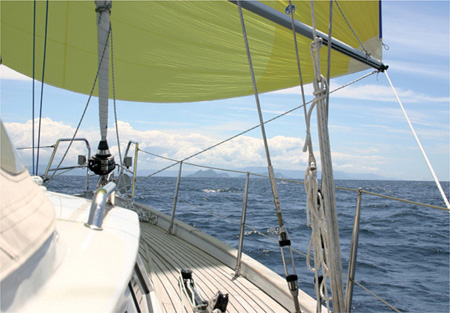
Approaching Baiona from the north. The Islas Cies are distinguishable from the mainland beyond them. Photo: Graham Adam
Plan 12 Baiona (Bayona), Spain
Approach may either be made from the north, passing inside the Islas Cies and with Cabo de Home and Punta Robaleira [Fl (2) WR 7.5s 25m 11/9M] to port, or from the west, to the south of the Islas Cies and leaving the Islote Boerio (or Agoeiro) [Fl (2) R 8s 21m 6M] to port and Cabo Silleiro [Fl (2+1) 15s 83m 24M] to starboard.
The main entrance to the harbour leaves Las Serralleiras [Fl G 4s 9m 6M] well to port. Two cardinal buoys mark the western extremity of Las Serralleiras and Islas las Estelas. The leading lights then bear 084°, with the front one, Cabezo de San Juan, being on a shoal almost in the centre of the bay. In daylight, both Pta del Buey and the breakwater head can be left relatively close to starboard.
If coming from south of west, note that off lying rocks extend some distance northwards of the Cabo Silleiro headland which itself lies nearly one mile north of the Cabo Silleiro light. The Canal de Porta inside the Estelas islands shoals to 0.9m (3ft).
The Harbourmaster and marinas monitor VHF Channel 06.
In theory it is not necessary for a yacht registered in the EU to report to Customs if arriving from another EU country and crewed only by EU nationals. However, it can do no harm to check in, and non-EU-registered yachts should report arrival without delay. Enquire at the marina or yacht club as to current procedure.
Puerto Deportivo de Baiona is a new marina which welcomes visiting yachts and offers pontoon berthing and all facilities including a 45-tonne hoist and fuel dock. PDB is situated south of the breakwater and to the south-east of the fishermen’s mole.
Looking south over Baiona. Photo: www.patrickroach.com
Website: www.puertobaiona.com
Contact: Puerto Deportivo de Baiona, Avenida Monterreal s/n 36300, Baiona.
Tel: 38 51 07 Fax: 35 64 89
E-mail: puertobaiona@puertobaiona.com
Monte Real Club de Yates de Baiona occupies an imposing building overlooking the harbour. The yacht club administers its own marina pontoons, moorings and facilities and may have visitors’ berths available. There is a restaurant in the yacht club which welcomes visiting yachtsmen. There are draught restrictions in some parts of the yacht club marina. Repair facilities include a 17-tonne travel lift which may be tidally dependant. Fuel is available alongside.
Website: www.mrcyb.es/
Contact: Avda. Arquitecto Jesús Valverde, s/n, Reciento del
Parador Nacional, 36300 Baiona
Tel: 385 000 Fax: 355 061 E-mail: mrcyb@mrcyb.com
There is an area of yacht anchorage to the south and southwest of the mole, outside the mooring buoys. It has excellent holding but is subject to swell in some conditions. The fairway leading to the fishermen’s mole south of the yacht club pontoons should be left clear. The moorings are administered by the yacht club, so you should consult the MRCYB berthing master rather than the marina. The yacht club does not like dinghies from anchored yachts being left tied to its pontoons, but there is generally space to leave a dinghy on the pontoons at the fishermen’s mole.
It is a short sail to the Islas Cies where there are some delightful anchorages. Islas Cies is a protected area and you need prior permission to land.
There are good train and bus connections from Vigo and national and international flights from Vigo Santiago de Compostela (about an hour away), or Porto.

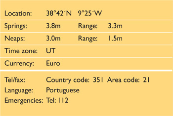
Cascais lies on the northern shore at the entrance of the River Tagus which runs up to Lisbon and beyond. There are very good train links between Cascais and Lisbon which are about 10 miles apart. Lisbon is the vibrant and modern capital of Portugal with a history of seafaring and exploration. Vasco de Gama set off from this region on his voyages of exploration. The maritime museum, just inland from the Tôrre de Belém, is particularly fascinating. Cascais itself has good shops, and restaurants where you can try the local bacalhau dishes made from dried and salted codfish. Throughout the region you will see buildings clad with beautifully crafted white and blue tiles (azulejos). Some tile compositions cover vast wall areas and tell elaborate stories. An interesting day trip away from the coast is to the town of Sintra which is a World Heritage Site because of its 19th century Romantic architecture. The marina is a busy yachting centre and hosts a number of international sailing events.
If making landfall from north or west, the high cliffs of Cabo da Roca [Fl (4) 18s 164m 26M] are likely to be the first identifiable feature. Five miles further south is the lower headland of Cabo Raso [Fl (3) 15s 22m 20M]. The Bay of Cascais is approximately nine miles south-east of Cabo da Roca. The marina is just east of Santa Marta point. There are three cardinal buoys marking the breakwater. Leave these to port. Keep well clear of the end of the breakwater which extends further under water, leaving to port a small unlit red buoy. The reception quay is on the starboard side as you enter the marina beside the green and white striped entrance marker.
Cascais Marina is on Channel 09.

Cascais Marina in the approaches to Lisbon, looking NW. The anchorage is to the right of the marina. Photo Anne Hammick.
Plan 13 Cascais, Portugal
All non-EU yachts should report their arrival to the relevant authorities. Report to the marina office with the usual papers and passports on arrival and fill in a standard form.
Marina de Cascais has 650 berths, maximum draught 6m (20ft), with over 100 retained for transient visitors. There is berthing for larger yachts on a protected pontoon outside the marina. The marina has a full range of facilities, including a 70-tonne travel lift, fuel, water, electricity and a small supermarket on site.
Website: www.marina-cascais.com/eng/index_eng.html
Contact: Marina de Cascais, Casa de S. Bernardo, 2750-800
Cascais.
Tel: 4 824 800 Fax: 4 824 899
E-mail: info@marina-cascais.com
Other berthing facilities are available at Oeiras, halfway between Cascais and Lisbon, and in Lisbon itself.
The anchorage in Cascais Bay is good in sand and mud, but quite a large area is occupied by small-boat moorings. It is generally protected from the north but, in the summer, strong northerly winds can come down off the mountains. The anchorage is open to the south, although southerly winds are rare during the summer months.
There are frequent and swift train communications from Cascais to Lisbon every 30 minutes via Estoril and Belém. An efficient metro, frequent buses and trams run throughout the city, including connections to the international airport in the north-east part of the city, which is less than one hour away from Cascais.