Historical Footnotes: Goldeye Lake
Goldeye, a popular, silver-coloured sport fish, was stocked in this lake in the 1940s, thereby lending its name to these waters. Today, goldeye are not found in this lake; indeed, they are only found in the North Saskatchewan River downstream from Rocky Mountain House. Goldeye Lake is stocked, however, with rainbow trout, making it a popular fishing spot. Fishermen using boats are restricted to electric motors. Another name for Goldeye Lake, still in some local use, is Pine Tree Lake.
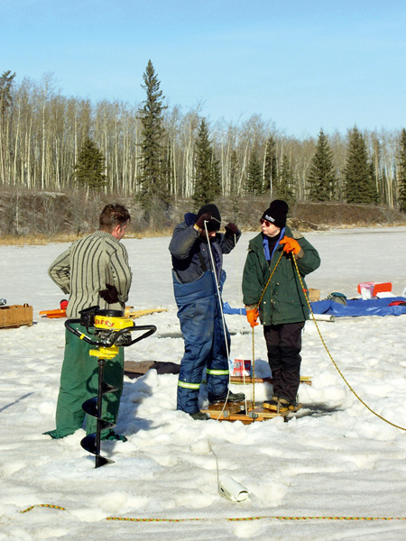
Coring a lake in northern Alberta to recover sediment for pollen analysis. Here a three-metre-long collecting tube has been lowered to the lake floor through a hole cut in the ice surface. The tube is being driven into the sediments to collect a continuous sample. Then the tube will be pulled to the surface, capped and returned to the laboratory so the contained sediments can be analyzed. Courtesy of the Royal Alberta Museum
During the 1980s and ’90s, researchers from the University of Alberta conducted palynological research at a number of sites along the eastern slopes of the Rocky Mountains, including Gold-eye Lake. They drew core samples from the bottom of the lake to extract the pollen trapped in the mud. By studying the ancient pollen, the researchers learned what plants grew in the area, and, therefore, what the climate and landscape were like thousands of years ago.
At the height of the last ice age, around 18,000 years ago, the eastern slopes would have mostly been covered by ice. As the climate began to warm, ice melted and bare ground was exposed. The first vegetation at the end of the last ice age around Gold-eye Lake was tundra-like, with some shrubs but no trees. The most common pollens were from willow, sage, grass and sedge plants. As the climate began to moderate, more trees appeared in the area, including aspen, spruce, birch and pine, and the land became more forested. First, birch and poplar formed an open woodland; then conifers became more prevalent. By about 10,000 years ago, the forest vegetation around Goldeye Lake would have looked quite similar to that seen here today.