
25. Hoodoo Creek
Map F (p. 116)
| Duration | half day |
| Distance | 5.2 km |
| Level of Difficulty | rock scramble up stream bed |
| Maximum Elevation | 1740 m |
| Elevation Gain | 400 m |
| Maps | 83 C/1 Whiterabbit Creek; 83 C/8 Nordegg |
Access: Park your vehicle on Highway 11 at Hoodoo Creek, 3 km south of Windy Point. The creek is located 38 km south of Nordegg, or 45 km north of the Banff National Park boundary.
0.0 kmtrailhead
1.0 kmchute
1.3 kmhoodoos
2.3 kmcave
2.6 kmfork in Hoodoo Creek
5.2 kmtrailhead
The broad gravel wash that is Hoodoo Creek leads up into an ever-narrowing ravine. Although a 1966 Calgary Power map calls this stream Bear Creek, it is an impressive pair of hoodoos that give this creek its name. Hoodoos are not the only geological phenomenon along this hike. For the spelunker in all of us, there is a shallow cave above the hoodoos that invites a visit.
There is no discernible trail up the wide, stony and apparently dry creek bed, so pick your way upstream as best you can. On a cloudless summer day the sun’s rays bouncing off the rocks can make this a very hot hike and if you haven’t filled your water bottle you may be concerned. But don’t worry; within a kilometre the stream re-emerges to flow through a gorge, giving you plenty of opportunity to replenish your canteen.
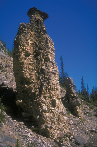
The stream bed begins to narrow where it takes a lazy bend to the left. It continues to narrow as you climb. Finally, you come to the end of the gravel wash. It is here the stream flows through a small gorge, and it is up this gorge that you must find your way, first on one side of the stream and then on the other. It is not long before you reach two 10-m-high hoodoos, complete with “caps,” poised above the gorge on the right-hand side of the creek. Upstream from the hoodoos the rushing waters of Hoodoo Creek sluice over the smooth rocks. An easily discernible trail on the left-hand side of the creek goes past several difficult spots in the stream bed, where huge boulders block your path.
It’s a scramble along the embankment until you come to a cave above and on your right. Scramble up the short but steep trail that leads to the mouth of the cave. Caves are always interesting and this two-room cave makes a perfect spot to rest and enjoy the view. Stoney oral tradition speaks of a cave near Windy Point that was home to some Métis trappers around 1900. This may be the place. In the cave there is a second room and a tunnel. The tunnel extends back about 7 m, where it is blocked by debris. It does go beyond this point, possibly breaking the surface, for pine needles can be found on its floor.
Hoodoo Creek.
Returning to the trail along Hoodoo Creek, turn right and continue to climb steeply to a fork in the creek. Along the left-hand fork there is a picturesque cascade. If you look up the right-hand fork, you can see a window in the ridge.
Return the way you came.
Geofacts: Hoodoos
Rising some 10 m above the creek bed, the hoodoos that are seen on this hike are evidence that glaciers once spread across the Front Ranges.
Glaciers advanced and retreated a number of times. Each time the glaciers spread their tentacles down the mountain valleys, they dislodged and carried rock, depositing it along the way. This deposit was a mixture of clay and sand fragments and occasionally large rocks. This poorly sorted mixture is called till.
The hoodoos on Hoodoo Creek.
In some places dissolved limestone in the till provided calcium carbonate, which cemented the deposits. As water eroded the deposits, pillars of hardened till have remained. These pillars are called hoodoos. Large blocks called cap rocks can often be found perched on top of the hoodoos, further helping to protect the till beneath.