
49. Flag Hill
Map M (p. 242)
| Duration | one hour |
| Distance | 1.4 km |
| Level of Difficulty | light bushwhack followed by easy ascent |
| Maximum Elevation | 1450 m |
| Elevation Gain | 80 m |
| Maps | 83 C/1 Whiterabbit Creek |
Access: Park your vehicle on an unmarked culvert levee on the west side of Highway 11, located 2 km north of Two O’Clock Creek, or 59 km south of Nordegg, or 24 km north of the Banff National Park boundary.
0.0 kmtrailhead
0.2 kmbase of slope
0.3 kmtrail
0.7 kmtop of ridge
1.4 kmtrailhead
This quick hike along the spine of a low ridge takes you to an improvised flagpole where the Canadian Maple Leaf snaps in the prevailing westerlies.
The flag on Flag Hill.
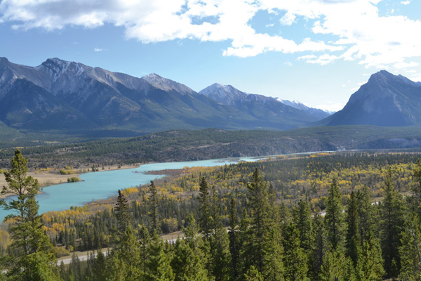
The view from the top of the ridge in the autumn.
From your vehicle, walk along the short levee and enter the trees. The lower end of the trail is often difficult to find, so if in doubt, simply bushwhack straight ahead through the open forest as far as the base of the slope of Flag Hill. To find the well-defined trail up the spine of the ridge, bear left at the base of the slope and follow it until you intersect with the trail. You will find the trail more quickly this way than if you scrambled straight up the slope.
Once on the trail, it is a straightforward lope along the spine, past several rocky outcrops, to the top of the hill. Some enterprising soul(s), perhaps on Canada Day, secured a makeshift flagpole to a lone pine tree from which they hung the Canadian flag. It’s been an easy, quick hike. Why not linger awhile to enjoy the lovely view up and down the valley? The views are always beautiful and, in autumn, the meadows of the Kootenay Plains turn golden, as do the poplars, contrasting with the dark greens of the lodgepole pine and Engelmann spruce.
Return the way you came.