50. Two O’Clock Ridge
Map M (p. 242)
| Duration | full day |
| Distance | 18 km |
| Level of Difficulty | long, steady climb to alpine |
| Maximum Elevation | 2515 m |
| Elevation Gain | 1150 m |
| Maps | 83 C/1 Whiterabbit Creek |
Access: Park your vehicle close to campsite no. 12 at the Two O’Clock Creek Recreation Area campground, located 61 km south of Nordegg, or 22 km north of the Banff National Park boundary, on Highway 11.
0.0 kmtrailhead
0.1 kmjunction
0.3 kmjunction
0.4 kmjunction
0.7 kmjunction
0.9 kmjunction
1.0 kmTwo O’Clock Creek
1.2 kmjunction
1.4 kmbraid
1.5 kmjunction
2.0 kmjunction
2.5 kmjunction
2.9 kmjunction
3.4 kmcliffs
9.0 kmrock cairn
18.0 kmtrailhead
This is a great day hike for those who like to give their legs and their lungs a good stretch. The reward for a long and relentlessly steep climb is a gloriously panoramic view on top.
Your well-defined gravel trail begins across the road from the no. 12 campsite. The trail leads up a set of stone steps to a gate and cattle guard that takes you into the Kootenay Plains Cavalcade Group Camp. At the gate, the trail forks. Bear to the right and walk along the road toward the toilets. Behind the toilets is a fence and another cattle guard. Here you intersect with a broad footpath. Turn left and begin a slow, easy climb up through open bush of poplar, spruce and some pine trees. Taking the right-hand fork takes you back to the campground. In late spring and early summer, the grasslands abound in Indian paintbrushes, purple and white asters, wild roses, the lovely blue harebell and yarrow.
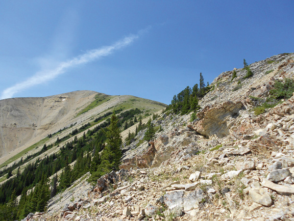
Two O’Clock Ridge, your destination. Courtesy of Kurt Otto
Within 100 m, a secondary trail joins the main footpath. Turn right onto this narrower path; the trail to the left leads into the Sundance Lodge Loop hike. Continue your slow climb upward through open poplar stands. At a fork in the trail, keep to the left; going right returns you to the campground. Continue to climb. At yet another fork, keep to the right along the main path. To the left is an informal campsite. Shortly beyond this point, you come to Two O’Clock Creek. Cross the log bridge and find the trail as it leads upstream along a low ridge. You have gained a little elevation by now and Mount William Booth and Ex Coelis Mountain are visible behind you. At a fork in the trail, you have a choice. You can keep on the main footpath by taking the right-hand fork, or if you wish to keep Two O’Clock Creek in sight, take the left-hand, lower fork. The latter connects with the main footpath at the 1.5-km mark. There are several braids in the main trail as it climbs along the ridge. Keep to the left until a junction in the trail: it is here that Two O’Clock Creek takes a 90-degree turn to the right and this is where the lower trail along the creek joins the main footpath. At the junction, turn right and continue to climb steeply. A faint footpath joins from the right at the 2-km mark; ignore it and bear to the left to remain on the main trail. As you climb, an open ridge above you to the right comes into view. That is your destination.

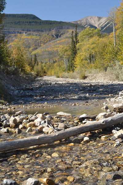
It’s a steep climb, but the scenery is worth it. Courtesy of Kurt Otto
The trail becomes steeper after a major intersection with a trail from the left. If you are low on water, nip down the left fork 100 m to the creek, for this will be the last chance to fill your water bottle. Otherwise, keep to the right and climb, climb, climb. Spruce trees and junipers make this a pretty hike, giving the slope a park-like setting above the creek valley. Two O’Clock Ridge is straight ahead. The trail climbs sharply to the top of the ridge, offering great views ahead. It then descends into a boggy area, where the beautiful round-leaved orchid and purple violet can be found. Climbing out of the bog, the trail swings onto another ridge to continue its relentless march upward. When you arrive at the edge of the ridge, there is a fork in the trail. Bear to the right and continue the ascent; the trail to the left is a game trail that descends to the creek. When returning, this junction is easy to miss. Watch for the surveyor’s tape in the trees that marks the way.
Stop occasionally to catch your breath and enjoy the glorious view. The top of Tuff Puff is on your left. Below are cliffs of red shale that herald the Two O’Clock Creek gorge. As the trail approaches a set of low cliffs, it peters out. Climb on top of the grassy slope to avoid the cliffs. From here, the trail becomes faint as it winds through the trees and open areas. From time to time there is surveyor’s tape in the trees to mark the way. Stay within 30 m of the edge of the gorge. As you reach the base of the first knob below Two O’Clock Ridge, the trail veers to the right, away from the gorge. After the trail swings back to the left, the hike becomes a bit of a scramble up through the scree. At the top of the knob, you can see the destination, so continue up the open ridge. In late spring, the lichen-covered scree slope is sprinkled with wild strawberries, purple sweet vetch and pretty miniature snapdragons called butter-and-eggs.
What’s in a Name? Two O’Clock Creek
Two O’Clock Creek.
This is a descriptive name for a phenomenon common in mountain streams. It also is a consideration for cautious travellers.
On warm sunny days in late spring and early summer, meltwater from ice and snow upstream increases in volume as the day progresses. By mid-afternoon, creek crossings can be downright dangerous. Early travellers and wise hikers plan to cross creeks before or after two o’clock when the creek has crested.
Florafacts: Prickly Wild Rose
Scientific Name: Rosa acicularis
Stoney Names: Hupe Warphen (the leaves); Ozirta (rose hips); Hupe Pe (the bloom)

Alberta’s provincial flower, the prickly wild rose.
Alberta’s floral emblem, the prickly wild rose, can be found along roadsides, as in the case of the Two O’Clock Creek Recreation Area campground, along south-facing slopes and in open woods. The pink blooms of late spring give way in late summer to red fruit called rose hips.
Today, we use the hips to make jam, jelly and tea. The Stoneys made wide use of the leaves, hips and roots of this plant. When boiled, the leaves produced an infusion used to cure stomach aches. Also, a paste made by chewing the leaves was applied to bee stings. High in vitamins A and C, rose hips were used in soups and mixed with grease to be eaten with dried meat.
The hips also have medicinal qualities. When made into a poultice, the hips were found helpful in relieving the pain of boils. Also, the Stoneys drank an infusion of the hips as a treatment for tuberculosis. A rather bitter drink made from the roots was made to cure diarrhea. If peeled and scraped, the inner bark, when boiled, was found to be an excellent treatment for sore eyes.
It is difficult to distinguish the prickly rose from another common Alberta species, the wood rose. Usually the prickly rose has a smaller and thicker covering of prickles than those of the wood rose. Hybridization between these two species also makes identification difficult. But then a rose by any other name is still a rose.
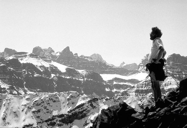
In early spring you will probably have to hike through some snow to reach the top of the ridge and its glorious view. Courtesy of Chris Hanstock
Two rock cairns confirm your arrival at the peak of Two O’Clock Ridge. Below, to your left, is a large lush meadow with a small stream running through it. The top of Tuff Puff is beyond the meadow, and far below is Highway 11, the confluence of the Siffleur and North Saskatchewan rivers and the Kootenay Plains. If you have time, continue along the ridge. From atop the peak ahead, you can see Landslide Lake.
Remember to add a rock or two to the cairns before returning the way you came.