59. Hummingbird Pass
Map O (p. 295)
| Duration | full day |
| Distance | 14.4 km |
| Level of Difficulty | steady climb to alpine area |
| Maximum Elevation | 2300 m |
| Elevation Gain | 365 m |
| Maps | 83 C/1 Whiterabbit Creek |
Access: Your trailhead is the continuation of the horse trail at the south end of Farley Lake.
0.0 kmtrailhead
1.0 kmHummingbird Pass horse trail
2.7 kmNorth Ram River
4.2 kmstream
4.3 kmstream
4.5 kmstream
5.6 kmstream
7.2 kmHummingbird Pass
14.4 kmtrailhead
The scenic approach and stark alpine terrain at Hummingbird Pass makes this the most popular day hike for hikers spending an extra day at Farley Lake.
From the campsite at the south end of Farley Lake, retrace your steps back to the horse trail. Turn right onto the trail and follow it as it skirts the left side of the lake. If the lake is not full and you find that the talus is too rough, drop down to the mud flats. Walk to the end of the lake (or the mud flats), ignoring the cutline to the left. The horse trail disappears at this point. Swing to the right and find a gravel wash. Turn up the wash and continue walking until you see the horse trail reappear between the willows on your left and a talus slope on your right. Immediately begin a steep climb, first beside the talus and then in the forest.
The trail levels briefly before snaking up a second pitch. This part of the trail is almost always wet due to the springs that ooze from the rocky slope. The mud is rather slippery, so some caution is advised for those who prefer clean knees. After a kilometre or so, hints of views can be seen to the left. At the same time, you can hear the North Ram River below. The trail flattens as it crosses the top of the ridge then drops down to the North Ram. The river is a mere stream at this point and your crossing is an easy hop and a skip. High limestone ridges and peaks of the Ram Range on the left now keep you company all the way to the pass.
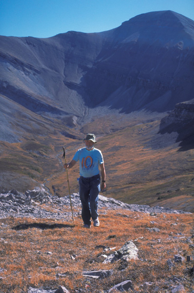
The last pull up Hummingbird Pass.
Florafacts: Mountain Slopes and Passes
On the climb from Farley Lake to Hummingbird Pass you walk through two ecoregions – the subalpine and the alpine. Both ecoregions share similar factors that determine the type of flora found here. For example, both ecoregions are found at high elevations that are dominated by limestone and shale peaks and by eroded, more rounded slopes. The type of terrain determines, in part, the amount of soil that can support plant life. Little soil can cling to steep slopes, and where the bedrock is exposed there is no soil at all. On the other hand, at the base of gentler slopes accumulated material eroded from above forms a thin layer of soil.
Another commonality the two ecoregions share is the climate. Cool summers and cold, wet winters are as much factors in the determination of plant species as is the elevation and type of terrain. Snow does not melt at these elevations until early summer, and can return to stay for the winter months as early as September. In addition, snow is possible in any month. The growing season, then, is remarkably short. Yet the overall climate is not as severe as it might seem. The ameliorating factor is the chinooks that funnel through the North Saskatchewan River valley. While the chinooks in the dead of winter do not lay bare the mountaintops as they do the Kootenay Plains below, their warm Pacific air does lessen the severity of the climate.
The type of vegetation these
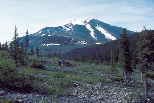
The alpine meadow below Hummingbird Pass. Courtesy of Alfred Falk ecoregions support changes with location. Elevation plays an important role in determining plant species. The pine and spruce forests of the subalpine become thin and stunted the higher you climb. Near the timberline, the proud Engelmann spruce is dwarfed to a gnarled, low, shrub-looking tree called krummholz. Unable to withstand the winds that whip near the mountaintops, krummholz spruce and fir grow slowly outward instead of up. In the alpine, with less soil and greater winds, they disappear completely. As you climb into the alpine region, the broad valleys and slopes are home to an array of wildflowers such as mountain cinquefoil, moss campion and alpine varieties of forget-me-not, harebell and poppy.
Another factor determining the type of plants found here is the direction of the mountain slopes. North-facing slopes receive much less direct sunlight and are more protected from the prevailing winds than south-facing slopes. In the subalpine, these slopes are thickly forested with lodgepole pine and, as you climb to the alpine, Engelmann spruce and fir. Heavily shaded forest floors support mosses and moisture-loving woodland flowers such as orchids. In contrast, south-facing slopes are often open and exposed to wind and sun. Lodgepole pine is the dominant tree found here. There are more varieties of wildflowers on south-facing slopes, and you can spend considerable amounts of time trying to identify the Indian paintbrushes, avens and dryads.
Climb through beautiful alpine meadows, interspersed with willows and small spruce. On your right, across the valley, are impressive peaks, precipices and scree slopes. As you cross a gravel wash, bear slightly to the left to regain the trail. Cross a small side stream twice within a few hundred metres. The trail climbs stiffly through a spruce copse before finally breaking out onto an open slope. The trail then dips down to the right side of the North Ram before ascending the scree and talus slope below the pass. As you continue to climb, the grey limestone wall on your left and the brown shale cliffs on your right come closer and closer together. A small waterfall cascades from the shale cliffs on the right, even in autumn. The trail crosses the North Ram one last time before switching through the talus and scree to the top of Hummingbird Pass.
What stark beauty presents itself as you climb over the top! You are hemmed in on three sides by impassable headwalls. Below is an enticing meadow, the headwaters of Hummingbird Creek. To drop down to the meadow to discover where Hummingbird Creek goes entails a long climb back up. Instead, if you wish a view of the Hummingbird Creek valley, climb the ridge to the left. From your vantage point high above the creek, you can look down onto Hummingbird Creek and the horse trail that continues down the valley to Onion Creek.
After soaking up a few rays, munching your lunch and enjoying a snooze, return to Farley Lake and your campsite the way you came.