There are no signposts in the open ocean. The only way a navigator can determine his position is by using the stars, planets, sun, and moon.
As a first step, a navigator must have a system of providing markers across the oceans. This system of markers, adopted by all seafaring civilizations for millennia, is latitude and longitude. It involves drawing imaginary horizontal and vertical lines over the globe. Horizontal lines are called latitude lines, and the vertical are longitude lines.
Latitude lines are parallel with the equator; each longitude line passes through both the North and South Poles. So a navigator’s precise position can be fixed on the globe using a common system.
In order to have produced an accurate map of the world by 1418, the Chinese fleets must have had such a system to determine their positions at sea. Without an accurate system, captains could not have known the true locations of newly discovered lands, and any map derived from their disparate calculations would have been an incoherent mess.
Unlike the Europeans, who followed Babylonian astronomers with 360 degrees of longitude, the Chinese employed 3651/4 degrees. The Chinese used latitude degrees below Polaris (at 90° elevation). The Europeans used latitude above the equator (Polaris 0° elevation). The results are the same for both systems.
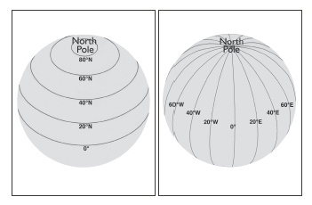
Diagrams showing the lines of latitude and longitude around a globe.
After establishing a common system for the earth, the Chinese next had to establish a common map of the heavens. Each navigator would have had to use the same name for the same star as well as the same star map from which longitude would have been determined.
How the Chinese Fixed the Stars’ Positions in the Sky
In the thirteenth century, the astronomer Guo Shoujing fixed the positions of key stars relative to Polaris (the Pole Star). Polaris appears on an extension of the earth’s axis, billions of miles away above the North Pole. Because of the earth’s rotation, the heavens appear to rotate around Polaris. The farther north one goes, the more of the heavens one can see.
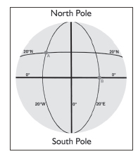
Diagram showing the positions of ships A and B on a globe. Ship A is at 20° N 20° W, Ship B is at 0° N 20° E.
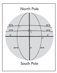
Ships A and B discovering new lands at point C will have the same position for the new land: 10° N 0° E.
In 1964 I was navigator of HMS Narwhal, a submarine operating under the polar ice cap. Now and then we would find clear-water “lakes,” called polynyas, where we would surface in order to fix our position by the stars. The heavens appeared like a vast globe above us. As we approached the North Pole, we seemed to be inside a bowl looking at a hemisphere of stars spreading in an arc down to the horizon all around us.
At the North Pole, the Chinese could fix the position of every star in the Northern Hemisphere relative to Polaris. The stars are so far away that to an observer on earth they never change their positions relative to one another.
The Chinese divided the sky into twenty-eight segments or mansions. Picture an orange with its skin sliced; the cuts start where the orange was fixed to its tree and continue vertically downward. They called each mansion a hsiu. They fixed the position of stars at the top of each of the twenty-eight mansions relative to the Pole Star (ABC).

The Chinese fixed the position of stars at the top of each of the 28 lunar mansions relative to the Pole Star.
Then they fixed stars in the lower part (DEF) of each segment relative to those in the upper part (ABC). Because stars never change their position relative to one another, even if the Chinese were not near the North Pole and hence could not see the stars in the lower part of each segment (because these stars were below the horizon), they always knew the stars’ positions. So they could produce star maps.
They noted the vertical positions of each star below Polaris (none can be above Polaris) and the horizontal position of each hsiu relative to Nanjing (longitude). The Chinese called the vertical height of each star below Polaris “declination” and its position around the equator from Nanjing “right ascension.” So for the stars in the sky, the Chinese had the same system of measurement they used to determine latitude and longitude. This system was called the equatorial system—vastly simpler than the equinoctial system, used in medieval times before Guo Shoujing, which relied on the ecliptic or the horizon. After 1434, Europeans adopted the Chinese system, which remains in use today.
Next, the Chinese needed precise instruments to measure each star’s position. Guo Shoujing provided the tools. A sighting tube was first positioned by pointing it at Polaris at precisely the angle of the observer’s latitude—that is, if the observer was at the North Pole, the sighting tube would be at 90° elevation. On this diagram, the instrument is aligned to Polaris at 39°49' N, the latitude of Beijing. Once positioned, the instrument was bolted down—because if the angle changed from the latitude of the observer, it became useless.
The observer then selected a star, looking at it through another tube attached to a circle marked in degrees. The movement of the tube along the circle gave the number of degrees below Polaris of the selected star (the arc y-z), which is the star’s declination.
The horizontal angle, the angle from Nanjing, was found by rotating the ring around the equatorial circle, which gave the horizontal angle of the star from Nanjing (its right ascension). The position of the star then was entered in the star tables. The Chinese entered 1,461 stars in their tables, a process that required many astronomers and hundreds of years.
Tables were printed and, along with a star map, given to each navigator. Thus all navigators possessed a common system of latitude and longitude to fix their positions on the globe, and an identical map of the heavens, which enabled them to recognize each star.

A torquetum based on the equatorial system, as used by Zheng He’s navigators and pioneered by Guo Shoujing.
How the Star Tables Allowed Longitude to Be Calculated
For the following description, I am indebted to Professor Robert Cribbs, who has tested the method described to prove its efficacy. This method allows longitude to be determined on any clear day without waiting for a lunar eclipse and without sending messages back to the observer in Beijing. It is a much more advanced method than that described in my book 1421 (that method, kindly explained to me by Professor John Oliver and Marshall Payn, is dependent on eclipses of the moon, which do not happen all that frequently).
Professor Cribbs’s method is based on the fact that the earth not only rotates on its own axis every twenty-three hours and fifty-six minutes but also travels in an ellipse around the sun—something Guo Shoujing had worked out back in 1280. The combination of these two movements means there is a slip of four minutes each day between the time when the earth is in the same position relative to the sun (solar time, twenty-four hours) and the time when the earth is in the same position relative to the stars (sidereal time, twenty-three hours and fifty-six minutes). This slip between sidereal time and solar time amounts to one day every 1,461 days, or four years. The effect is that every midnight, twelve hours after the sun has hit its highest point in the sky, a different star will be in line with Polaris than the day before.

This is a typical star map as used by Zheng He and his navigators.
Astronomers in Nanjing observed the night sky for every day of the 1,461-day cycle and noted the star in line with Polaris at precisely midnight. They produced a table of 1,461 days, which was dispensed to navigators. The 1408 astronomical calendar covers 366 days of that cycle. A copy of a page of the 1408 astronomical tables is reproduced later in the color insert of this book.
With the tables in hand, a navigator in, say, the Indian Ocean must know only which day of the cycle it is, which he calculates by the number of sunsets that have occurred since he left Nanjing. If he left Nanjing on day 61 of the cycle and has noted eighty sunsets, then it is day 141. On the tables, he can see that Aldebaran is in line with Polaris on day 141 (to the Nanjing observer).
However, in the Indian Ocean he observes another, unrecognized star in line with Polaris. He consults his star map and confirms from the tables that it is Betelgeuse. He can now make one of two calculations: he can note the difference in right ascension between Aldebaran and Betelgeuse, which will equal the difference in longitude between the observer in Beijing and himself; or he can note the time it takes for Aldebaran to come into line with Polaris. If this is, say, six hours (one quarter of twenty-four hours), then his longitude difference from Beijing is 90 degrees (one quarter of 360°).
For the calculation to be accurate, both the observer in Nanjing and the navigator in the Indian Ocean must be looking due north at Polaris. If they wish to use the second method to calculate longitude, both must have precisely the same midnight. They do this as follows: First they use a vertical stick to measure the sun’s shadow. When the shadow is shortest, the sun is at its maximum height at midday and is due south. Both observers build a trench running due north-south, a trench that can be flooded to see the reflection of Polaris at night and emptied of water to measure the sun’s shadow at midday.
The sun’s shadow when at its shortest can be measured on the trench. To get the precise second, the shadow is sharpened by employing a pinhole camera atop a pole called a gnomon (described on the website). By using identical gnomons and a standardized pinhole camera, the observers in Nanjing and the Indian Ocean can each determine the same due south/north and the same instant when the sun is at its highest—that is, midday. Our experiments described on the 1434 website have shown that they can calculate this to within two seconds. They can now use a standardized clock to calculate midnight, twelve hours after midday. The 1434 website explains how this Chinese clock worked and how, in Zheng’s era, refinements were built to compensate for different temperatures and air pressures, which would otherwise have affected the number of drips coming out of the clock. Thus time was accurate to within two seconds.
Using the water clock, the observer in Nanjing and the observer in the Indian Ocean establish the same midnight. After sunset the trench is flooded and two poles are placed on either side of the trench; a line is suspended horizontally between the poles. Another line is hung vertically so the observer can see the reflection of the vertical string in the water of the trench in line with Polaris. At the instant of midnight, the navigator in the Indian Ocean looks at the star in line with Polaris reflected in the water, which is in line with the string. (In our example, on day 141 this star is Betelgeuse.) His tables for day 141 say that in Nanjing the star is Aldebaran. From that, he can determine his longitude. According to Robert Cribbs, the method is accurate to within two seconds, which amounts to a maximum error of three degrees in longitude, negligible for mapping the world.
This method requires the navigator to be on land. However, Professor Cribbs has also developed a method of determining longitude at sea by using the equation of time of the moon and the angular distance between the moon and a selected star. To deploy this method (see 1434 website) some calculus is required to establish the future position of the moon for the 1,461-day cycle. By 1280, Guo Shoujing had established a system very similar to calculus. The results appeared in his tables and calendar, which were adopted by the Ming in 1384. Consequently, they were available to Zheng He’s fleets, as were tables of declination of the sun.
Thanks to Tai Peng Wang, who brought the matter to my attention, and to the work of Xi Feilong, Yang Xi, and Tang Xiren, who have recently discovered the star maps of Zheng He’s voyages, we know which stars Zheng He’s fleet actually used to determine latitude and longitude on their passage to India. They sailed with the monsoon winds, starting across the Indian Ocean from the northwest tip of Sumatra at Pulau Rondo, now called Banda Atjeh, on October 10, 1432, determining latitude and longitude as follows: “Gauging the vertical positions of the given stars above the horizon in the east, west, north and south, they reached Sri Lanka.” Using Vega, Sagittarius, Gemini, and Poseidon, they arrived at Calicut (11° N, 76° E) on December 10. See the TPW paper “Zheng He’s delegation to the Papal Court at Florence” on the 1434 website.
Finally, how accurate were Zheng He’s navigators? Two answers produce the same result: their measurement of declination at 22°23'30'' (correct to within two miles) and the accuracy of the eye, which can be judged to within a quarter of a degree—the full moon appears large but its diameter is under half a degree (thirty miles).
It is my submission that Zheng He’s navigators were able to calculate latitude to within half a degree, or thirty miles, and longitude to within two seconds, or three degrees. When the fleets arrived in Venice and Florence, their methods of calculating latitude and longitude were transferred to Europeans. In due course, Columbus and Vespucci used them to reach the New World.