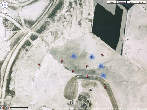
Figure I.1 Waste trackers reporting from a landfill in Arlington, Oregon. U.S. Geological Survey, State USDA Farm Service Agency, reproduced under Google Maps fair-use policy.

Figure I.1 Waste trackers reporting from a landfill in Arlington, Oregon. U.S. Geological Survey, State USDA Farm Service Agency, reproduced under Google Maps fair-use policy.
Urban infrastructures are often characterized as invisible, but this is not entirely true, since they equally capture our imagination. Their complexity is only revealed in partial perspectives, since they consist of such diverse elements as physical installations, the coordinated practices of workers, organizational structures, laws, patents, and regulations.
Chapter 1 investigates tensions in the experience of infrastructure—how the waste system is represented in the data collected by its diverse monitoring mechanisms, and how these representations influence public conflicts around pollution and environmental justice.
The notion of “reading” reoccurs throughout this book. I argue that it is necessary to look at the data representations of infrastructure not merely as encoded facts that can be analyzed as such, but rather as traces that must be interpreted in the context of the material reality of the system and the specific methods of data collection. For example, the GPS location reported by a tracked object might seem like a clear indication of the object’s presence at the reported location, but the causal interpretation of the underlying processes is complicated by many different factors.
The case study presented in chapter 2 examines an experiment to render waste infrastructure legible by observing the movement of different waste streams. The experiment attached location sensors to typical items of trash found in private households throughout the city of Seattle, including beverage containers, papers, shoes and textiles, toys, appliances, obsolete computers, and old cell phones. The goal was to map discarded items as they moved through the waste system and to identify companies, facilities, and logistic networks. From an analytic standpoint, the project aimed at collecting baseline information about waste transportation distances and destinations and investigating how predictably they move. While many aspects of waste logistics are regulated in service contracts and legislation, there is surprisingly little information about how waste actually moves, making it difficult, by traditional means, to address the question of how hauling distances can diminish the benefits of recycling.
The study is based on the MIT Trash Track project, which I was involved in during my time at the Senseable City Lab1 from 2009 to 2013 (Senseable City Lab 2009). The lab is dedicated to studying the possibilities and issues of data and real-time sensing technologies for cities and the urban planning discipline. Early projects of the lab visualized urban activity through the aggregated digital exhaust of cell phone networks and other information infrastructures. The visualizations and data models developed in these projects offered an unfamiliar lens on urban activity through the proxy of mobile communication.
Compared to these projects drawing from existing, but previously unobtainable data sources, Trash Track was radically different, since it focused on a domain where virtually no data existed. The project originated from an exhibition proposal for the 2009 “Sentient City” exhibition curated by Mark Shepard at the New York Architectural League (Shepard 2011). Rex Britter, professor emeritus of engineering at Cambridge University and visiting researcher at MIT, suggested tracking garbage in the city to investigate what Bill Mitchell described as the “removal chain,” a mirror image of the supply chain. The exhibition budget allowed only a small deployment of sensors in New York—not enough to do justice to the vast extent of the system under examination. Through partnerships with companies and public institutions, namely Waste Management Inc., Qualcomm, the city of Seattle, and the Seattle Public Library, it was possible to conduct a larger experiment on the West Coast of the United States. I joined Trash Track in September 2009 to lead the second part of the project after completing the New York exhibition: the deployment of approximately 2,500 waste sensors in Seattle, Washington.
Trash Track was an effort of many individuals. Overall, the project involved more than fifty people, including urban planners, environmental engineers, designers, software and hardware developers, student researchers, and lead volunteers. The deployed sensors reported waste movement over the period of five months, followed by data analysis. It took another two years until the results were published. The publications covered many aspects and disciplines: urban planning implications (Offenhuber et al. 2012), sensor development and pervasive computing (Boustani et al. 2011; Phithakkitnukoon et al. 2013), electronic waste management (Offenhuber, Wolf, and Ratti 2013), and the volunteers’ perceptions of the waste system (Lee et al. 2014).
Through the involvement of volunteers, the project took on a life of its own. Tracking as a way of reading the city and connecting it to one’s personal experience was a recurring theme throughout the experiment. As one participant noted on the Trash Track volunteer survey: “I hadn’t thought about the trash having multiple stops between me and a landfill. I also realized I have no idea where my local landfill is” (Lee et al. 2014).
The volunteers joined the project for different reasons: many were interested in making waste systems more sustainable, while some saw it as a clandestine method to investigate the city’s waste policies. But for many volunteers, the project had a profoundly personal significance, helping them to understand the consequences of their own decisions. In many cases, the participants brought objects of personal significance to follow their last route as trash in the waste stream.
The digital artifacts created by the trackers attached to discarded objects afford a way to experience the waste system through a particular lens. Part I of the book will examine the different ways of experiencing infrastructure through data representations and what role these representations play in public discourse and governance of these systems.