Pioneering Geologist – J Harlen Bretz
Clues to repeated devastation are written all over the landscape of the Pacific Northwest. Although individual flood features rarely provide conclusive evidence for large-scale floods, when examined collectively they tell an amazing tale of repeated cataclysms. It was J Harlen Bretz in 1923 who first proposed an “outrageous hypothesis” that a giant flood produced some very unusual landforms in the Channeled Scabland of eastern Washington. Over the next decade, he meticulously documented his observations and evidence for a “great flood of water” even though he couldn’t explain where the water came from. Early on Bretz used the term “Spokane Flood” to describe the area from where the water appeared to come. During this time Bretz focused his attention on the field relations and geologic evidence for flooding itself, even though he was uncertain of the exact source of water.
Bretz spent much of his career attempting to convince a mostly skeptical geologic community of his Spokane Flood hypothesis. Others in the profession passionately attacked his ideas because they smacked too much of the Bible and were contrary to Uniformitarian principles. Uniformitarianism holds that geologic changes come about from slow, gradual, steady geologic processes – similar to rates we observe today. In short, Bretz’s catastrophic flood was too abominable in other geologists’ eyes at the time. Bretz was adamant in his defense for an Ice Age flood and was resolute that the evidence could not be convincingly explained any other way. Most of Bretz’s critics, who never directly observed the evidence, went to great lengths to dismiss flood features as forming from normal glacial or other non-catastrophic processes.
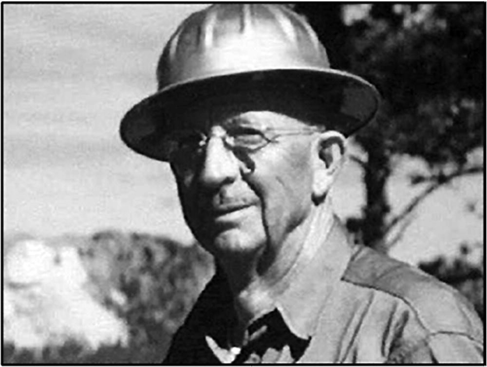
J Harlen Bretz at age 67 (Julian Goldsmith photo)
“The only genetic interpretation yet proposed which is inherently harmonious and which fits all know facts is that of a great flood of water…” Bretz (1927)
Unfazed by his critics Bretz continued to examine and gather evidence for catastrophic outburst floods for four decades. Later, his ideas gained more acceptance based on confirming evidence viewed from the air like expansive fields of giant current ripples visible on aerial photographs within the Channeled Scabland. Elsewhere, evidence for the sudden, rapid draining of glacial Lake Missoula further cemented the Ice Age flood story. Finally, in 1979, only two years before his death, Bretz was awarded the Penrose Medal, the highest honor bestowed by the Geological Society of America. Finally vindicated, perhaps Bretz’s proudest accomplishments were that he was finally viewed as a visionary and that at age 98 he had outlived all his critics.
Thanks to Bretz’s challenge, geologists were forced to objectively reexamine their beliefs and accept that some of the most dramatic landscapes on earth result from short-lived, natural, catastrophic events. Bretz opened the door and inspired other geologists to consider the evidence for other catastrophes that produce dramatic change, such as meteor impacts and volcanic eruptions. Bretz and his theory of the Ice Age floods are testaments for the scientific method and highlight the importance of gathering facts, keeping an open mind, and constantly questioning the dogma of our times.
Since Bretz, many other respected geologists have contributed to our understanding of Ice Age megafloods. Those dedicated scientists and their published works are listed in the bibliography at the end of this book.
Ice-Age-Flood Sources
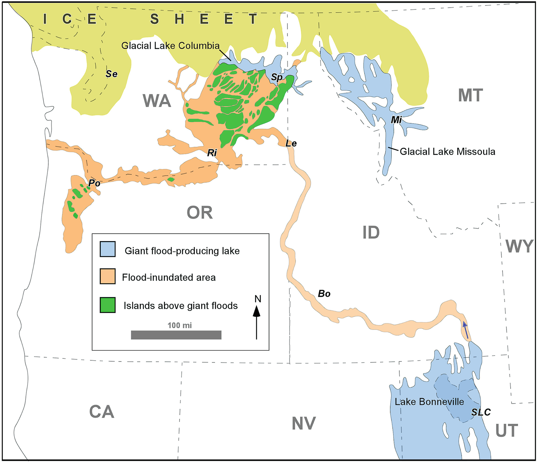
Giant Ice Age floods in the Pacific Northwest came from three different sources: glacial Lake Missoula, glacial Lake Columbia and pluvial Lake Bonneville. (Table 1) Se = Seattle, Sp = Spokane, Mi = Missoula, Le = Lewiston, Ri = Richland, Po = Portland, SLC = Salt Lake City.
Frequencies and relative magnitudes between the three flood sources are summarized in Table 1.
Ice-Age-Flood Sources in the Pacific Northwest. (Derived from O’Connor et al., 2020)
Number of Flood Events During Last Glacial Cycle | Maximum Outflow Volume (mi3) | Maximum Outflow Volume (km3) | Peak Discharge Near Outlet (million ft3/sec) | Peak Discharge Near Outlet (million m3/sec) | Duration of Lake Drainage (days) | Maximum Outburst-Flood Duration (days) | |
|---|---|---|---|---|---|---|---|
Lake Missoula | ~100 | 605 | 2540 | 1024–1235 | 15–30 | ~4 | ~20 |
Lake Columbia | 1 | 118–145 | 55 | ≤35 | ~0.13 | ? | ? |
Lake Bonneville | 1 | 1270 | 5130 | 39–57 | 0.9–1.6 | ~17 | ≥20 |
Glacial Lake Missoula – Up to 100, separate flood events during the last glacial cycle between 15 and 20 thousand years ago.
Glacial Lake Columbia – One flood occurred from the breakup of Glacial Lake Columbia, at the end of the last glacial cycle, about 14,000 years ago.
Pluvial Lake Bonneville – The Lake Bonneville flood entered the Columbia Basin from the east via the Snake River only once. Floodwater from Lake Bonneville downstream of Idaho was mostly confined to the lower Snake and Columbia river valleys – well away from the Channeled Scabland. Furthermore, because the flood lasted a couple weeks or more, instead of a few days like Lake Missoula, it was, by geologic accounts, less devastating even though twice as much water discharged from Lake Bonneville. Unlike the other sources there was no ice dam involved with this flood. It produced only one flood when an alluvial dam was overtopped at a low divide by rising level of Lake Booneville around the peak of the last Ice Age – around 18,000 years ago. During this time more water drained into the lake either because of more precipitation and/or less evaporation. The Lake Bonneville flood occurred between two of the many Lake Missoula megafloods.
A megaflood is considered a flood with a discharge greater than one million m3/sec (>35 million ft3/sec). The largest and most destructive floods clearly came from Lake Missoula – which discharged at >1200 million ft3/sec and, once initiated, drained in only a few days. Lake Bonneville flood lasted much longer (~17 days) but had a much lower discharge (<1.6 million m3/sec) compared to Lake Missoula and therefore was much less destructive. While Lake Columbia flood didn’t officially qualify as a “megaflood” it still produced some significant flood features, like giant current ripples that are on par with the Lake Missoula floods.
Each of three flood sources will be covered separately in the order listed above for the remainder of this publication. Outburst floods for both Lake Columbia and Lake Bonneville, because of their smaller volume and discharge, were mostly confined to a single pathway. These will be examined separately, starting at their source, before covering their paths of destruction downstream.
Megaflood paths for outbursts from the much-larger glacial Lake Missoula, on the other hand, spread out for almost 100 miles across the Channeled Scabland. Flood features within four different scabland tracts (Cheney-Palouse, Telford-Crab Creek, Grand Coulee, and Moses Coulee), will be covered separately starting at the upper end and again moving downstream with respect to the floods.
This book focuses on the more obvious and most dramatic flood features where the evidence is most striking and convincing from the air. However, there are many other features and localities where the evidence for megafloods is more subtle and less visually impactful and therefore not included in this treatise. Again, the reader is referred to the list of previously published works listed in the back.
Foundations
Before diving into the subject of megafloods let’s first establish the foundations upon which the floods imprinted themselves. Before the earliest Ice Age floods there were two older, widespread geologic units in eastern Washington, which huge floods encountered and significantly modified: (1) volcanic Columbia River basalt and (2) wind-deposited Palouse loess.

Areas in Pacific Northwest were first affected by ancient floods of volcanic basalt (gray) and millions of years later by outbursts from glacial Lake Missoula (blue). Basalt lava came to the surface via parallel, deep underground fissures, also known as feeder dikes.
Columbia River Basalt
For more than 10 million years (6.5–17 million years ago), one flow after another of volcanic lava, known as the Columbia River basalt, inundated the region, creating the substrate for the broad, rolling plains of the Columbia Basin. Altogether this included as many as 300 lava flows, spreading out for hundreds of miles and causing the Earth’s crust to sag under the massive weight of dense, basalt lava. Individual flows range up to 300 feet thick. The basalt flows cover about one-third of Washington state as well as large parts of Oregon, extending to Idaho and Nevada. Altogether, these basalts reached their maximum thickness (up to 15,000 feet) near the Tri-Cities area of south-central Washington but thin outward toward the margins.
Flood basalts in the Columbia Basin flowed or sometimes shot out from of many long, vertical and linear fissures mostly located in southeast Washington and northeast Oregon. Today, many of the fissures, or feeder dikes, that delivered lava to surface are visible across the Columbia Basin. Then the molten lava flowed under the influence of gravity toward lowlands to the west and north. Based on distinctive chemical and physical characteristics, some of the same flows that originated in the higher, eastern part of the Columbia Basin can be traced hundreds of miles away to the Pacific Ocean. Basalt flows must have erupted rapidly and were extremely fluid based on: (1) the lack of any significant buildup by volcanic debris along the vents, and (2) distance traveled by many of the flows (i.e., hundreds of miles) before cooling and solidification. Apparently, an insulating, hardened crust developed at the top and bottom of each flow, which allowed the molten interior to continue flowing and spread outward for long distances.
The internal vagaries of basalt flows had a profound effect and played a significant role in how they were eroded by the Ice Age floods and the types of features and landforms left behind. A universal characteristic of basalt flows are fractures, or joints—shrinkage cracks that developed as the molten lava cooled, contracted and solidified. Some of the thicker basalt flows may have taken as long as 50 years to cool and solidify.

Basalt flows at the base of this exposure are ~16 million years old – the youngest is 8.5 million years old. Many more flows lie buried below the level of the Columbia River.
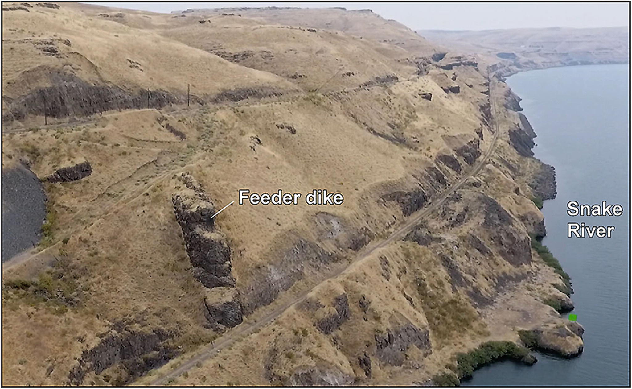
Vertical fissure filled with Columbia River basalt cuts across several older lava flows along the Snake River. Dike was later exposed by downcutting of the river followed by erosion via Missoula floods.
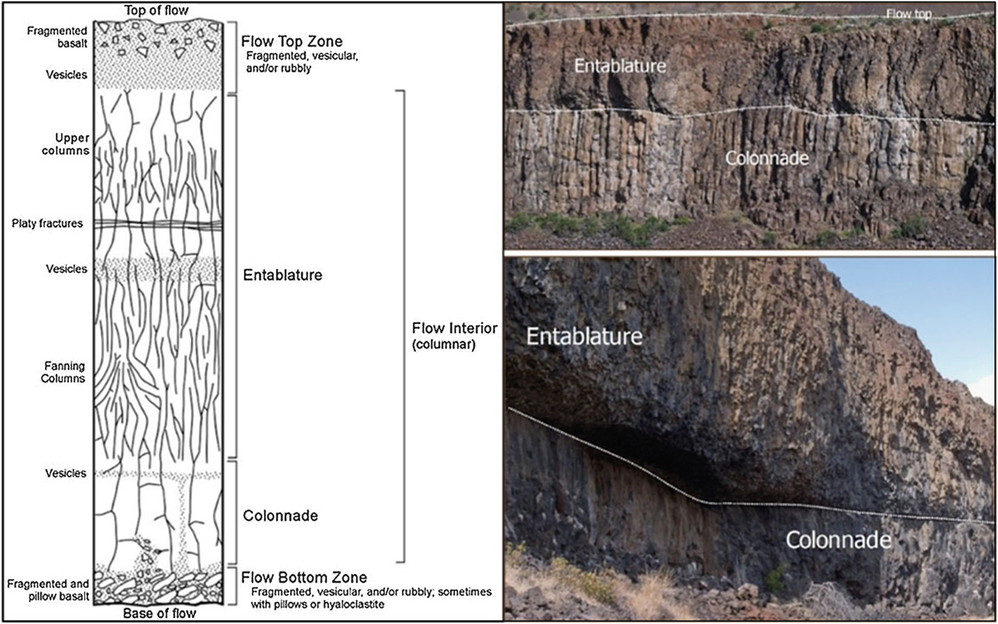
Considerable variation exists within and between individual basalt flows, but most of them are composed of at least two subunits: entablature and colonnade. Powerful Ice Age floods often preferentially eroded away larger blocks of basalt within the colonnade. The entablature proved to be more resistant to flood erosion producing rock overhangs like that above.
Towards the top of the flow, where cooling occurred more rapidly, a higher density of cracks developed in a random pattern called the “entablature” zone. Deeper within the same lava flow, where the lava was insulated beneath the hardening entablature zone, the lava remained molten for a longer period of time, and thus the basalt cooled more slowly. This allowed the growth of larger, more regular fractures that created a honeycomb-like network of polygonal columns referred to as the “colonnade”. The cracks started at the base of the molten flow interior and slowly propagated upward towards the interior of the cooling lava flow. The end results are almost-continuous vertical columns spanning the entire breadth of the colonnade. Rubbly zones of broken-up rock may also be present both at the very tops and bottoms of flows. Oftentimes, spherical voids are concentrated near the tops of individual lava flows. These represent gas bubbles, frozen in place, during cooling of the molten lava flow.
Palouse Loess
Prior to the Ice Age floods, most of the Channeled Scabland was covered by a blanket of windblown sediment (loess) deposited onto rolling Palouse Hills across much of eastern Washington. The loess deposit began forming as predominantly southwest winds blew sediment up onto the Palouse Slope at the beginning of the Ice Age perhaps as far back as 2.6 million years ago. The earliest floods eroded this sediment and transported it downstream where it was redeposited in the slackwater Pasco, Othello and Quincy basins, when floodwaters backed up behind Wallula Gap. The dust storms were especially intense and effective at transporting sediment after each outburst flood, which removed and/or covered over the anchoring vegetation. Thus, the fresh blanket of flood sediment was easily picked up by the wind and carried back toward the Palouse region. The Palouse hills, then, are the end result of back-and-forth winnowing of flood sediment by desert winds over the last couple of million years.
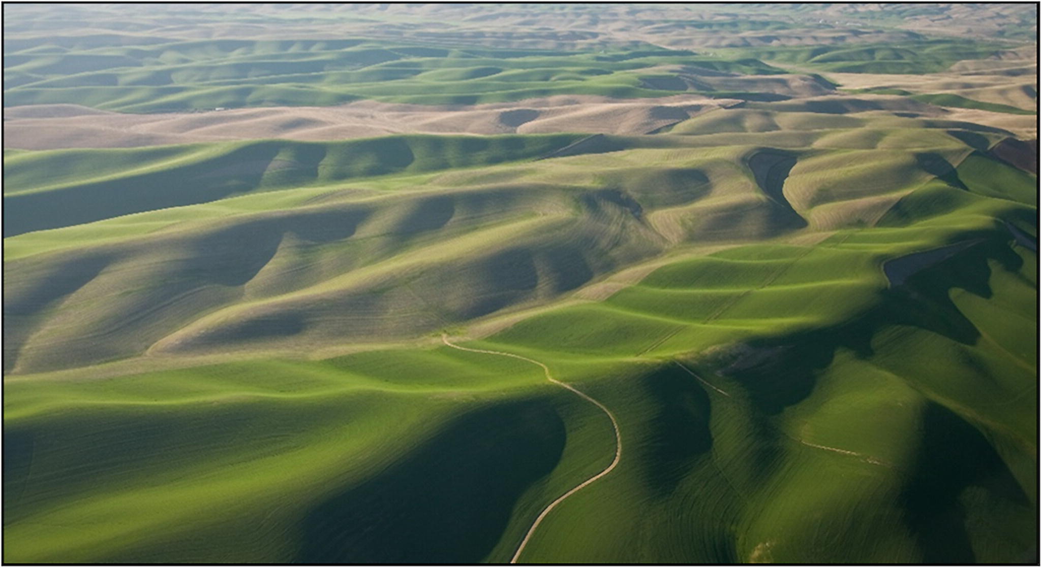
Prior to Ice Age megafloods much of eastern Washington looked like this. These rolling Palouse hills, east of the Channeled Scabland, completely escaped erosion by the Missoula floods. Preserved is the gentle dendritic drainage pattern characteristic these mature hills of slowly accumulating windblown dust.
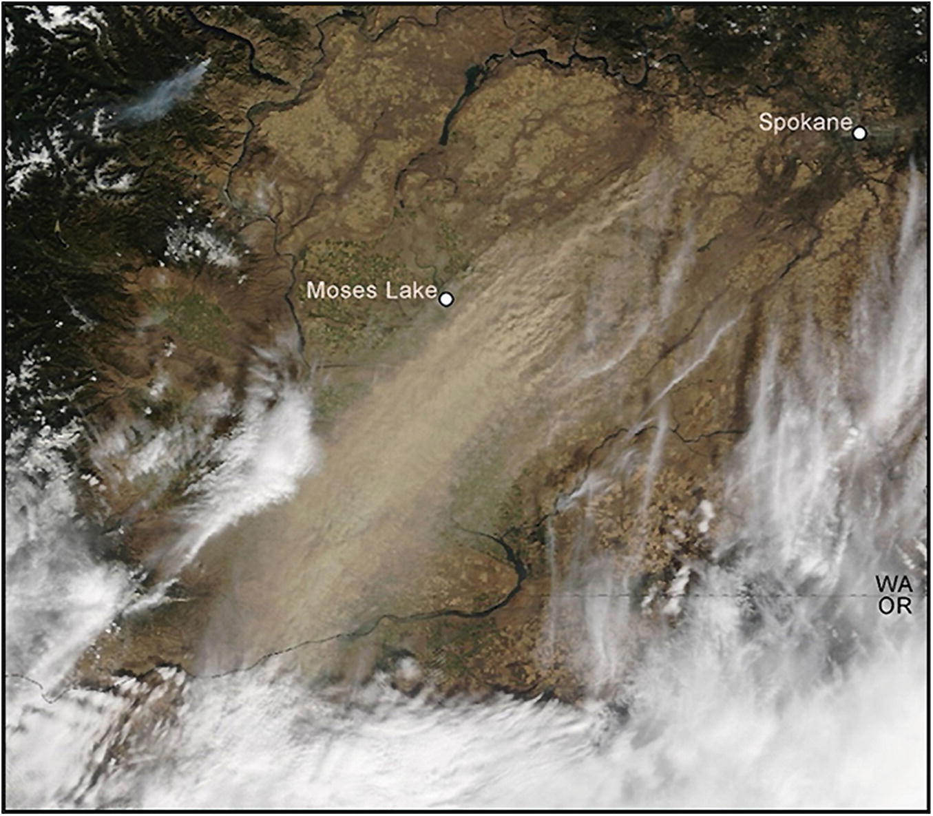
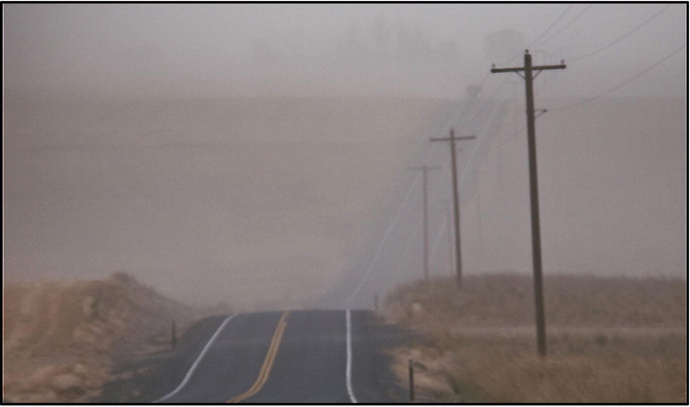
Satellite view of recent storm kicking up a brown cloud of dust (loess) that spreads out across the Channeled Scabland. Next page: Repeated periodic dust storms like these are responsible or the accumulation of up to 250 ft of loess over the last ~2 million years.
Earliest Ice Age Floods
With the close of basalt volcanism, about 6.5 million years ago, only a few more million years elapsed before the region succumbed to a new era of flooding, this time of icy glacial meltwater. The Ice Age began with a period of distinct climatic cooling at the beginning of the Pleistocene Epoch, about 2.6 million years ago. The geologic record of flooding is best preserved for the last glacial cycle. Much less evidence exists for the earliest floods since the last floods tended to erode or cover up the evidence for older floods.
For at least the last million years or so, the Earth’s climate has cycled between major periods of glacial advance and retreat, going through a complete cycle about every 100,000 years. While there is some evidence for floods going back a million years or more, most of that evidence was buried or destroyed by the last floods, which occurred during the last glacial cycle between 14 and 20 thousand years before present.
How do we know how old the floods are? One way geologists can identify the land record of old floods is by looking at the magnetic polarity of fine grained deposits that was imprinted onto the sediment as it was laid down. The Earth’s magnetic field has periodically and randomly “flipped” back and forth over geologic time. The last significant reversal occurred about 780,000 years ago, when the magnetic field changed from a “reversed” direction to the “normal” direction we observe today. These changes often are preserved in sediments since some sediment grains are magnetic and, like tiny magnets, tend to align themselves with the Earth’s magnetic field at the time they are deposited. So, early Pleistocene flood deposits retain a reversed magnetic polarity while middle Pleistocene and younger deposits record a normal magnetic polarity.
Evidence for the oldest floods on land can also be found by examining how flood deposits have weathered at the surface over time. Deposits from the last floods, which are relatively young (14,000–15,000 years), show little or no weathering. In contrast, old flood deposits exposed to the elements for a much longer time display extensive weathering. In a semiarid climate, like that of the Channeled Scabland, buried soils that developed on old flood deposits are rich in a calcium-carbonate precipitate – called caliche – that takes many thousands of years to accumulate into a hardpan.
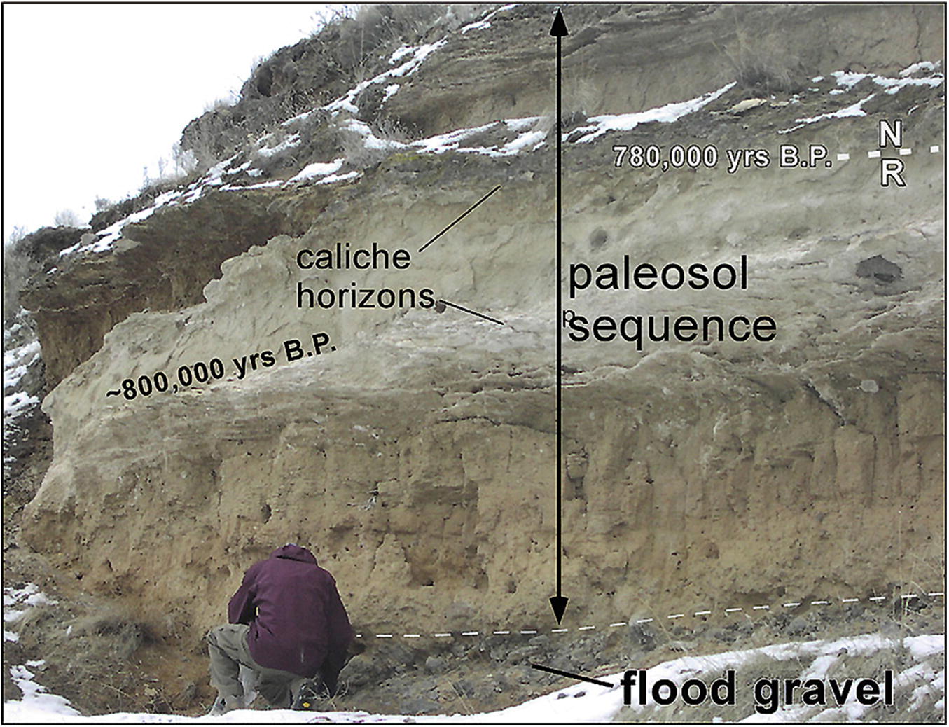
An outcrop exposure amongst the streamlined Palouse hills at Marengo (pictured) is one of only a few places for evidence of very old floods going back one million years or more. Here is preserved the stratigraphy of an extremely old deposit of flood gravels, which lies at the base of the exposure - beneath a thick sequence of old soil horizons (caliche paleosols) developed in loess. Windblown loess within lower paleosols, above the flood gravel, retain a normal (N) over reversed (R) magnetic polarity locked in at the time of sediment deposition. The age of this world-wide magnetic reversal has been dated elsewhere at 780,000 years B.P. A radiometric (thermoluminescence) age of 800,000 years B.P. from sediment below the magnetic reversal is consistent with the magnetic-polarity age. Since the flood gravels lie below the dated horizons, it follows that an Ice Age flood that occurred more than 800,000 years ago is preserved at this site (Bjornstad et al. 2001).
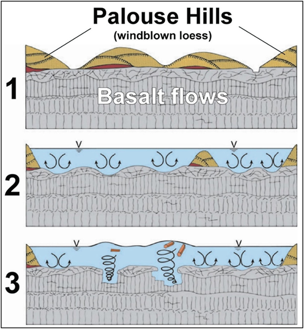
Stage 1: Before Ice Age floods a thick blanket of windblown Palouse loess covered a stacked sequence of layered basalt lava flows. Stage 2: Early floods begin to erode the Palouse cover off the basalt bedrock leaving behind eroded, streamlined hills of loess. Stage 3: More erosion during subsequent floods strips away more Palouse loess while carving grooves, channels and rock basins deeper into the basalt bedrock. Modified after Baker (2009b).
Unfortunately, evidence of the earliest floods is limited to a few, isolated, widely distributed places in the region. Within the Channeled Scabland almost all the evidence for the much older floods is preserved in the Cheney-Palouse Scabland Tract. Perhaps, as more roads and excavations expose new outcrops of flood deposits, more evidence for old floods will be uncovered to help work out the chronology for the earlier Ice Age floods. But the Rosetta stone for the timing and frequency of Ice Age megafloods lies off the Pacific coastline where a continuous record of flooding is likely preserved. Perhaps someday a carefully placed borehole will reveal the complete picture of 2 million years or more of Ice Age floods’ history.
The earliest floods likely began to erode into Palouse loess, leaving behind teardrop-shaped islands known as “streamlined Palouse hills” upon the Channeled Scabland. Turbulence associated with high-energy floodwaters cut deeper and with each successive flood eventually breached the loess cover and eroded further into the underlying layers of basalt bedrock.
After being eroded by the floods, some of the sediment collected along the downstream ends of obstructions or up into backflooded valleys along flood paths or in some of the valleys downstream. Not all the eroded sediment came to rest in these basins, however. Most remained mixed with the turbid floodwater and were quickly flushed out to sea with each of the hundreds or more, short-lived, outburst-flood events.
As one might imagine, the windblown Palouse loess and Columbia River basalt are two very different types of material and eroded very differently. The fine-grained, semi-cohesive loess eroded grain by grain, primarily by abrasion. Furthermore, surfaces of Palouse loess are relatively smooth and do not induce strong erosive turbulence in the floodwaters. In contrast, basalt surfaces are rough, a situation that promotes turbulence when engulfed in racing floodwaters. And even though it is hardened rock, basalt is riddled with cracks that formed long ago as the lava cooled. Cracks, or fractures, created weak spots where floodwaters could easily pluck out basalt blocks en masse. So, even though basalt was rock, the floodwaters ended up eroding it faster and more easily than the relatively “soft” loess deposits that lay on top of the basalt. This explains the phenomenon of why “islands” of streamlined Palouse loess were able to withstand repeated attacks by the floods, even out in the middle of high-energy scabland flood channels.
Where the floods were especially powerful and eroded into basalt, they left behind a topography referred to by Bretz as “butte and basin,” which characterizes much of the Channeled Scabland. In places, the floods scoured long, straight grooves in the basalt bedrock. As grooves expanded, the floods gouged out potholes that merged and coalesced into larger rock basins.
As erosion continued, vertical walls of basalt called cataracts (now dry waterfalls) receded upvalley, leaving behind deep, steep-walled, coulees below the cataract cliffs. Scalloped, horseshoe-shaped cataracts, often dividing into two or three alcoves, receded upvalley for miles. Later floods might continue to widen the channels, cutting deeper into the basalt, creating multiple tiers of recessional cataracts and inner canyons.
After removal of the cover of Palouse loess, the many unique erosional landforms of the Channeled Scabland are as much the result of the Columbia River basalt bedrock as they are about the floods themselves. Multiple layered basalt flows with regular, alternating fracture patterns between entablature and colonnade were conducive to the preferential plucking and rapid disintegration of the basalt flows, especially along columnar zones. This promoted the rapid deepening and undercutting of basalt flows during flooding, leading to the formation of potholes, recessional cataracts, rock benches, blades, mesas and buttes. In contrast, none of these types of landforms developed in granitic or other rocks along the flood route. Therefore, it was the combination of the floods and the unique erosional behavior of the basalt that created the characteristic landforms of the Channeled Scabland.
Routing of Outburst Floods
During the last glaciation, which ended in eastern Washington ~13–14 thousand years ago, fingers of the Cordilleran Ice Sheet crept south across the northern border of the United States into Washington, Idaho and Montana. These glacial ice lobes blocked river drainages, including the Clark Fork near the Idaho-Montana border. The blockages created huge, ice-dammed lakes. The largest of these was glacial Lake Missoula, which extended 200 miles east, creating an inland sea of fresh, glacial meltwater equal to half the volume of Lake Michigan. The ice dam that created the lake was located over what is now Lake Pend Oreille in northern Idaho. Glacial Lake Missoula was up to 2000 feet deep and covered 3000 square miles of western Montana.
Flowing water naturally follows the path of least resistance and the Ice Age floods were no exception. After their escape from Lake Missoula, the floodwaters naturally followed low points in the landscape. The last floods from Lake Missoula raged first through Rathdrum Prairie, a mountain valley between what is now Sandpoint, Idaho and Spokane, Washington. Because Lake Columbia was already in place for most Missoula floods, floodwaters quickly finished the job of filling the Columbia valley behind the Okanogan Lobe ice dam. Upon reaching the brim of the valley, the floodwaters spilled over several low divides to the south and onto the area of today’s Channeled Scabland. During most of the last glacial cycle the Okanogan lobe effectively stopped any Missoula floods from continuing down the Columbia valley west of Grand Coulee. Thus, flood after flood from Lake Missoula repeatedly swept through creating and eroding the Channeled Scabland. Evidence suggests that one or more Missoula floods early in the last glacial cycle continued west all the way down the Columbia Valley, instead of across the Channeled Scabland at a time when the Okanogan Lobe had not yet fully extended across the Waterville Plateau.
After filling the Columbia Valley behind the Okanogan lobe, Missoula floodwaters spread across the Channeled Scabland and Mid-Columbia Basin via three main paths: (1) Grand Coulee, (2) Telford-Crab Creek and (3) Cheney-Palouse Scabland Tracts. A fourth route, Moses Coulee, also was used when the Okanogan lobe was not fully advanced. Combined, the floods’ path across the scablands, from edge to edge, spreads out for 100 miles! Depending on the size of the flood, it may have occupied one or many of the scabland routes at the same time. Once the flood-channel network was established early in the Ice Age, later floods followed the same routes, sometimes perhaps with only minor changes.
Floodwaters that spilled over into the Cheney-Palouse tract headed almost straight south across the Palouse Slope, eroding the land down to basalt bedrock and stripping away up to hundreds of feet of Palouse loess. Much of this water drained into the Palouse and Snake rivers, while the remainder went west down Washtucna Coulee to join floodwaters coming from Grand Coulee and the Telford-Crab Creek tract.
Within hours, floodwaters from all three paths converged onto the central Columbia Basin near Pasco. But there was too much water for all to flow through the one and only outlet at Wallula Gap. The gap was too narrow and basalt ridges along the gap were too high for the floodwaters to cross over, so they backed up and created a huge temporary lake called Lake Lewis. For several days, this lake filled the mid-Columbia basin, backflooding up into the Yakima and Walla Walla valleys. In the Tri-Cities, only the crests of the higher ridges poked out above the lake that was up to 900 feet deep!
Recent computer models indicate Lake Missoula completely drained within four days or less of ice-dam breakup while the floodwaters took up to three weeks to find their way to the Pacific Ocean. (The delay in drainage was the result of temporary pooling behind several hydraulic constrictions starting at Wallula Gap and continuing through the narrow Columbia Gorge). After each flood the Cordilleran Ice Sheet continued to advance, and within a few years the ice dam began to re-block the Clark Fork River, initiating a new Lake Missoula.
The timing and frequency of climate change and glacial periods are well-preserved in sediment cores collected at depth in the Pacific Ocean. Here sediments have been laid down uninterrupted for millions of years and there is a continuous record of at least nine major glacial-interglacial cycles over the last 800,000 years. As many as several dozen of these glacial climatic cycles may exist going back to the start of the Ice Age, which began about 2.6 million years ago. Some geologists believe as many as 100 floods occurred during the waning stage of the last glacial cycle alone. If that’s the case and if as many floods occurred during previous glacial cycles as the last, then the total number of floods for the entire Ice Age could easily add up to hundreds or even a thousand or more!
Another source for Ice Age flooding occurred ~18,000 years ago, near the peak of the last Ice Age, with a single flood from Utah’s Lake Bonneville. Floodwater began to escape from the enclosed basin here at a low point for the lake at Red Rock Pass. At first, the lake overflowed slowly as it eroded into loose sediment of an alluvial fan complex shed off the surrounding mountains. Once started, however, erosional acceleration of the lake waters rapidly cut a channel through the alluvial dam. The ensuing flood lasted for about two weeks until floodwaters cut a 400-ft deep channel across the pass. Then the flood shut down upon encountering the resistant bedrock below. Altogether half the volume (~5200 km3) of Lake Bonneville, flowing at up to one million m3/sec, escaped through the pass.
Lastly, about 14,000 years ago, several hundred years after the last outburst flood from glacial Lake Missoula, there was one more flood. This flood occurred as the retreating Okanogan Lobe broke apart releasing the contents of glacial Lake Columbia. The Okanogan Lobe blocked the Columbia River near today’s Grand Coulee Dam. With the ice dam created by the Okanogan lobe breached this last flood was restricted to the Columbia Valley, which totally bypassed the Channeled Scabland of eastern Washington. Unlike Lake Missoula, glacial Lake Columbia did not repeatedly fail on its own. Perhaps it was because Lake Columbia was a shallower lake (maximum 1500 ft deep) in contrast to Lake Missoula (more than 2000 ft deep). Perhaps the reduced buoyancy and pressure behind a shallower Lake Columbia might have kept pressurized water from destabilizing the ice dam.