8 HERMAN CREEK
DISTANCE & CONFIGURATION: 6–20 miles, out-and-back or loops
DIFFICULTY: Easy–strenuous
SCENERY: Old-growth forest, a clear stream, waterfalls, views of mountains and the gorge
EXPOSURE: Almost all shaded, with one optional bit of very exposed rock
TRAFFIC: Moderate on weekends, light otherwise
TRAIL SURFACE: Dirt, rocks
HIKING TIME: 2 hours–2 days
ELEVATION CHANGE: 1,000'–5,070'
SEASON: Year-round for the lower hikes, but snow possible; Nick Eaton Ridge likely snow-free April–November
BEST TIME: April–May, October
BACKPACKING OPTIONS: Fantastic
DRIVING DISTANCE: 46 miles (1 hour) from Pioneer Courthouse Square
ACCESS: Northwest Forest Pass required at summer trailhead only
MAPS: National Geographic Columbia River Gorge, Green Trails Map 428S (Columbia River Gorge–West)
WHEELCHAIR ACCESS: No
FACILITIES: Restroom and water at summer trailhead; water turns off when campground closes around Labor Day.
CONTACT: Columbia River Gorge National Scenic Area, 541-308-1700, www.fs.usda.gov/crgnsa
LOCATION: Herman Creek Trailhead on Herman Creek Road, 3 miles east of Cascade Locks, OR
COMMENTS: In winter and early spring, you’ll have to park 0.5 mile down the access road at the gate; parking is free there, but it adds a mile to your day. Also, this is another area affected by the 2017 Eagle Creek Fire; check gorgefriends.org or oregonhikers.org for the latest conditions.
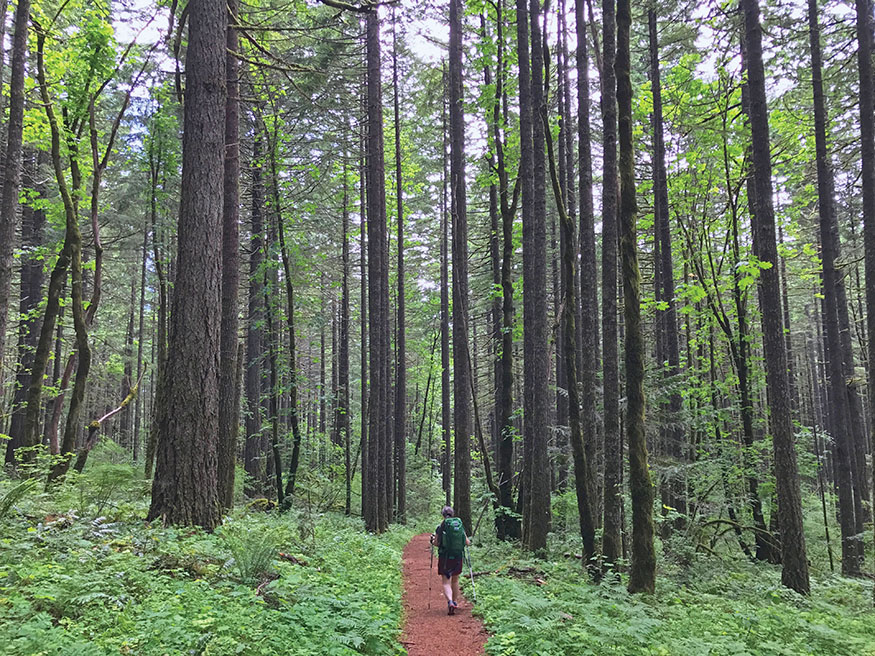
Forest grandeur on the Gorton Creek Trail just above Herman Camp
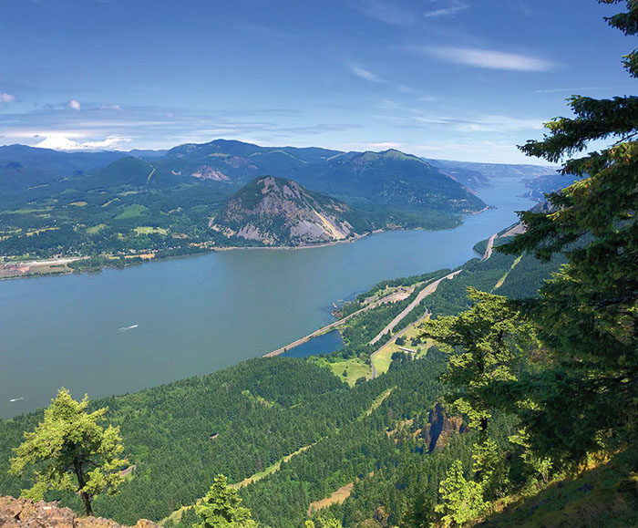
THE HIKING HUB at Herman Creek offers something for everyone: a midwinter riverside stroll, a spring get-in-shape workout, or a long summer backpack hike. The prize of the area, though, is Indian Point. That’s the hike shown on the elevation profile; none of the others described here are nearly as steep as this one.
DESCRIPTION
Every spring, at some point, most of us trail hounds will wind up at the Herman Creek trailhead; whatever you’re looking for, you can find it on these forested slopes. So, rather than one hike, here are a few options, from easiest to hardest, with enough variations that you may not know which to choose—and that’s why so many of us return to Herman Creek time and time again.
All the hikes start at the same place, the Herman Creek trailhead, which until May 1 will mean a 0.5-mile walk from Forest Lane to the trailhead. From the trail sign, hike a short, steep section to some power lines, and follow the trail past them, for a total of 0.6 mile, to a junction. The options start here, as do the mileage counts.
Pacific Crest Falls and the Pinnacles (4.1 miles, 1,000', easy)
From this junction, turn right and descend 0.4 mile to cross Herman Creek on a large metal bridge. This creek does get runs of anadromous fish (which live in the ocean and spawn in the rivers). Steelhead enter from June through October, and salmon are in from August to November. Perhaps you can spot one of these, or the large trout that inhabit the deeper pools.
Beyond the bridge, climb again 0.8 mile to reach an intersection with the Pacific Crest Trail (PCT). Turn right here, pass through a rockslide, and in 0.5 mile arrive at the two-tiered Pacific Crest Falls, which is much more impressive in winter and spring than in summer or fall.
Continue 0.2 mile and you’ll catch a glimpse of the Herman Creek Pinnacles, basalt cones that can be tough to spot through summer brush.
To add a bit more, hike another 1.5 miles along the PCT to Dry Creek, which isn’t dry. A side trail leads 0.2 mile to the equally wet Dry Creek Falls. You could even stash a car at Bridge of the Gods and make this a one-way hike.
Herman Creek Trail (up to 22.2 miles and 5,070', moderate–strenuous)
Herman Creek leads to several side trips, many nice places, and one spectacular destination. Best of all, the average elevation gain here is a paltry 350 feet per mile.
From the same junction referenced above, continue uphill and to the left, and you’ll climb (briefly on a road) 0.7 mile to reach Herman Camp and a big trail intersection. From left to right, the trails are Gorge Trail, Gorton Creek Trail, and Herman Creek Trail. (If you’re looking for a campsite, you can do a lot better than Herman Camp.)
Keep climbing Herman Creek Trail, which still looks like a road, and in 0.3 mile you’ll pass the Nick Eaton Way junction (more on that later). After this, your trail begins a lazy climb in and out of small side canyons, though not yet near Herman Creek. Over the course of 2.4 miles, you’ll pass a series of creeks and waterfalls until, at 4 miles total (3.4 since the first junction), you’ll hit Casey Creek Camp and two trails.
For your first real view of Herman Creek on this hike, head down and to the right for a steep 0.3 mile to the confluence of Herman Creek’s east and west forks. It’s a fine place to have lunch and turn around for an 8-mile round-trip stroll.
For a major workout, go up Casey Creek Trail for 2.1 leg-killing miles that gain 2,540 feet. That gets you to Nick Eaton Trail; turn left and trace it back to the junction you just passed. That loop is only 11.3 miles with 4,035 feet of gain.
Farther along Herman Creek Trail, you’ll pass more creeks and falls over the next 3.5 miles (notice a pattern?) and arrive at Cedar Swamp Camp, the first of three campsites in 0.5 mile. Things start to open up a bit here, and 3 more miles (a total of 11 since the car) put you at the PCT just below Chinidere Mountain and just above Wahtum Lake, where campsites and deep, blue water beckon. From Wahtum Lake, you could go back via Eagle Creek Trail for a spectacular two- or three-day backpack.
Nick Eaton Way to Indian Point (8 miles, 2,800', strenuous)
This is the pick of the area, at least for day hikers up for some “up.” Nick Eaton Way (named for a pioneer-era farmer) is among the steeper paths around. I often use it to see what kind of shape I’m in by April; usually the answer is “not good.”
From its start at Herman Creek Trail just above Herman Camp, Nick Eaton Way climbs 1,960 feet in 2 miles, making it steeper than Dog Mountain. But hey, it’s only 2 miles, and along the way you’ll traverse hanging meadows with flowers and great views. The meadow at 1 mile has a view down the Columbia to Bonneville Dam and Bridge of the Gods; another meadow, 0.2 mile on, has a rare view south—in this case, up Herman Creek’s drainage.
After 2 miles of this, you’ll enter Hatfield Wilderness and hit Ridge Cutoff Trail. Your path here is on the left, but if it’s clear, it’s worth staying on Nick Eaton Way 0.25 mile and looking for an unofficial but clear trail heading up to what’s known simply as Peak 3,152 (its elevation). The view is better than the name, and it’s a great lunch spot.
To continue the loop, take Ridge Cutoff Trail 0.6 mile to Gorton Creek Trail, where you have more choices. One option is to turn right and hike 6.5 miles, passing various camps and trails in a swing around to Wahtum Lake. The first campsite you encounter is Deadwood Camp, 0.8 mile along, which has a year-round stream.
If you’re feeling slightly adventurous, your second option is to go about 50 yards right, then look for a seriously steep trail descending to the left. This path goes out toward Indian Point, a dramatic rock outcrop hundreds of feet above the Columbia. It’s about 0.25 mile down to a flat spot at the base of the point; going any farther is enthusiastically discouraged if you have even the slightest fear of heights or lack of balance.
Back on Gorton Creek Trail, hike 2.6 mellow, lusciously green, big-tree-filled miles to Herman Camp, then turn right on Herman Creek Trail to return to the official trailhead after hiking another 1.3 uneventful miles.
NEARBY ACTIVITIES
Last I’ve seen, this trail wasn’t getting too crowded, but if it is, here are a couple of options, both in the field guide at oregonhikers.org. If you want another forested river walk, check out Tanner Creek. If you want a big climb to a great view, head for Wauna Point. Also understand that all of those, like Herman Creek, were hit pretty hard by the fire in 2017.

GPS TRAILHEAD COORDINATES N45° 40.92' W121° 50.52'
DIRECTIONS From Portland, take I-84, driving 37 miles east from I-205 to Exit 44 (Cascade Locks). Proceed through the town 3.2 miles, cross back under I-84, and stay straight onto Frontage Road. Go 1.7 miles and turn right onto Herman Creek Road, and follow that 0.3 mile to the trailhead. If the gate is closed down at Forest Lane, park there and walk up.