23 BAGBY HOT SPRINGS
DISTANCE & CONFIGURATION: 3-mile out-and-back to springs, 3.6-mile out-and-back to Shower Creek
DIFFICULTY: Easy
SCENERY: Old-growth forest, mountain stream, wooden tubs of hot water
EXPOSURE: Shady
TRAFFIC: Heavy
TRAIL SURFACE: Packed dirt and crushed rock with some muddy spots in winter and spring
HIKING TIME: 2 hours (plus time for a soak)
ELEVATION CHANGE: 200'
SEASON: March–November; sometimes open in winter, but call ahead for conditions.
BEST TIME: Weekdays April–October
BACKPACKING OPTIONS: Several (crowded) sites just past the springs, with many more up in the wilderness
DRIVING DISTANCE: 67 miles (1 hour, 45 minutes) from Pioneer Courthouse Square
ACCESS: No charge just to park and hike; $5 soaking permit (cash only) can be bought at the trailhead or from the store at Ripplebrook on the way.
MAPS: USFS Bull of the Woods Wilderness, Green Trails Map 524 (Battle Ax)
WHEELCHAIR ACCESS: No
FACILITIES: Pit toilets but no water at trailhead
CONTACT: Clackamas River Ranger District, 503-630-6861, www.fs.usda.gov/mthood
LOCATION: Bagby Hot Springs Trailhead on Forest Service Road (FR) 70, 39 miles southeast of Estacada, OR
COMMENTS: Don’t leave any valuables in your car at this trailhead.
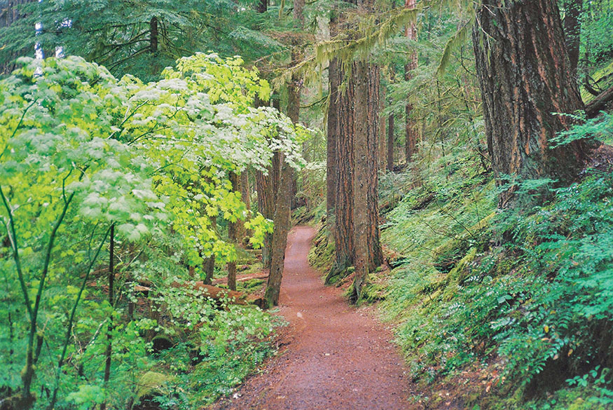
The wide, flat Bagby Trail winds through amazing old-growth forest.
UNLESS YOU’RE UNCOMFORTABLE being among naked people, this is one place you should absolutely visit, and even if you are, just avoid the bathhouses. The hike isn’t much of a challenge, but it passes through sublime ancient-growth forest. And the springs feature cedar-log tubs, some of them private. It can get very busy on weekends (though alcohol is now banned at the springs), and an attendant at the trailhead lot should help reduce car break-ins.
DESCRIPTION
It seems that everybody in the area knows about Bagby, even those who have never been here. The name itself seems to stand for something about life in the Pacific Northwest: soothing, relaxing, a retreat from the hustle and bustle, a journey back to the days of the ancient forest and natural elements.
Well, it’s not just that. It can get a little crazy on weekends, and the chances you’ll be the only one there on any given day are slim. On weekends, you might have to wait to get your soak, unless you start early. If so, just wander around and enjoy the absolutely magnificent forest surroundings.
From the trailhead parking lot, start up the wide trail and cross the bridge over Nohorn Creek, named for an early pioneer in the area. The hiking is pleasant, the river pools inviting, and the forest inspiring. You might notice some old metal loops tacked high in the trees; those once held telephone wires that connected fire lookouts back in the 1930s. Cross a bridge over Hot Springs Fork Collawash River, and you’re almost to the springs.
When you come to the springs area, the first thing you’ll notice is the 1913 ranger cabin, which is listed on the National Register of Historic Places but isn’t open to the public. It was a central communications station for those fire lookouts and housed firefighters in season. I should mention that this cabin of 16-inch cedar logs was hand-built by one ranger, Phil Putz, who first visited the area after walking 39 miles in one day. Do you think he was happy to arrive at the springs? The path behind the cabin leads to a monumental downed tree; check out the inside, which rotted away long before the giant was felled to keep it from squashing the bathhouses.
The bathhouse on the right has one big tub, with room for five or six adults. The one on the left has an open area with several tubs and five private rooms, each with a two-person log tub. The water comes out of the springs at 136°F and runs through a system of log flumes. To fill a tub, you just open up the valve and let the hot water in, then grab a bucket, fill it with cold water from a nearby tub, and get the temperature where you want it. Typically, a full tub needs four or five buckets of cold water to make it tolerable. As it cools off, just open up the valve and let some more hot water in. It’s fantastic. Many bathers don’t wear swimsuits, but outside the private rooms you’re supposed to. With a private concessionaire in charge, this seems to be running better recently. If people are waiting, you’ll also be asked to limit your soak to 1 hour.
Even if there’s nobody around when you get to the springs, consider taking some time to explore farther up the trail before you soak. It’s old growth all the way, up Hot Springs Fork, past Shower Creek and Spray Creek, and eventually into Bull of the Woods Wilderness. You should go at least as far as Shower Creek (0.3 mile past the springs and just 0.1 mile past a camping area on the right) to enjoy the 50-foot falls and a little wooden platform somebody built underneath it so that folks could take a shower. Beyond that, the trail continues 6 miles and ascends 1,800 feet to reach Silver King Lake, in the heart of the wilderness. Trails fan out from that area to many other great locations.

GPS TRAILHEAD COORDINATES N44° 57.440' W122° 9.594'
DIRECTIONS Take OR 224 from Portland, traveling 44 miles southeast of I-205, through the town of Estacada, to the ranger station at Ripplebrook. Turn right on FR 46, drive 3.6 miles, and make another right, onto FR 63. Drive 3.5 miles and turn right on FR 70. The trailhead is 6 miles ahead, on the left.