33 ELK MEADOWS
DISTANCE & CONFIGURATION: 2-mile out-and-back Newton Creek, 5.5-mile out-and-back to Elk Meadows, 12-mile loop to see it all
DIFFICULTY: Moderate to Elk Meadows, strenuous to Gnarl Ridge
SCENERY: Meadows, mountain streams, extreme close-ups of Mount Hood, fire-recovery area
EXPOSURE: In and out of the trees, with two bridgeless creek crossings
TRAFFIC: Moderate on summer weekends, light otherwise
TRAIL SURFACE: Dirt, some roots and rocky areas
HIKING TIME: 3.5 hours to Elk Meadows, 8 hours for the whole loop
ELEVATION CHANGE: 1,200' to Elk Meadows, 2,460' to Gnarl Ridge
SEASON: July–October
BEST TIME: August and September
BACKPACKING OPTIONS: Several good ones
DRIVING DISTANCE: 69 miles (1 hour, 30 minutes) from Pioneer Courthouse Square
ACCESS: No fees or permits required
MAPS: Green Trails Map 462 (Mount Hood), USFS Mount Hood Wilderness
WHEELCHAIR ACCESS: No
FACILITIES: Outhouse at trailhead; water on trail must be treated.
LOCATION: Elk Meadows and Sahalie Falls Trailhead on Elk Meadows Trailhead Road, 10 miles east of Government Camp, OR
CONTACT: Hood River Ranger District, 541-352-6002, www.fs.usda.gov/mthood
COMMENTS: This makes an excellent snowshoe or ski trip; start at the Clark Creek Sno-Park on OR 35. The Green Trails map shows winter trails.
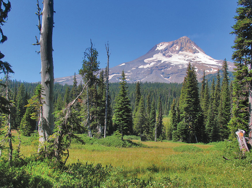
Mount Hood from Elk Meadows
ONE OF THE most spectacular sights in the Mount Hood area, sprawling and flower-filled Elk Meadows is relatively easy to reach. Beyond it lies Gnarl Ridge, with its awesome close-up view of the mountain.
DESCRIPTION
If I were to tell you there’s a place where you can skip through meadows and over creeks, picking berries all the way, and wind up in a flower-filled wonderland with a snow-covered peak above it, and that if you wanted, you could climb up through more meadows to a rocky point with a huge view of everything around, right up where the water blasts out from under the glaciers, you’d be interested in that, right?
That’s this hike. And if all you’re doing is going to Elk Meadows, there’s only one moderate hill between you and your destination. In fact, you and the kids could walk a flat mile, see two mountain streams, and have a ball. And you could do the whole thing in an easy day or spend the night on an easy introductory backpack.
From the trailhead, follow Sahalie Falls Trail #667C through moss-draped forest, pocket meadows with wildflowers, and huckleberries that ripen in late August. You may notice that some of the meadows aren’t entirely natural (they’re filled with stumps); these are Nordic ski runs, part of Mt. Hood Meadows ski resort.
Pass Umbrella Falls Trail #667 on the left, and now you are officially on Elk Meadows Trail #645. After hiking 0.5 mile, you’ll cross Clark Creek on a bridge, which skiers and snowshoers can attest is a lot more interesting with about 2 feet of snow on it. There’s also a campsite at this crossing, but better ones await.
Keep going straight—ignore the trails leading left—and after another 0.6 mile you’ll cross Newton Creek—on logs, one hopes. If you’re here early in the season and the logs aren’t in place yet, this crossing (and a later one) might be tricky. Check portlandhikers.org for the latest conditions.
While we’re here, a few words about the names of these creeks: they both flow from Newton Clark Glacier. What many people don’t realize is that Newton Clark was just one guy, a teacher and surveyor who moved from South Dakota to Hood River Valley in 1877 and lived until 1918. He also has a county in South Dakota named for him.
Safely across Newton Creek, you’re at the hill. Hike 1 mile to gain almost 700 feet in a series of long switchbacks; consider this the price of admission to Elk Meadows. Just over the top, you’ll come to a four-way intersection: for Elk Meadows, go straight 0.4 mile, sticking with Trail #645 until the second intersection with #645A on the left; for a side trip to Elk Mountain, turn right, into an area that burned in 2006.
The trail to Elk Mountain isn’t spectacular in and of itself, but it’s quiet and woodsy, and it leads to a view east across OR 35 and south to Mount Jefferson. To get to the lookout, climb 0.6 mile on Bluegrass Ridge Trail #647, then stay straight at a junction with Elk Mountain Vista Trail #647C; the lookout is 0.3 mile ahead. When you come back, take Bluegrass Ridge Trail, now to the right, and follow it 0.5 mile along the ridgetop—through the heart of the burned area—before turning left at a large stone cairn and plunging 0.4 mile down Bluegrass Tie Trail #647B, back to Trail #645. Turn right, and in 0.2 mile you’ll be at Perimeter Trail #645A on the edge of the meadows.
Elk Meadows is almost unbelievable. It’s basically a circular area of meadows about 0.5 mile in diameter, with islands of trees throughout and streams crisscrossing it. For the good of the flowers and grass, resist the temptation to go meadow-stomping, but by all means find a log or rock on the perimeter and take a load off. To complete a loop around the meadows, or to head for Gnarl Ridge, follow Trail #645A, with the meadows to your left.
After about 50 yards on Perimeter Trail #645A, you’ll come to a trail leading left. Follow it out into the middle of the meadows, where a stone shelter hosts backpackers most summer nights (additional tent sites are behind the shelter in the woods). It’s a lovely place for a picnic, with a great view of Mount Hood across the way.
After returning from the shelter, take a left on Perimeter Trail #645A, and start climbing along the side of the meadow, passing a couple more campsites along the way. In about 0.5 mile, you’ll come to a junction with Gnarl Ridge Cut-Off Trail #652A. To return to your car, turn left, finish the loop around the meadows, and then turn right at the junction with Elk Meadows Trail #645. But to climb toward Mount Hood, stay straight on Gnarl Ridge Trail.
During a little more than a mile of gradual climbing, you’ll join Gnarl Ridge Trail #652 and then reach Timberline Trail #600. Here you have another choice to make: turn left to start back toward the car, or turn right to climb another 900 feet in 1.5 miles to the top of Gnarl Ridge. That trail leads through more meadows and an ever-thinner forest, with views of Mount Adams to your right and Lookout Mountain (see next hike) behind you. You can also clearly see the whole of Bluegrass Ridge, the scene of that 2006 fire.
The gravelly viewpoint of Gnarl Ridge offers one of the finer vistas around. The glaciers of Mount Hood loom above you, with the headwaters of Newton Creek bursting out from under them, and across the way you can make out a ski-lift building on the resort. Mount Jefferson and the Three Sisters are out beyond that. A short trail leads up to Lamberson Butte (6,633 feet), the official summit of the ridge.
Keep wandering up Timberline Trail—it’s out in the open for quite a while now and leads just a couple of miles over to Cooper Spur (see previous hike). Or head back down to the junction, and turn right onto Timberline Trail #600. A gradual descent will bring you back to another crossing of Newton Creek, where again (one hopes) logs will help you across. On the far side, pass a fine campsite next to a spring creek, climb about 0.3 mile, and then turn left at the ridgetop onto Newton Creek Trail #646. Two miles down that heavily huckleberried trail, your path intersects the trail you started all this wandering on: Elk Meadows Trail #645. Turn right to hike less than a mile back to the trailhead.
I know this is a lot of numbers, letters, and junctions—just bring this book and the Green Trails map with you, make up your own loop if you want, and enjoy the ride.
NEARBY ACTIVITIES
For a little piece of Oregon history, pay your respects at the Pioneer Woman’s Grave, off OR 35 on Forest Service Road (FR) 3531, just east of its intersection with US 26 (GPS: N45° 16.928′ W121° 42.004′). Workers building the old Mount Hood Loop Highway found the woman buried beneath a crude marker; her remains have since been moved twice, and to this day people lay crosses or flowers on the pile of rocks marking her grave.

GPS TRAILHEAD COORDINATES N45° 19.399' W121° 38.125'
DIRECTIONS Take US 26 from Portland, driving 51 miles east of I-205. Turn left (north) on OR 35, following signs for Hood River. Drive 7.5 miles and turn left onto FR 3545, at the second entrance for Mt. Hood Meadows ski resort (the one for the Nordic Center). The trailhead is 0.5 mile ahead, on the right. If you prefer to take I-84 to Hood River, then OR 35 south for 31 miles to the same intersection, that is some 30 miles farther but only about 15 minutes more time.