44 VISTA RIDGE
DISTANCE & CONFIGURATION: Balloon loop with options of 4–11 miles
DIFFICULTY: Moderate, with one tricky river crossing
SCENERY: Mountain streams, rocks, glaciers, meadows, flowers, results of a 2011 forest fire
EXPOSURE: In a burned forest for a couple of miles, then in and out of healthy forest and meadows
TRAFFIC: Heavy on summer weekends, moderate otherwise
TRAIL SURFACE: Packed dirt, roots, rocks, ash
HIKING TIME: 3–6 hours
ELEVATION CHANGE: 500' to Owl Point, 1,560' to Cairn Basin, 1,790' to Elk Cove
SEASON: July–October
BEST TIME: August and September
BACKPACKING OPTIONS: Plentiful
DRIVING DISTANCE: 77 miles (2 hours, 10 minutes) from Pioneer Courthouse Square
ACCESS: No fees or permits required
MAPS: Green Trails Map 462 (Mount Hood), USFS Mount Hood Wilderness
WHEELCHAIR ACCESS: No
FACILITIES: None at trailhead; closest services at Zigzag Mountain Cafe (70171 E. US 26, Rhododendron, OR; 503-622-7681)
LOCATION: Vista Ridge Trailhead at end of Forest Service Road (FR) 1650, 28 miles northeast of Welches, OR
CONTACT: Hood River Ranger District, 541-352-6002, www.fs.usda.gov/mthood
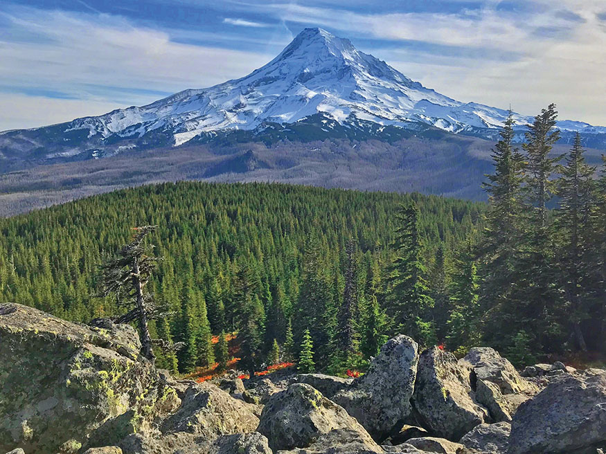
Mount Hood and the Dollar Lake Fire damage from Owl Point
THIS FAIRLY EASY trail to several flower-filled bowls at the treeline on Mount Hood is more than worth the long drive to the trailhead. Since 2011, however, it has a whole new character, as several miles of it burned intensely that summer, giving us all a rare chance to watch a forest regrow.
DESCRIPTION
The 2011 Dollar Lake Fire ravaged the north side of Mount Hood. Often, the effects of fires are overstated, but this was complete devastation. On this hike you’ll walk through the burn, and the experience is fascinating. You’ll also see how the forest is recovering. All you have to do is climb slightly for a couple of miles and you’re in (unburned) wildflower heaven.
From the trailhead, go 0.2 mile to a sign and wilderness registration at Vista Ridge Trail #626, where the burn area starts. To the left is your first hiking option, which I suggest if you don’t feel like climbing much but want a great view.
Owl Point (4 miles round-trip, 500'; full route not shown on map)
To your left is a section of trail that for years was unmaintained, becoming essentially a “lost” trail. But in 2007, dedicated volunteers from oregonhikers.org cleared 178 logs from the trail and restored this 2-mile section to Owl Point. This event was also a primary factor in the forming of a nonprofit group called Trailkeepers of Oregon. The path, now official again, is called Old Vista Ridge Trail #626A, and it offers great views and a rare opportunity for solitude on Mount Hood.
The first 0.5 mile is a bit steep, gaining 300 feet, and offers a prefire forest experience. Things then level off, and when you’ve gone 0.8 mile look for a couple of viewpoints to the right. Each reveals the alpine slopes of Mount Hood, the burned forest below that, the Clear Branch drainage, and Owl Point, which is the big rocky area on the left. Beyond it, you can see Bald Mountain in the Hood River Valley.
After reaching the top of the ridge, you’ll start back downhill and pass through a meadow. This will be wet at times and require some route-finding to keep your feet dry. Just past it, a trail leads right about 500 feet to The Rockpile, which offers an amazing view of Hood—almost as nice as the one you’re headed for.
Just 0.1 mile farther on the main trail, Old Vista Ridge Trail intersects Owl Point Trail, a 0.1-mile spur to a viewpoint named for the great horned owls that nest in the area. The path climbs briefly through forest then emerges to follow the edge of a large talus slope along a 500-foot cairn-marked route.
Off to the right as you face Hood, look for burned Vista Ridge approaching the mountain. The big hill right in front of Hood is Barrett Spur, which you can hike to. The next big open spot to the left is Elk Cove. The forested ridge off the far left is Stranahan Ridge, on which are Cloud Cap Saddle and the Cloud Cap Inn.
Be sure to sign the “summit” register, and then you might as well head back. Old Vista Ridge Trail continues another 1.2 miles past more viewpoints and on to Perry Lake (more of a pond, really), but because this involves rougher trail and another 500 feet of elevation gain, and because Owl Point is the local highlight, you could probably skip this section.
Vista Ridge Trail to Eden Park, Cairn Basin, and Wy’East Basin (4.8 miles one-way, 1,560')
Back at the wilderness kiosk, turn right and head toward Mount Hood—and into the burn. In 2012 this whole area was black trunks and ash. By 2017 it was lush with fireweed and saplings. Nature rocks. You also have views all around, which wasn’t the case before the fire. The trail gets just a bit steeper after a couple of miles, and 2.5 miles from the kiosk, you’ll arrive at Eden Park Trail. Congratulations! You’ve now climbed the biggest hill of your day, 1,200 feet—wasn’t much, was it?
Turn right toward Eden Park, and you’ll briefly plunge downhill and then start heading around to the left, crossing babbling brooks and admiring abundant flowers. After just under a mile of this, you’ll cross Ladd Creek, where logs have usually been placed to make a bridge. A quarter mile on, you’ll be in Eden Park, which might be the loveliest mountain meadow you’ve seen—so far. To preserve the fragile landscape, stay on the trails.
To continue to Cairn Basin, cross Eden Park and follow the trail through the trees as it turns toward Mount Hood. It will climb a small hill, with a view back down to Eden Park, then pass through a notch and arrive 0.2 mile ahead at campsites in Cairn Basin. Here you can turn right on Timberline Trail #600 to connect with the McNeil Point trip (Hike 36), which is just 0.3 mile and a tricky creek crossing away. Or you can go left on Timberline Trail, following a sign for Elk Cove. Doing that, at the far end of the campsites, you’ll wade or jump Ladd Creek again—this crossing might be a bit too deep and swift in the early summer—and after that it’s basically a flat mile to Wy’East Basin.
Wy’East Basin to Elk Cove (2.4 miles round-trip, 300')
When you arrive in Wy’East Basin, your car is 3 miles to your left (go 0.3 mile to Vista Ridge Trail #626, and follow it out the way you came) and Elk Cove is to your right. It’s easy and beautiful, so go for it. Just 1.2 flat miles away, Elk Cove is the most spectacular of these destinations. Here, you’ll find wildflowers throughout August, huckleberries late in the month, and reddish-orange mountain ash in October.
As you head back on Timberline Trail #600, about a quarter mile from Elk Cove, keep an eye out for a side trail leading up to Dollar Lake. It’s unsigned but follows a draw uphill in an area of short trees and a tiny stream that’s more of a wet spot in the trail. If you get back as far as Pinnacle Ridge Trail #630, you’ve missed it by about 5 minutes. Dollar Lake—so named because it’s almost perfectly round, like a silver dollar—offers nice campsites, and as you’ll see, the 2011 Dollar Lake Fire didn’t burn the area around the lake.
Barrett Spur Addition (up to 3.6 miles round-trip and 1,500')
Here’s one final challenging, off-route option. Barrett Spur is the massive ridge on the left side of Mount Hood when seen from Portland. You can get to a little over 7,000 feet on it, using a social trail that starts from Wy’East Basin. There’s nothing official about it, so all I can say is stick with it and be careful. On the way back down, look for a junction that will lead you to Dollar Lake.

GPS TRAILHEAD COORDINATES N45° 26.531' W121° 43.554'
DIRECTIONS From Portland, take US 26 to Zigzag; turn left on Lolo Pass Road. Drive 10.7 miles and take the second right at Lolo Pass, onto FR 18, signed for Lost Lake. (If you’re using Google Maps, it may tell you to go straight at the pass; don’t.) After 5.5 miles of gravel, you’ll be back on pavement, and 5 miles beyond that—having driven a total of 10.5 miles on FR 18—make a hairpin right to take the paved FR 16. (A sign here points to Vista Ridge Trail #626. You can also get to this intersection by way of Hood River; it’s longer but smoother.) Go 5.4 miles and turn right at a large intersection onto FR 1650, which quickly becomes a good gravel road. The trailhead is 3.6 miles ahead, at the end of the road. Note that twice during this stretch, you’ll need to stay left and uphill on the bigger of two roads.