47 CAPE LOOKOUT STATE PARK
DISTANCE & CONFIGURATION: 4.8-mile out-and-back to end of cape, 3.6-mile out-and-back to South Beach, 4.6-mile out-and-back to picnic area, with combinations available
DIFFICULTY: Moderate
SCENERY: Old-growth forest, high cliffs, whales
EXPOSURE: Some pretty extreme clifftop walking without rails
TRAFFIC: Moderate–heavy
TRAIL SURFACE: Gravel, dirt, mud
HIKING TIME: 3 hours to end of cape, 2.5 hours to South Beach, 3 hours to picnic area
ELEVATION CHANGE: 800' to cape, 1,000' up from day-use area, 840' to beach
SEASON: Year-round, with mud and storms in winter and spring
BEST TIME: July–September for weather, March and April for whales
BACKPACKING OPTIONS: None
DRIVING DISTANCE: 82 miles (1 hour, 45 minutes) from Pioneer Courthouse Square
ACCESS: No fees or permits required at trailhead, but parking in day-use area is $5/day.
MAPS: USGS Sand Lake; free brochure at main park area and on park website
WHEELCHAIR ACCESS: No
FACILITIES: Portable restroom at trailhead May–September; restrooms, showers, and water at campground
CONTACT: 503-842-4981, tinyurl.com/capelook
LOCATION: Cape Lookout State Park, 13000 Whiskey Creek Road, Tillamook, OR
COMMENTS: The park gets an average of 90 inches of rain annually, compared with Portland’s 37.5 inches—you’ve been warned.
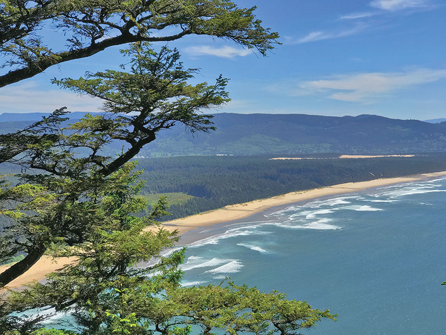
South Beach from the Cape Trail
THIS PARK OFFERS everything you’d want from the Oregon coast: old-growth forest; secluded beaches; clifftop views; and wildlife on land, wing, and water. You’ve got three options from the trailhead.
DESCRIPTION
When you park at this trailhead, you’ll have three options to choose from, and it’s all downhill from here. Of course, you’ll have to come back uphill to get to your car, but even the 800-foot climb from the beach is so well graded, you’ll hardly be winded when it’s done. (On our elevation profile for this hike, I’ve included the beach route and the cape route.)
Cape Trail
Start with the best of the three trails. Taking the trail behind the sign at the far end of the lot, continue straight when you get to a junction 100 yards ahead. After a few minutes in younger forest, you’ll be hiking through that rarest of treats: a coastal old-growth forest. Some nice Sitka spruces and hemlocks grow here, and the whole thing is as peaceful as can be. Look also for interesting forest features like a split stump, nurse logs with new trees growing on them, and widow-makers hanging over your head. This trail also manages to stay muddy in places year-round.
At 0.5 mile out, the trail dips down among some giant hemlock trees, and at 0.6 mile you’ll come to a plaque honoring the flight crew of a B-17 bomber that crashed into the cape just to the west in 1943. After another 0.5 mile, you’ll get a view north; look for the three rocks just off Cape Meares and the town of Oceanside. You can make out an arch in the middle rock—in fact, all three have such arches, and they’re called the Three Arch Rocks. I also spotted a whale below this section once. When you get to some moderately nerve-wracking drop-offs on the left, along with inspiring views south, you’re almost done.
At the tip of the cape, you’re looking 270 degrees around and 400 feet straight down at the crashing sea. There’s a protective cable at the end of the cape, but in other places you’ll be right at the top of a cliff. On a calm day—which is rare in a place that gets around 90 inches of rain per year—it’s not uncommon to see seals or sea lions below.
But the main attraction is the gray whales. Thousands of them make the trip each year from the Bering Sea in Alaska to Baja California in Mexico, a swim of some 6,000 miles. In late December and early January, when they go south, they tend to be farther out. But in March and April, they’re on their way back north with newborn calves, so they go slower and stay closer to shore. At these times of year, bring binoculars (and rain gear); you might see dozens of whales in a day. For the best viewing, go early in the day, when the sun will be behind you as you look west.
South Beach Trail
At the junction very near the parking lot, heading downhill puts you on the trail to South Beach. Avoid the temptation to take any of the various cutoff trails, as they add to erosion. If the 1.5-mile, 800-foot descent seems a little tedious (like when the beach looks as though it’s just right there below you but you’re walking more sideways than down), just know that you’ll be thankful for this easier grade on your way back up.
You can also hike down the beach, which extends 4 miles south to Sand Lake, but eventually you’ll get into an area where cars are allowed, which sort of detracts from the wilderness feeling. The tide pools are to the right.
North Trail
The last option from the trailhead is across the lot, going north on the Oregon Coast Trail. It’s 2.3 miles, all downhill, to the picnic area and the nature trail, which are by the campground. On the way, you’ll pass a couple of viewpoints, a bouncy little bridge, and some massive trees—one of which I could walk through, and I’m 6-foot-1. You will also probably have the trail largely to yourself.
If you have two cars, leave one at the upper trailhead and then start down at the day-use area. Go up and out to the cape, and maybe down to the beach as well, then end your day at the upper trailhead. Or start above and finish with a downhill—up to you, of course.
NEARBY ACTIVITIES
Take advantage of Tillamook’s tourist stops, most notably the collection of airplanes at the Tillamook Air Museum (6030 Hangar Road, Tillamook, OR; 503-842-1130; tillamookair.com). Two cheese factories are to the north. The Tillamook Cheese Factory (4175 US 101 N, Tillamook, OR; 503-815-1300; tillamook.com) is the best known; for slightly more exotic choices, as well as wine tastings and a petting zoo, visit the Blue Heron French Cheese Company (2001 Blue Heron Dr., Tillamook, OR; 503-842-8281; blueheronoregon.com).

GPS TRAILHEAD COORDINATES
Cape Trailhead N45° 20.484' W123° 58.470',
Day-Use Area N45° 21.635' W123° 58.168'
DIRECTIONS From Portland, take US 26 to OR 6; bear left, following a sign for Tillamook. Drive 51 miles to Tillamook and continue straight through the intersection with US 101. You’ll be following signs for Cape Lookout State Park and the 3 Capes Scenic Route. After crossing US 101, go two blocks and turn left on Stillwell Avenue. Drive two more blocks and turn right on Third Street. Drive 4.5 miles and turn left onto Whiskey Creek Road. After 5.2 miles, you’ll pass the state-park campground and day-use area; this is where you find the lower trailhead. The upper trailhead is 2.7 miles past the campground, on the right.