Cascade Pass © Michael Silverman/NPS
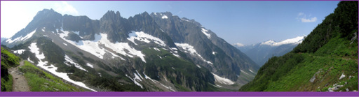
North Cascades Highway is nice, but to share a more intimate experience with the Cascades leave the car behind and set out on foot. Nearly 400 miles of hiking trails allow guests to explore the stunning beauty of the park’s river-carved valleys and glacier-capped peaks. Most trailheads are located along North Cascades Highway and in Stehekin (Lake Chelan NRA), but the true day-hiker’s paradise is Cascade River Road. It closes seasonally and after mile 10 is dirt and gravel, but should be passable by low clearance 2WD vehicles. The trails to Hidden Lake and Cascade Pass are this area’s gems and two of the best hikes in the Cascades.
Desolation Peak may not look impressive from a distance, but the views from its summit are tremendous. This peak is where Jack Kerouac found solitude working as a fire-watcher. Spellbinding scenery and isolation inspired some of his best work: Desolation Angels and Dharma Bums. To reach Desolation Peak, follow East Bank Trail from WA-20 (Milepost 138) for 16 miles to the junction for Desolation Peak. You can also reach this point via tour boat from Ross Lake Resort (206.386.4437, www.rosslakeresort.com) or your own private boat. From the junction it’s another 6.8 miles climbing 4,400 feet to the peak. See the table belowfor a more complete list of trails.
North Cascades Scenic HWY (WA-20)
Trail Name | Trailhead (# on map) | Length (Roundtrip unless noted otherwise) | Difficulty (E = Easy, M = Moderate, S = Strenuous)/Notes
Thornton Lake | Thornton Lakes Road (1) | 10.4 miles | M • Logging road leads to steep climb and classic cirque lakes
Sterling Munro | North Cascades Visitor Center (2) | 330 feet | E • Outstanding views of the Picket Range
River Loop | North Cascades Visitor Center (2) | 1.8 miles | E • Through old-growth to river and campground
To Know a Tree | New Halem Campground (3) | 0.5 mile | E • Self-guiding trail explores area’s trees and plants
Rock Shelter | New Halem Campground (3) | 0.3 mile | E • Wheelchair accessible, 1,400 year old hunting camp
Trail of the Cedars | River Loop/Linking Trails (3) | 0.3 mile | E • Self-guiding trail along river to Main Street
Ladder Creek Falls | Gorge Powerhouse (4) | 0.4 mile | E • Self-guiding trail courtesy of Seattle City Light
Stetattle Creek | Near Diablo (5) | 6.0 miles | M • Often snow-free early, requires rock scrambling
Sourdough Mountain | Near Diablo (6) | 11.1 miles | S • (1-way) Lookout (5.2 mi) with stunning glacier views
Pyramid Lake | WA-20 Milepost 126.8 (7) | 4.2 miles | M • Hike to a small deep lake created by a landslide
Diablo Lake (favorite) | North of Diablo Lake (8) | 7.6 miles | M • View glaciers and peaks from north side of Diablo Lake
Thunder Creek (favorite) | Colonial Creek Campground (9) | 23.0 miles | M • (1-way) Follows glacier-fed creek into the heart of the park
Thunder Knob | Colonial Creek Campground (10) | 3.6 miles | M • Kid-friendly hike with wonderful views of Diablo Lake
East Bank (favorite) | WA-20 Milepost 138 (11) | 31.0 miles | E • (1-way) Spur trails to Little Jack and Desolation Peak
Panther Creek | WA-20 Milepost 138 (11) | 6.5 miles | M • (1-way) To 4th of July Pass • Popular early season
Easy Pass/Fisher Creek | WA-20 Milepost 151 (US Forest Pass req’d to park) (12) | 3.5 miles/14.8 miles | S • (1-way) To Easy Pass (one of the best sites in the park)/M • (1-way) To Thunder Creek Trail
Rainy Lake/Maple Pass (favorite) | Rainy Pass on WA-20 (13) | 1.0/7.5 mi | E/M • Great hikes just outside the park, waterfalls
Bridge Creek (PCT) | WA-20 Milepost 159 (14) | 12.8 miles | E • (1-way) Follows Pacific Crest Tr to Bridge Creek Camp
Cascade River Road
Monogram Lake | Travel 7 miles south on Cascade River Rd from Marblemount (15) | 10.0 miles | S • (1-way) Climb 4,040-ft via steep forested switchbacks, and then through subalpine meadows
Hidden Lake (favorite) | End of Sibley Creek Rd (16) | 9.0 miles | M • Climb 2,900-ft on this popular day-hike to beautiful lake
Cascade Pass (favorite) | End of Cascade River Rd (17) | 3.7 miles/6.0 miles | M • (1-way) One of the best day-hikes to Cascade/(1-way) Glacier/mountain views to Sahale Arm
Stehekin (Lake Chelan)
Agnes Gorge | High Bridge (18) | 5.0 miles | E • Wildflowers early and mid-summer
Coon Lake | High Bridge/Bullion Camp (18) | 2.6 – 3.8 mi | M • Good location for birding and mountain views
Old Wagon (PCT) | High Bridge (18) | Varies | E • Pacific Crest Trail • Connects lower and upper valleys
Goode Ridge | Old Wagon Trail (18) | 10.0 miles | S • Excellent views of Stehekin River drainage
McGregor Mountain | Via Old Wagon Trail (18) | 7.7 miles | S • (1-way) Switchbacks climb to panoramic views
Buckner Orchard | Near Rainbow Falls (19) | Varies | E • Self-guiding trail where guests pick apples in fall
Rainbow Creek | Stehekin Valley Road (20) | 9.7 miles | M • (1-way) Leads to McAlester Pass/Trail
Rainbow Loop (favorite) | Stehekin Valley Road (20) | 8.8 miles | M • Popular in the early season (wildflowers)
Purple Creek (favorite) | Golden West Visitor Center (21) | 8.1 miles | S • (1-way) Explore the high country to Juanita Lake