CHAPTER 7
Rivers, Streams and Ponds
WATER SHAPED THE valley (Chapter 2) and sustains life within it. The rivers, streams, pools and mires are its surface expression. As habitats, these water bodies have always supported a concentration of biodiversity and maintained a corridor for the movement of wild plants and animals. In the past, the river has provided food, power and a means of transport (Chapter 4), but today it is used mainly for drinking water, irrigation, waste disposal and recreation.
Uniquely among the main habitats, rivers and streams express the character of, and changes in, the whole landscape. Whereas each wood or heath is self-contained to a degree, every action and event in the catchment can influence the state of the rivers. Moreover, the river is inherently a mutable entity, usually confined within its banks, but sometimes spreading out over the floodplain. The Wye not only defines and formed our region, but everything we do to the land affects the Wye.
THE WYE CATCHMENT
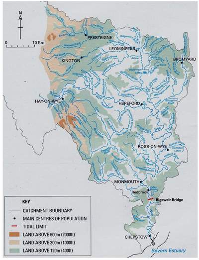
The Wye above Redbrook drains a catchment of 4,010km2 (CMP, 1994; LEAP, 1998) (Fig. 113). If we add the small catchments entering below Redbrook, the total reaches about 4,200km2. On average, some 1,087mm of rain falls each year, much of it on the Cambrian mountains at the head of the Wye. Some 478mm per year evaporates directly from vegetation, soil, buildings and water surfaces, leaving 609mm per year to soak into the ground, which amounts to the formidable total of about 2,500 million cubic metres.
FIG 113. The lower Wye catchment. The upper Wye enters at Hay-on-Wye. (Map by the Environment Agency, reproduced with permission)
Like any other major river, the Wye is the sum of several sub-catchments. Above Hay, the upper Wye is joined by the Ithon, Elan, Irfon, Edw, Llynfi and several smaller streams, whose very names show that they drain the heart of Wales, where the hill country is used mainly as pasture. Below Hereford, the middle Wye is joined by the Lugg, which drains the border country north of Hay and much of northern Herefordshire, where much of the farmland is cultivated. At Monmouth, the lower Wye is joined by the Monnow and Trothy, which drain the eastern flanks of the Black Mountains and the rolling pasture country of the southwest Herefordshire borderlands. The relative importance of each sub-catchment can be measured by its flow: of the water that flows past Redbrook, 53% comes from the Wye above Hay, 20% from the Lugg, 8% from the Monnow and 19% from minor tributaries.
The Wye is always with us, but those who live around it are all too well aware that the flow varies enormously. Measured just above the tidal limit, the mean daily flow is 73 m3 per second, but the maximum recorded flow is 905 and the least trickle is 3.4. In a dry summer the flow typically runs at 11.4 m3 per second. The tributaries differ among themselves: thus, the highest flow in the Monnow is 34 times its average, whereas the ratio for the Lugg is only 7.5. Put another way, the Lugg is a relatively peaceful, reliable watercourse, whereas the Monnow is distinctly flashy. The highs and lows of the various tributaries do not necessarily coincide, so the flow in the lower Wye is rather more even than in its various sources. Exceptionally, in August 1976, the flow at Redbrook was just 9% of the long-term average for that month, and half of that came as discharges from the Elan reservoirs.
Flooding is a regular feature of the Wye (Fig. 114). In Dixton Church, which stands on the Wye floodplain just above Monmouth, memorable floods are recorded on brass plates set into the nave wall. The 22 March 1947 flood, which
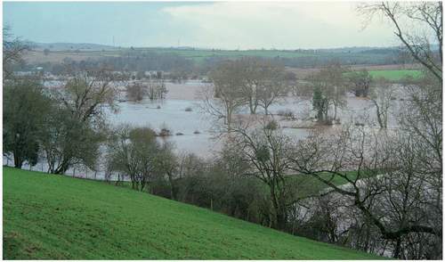
FIG 114. The Wye in flood at Sellack, December 2000.
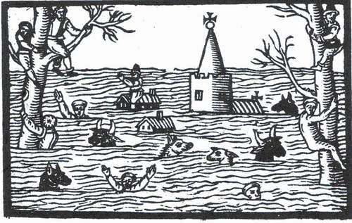
FIG 115. ‘Lamentable newes out of Monmouthshire’: a woodcut from a contemporary pamphlet showing the impact of the 1607 possible-tsunami on the Levels.
rose to 1.85m (a full fathom) above the nave floor, just exceeded floods of 10 December 1929 (1.63m) and 5 December 1960 (1.57m). Recent inundations have not been so deep, but they have been rather more frequent: 0.89m on 23 October 1998, 1.19m on 3 December 2000, and 1.24m on 8 February 2002. At Hereford, according to the Environment Agency, the October 1998 flood equalled those in 1947 and was only exceeded by those in 1795 and 1960. However, the flood on 26 November 1703 at Chepstow, when the Wye in spate met a ‘rampant [high spring] tyde’, was the most destructive, and there were other great inundations in 1768, 1799, 1846 and 1883.
None of these surpassed the disastrous inundation of 20 January 1607, when a possible tsunami (Bryant & Haslett, 2003) drowned 2,000 people around the Bristol Channel and the water lay for ten days over 26 parishes on the Levels. This, the greatest natural disaster in Britain, spread on a sunny morning, when the people did
see and percieue…huge and mighty hills of water, tumbling one ouer another…coming with great swiftness towardes them…Oxen in great numbers were carryed away with the stream, and looked like so many Whales in ye Sea (Waters, 1972).
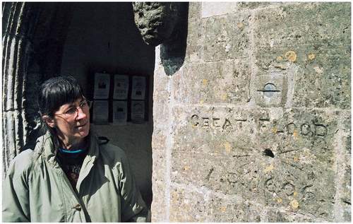
The wave travelled so fast that a lady in Llanwerne, four miles from the shore, could not climb to the upper floor of her house quickly enough. The whole terrible scene was immortalised with a woodcut in a report entitled ‘Lamentable newes out of Monmouthshire’ (Fig. 115) and recorded by marks on churches (Fig. 116). The cause is not known, but by early 2007 the principal suspects were a storm surge or an earthquake in a fault on the edge of the Continental shelf to the southwest of Ireland.
FIG 116. The high water mark recorded on the porch of St Thomas the Apostle, Redwick, after the 1607 flood. Although it might just have been possible for Susan Peterken to keep her head above water here, the leading wave of the tsunami would have been much higher. The 1606 date refers to the old calendar.
USE OF THE RIVERS
Unlike most major rivers, which were little altered until the eighteenth century, but have since been very substantially modified, the Wye and its tributaries were more obviously used in the past than they are today (Chapter 4). Long before the Middle Ages, the Wye carried a great deal of traffic, but was obstructed by numerous weirs, constructed to cultivate fish and power mills and forges (Stockinger, 1996). Small watercourses fed fish ponds, mill pools, tanneries and metal works. In 1525, for example, Tintern Abbey was using the Angiddy for fishing, corn grinding, tanning and driving a hammer. The first attempts to improve navigation with locks and towpaths came in the seventeenth century. More recently, the Wye was used to ship coal upstream from the Dean and timber, bark, grain and cider downstream as far afield as London (Eisel, 2000). Towing upstream was truly arduous, even though goods were transferred to smaller boats at Brockweir, and the boatmen’s families were parked in hovels in the Hudnalls common (the stone walls of their paddocks and tiny houses can still be seen). Until 1811, when a horse towpath was built, teams of bargemen dragged loaded boats against the current when the river was full enough, and negotiated the ‘agitation’ of the water round the boulders in the channel (Fig. 64). The decline of navigation set in soon after with the construction of a tramway from the Welsh coalfield, and was completed in 1855 with the coming of the railway, though boats still worked up to Monmouth into the twentieth century.
Navigation again became an issue recently, when a group claimed navigation rights on the basis of an early nineteenth-century Act, with the aim of installing a series of locks on the Lower Wye, thereby enabling it to be used by motorised pleasure craft and commercial traffic. However, in 2002, after a public enquiry, the Environment Agency was confirmed as the navigation authority from Bigsweir Bridge up to Hay and the public right of navigation was reasserted. Below Bigsweir, the Gloucester Harbour Trustees control navigation.
Today, the river is used mainly to abstract water and dispose of waste (LEAP, 1998). Using 1998 average figures, some 365 M1/day (365,000 m3 each day) is exported from the Elan reservoirs to Birmingham, and lesser amounts go from Monmouth to south Wales (136 Ml/day) and from Lydbrook and Redbrook to the Severn-Trent area (60 Ml/day). These exports greatly exceed the 220 M1/day abstracted for use within the catchment, of which nearly half (103 M1/day) goes into the public water supply. A further 53 M1/day is used by industry, mainly around Hereford and Leominster; 41 M1/day by fish farming, mainly in the upper Wye catchment; 13 M1/day for spray irrigation, mainly in the lowlands of the middle Wye and tributaries; and 10 M1/day for other agricultural purposes. Water is also abstracted from aquifers and springs, particularly at Sudbrook, where up to 52 M1/day is abstracted from the great spring. Water budgets need seasonal adjustment: for example, abstraction for spray irrigation occurs mostly in summer when flows are generally low, and at 39 Ml/day, with none returning to the river after use, irrigation represents almost half of the water losses from the lower catchment (CMP, 1994). Irrigation reduces any flow, but the reduction is significant to other users and the health of the river when the volume of water in the river is already low: locally it can account for 80% of losses from the Garren Brook. Fish farming has little impact, for the water returns to the river.
About half of the abstracted water returns as treated sewage effluent, principally, as one might expect, at Hereford, Ross and Monmouth. In dry weather it can account for 6% of the flow in the Wye. Until recently, crude sewage also entered the Wye at Chepstow, and in wet periods it can still overflow from sewage works elsewhere. Industrial waste has been discharged into the Allensmore Brook and Valley Brook (Coleford), but landfill sites at Chepstow, Hereford and Whitchurch have been closed and now all waste is collected and transported from the catchment.
The Wye is also used to generate hydroelectric power, particularly from the Elan catchment. A small hydropower site operates on the Pentaloe Brook at Mordiford, and plans for generating ‘green’ energy from the rapid tributaries of the gorge, such as the Angiddy, may soon be implemented. Gravel is extracted in the Lugg floodplain above Hereford.
Fishing in the Wye catchment is concentrated on salmon, trout, elvers and a variety of coarse fish. Indeed, the Wye has long been regarded as one of the premier salmon rivers in England and Wales, though present-day catches are much reduced. Elvers are caught only from the banks of the tidal reach, particularly from the grassy banks above and below Bigsweir bridge (Roger Brown, in Titcombe, 2006). There, on dark nights with an incoming tide, the banks are thronged with people with nets, some of whom make several hundred pounds in a single visit by air-freighting their catch to the Far East. Coarse fish, mainly barbel, chub, pike, roach, dace, bleak and grayling, are caught mainly in the Wye and the lower reaches of tributaries in the lower catchment. Trout occur throughout the catchment, and are fished almost everywhere except the headwaters.
Recreation on the Wye leans ‘near-to-nature’. Canoeists and white-water rafters use the upper Wye, and below Hay the river is used for canoeing, rafting (mostly gentle charity events) and rowing. Canoes mostly descend from Ross to New Weir, but some brave the renowned slalom course down the rapids below Symonds Yat and proceed to Monmouth. More seriously, rowing clubs are established at Hereford, Ross and Monmouth. Kingfisher Cruises at Symonds Yat represent a faint memory of the Wye Tour, and they glide up to Huntsham bend and return to the gorge. Below Tintern, the tidal reach is occasionally used for tranquillity-shattering water-skiing, but canoeists have realised that it is unwise to arrive at Chepstow on an ebb tide.
IMPACTS OF USAGE ON WATER QUANTITY AND QUALITY
The behaviour and biology of the Wye is modified by use and events within its catchment. Flow is reduced by water exports, but the impact is limited by releasing water from the Elan reservoirs during summer droughts. Since water continues to be abstracted at Lydbrook and Monmouth, the Wye effectively functions as a ‘pipe’ in which flows are maintained above a defined minimum, thereby avoiding the environmental damage that would result from extremely low flows. The acidity of the water entering the Lower Wye is intensified by conifer afforestation on the Cambrian Mountains, but this is being mitigated by new riparian management within plantations. Quarries may once have been polluting, but discharges from the most obvious, the Livox quarry below Tintern, are now controlled. Residential and industrial development centred in Hereford, Ross, Monmouth and Chepstow increases the rate of runoff, but there is no evidence that this has increased the incidence of floods.
However, all these influences seem trivial when compared with agriculture. As the LEAP (1998) says: ‘the processes and by-products of agriculture pose a major potential threat to the environment, especially in more intensively farmed areas.’ Besides abstraction for irrigation, land drainage (which accelerates runoff and lowers water tables), uncontrolled stock grazing (which can destabilise river banks), disposal of animal and other farming wastes, contamination of ground and surface waters by wastes, fertilisers and other agrochemicals, and accelerated soil erosion (due to ploughing on the floodplain and riverside slopes, and heavy rain falling on overstocked pastures) all damage rivers and streams. Each year some 40 consents are given for land drainage, and now much of the catchment is so efficiently drained that heavy rainfall quickly reaches the rivers and thereby increases flood risks. The major problem is the lack of a good soil management strategy that would control the loss of fine sediments and plant nutrients.
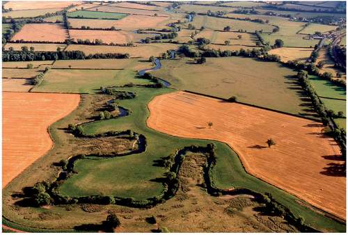
Farming and development also require floods to be controlled. Earth embankments restrict flooding at the confluence of the Monnow and Wye at Monmouth and on the lower Lugg (Fig. 117), though the Lugg Meadows are allowed to flood naturally. Woody debris is removed from the bridges on a seven- to ten-year cycle, especially at Hereford and Monmouth, to avoid any tendency to restrict flows (and damage the bridges). Otherwise, excess water spills over the floodplain. Some 155 properties are said to be at risk during ‘major floods’, of which 85 lie on the tidal reach in Chepstow, Tintern and Brockweir. Flooding in Hereford will soon be controlled by new upstream embankments and by allowing more floodwaters to spill over the Letton Lakes part of the floodplain.
From the late 1930s the Wye ‘suffered horribly from Hereford sewage’ and, as motoring increased, garages flung more and more waste oil into drains and thence the river (Gilbert, 1953). However, about 1950 Hereford built a sewage system and by 1998 water quality in 86% of the Wye catchment water quality was officially ‘very good’ or ‘good’, and only 6% was ‘poor’ (LEAP, 1998). Nevertheless, significant pollution continues. Acid deposition coming ultimately from distant industry further acidifies some of the already nutrient-poor streams draining from moorland. Effluent from sheep-dips includes organophosphates and pyrethroids that are toxic to river fauna. The major salmon spawning grounds
FIG 117. The Horseshoe at Sutton St Nicholas, where the Lugg meanders naturally between flood banks, shielded from arable by less intensively used grassland. The view looks southwards towards the Lugg Meadows. (Photo Chris Musson, © Woolhope Naturalists’ Field Club. Millennium Air Survey of Herefordshire, Hereford Record Office)
in the upper catchment are damaged by local drainage schemes, forestry, uncontrolled stock access to banks, and poor soil management. Sewage pollutes several small rivers, mostly in the upper catchment, but also the Valley Brook below Coleford. Sewage, farm effluents and runoff from fertilised fields have eutrophicated Llangorse Lake and the Llynfi, as well as the whole of the Wye below Hereford. (Eutrophication is the artificial enhancement of nutrients, especially phosphates, which over-stimulates the growth of algae and water-crowfoot, thereby clogging the channels and, when the vegetation decays, temporarily reducing oxygen levels.) Another concern is the substantial conversion of grass to arable, even on the floodplain. This not only increases the fertiliser and pesticide load in the river and spreads their impacts far beyond where they were applied, but it also accelerates topsoil erosion. Moreover, the additional silt smothers the gravelly spawning grounds of fish.
In high flows, as the lower river runs red-brown, residents in the gorge watch Hereford’s soil being washed into the Bristol Channel. Surprisingly, perhaps, this is not wholly a modern phenomenon, though the Wye was clearer than some of its tributaries. Coxe (1801) noted that the muddy Trothy discoloured ‘the purer current of the Wy’. Gilbert noted in 1928 that, after storms, the Llynfi ran ‘almost crimson and thick with the red soil which is such a feature of the landscape from here down’, and that the muddy waters of the Lugg greatly affected the Lower Wye.
RIVER STRUCTURE
The Wye and most of its tributaries still look largely natural. Nevertheless, artificial elements are legion. Embayments and shallows near Tintern and Bigsweir are the remains of moorings. Pools along the Angiddy are the remains of industry, partly modified now as fish ponds. Headwaters of the Dore were modified for water meadows. At Symonds Yat the remains of New Weir generate the rapids. In the lower Wye the broken remains of medieval weirs are still obvious at low flows.
The Lugg, Frome and middle Wye are lowland rivers, flowing through a wide floodplain in gentle meanders cut into alluvium. Bottom conditions are varied: the Lugg has clay and gravel, the Frome is largely silty and the Wye ranges from cobbles and coarse gravel to localised fine material. The Trothy, too, is generally slow-moving and lacks shallow riffles, but some of its headwaters flow steeply in narrow gulleys. The Monnow is a manifestly upland river in its upper reaches, flowing with regular rock outcrops and stony riffles between high hills in a narrow floodplain. Below Kentchurch its takes on a more lowland character, with a broader floodplain and infrequent outcrops, but the meanders have cut cliffs on the outside of the bends and deposited shoals inside. The Garren and Gamber brooks also flow in steep-sided valleys, cut into the alluvium of small floodplains, and, like the Monnow, they are lined almost throughout by alders. The Wye below Goodrich is difficult to classify: flowing in a deep gorge and looking like an upland river, it is actually bordered by a narrow floodplain into which alluvial cliffs have been cut and narrow shoals have been deposited along some banks. Its tributaries, such as the Angiddy and Whitebrook, start as lowland streams flowing gently through farmland on the plateau, but are transformed into noisy, upland cataracts as they approach the Wye.
The rivers generally form single channels with no significant lateral movement, diversified locally by shoals and small islands, and only rarely dividing into two or more channels enclosing portions of floodplain. Some islands are shoals of coarse alluvium, deposited in-channel, that have become
FIG 118. Wooded islands in the Wye below Carey Wood. This chain of three elongated shoals is entirely wooded, with mature alders in the body of the islands, and sallows on the unstable margins. Driftwood dams have built up on the leading edges. A single heron was nesting in a dead alder.
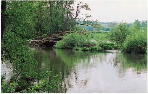
vegetated and semi-stabilised: those at Carey Wood (Fig. 118), Hole-in-the-Wall and Wilton Bridge are well wooded, mostly with crack-willow, but also with alder, ash, wych elm, sycamore and hawthorn. Point bars on the inside bends of meanders are structurally similar, but they tend to be grazed. Other islands are portions of the floodplain platform cut off by braiding, or, like the long island between Hole-in-the-Wall and Foy Bridge, only islands at low flows. The ‘Big and Little Million’ island at Hampton Meadow is bordered by permanent channels, and so too is much of Lugg Meadow, but in this case the Rhee (back channel) may be artificial. At Great Corras, below Grosmont, movement of the main Monnow channel has isolated a section of floodplain between the river and the old, now seasonal, channel. Just below Tregate Bridge, shallow outcrops and the remains of a weir form a vegetated ‘shoal’ (Fig. 119). Some islands are artificial, such as round a mill at Osbaston Weir, and the spoil dumped in the river at New Weir, both of which have become alder woods. These islands diversify habitats by creating conditions that are rarely encountered elsewhere, such as ungrazed floodplain woodland and debris-filled, semi-stagnant back channels. Finally, a radically different form of island is Chapel Rock, an outcrop of limestone at the confluence of the Severn and Wye, that keeps its head above the highest tides enough to support maritime grassland and a fragment of rose and bramble scrub.
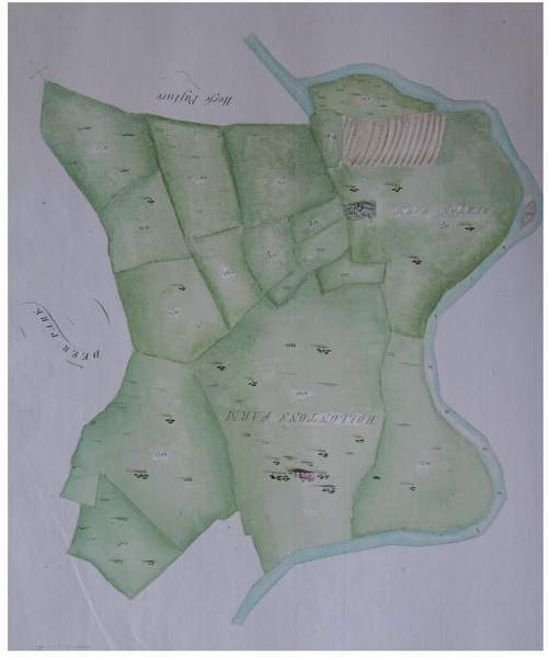
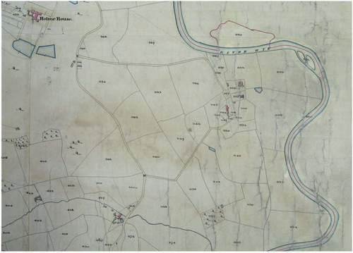
Stable though they seem, the rivers have changed in detail through the centuries. But on closer examination it turns out that in some cases what appears to be the migration of a channel is in fact an artefact of map-drawing conventions (Fig. 120). The early nineteenth-century Ordnance Survey maps show islands in the Wye at Aramstone House, Backney Common, Pencraig Court, Huntsham loop and Hadnock Court that have since vanished. The 1608 map of the Forest of Dean shows a substantial island at Lower Lydbrook that was gone by the early nineteenth century, though it is still present as a shoal that forces canoes to ground. The long, shallow depressions left by extinct channels in floodplains indicate past braiding and/or channel movement, and there is a fine oxbow lake at Letton, the ‘Horseshoe Bend’. Drainage around the lower Frome and the Worm Brook has left some parish boundaries to follow old, dry channels. At Great Corras channel movement (possibly natural) has cut off three old loops of the Monnow, leaving the parish boundary in a dry depression. In recent times there has been some unauthorised removal of shoals, and localised breakdown of banks due to trampling by cattle.
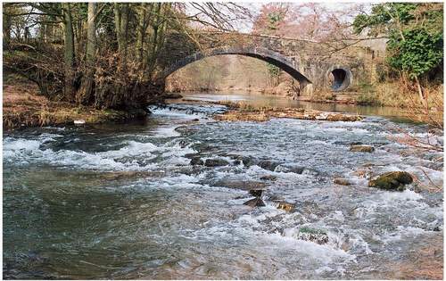
FIG 119. Tregate Bridge on the Monnow, with rapids created by a rock outcrop running diagonally across the flow. Towards the margins, vegetation has built up to form small islands.
FIG 120a. Channel movement at Holme Lacy? The estate map of 1780 (a) shows a small island to the east of the church and a field to the north that seems once to have been an island. However, the tithe map of 1840 (b) shows a different small island (split in two), and the field has apparently crossed the river. In fact, the ‘movement’ is an artefact of the 1780 map, which simply ‘consolidated’ a land holding. True movement can be seen in Fig. 2, where long, curving banks and depressions on the inside of the bend are the product of ancient channel movement. The small island has now almost merged with the adjacent field. (Based on information from David Lovelace and Heather Hurley; 1780 map reproduced by permission of Jan Scudamore)
RIVER VEGETATION
River plants range from submerged and floating aquatics to emergents that root in water but grow above it. In addition, some terrestrial species grow on shoals within the river, where they must survive both physical disturbance and regular and often prolonged inundation in high flows. Other terrestrial species occupy river banks and the floodplain, where they must be able to withstand occasional inundation. Most riparian trees grow on the banks and floodplain, but alder, poplars and some willows can also colonise and stabilise shoals. Submerged aquatics inhabit the main channel; floating aquatics and emergents grow mainly on the margins and in backwaters.
Vegetation also changes along the river. A survey carried out by D. G. Merry in 1979 (Edwards & Brooker, 1982) showed that the diversity of aquatic, riparian and bank-top vascular plants taken together was greatest in the middle Wye above Hay, whereas the diversity of bryophyte species was greatest in the upper Wye. The Herefordshire reaches, where the river flows through a broad and intensively cultivated floodplain, were the least diverse, but, as the Wye enters the gorge and comes under the influence of limestone and a greater variety of habitats, the river rejuvenates itself floristically. The Monnow probably follows the diversity profile of the upper Wye.
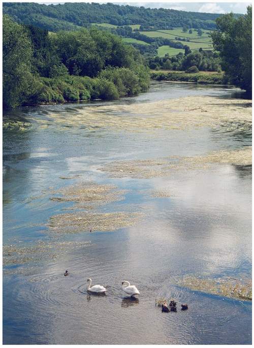
The principal aquatic in the Wye main channel is water-crowfoot, but sources differ about which species is dominant, river or stream water-crowfoot (Fig. 121). These are the white-flowered plants that can be seen waving languidly in the gentle, high-summer water. Water-crowfoot is particularly impressive below Monmouth Bridge, but it fades out at Bigsweir, where saline influences take over. Another main-channel species is spiked water-milfoil, which also has feathery submerged leaves and emergent flowers. On the margins water-pepper, amphibious bistort, water mint, branched bur-reed and reed canary-grass grow with limited amounts of shining, fennel and perfoliate pondweeds. Common duckweed is also usually confined to backwaters and margins, but during extremely low flows it will spread over the whole channel. Only two aquatic mosses, Rhynchostegium riparioides and Fontinalis antipyretica, are at all common on the Lower Wye. The Lugg, being a slower river, has a greater range of aquatics, including yellow water-lily, common club-rush, horned pondweed, blue water-speedwell and unbranched bur-reed, all of which were not recorded by Merry on the Wye.
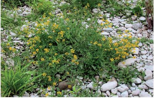
Shoals in the river form specialised open habitats, exposed through much of the growing season, but liable to inundation at any time. They are more extensive in the upper and middle Wye, but form narrowly on the inside of meanders lower down. Extensive examples on gravel at Glasbury (Fig. 122) form an open mixture of arable weeds (e.g. common poppy, pale toadflax, redshank), species of disturbed ground (mugwort, nipplewort, prickly sow-thistle), hedgerows (hemlock, tufted vetch, hogweed), marshes (common fleabane, hemlock water-dropwort, marsh woundwort), river banks (creeping yellow-cress, tansy, water forget-me-not), grasslands (knapweed, meadow buttercup) and even woodlands (columbine, common dog-violet).
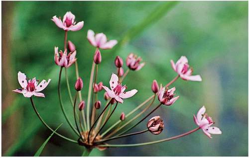
River-bank vegetation is splendidly diverse. When Woolhope Club members took a boat from Goodrich Castle to Coldwell Rocks on 27 July 1866, they recorded that tansy, purple-loosestrife, yarrow, sneezewort, meadowsweet, yellow loosestrife, common reed, water and tufted forget-me-nots, marsh yellow-cress, tufted vetch, hedge bindweed, ragged-robin, common comfrey and soapwort were the commonest tall herbs (TWNFC, 1866, pp 192-201). That icon of the river margins, the delightful flowering-rush, was – as it still is – common and well distributed (Figs 123 & 124). Purchas and Ley (1889), who may well have been in that party, also mention greater bird’s-foot-trefoil, marsh ragwort, marsh woundwort and slender tufted-sedge as common species of the Wye banks, and noted that giant bellflower, normally a woodland plant, was often seen on the
FIG 121. Water-crowfoot in the Wye below Monmouth Bridge with the resident pair of mute swans, which appear on this occasion to have reared a duck. In the background the fields above Michel Troy rise to Lydart Orles wood, one of a line of ancient woods on the upper slopes of the Trothy valley. ‘Orles’ means alders, which implies that the subsoil remains permanently moist even on these steep slopes.
FIG 122. Vegetation of shingle shoals in the Wye at Glasbury. These open herbaceous mixtures are present further downriver, but less well developed.
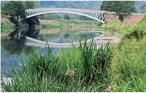
FIG 123. Flowering rush and water plantain by the Wye just upstream of Bigsweir Bridge. The aquatic and fringing plant species appear to be unaffected by the thickets of Indian balsam higher up the bank.
banks of the Wye: it still is. The vegetation was said to be less diverse where it was easily accessible to cattle.
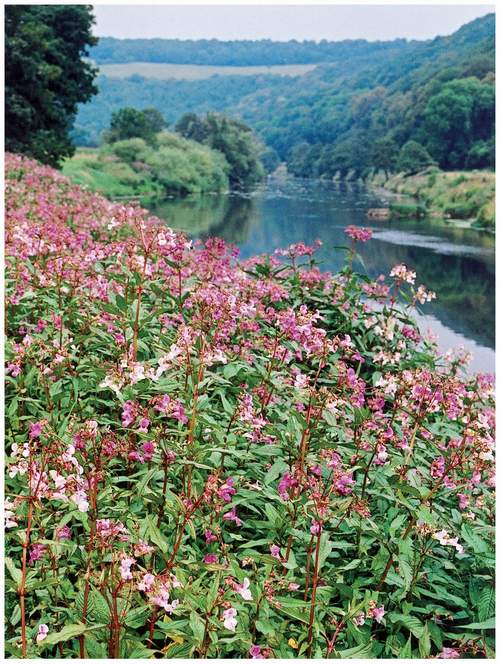
A century later, Merry’s survey found that the commonest species on the Lower Wye banks were the yellows of winter-cress, black mustard, turnip and marsh yellow-cress, the purples of common comfrey, purple-loosestrife and great willowherb, and the white of water chickweed, with species found more often on the margins of cultivation: hedge mustard, charlock, white campion, mugwort, lesser swine-cress, mignonette, tansy, shepherd’s-purse, with vigorous grasses, such as cock’s-foot, common couch and false oat-grass. Under river-bank trees they found woodland ‘weeds’, such as garlic mustard, ground-elder, creeping buttercup and white dead-nettle. The differences are not evidence of change but, independently, the Herefordshire botanists Peter and Stephanie Thomson are convinced that the diversity of Wye bank vegetation has ‘suffered horribly’ from nitrification. In particular, they see far more nettles than they did 40 years ago, and marginal emergents, such as branched bur-reed, unbranched bur-reed and common spike-rush, which were all mentioned by Purchas and Ley, may have declined. Certainly, riparian and bank vegetation has been extensively colonised by Indian balsam (Fig. 125) and Japanese knotweed, which form dense stands that exclude other species. The former has followed the classic invasion trajectory: reported from a thicket at New Weir in 1904 by Ley (1905), balsam did ‘not affect very significant lengths of the River Wye’ in the
FIG 125. Indian balsam thickets by the Wye above Bigsweir Bridge. Although the species has been present by the Wye since 1900, these colourful thickets have developed only in the last 20 years. Beyond, the woodland on the slopes occupies the two typical positions of ancient woods in and around the gorge: Wyegate Hill woods extend as far as Redbrook along the lower, steep slopes just above the floodplain, and Ferny Leaze Wood represents the end of a chain of woods that extends on the upper slopes all round the Newland meander.
1980s (Holmes, 1990), but now it is abundant and spreading up tracks into the woods.
River-bank trees (Fig. 126) are thinly scattered along the agricultural reaches in Herefordshire, and somewhat more densely clustered in the woodland and gorge reaches. Most are no more than a few decades old, which implies that the banks carry more trees now than they did. This is supported by Gilpin’s remark (2nd edition, 1789, p. 23) that ‘the chief deficiency, in point of wood, is of large trees on the edge of the river…but trees immediately on the foreground cannot be suffered in these scenes; as they would obstruct the navigation of the river.’ Old photographs and prints of bow-hauliers confirm that at least one bank was kept open until the early twentieth century to allow towpaths to function (Fig. 64).
Ash and pedunculate oak are common enough, but the most characteristic river-bank trees are alders, willows and poplars (Fig. 127). The older Floras include some unfamiliar names, but the great majority of the tree willows are white, crack-, almond and osier, with a few hybrids between themselves and between them and the sallows. Apart from the rare purple willow, they are all reckoned to be archaeophytes (Chapter 9), which implies that the original Wye floodplain woodland was entirely lacking in tree willows, a most improbable circumstance. Black-poplar is uncommon by the river, and outnumbered by
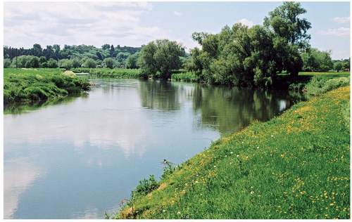
FIG 126. The Herefordshire Wye between Holme Lacy and Fownhope, bordered at this point by permanent grassland and bankside willows.
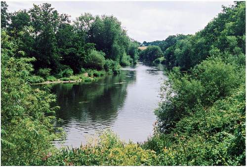
FIG 127. The Herefordshire Wye downstream of Hoarwithy in an unusually well-wooded reach. Alder, willows, sallows and ash line the banks and a narrow shingle bank has developed an open herbaceous community.
grey and white poplars, but it is reckoned to be native, whereas the latter two are regarded as neophytes. A recent search for black-poplars in Herefordshire (Watkins et al., 1997) located 147 trees, all but two of which were male. Under natural conditions, black-poplars would grow tall beside the larger rivers, but some 68% had been pollarded and most grew at some distance from a river, or off the floodplain entirely, i.e. the species has survived because it has been planted for timber and leaf-fodder.
River vegetation is constantly disturbed by floods, migrating shoals and eroding banks. It recovers rapidly, partly because the river constantly washes seeds and growing vegetation down from higher reaches, and, by this means, species that grow in the upper Wye sometimes colonise the lower Wye for a few years. Purchas and Ley (1889), for example, noticed that arrowhead, a species of the slow-moving waters of the Lugg, was occasionally washed down the Wye as far as Wilton and Pencraig, but it did not persist. In 1849, sheep’s-bit was found on the river bank near Ross, ‘no doubt a casual here; probably brought down from upland heath-grassland in higher parts of the river during floods’. Likewise, chives, which was naturally abundant on the banks of the Wye between Builth and Hay, and had never been cultivated in gardens in Herefordshire or adjacent counties, was found occasionally around Kings Caple, Ross and New Weir, ‘clearly washed down by the floods from the upper part of the river’.
VEGETATION OF SMALL STREAMS, DITCHES AND PONDS
Small streams can be particularly rich. A painstaking survey by Tim Barfield (1982) found 70-130 vascular plant species in 1km samples of streams in the Lower Wye, and a grand total of 448 species in 136 samples throughout Herefordshire, well over one-third of the county total. The detailed lists confirmed that small streams are ecologically more like linear woodlands than large rivers, especially if their banks are shaded and not grazed, for a high proportion of all species found were essentially woodland plants, even though most streams were bordered by grassland. Not only were alder, ash, hazel, hawthorn and sallows among the most frequent species encountered, but ferns (e.g. male-fern) and shade-bearing herbs, such as ground-elder, broad-leaved willowherb, cleavers, wood avens, ground-ivy, ivy, nipplewort, dog’s mercury, creeping buttercup, bramble and red campion were also common, and some 71 ‘riparian’ species were mostly associated with shaded habitats (e.g. angelica, opposite-leaved golden-saxifrage, meadowsweet, water figwort and nettle). Most were widespread, but there were also some uncommon species, such as broad-leaved helleborine, green hellebore, herb-paris and small-leaved lime. The most frequent of the 56 wetland species encountered was brooklime, followed by fool’s water-cress, water mint, water forget-me-not and water-cress, but true hydrophytes, such as yellow water-lily, broad-leaved pondweed and bulrush, were infrequent. Specialised grassland species such as common meadow-rue were found, but only rarely.
Small streams and headwaters tend, like chameleons, to take on the ‘colour’ of their surroundings. Headwaters draining the uplands not only had a distinctive set of associates, but were also the richest, for they were diversified by exposed bedrock and unaffected by cultivated farmland lower down. In the Herefordshire survey the best samples were in the Monnow headwaters. Elsewhere in the district, the small upland-type streams running in steep, wooded courses from the Trellech plateau, such as the Cat Brook, are exceptionally rich, and support several rare bryophyte species, even though they drain agricultural land on the plateau. Headwaters are also individualistic: the mini-catchments differ among themselves, and they do not ‘average out’ the wider catchment like the main river.
Ponds should also be centres of plant diversity, but huge numbers of farm ponds have been filled in during the last 50 years or so, and many of those that survive are now shaded by scrub. Herefordshire ponds were recently surveyed by Anthea Brian and Beryl Harding (1996), who found that, while most were at least partly unshaded, their water was enriched and consistently neutral or alkaline, mostly pH 6.5-7.5. This limited range of conditions usually restricted the vegetation to common duckweed, great willowherb, soft-rush, hard rush, bittersweet, water-plantain and water mint, with less frequent representation of water-starworts, common marsh-bedstraw, water forget-me-not, gipsywort, common water-crowfoot, bulrush and brooklime.
The reens of the Gwent Levels (Fig. 39) are botanically much the most important small water bodies in the Lower Wye, for they retain a rich aquatic and marginal flora, and provide refuges for some of the species of the former marshes, such as the rare liverwort Ricciocarpos natans and river water-crowfoot. In the 1960s (Wade, 1970), the commonest species of submerged aquatics were common water-starwort, Canadian waterweed and spiked water-milfoil, floating duckweeds (common, ivy-leaved and greater), and the emergents common reed, water plantain, reed canary-grass, branched bur-reed, bulrush and reed sweet-grass. A variety of other aquatics could be found, such as blunt-fruited and intermediate water-starworts, frogbit, fine-leaved water-dropwort, pondweeds
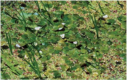
FIG 128. Frogbit in an unpolluted reen by Magor Marsh. Generally, however, reens are enriched and full of algae.
(curled, fennel and lesser), brackish water-crowfoot, arrowhead and horned pondweed. Small populations of rigid and soft hornworts, mare’s-tail, spiked water-milfoil, fan-leaved water-crowfoot and beaked tasselweed, the submerged carnivorous bladderwort and the curious hairlike pondweed added to the diversity, and water fern was first seen in 1922. On the reen margins, flowering-rush was fairly common with yellow loosestrife, purple-loosestrife, water dock and the rare marsh dock, known from Magor Marsh. Today, many reens are reduced by sewage and fertilisers to unpleasant, algae-filled ditches, but some, such as the Blackwall reen at Magor Marsh (Fig. 128), remain clean and still full of aquatics.
MARITIME HABITATS
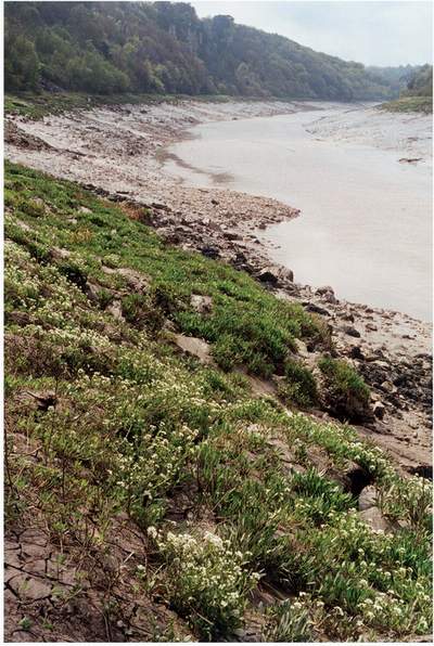
Salt-marsh species first appear on the Wye at Tintern (Fig. 129). As the muddy banks widen, sea aster, common and spur-leaved orache, common and English scurvygrass and sea club-rush become increasingly frequent, and even find themselves shaded by overhanging small-leaved lime trees, a truly strange and possibly unique juxtaposition. Sea plantain, sea-milkwort, common saltmarsh-grass and annual sea-blite appear from Lancaut downwards, and by Beachley sea arrowgrass and various glassworts have been added.
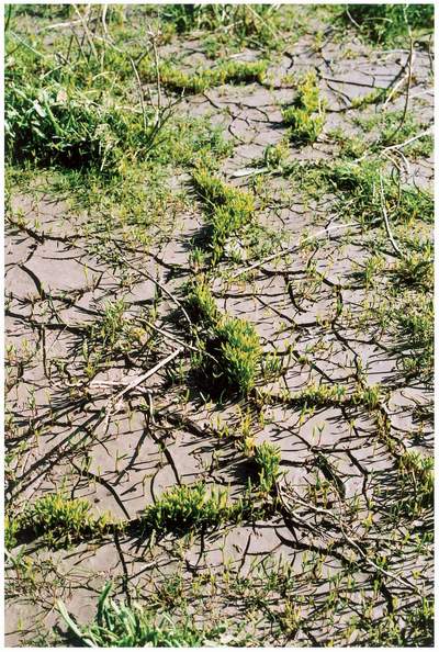
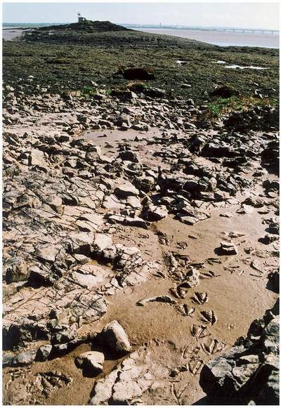
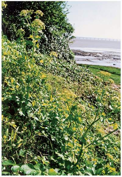
The higher-level salt marshes along both the Severn and Wye are brackish grassland used as pasture or, rarely, meadow (Chapter 6), but fragments of lower-level marsh survive along the fringes, where they are squeezed by sea walls and eroding mud banks. A distinctive common glasswort zone was once abundant at Beachley, but in the 1940s this was being invaded by common cord-grass (Riddelsdell et al., 1948). The grass has since achieved an equilibrium, leaving limited tracts of glassworts (Fig. 130), English scurvygrass and sea aster at Beachley, Black Rock, Sudbrook Point and a few other places. Deeper marine habitats are limited to the Severn. Fine beds of Ascophyllum and Fucus cover the rocks between Beachley and St Tecla’s Island (Fig. 131), and eelgrass has been recorded out in the Severn. Conversely, a few plants, such as alexanders (Fig. 132), are more abundant close to the coast, though they are not directly subjected to salt water. The biology of the Severn estuary is summarised by Dorothy Whitcomb in Titcombe (2006).
FIG 129. Scurvygrass and sea aster exposed at low tide on the banks of the Wye below Wintour’s Leap. Salt-marsh species ascend the river to Tintern.
FIG 131. St Tecla’s Island, with the remains of the hermit’s chapel, stands out in the Bristol Channel among thick beds of wrack. This is the very end of the Wye, between the two great bridges, in a world of shelducks and enormous tidal ranges.
DRAGONFLIES AND DAMSELFLIES
The most conspicuous and recognisable order of aquatic insects is the Odonata. Some 28 species have been recorded from the Lower Wye (Merritt et al., 1996) and a further two are known to be close and may be present but overlooked. Of these, the club-tailed dragonfly (Fig. 133), a June-flying black-and-yellow species with green eyes, is most closely associated with the Wye itself, where the crowfoot beds lie at the centre of its British distribution. Two other very local species, the banded demoiselle and white-legged dragonfly, are conspicuous on both the Wye and Monnow, and all three require unpolluted water with well-grown fringing vegetation. The reens on Caldicot Level support many different dragonflies and damselflies, notably hairy dragonfly, which is common, variable damselfly, emperor dragonfly and black-tailed skimmer.
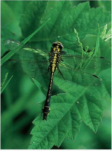
FIG 133. Club-tailed dragonfly, a characteristic species of the river Wye. (Photo: Colin Titcombe)
The Lower Wye also supports five upland associates that occur mainly in the west in bog pools, acid runnels and small, unpolluted streams, namely beautiful demoiselle, common hawker, golden-ringed dragonfly, keeled skimmer and black darter. These are on or near the edge of their range in the Lower Wye and must all have declined with the steady enclosure of commons and drainage of mires. In recent times they have been more or less confined to the Dean and the Trellech plateau. The nationally scarce white-faced dragonfly, a species of bog pools, was present in Gwent until recently according to Ian Smith, but is now extinct.
The majority of species have lowland associations: they are predominantly species of ditches, pools, slow-flowing streams and rivers, many of which are mesotrophic or eutrophic. The commonest are blue-tailed damselfly, southern hawker, common blue damselfly, large red damselfly, azure damselfly and common darter. Several, such as brown hawker and red-eyed damselfly, are right on the western edge of their range. Two nationally scarce species hang on: the downy emerald occurs only in deep lakes beside woods in the Dean, and hairy dragonfly is confined to the reens of the Gwent Levels.
The lowland species have had to adapt to historical changes in the pattern of their habitats (Merritt et al., 1996). Many must have lost ground with the draining of mires and floodplains. One, the variable damselfly, was last seen on the Gwent Levels in 1994 and appears to be the latest to lose out completely. The brown hawker was in the reens south of Magor, but is now probably extinct. On the other hand, most would have prospered with the increasing numbers of farm ponds and the construction of mill pools, and many continued to prosper in the reens and ditches that replaced marshes. In the last 60 years or so, farm ponds have been filled in, polluted or become overgrown, but the proliferation of garden ponds has provided new opportunities: in Gwent as a whole, the beneficiaries have been the broad-bodied chaser, southern hawker, blue-tailed damselfly and others. A few species, notably migrant hawker, black-tailed skimmer and ruddy darter, are expanding nationally, and this has brought them into the Lower Wye: the hawker has recently been seen at Goldcliff laying eggs (Titcombe, 2006). The ruddy darter, for example, is resident in Magor Marsh and other fields on the levels, and in some years its populations are supplemented by huge numbers of immigrants.
Invertebrates in general, and aquatic species in particular, have an impressive ability to respond to change, and this is well illustrated by the Odonata. Most gardeners will have seen how quickly dragonflies and damselflies take up territory round new ponds: according to Ray Armstrong (Wimpenny, 2000) the commonest pond-colonising species around Trellech are common hawker, southern hawker, common blue damselfly and large red damselfly. In new ponds created in woodland at Tidenham, Nigel Simpson recorded 15 species within four years – some compensation for losses, including emerald damselfly, from a pond on nearby Poors Allotment.
AQUATIC MOLLUSCS
Lower Wye water bodies contain the surprisingly large total of 24 bivalve species and 32 aquatic snails. A few are ubiquitous, but most are lowland species on or near the edge of their British ranges (Kerney, 1999). Most require clean, well-oxygenated water, but surprisingly few appear to be declining, and only four have not been recorded in the district since 1965. The reens on the levels are full of freshwater molluscs, including swan mussels, great ramshorn and pea mussel (Fowles, 1994); the last is also present in the Lawn Pool at Moccas Park. Two rare and declining species survive in the area, the fine-lined pea mussel in the Monnow, and the compressed river mussel in the Wye at Monmouth. The marsh whorl snail, said to be a species of’old wetlands’ (Willing, 1993), has been recorded in the Dean. The freshwater pearl mussel was used as food in Romano-British times – it was abundant in the detritus within Merlin’s Cave on the Doward (Kennard & Woodward, 1924) – and is still present, but declining.
OTHER MACROINVERTEBRATES
A general survey of invertebrates in the Wye was carried out by Edwards & Brooker (1982) in the 1970s. They sampled at several points along the length of the river and demonstrated that the variety of species and numbers of individuals increases with distance from source, probably because the lower reaches have greater concentrations of calcium and other dissolved solids. At sample points near Monnington, Ross, Goodrich and Monmouth, they found 166 species of macroinvertebrate. By far the most numerous in terms of individuals were Diptera larvae (true flies), especially chironomids, the non-biting midges, together with oligochaete worms, beetles, caddis larvae and stonefly nymphs. The maximum density of individuals recorded reached a formidible 22,000 individuals per square metre. Molluscs were restricted to a single species, except in the gorge, where calcium concentrations increase. Among the species recorded were several rare mayflies: these are delicate, round-winged flies with two or three long ‘tails’. Freshwater shrimp and five species of leech occurred throughout the Lower Wye.
The rivers and wetlands of the Lower Wye support many rare and local invertebrates. In particular, the Gwent Levels are reckoned to be one of the five most important grazing marshes in Britain, set apart from similar habitats in Somerset, the Norfolk Broads, the Thames Estuary and the Pevensey Levels by the profusion of hedges and willow pollards. The diversity of aquatic conditions is ensured by the variety of ditch sizes, dredging practices and cleaning regimes, which allows a full succession of habitats to be present all the time. This is important, for each combination of substrate, ditch size and stage of maintenance has its distinctive fauna. More than 100 scarce invertebrate species have been recorded, of which the rarest appear to be two nationally rare soldier flies, Odontomyia ornata and Stratiomys singularior, a small leaf miner Thrypticus tarsalis on sedges and grasses, and the big-headed fly Tomosvaryella minima. There is also a strong assemblage of water beetles, including Hydrophilus piceus, a rare coastal species, Haliplus mucronatus, and others known nowhere else in Wales, Peltodytes caesius, Hydaticus transversalis, Limnoxenus niger and Berosus affinis.
This assemblage is presumably the incomplete residue of the fauna that inhabited the marshland before it was drained. Bronze Age deposits from the Nedern valley near Caldicot (Nayling & Caseldine, 1997) were dominated by insects associated with fresh, rapidly flowing water, including many beetles with some alder-flies, caddises, bugs, dragonflies, earwigs and ants. The remains of prehistoric faunas at Goldcliff included many beetles of marsh and aquatic habitats, among which were four that implied major environmental changes (Smith et al., 2000): Oodes gracilis, now found only in warmer areas of central and southern Europe; Agelastica alni, a green species on alder leaves, which is now probably extinct in Britain, but remains common on the other side of the English Channel; Hydroporus scalesianus, now found only in a few fens, mainly in Norfolk; and Bledius occidentalis, now found in a few sandy areas on the south coast of England.
Surprisingly, the invertebrates of the lower reaches of the Wye are not well known. The dragonflies and the rare mayfly Potamanthus luteus indicate high-quality invertebrate habitat. Sedbury Marsh and the Wye banks are noted for Diptera, including several rare craneflies, such as Scleroproctapentagonalis, Tipula alpina, T. nubeculosa and T. montium. The scarce beetle Bidessus minutissimus has been recorded, and the extremely rare click beetle Synaptusfiliformis was refound at Tintern in 2003.
The Monnow, on the other hand, is known well enough to be sure that it has one of the richest aquatic and riparian faunas in Britain. In addition to the dragonflies, some 20 species of mayfly have been found, with a good range of stoneflies and caddis flies. The concentration of rare aquatic Diptera associated with sandy habitats is the richest south of the Scottish border, and among the craneflies are two species that have not been seen anywhere in Britain since they were seen on the Monnow a century ago. The sandy banks support several rare beetles, including the black and yellow click beetle, Negastrius sabulicola, the ground beetles Bembidion littorale and Amara fulva, and rove beetles Philonthus atratus, P. rutundicollis and P. rubripennis. Some eight species of riffle beetles, which live on the river bed, have been recorded, including Normandia nitens, known only from the Monnow, Wye and Teme. These all indicate high water quality.
Alan Stubbs, who initiated much of the present interest in invertebrate conservation, tells me that the richness of the Monnow from the confluence of the Honddu down to Skenfrith is due to its relatively natural condition. Emerging from the Devonian sandstone uplands onto the floodplain, the river slows down and deposits shoals of sand and stone derived from higher up. Together with islands, pools and riffles, including very stony, shallow reaches, the meanders assist the deposition of sand and shoals. Locally, floods deposit sand high on the banks, and eroding cliffs in alluvium form suitable conditions for solitary bees to nest. Habitat diversity is further enlarged by root crevices and intermittent shade formed by bankside alders. Furthermore, the Monnow’s size, situation and sediment load appears to be optimal: both larger and smaller rivers lack such diversity.
The native white-clawed crayfish was introduced from the Usk in the late eighteenth century. This is a lowland species that was widespread in the unpolluted rivers of the southern Welsh borderland and remained common in the Wye catchment in the early 1980s. Unfortunately, crayfish plague, a disease caused by a fungus to which the native species has no immunity, was introduced with the North American signal crayfish. In combination with sheep-dips, it killed large numbers of native crayfish in the 1980s (Holdich, 1991) and there is no sign of recovery.
The Lawn Pool is, or was, one of the most important habitats in Moccas Park (Harding & Wall, 2000). It held six rare beetle species, including Graphoderus cinereus, but none has been seen recently. Several scarce Diptera species associated with tufa springs, the Lawn Pool and other wetlands have been recorded, but, again, many have not been recorded recently. The pool also contains medicinal leech.
FISH
Fish have been an important resource on the Wye since prehistory (Chapter 4). They were still important to the monks of Tintern, who maintained fisheries along the Wye and Severn and employed a guardian to look after them (Williams, 2001). At Tintern Abbey, John Willifred’s gravestone was inscribed with salmon and trout: perhaps he was a fisherman. In recent times, fishermen have continued to concentrate on salmon and eels.
Some 29 species currently inhabit the Wye catchment (Edwards & Brooker, 1982). Salmon, brown trout, bullhead, stone loach, chub, dace, roach, eel, grayling, gudgeon, pike, minnow and brook lamprey are widespread, but others are localised. Flounders are found in the estuary and may penetrate upstream beyond Hereford. Carp are found in the Monnow and middle Wye, ruffe in the Monnow and Trothy, and rudd in the middle Wye. Several species breed in the river, but live much of their life at sea, notably salmon, allis shad, twaite shad, eel, river lamprey and sea lamprey. Salmon penetrate to the headwaters and shad reach up to Newbridge-on-Wye and into the Irfon, but weirs at Osbaston and Hampton Court exclude them from the Monnow and Lugg – though Duncumb (1805) was sure that few marine fish ran up the Lugg even before the weir was built. Rainbow trout are widely stocked and occasionally reach the river. Ponds contain few fish, usually three-spined stickleback (Brian & Harding, 1996).
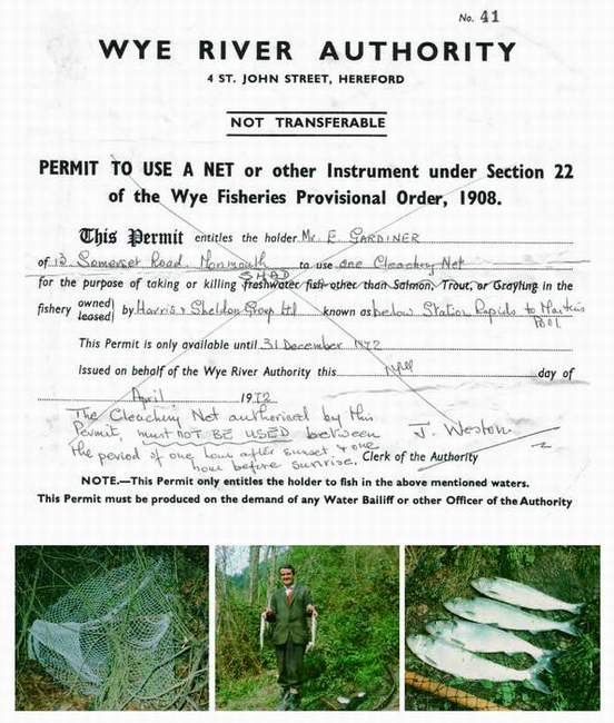
The Wye is notable for the two shads, species that, like salmon, spend their maturing years at sea (Aprahamian & Lester, 1998). Allis shad has been recorded in 26 UK rivers, with one known spawning site in the Severn, but has not been seen in the Wye since the 1940s. Twaite shad on the other hand virtually relies on the Wye. It has been recorded in 37 UK rivers, but only the Wye, Usk, Severn and Tywi have spawning populations, and the Wye has far more spawning sites (at least 25) than any other river. These sites are concentrated in the Lower Wye, mostly in the large meanders between Hereford and Ross and in the gorge down to Monmouth. Recruitment since 1990 has been fairly stable. Shad were economically important (Fig. 134): they were bought to relieve the poor during Lent, and in 1560 their price in Monmouth doubled when the Redbrook weir was built (Kissack, 1978).
The Wye was famed among fisherfolk as the premier salmon river, where the twenty-pound (9kg) fish, that would be big in other rivers, was merely average. Gilbert (1953), a lifelong riparian owner, tells of ‘the most sophisticated of men trembling with excitement, the sort of men who kill elephants and lions every winter and should be past excitement’, as they wrestled with huge fish in the
FIG 134. Ted Gardiner, the last twaite shad fisherman to use a cleach net on the Wye, his licence and his catch from the rapids at Symonds Yat. (Photos from Colin Titcombe)
famous pools of the Herefordshire Wye. Surprisingly, the fisherman with a rod, standing on the bank, wading into the river or being paddled in a small boat, is a twentieth-century phenomenon. Indeed, in 1928 Gilbert described the Wye as a new salmon river, just coming into its own. Salmon had been caught since the Mesolithic (Chapter 4) and were famous enough to rate a mention in Shakespeare’s Henry V, but by the early nineteenth century stocks were falling due to obstructions made by ironworks and illegal fishing with cribs (Duncumb, 1805), and were severely depleted by over-fishing by net in fresh and tidal waters. Before 1860, there were no controls on net fishing, so most of the fish caught were small, i.e. below 8kg. In 1861 Parliament responded to general concern by passing the Salmon Fisheries Act, but in 1874 the Wye was still the most heavily netted river in England and Wales. However, in that year the Wye Fisheries Association started a policy of buying up netting rights, and by 1909 netting was prohibited above Bigsweir. The remaining netting rights below Bigsweir were eventually purchased from the Crown in 1924, and thereafter netting was regulated.
The lowest point in the salmon population came in 1901, when netsmen gave up for lack of fish, but thereafter the recovery was steady and substantial (Gilbert, 1953; Gee & Milner, 1980). By 1928 salmon were so numerous that hundreds of spawning salmon would splash the water into foam as they crossed the fords of the upper Wye. Catches declined after 1940 as netting became a part-time occupation, but recovered as rod catching reached a peak between 1971 and 1977 at an annual average of 5,414 rod-caught fish. Thereafter, as the number of issued licences increased, so the average catch per licence decreased: in fact, the peak catch probably came close to over-fishing. Gilbert estimated that 30,000 salmon entered the Wye each year in the 1920s, but the 1980s catches left less than 1,000 salmon over 3.2kg weight to escape to spawn, and this at a time when salmon were coming under increasing pressure from fishing off Greenland.
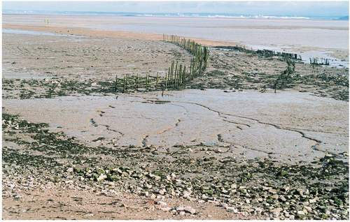
Sadly, the declared rod catch is now well below 1,000 fish (Environment Agency, 2003). The causes of the steep decline have been vigorously debated. In 1953, Gilbert recognised the ‘new enemies’ of the river as the polluters and abstractors of water, and cited in particular sewage discharges from Hereford and waste oil seeping from garages. He also blamed the netsmen of Newport for apprehending fish on their way back to the Wye. By the 1990s, however, estuarine netting, which had continued since the Mesolithic, had almost come to an end, sewage discharges were controlled, and the finger was being pointed at changes in salmon movements associated with climate change; heavy catches off southwest Ireland; acidification of the spawning tributaries draining from the hills; sheep-dip residues killing the invertebrate food of juvenile fish; over-exploitation by anglers; predation by cormorants and goosanders in the lower river; and siltation caused by agriculture. The Black Rock Lave Net Fishermen’s Association remains active to this day under the chairmanship of Bob Leonard (Monmouthshire County Life, August 2006). Otherwise, today, in order to replenish stocks, anglers are required to return fish caught before 16 June, the tuck nets can no longer be seen drifting out from St Tecla’s Chapel on the ebb tide, the stop- and lave-nets can be seen behind glass in Chepstow Museum, putcher ranks remain as abandoned, fading rows visible at low tide along the Severn (Fig. 135), and salmon boats rot by the former harbour at Gatcombe (Fig. 136).
The roller-coaster history of salmon is blamed on people, but salmon numbers may also be regulated by natural factors, or a pernicious interaction between these and furtive human activity. Gilbert records a serious outbreak of Saprolegnia ferax disease in 1883. In the late 1960s an outbreak of ulcerative dermal necrosis killed spring-running fish, the mainstay of the Wye stock. In 1976, 426 corpses were picked up in four days between Hampton Bishop and Bigsweir after a mass kill of adult salmon during the night of 28 June (Brooker et al., 1977). This disaster was blamed on drought (the previous 18 months had been the driest on record), flows reduced to less than 30% of their long-term average, endless sunshine (in the week of the kill it averaged 14.6 hours per day), hot water (water temperatures climbed to over 26 °C), and deoxygenation brought about by the decay of the massive growth of water-crowfoot (itself the product of hot weather). In effect, the fish were asphyxiated. George Woodward, a river bailiff, considers that the summer of 1976 changed everything: he saw salmon ramming themselves up the tributaries, such as the Mork Brook, to get at the cooler water, and believes that this alerted people to the possibilities of poaching, which has not since abated.
The salmon fluctuations are just one example of the constant change that takes place in the fish populations. Natural factors accelerate mortality rates temporarily, or create optimal conditions for recruitment. For example, the hot summer of 1959 encouraged chub to spawn abundantly, producing a year-class that dominated the population for years. Roach also had a strong 1959 year-class. The 1976 drought was associated with an explosion in the pike population. Long-term changes are also known. For example, barbel were first recorded in the Wye in 1970, and the eel catch has declined in recent years. Sturgeon, a prize catch before the Norman Conquest (Chapter 4), still occasionally visited the Wye in the nineteenth century (Wheatley, 1853) and were caught at Aramstone and Wyastone Leys in the late nineteenth century (Taylor, 1997), but they were very rarely seen during the twentieth century. However, one wonders whether much has changed for millennia, for the late-Mesolithic catch at Goldcliff of marine and freshwater
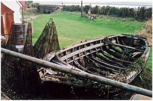
FIG 136. Abandoned salmon boat and putchers rotting at Gatcombe. The narrow, wooded Gatcombe valley has long been cut off from the Severn by the railway.
species included many eels, three-spined stickleback and other species familiar today (Bell et al., 2000).
Fishermen like to see large numbers and large individuals of species that eat well or provide good sport. On this basis, brown trout in the Monnow were said to be of poor quality in the mid nineteenth century, but the Wye was celebrated for the excellence of its perch (Wheatley, 1853). Some very large individual fish have been landed, including in 1923 the largest rod-caught salmon ever taken in Britain, a fish weighing 59.51b (27kg), caught in the Cowpond below Whitney by Miss Doreen Davey (who chose to go fishing in the Wye rather than take a holiday at Biarritz). Larger salmon, approaching 80lb (36kg), have been found belly-up. Edwards & Brooker (1982) record that pike occasionally reach the frightening dimensions of 1.1m long and 11kg, but Peter Gough knows of a 16kg pike and reports the remains of one that may have reached 27kg. In 1846 a monster sturgeon, 8.5 feet (2.6m) long and weighing 1821b (82kg), was caught at Hereford, and its much-repaired remains are still exhibited in the museum. Great fish are not just old, but also reflect human intervention and natural limitations. Gilbert was convinced that the increase in size of adult salmon was connected with the introduction of 700 salmon parr from the Rhine in 1869. When bullhead reached their highest densities in the Wye tributaries, the competition between individuals led to semi-starvation (Edwards & Brooker, 1982).
BIRDS
The rivers bring a distinctive flavour to the avifauna. Canoe parties on the Wye down from Ross will regularly be delighted by the blue flash of kingfishers. Sand martins are relatively common along the Wye and Monnow. Many cormorants and goosanders use the main river, to the consternation of salmon fishers: it still seems incongruous to see cormorants flying past the Seven Sisters rocks against a backdrop of unbroken woodland, or sitting peacefully on an island in Cannop Pond. At Piercefield, opposite Lancaut, a long-established heronry occupies the steep, mature ash-beech-oak-lime woods, and it is from here that raiders of garden ponds set out each morning. A pair of bee-eaters nested in the Wye banks near Hampton Bishop in 2005.
A detailed survey carried out by RSPB in 1977 along the entire length of the river above Monmouth recorded 129 species, of which 71 were breeding on or by the banks of the river (Edwards & Brooker, 1982). The characteristic, and usually most abundant, breeding species on the Lower Wye were sand martin, mallard, moorhen, mute swan, pied wagtail, yellow wagtail, reed bunting, sedge warbler and kingfisher. The yellow wagtail, a nationally restricted species, nested on the damp grassland of the floodplain. The kingfishers favoured fast-flowing reaches and confluences with tributaries. Many others bred in the bankside scrub and woodland, including green, great spotted and lesser spotted woodpeckers, blackcap, whitethroat, lesser whitethroat and spotted flycatcher, while curlew and lapwing bred on adjacent land. Several other species used the river, but did not nest on it, including lesser black-backed gull, black-headed gull, heron, cormorant, little grebe, pochard, goldeneye and Canada geese.
A particularly revealing comparison was made between managed and unmanaged reaches near Hay. The unmanaged reach followed a meandering course with shingle islands, riffles and high banks through rough pasture, whereas the managed reach flowed sluggishly and uniformly among arable and improved pasture, between graded banks, in a dredged bed, lacking shingle shoals. The former supported 25 breeding bird species at a density of 146 territories per 10km, but the latter supported only 11 breeding species at 43 territories per 10km. Thus, river engineering and agricultural intensification had not helped any species, but it had evidently reduced reed bunting, yellow wagtail and pied wagtail, and eliminated the once-common mallard, mute swan, moorhen, coot, sand martin, kingfisher, common sandpiper, lapwing and sedge warbler.
The riverine species found along the Monnow and other Monmouthshire parts of the Wye catchment by Tyler (2002, 2003) included a few tufted duck, goosander, common sandpiper, kingfisher, sedge warbler and reed bunting with the expected mute swans, mallard and moorhens, as well as numerous grey wagtails and dippers. Most sand martin colonies were located where meanders were eroding cliffs into the alluvium, and a few remained by the old Monnow bridge in Monmouth, where they nested in drainage pipes within the cattle-market retaining wall, now destroyed. Lapwing, curlew and yellow wagtail were still present on the floodplain, but in very small numbers.
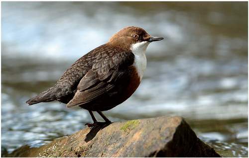
Several detailed studies on upland bird species have been undertaken in the Wye Valley, in particular Stephanie Tyler’s studies of dippers (Tyler & Ormerod, 1994) and grey wagtails (Ormerod & Tyler, 1987, 1991; Tyler & Ormerod, 1991; Tyler, 2004). Dippers (Fig. 137) are common on the upper Monnow and the steep, fast-flowing tributaries of the gorge, the Angiddy, Whitebrook and Mork Brook, where they submerge themselves to feed on the larvae of caddis flies, mayflies and stoneflies. They live mainly on upland streams at densities of up to seven pairs per 10km of stream, though the Angiddy supports eight pairs in less than 4km, including one within 3m of sea level at Tintern. Most dippers stay fairly close to home. It is the young females that move most: one intrepid brood of
FIG 137. Dipper by the Angiddy river above Tintern. (Photo by Ray Armstrong, courtesy of Grice Chapman Publishing)
three sisters from the upper Monnow dispersed variously to the Severn near Blakeney, the middle Usk, and north to the upper Wye near Erwood, distances of at least 23-44km. Grey wagtails, usually seen as long-tailed, slim, hyperactive flashes of grey and yellow, nest and hunt insects close to rivers, especially streams with riffles, lined with alder and other native trees and bordered by pasture. They are particularly numerous on the tributaries of the southern Wye catchment, where there may be up to 15 pairs per 10km of river (Ormerod & Tyler, 1994; Tyler, 2003). Since the 1980s grey wagtails have remained common, but dippers have declined by 39%, due perhaps to a combination of pesticides, increased silt loads, and the increasing ‘spatiness’ of the river (resulting from accelerated drainage from farms around the headwaters), all of which affect the numbers of aquatic invertebrates or the ability of the birds to see prey (Tyler, 2004). However, in the last two years Stephanie Tyler has noticed a slight recovery.
The recent decline in dippers and the spread inland of cormorants and gulls exemplify the constant change of riverine bird populations. Southall (1884) long ago reckoned that they were ‘ruled by the severity of our winters’, but they seemed to be increasing when he was writing, because there were fewer barges with wildfowling bargees once the railway had opened. At that time, the river still had small flocks of brent and white-fronted geese, some shelduck, many mallard and a few of other ducks. Cormorant, gannet, great crested grebe, red-necked grebe, goosander and red-throated diver had evidently declined, but were still present. Dippers remained common on the Garron. All terns, gulls and petrels were vagrants, driven in by ‘the American gales’.
MAMMALS
Like fish and birds, mammals illustrate the complicated interactions between people and wildlife. Consider, first, the fate of the three species that are closely associated with the river. Beaver, otter and water vole were the native riverine species present, but beaver became extinct before the twelfth century, otters vanished from the Lower Wye in the mid twentieth century and water voles were exterminated in the 1990s. The blame lay not with persecution, except perhaps in the case of the beaver, but with habitat change, pollution and the depredations of the introduced mink.
Otters and water voles must have been common and widespread in the Wye catchment before the twentieth century, and certainly the Wye was traditionally an otter river (Edwards & Brooker, 1982). Otters were hunted in the eighteenth and nineteenth centuries, but numbers decreased so much in the 1950s and 1960s that in 1957 the Wye otter hounds ceased to meet, though otters were still present from Hay upwards in the late 1970s. The decline was due not to hunting but to pesticides. Mink took their place: this American import was established in the catchment by 1968, initially in the middle Wye between Hereford and Ross, and was into the Monnow and Trothy by the mid-1970s, becoming essentially ubiquitous by the end of the decade.
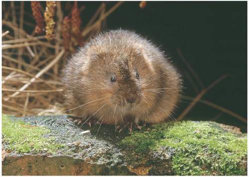
Although nobody seems to have noticed until the late 1980s (Strachan & Jefferies, 1993), the spread of the mink had a devastating effect on the water voles (Fig. 138). These small rodents burrow into river banks just above the water line, and thrive where bankside and emergent vegetation is long and luxuriant, supplying both food and seclusion. Mink, however, can extract voles from their burrows, reinforcng the damaging impacts on voles of both heavy grazing and engineering works that accelerated the water flow. By 1990, water voles were thinly scattered through the catchment, remaining common only in the upper Wye tributaries, and the distribution of mink tellingly complemented that of the voles. By 1997 water voles were confined to the upper tributaries (Jefferies, 2003), finally dying out in the main river because surviving sub-populations were too small and far apart to be viable. Today, the Wye and adjacent catchments have developed into a great hole in the national distribution of water voles, though Dan Owen found signs of a small population in the Rudhall Brook near Lea in
2005, and Derek Upton told me that water voles survive on the ranges on the Caldicot Level, where the warden looks after them.
Fortunately, the otter staged an impressive return through the 1980s and 1990s, helped by pesticide regulation and publicity for habitat management. By the early 1990s there was a resident population between Ross and Monmouth and above Hereford, and today they are again ubiquitous, save for the smallest headwaters (Hulme, 1996; Crawford, 2003). This should eventually be good news for the voles, for otters are more aggressive than minks and are too large to catch voles in their burrows. Thus far, the mink have declined, but the voles have not spread, though their prospects are improving. By 2006, the River Monnow Project had fenced 64km of river bank and coppiced the alders, allowing marginal and in-stream vegetation to recover, and brown trout to increase. More hopefully, the Game Conservancy Trust and others released some 350 voles into the Dore in 2006, after mink had been trapped-out, and this reintroduction seems to be going well.
For completeness, it is worth noting that the cetaceans that come ashore in Gwent include common dolphin, sei whale, minke whale and fin whale (Titcombe, 2006); and that common seals occasionally chase fish shoals up the Wye.
HOW NATURAL IS THE WYE?
The Wye is regarded as the most natural major river in southern Britain, but how natural is it really? A natural river would not be reduced by abstractions, nor augmented by discharges. The channels would not be embanked or dredged, and flooding would be allowed across the whole floodplain. Surrounding land and the floodplain would be covered with natural vegetation, most of it woodland. Deadwood and other debris would accumulate in the channel, redirect the flows, and thereby diversify the channel structure and cause channels to migrate across the floodplain as they erode the banks on one side while building shoals on the other. This movement would leave oxbow lakes and seasonally dry overflow channels on the floodplain. The migrating channel would braid into two or more streams at several points. And a natural river would also be free of species introduced by people, directly or indirectly.
Judged by these exacting standards, the Wye is far from pristine. It has been used, modified and controlled for millennia. Vegetation in the catchment has long been modified by farming, and this has allowed soils to be eroded from surrounding land and deposited on the floodplain. Woodland has long since been removed from the floodplain, and direct contact between the river and ancient woods has been minimised, though not as severely as it has around most lowland rivers. Dead wood falls into the channel from riverside trees, but it is regularly removed. The river is bridged and almost the whole length is a property boundary, so there have long been strong incentives to minimise channel migration. Some limited braiding remains on the lower Lugg, and the Wye contains a few small islands, but the channel is mostly simple, and oxbows and overflow channels remain largely as shallow depressions in fields. Bankside vegetation, which is controlled by adjacent land use, has proved to be open to invasion by introduced plants, notably Indian balsam and Japanese knotweed. Unlike in the past, much of the floodplain is ploughed. The banks have been artificially stabilised in a few places. The numerous croys, or fishing jetties, modify the channel and destabilise the banks nearby. The river has been dredged: in 1934, for example, 43,000 cubic metres of rock, gravel and silt was removed from between Monmouth and Bigsweir (Stockinger, 1996).
The other forms of modification are far less visible. Water quality is judged to be very good, but this is a judgement based on utilisation. From the wildlife perspective the quality has been much reduced over the last 20 years, due to enhanced quantities of silt entering from the increasing number of ploughed fields on and near the floodplain, and enhanced phosphate levels resulting from sewage and fertilisers. Water abstraction from the Elan reservoirs reduces the amount of water in the river and modifies the frequency and severity of floods. When the river is topped up at low flows in order to continue abstraction lower down, a pulse of cold water is released that administers a cold shock to summer wildlife.
The Wye appears to be natural partly because it is not obviously used. Fish weirs, trows and industry have vanished. With the towpaths out of use, bankside trees have grown up. The channel has not been straightened or canalised: indeed, it has escaped much of the engineering and controls that have made other rivers so conspicuously artificial. Importantly, it is still allowed to flood, so development on the floodplain is limited. Unlike most major rivers, it has no upstream conurbations, nor a city across its mouth, and much of the farmland is pasture, so the water is regarded as clean. Unlike many Welsh rivers, its water has not been polluted by effluent from mines. Moreover, surrounding landforms are wild and dramatic, and the catchment is largely rural and ‘natural’.
If the Wye really were still wholly natural it would be far less visible among the floodplain woodland and would probably look far less coherent than the sharply defined river we see today. It would often split into several channels, bordered by long pools and marshes on the floodplain, and would more often be in flood. Has its departure from its natural state diminished its wildlife? Are salmon, for example, more abundant than they would be naturally because debris dams no longer block access to headwaters, or less abundant because fallen wood in the channel no longer diversifies channel structure and injects organic matter into the food chain? We cannot be sure. Perhaps the best conclusion is that the Wye is aesthetically natural, but ecologically it is only as natural as modern life allows.
Can it stay as natural as it is? Cooke (1913) described how Sedbury House once contained ‘a large drawing of…the great barrage projected for the Severn in the earlier half of last century. It was to reach from Beachley to the cliffs of Aust upon the river’s further shore, and would have made its stream, now so attenuated at low tide, a brimming basin in which ships would ride with ease at any hour of the day or night.’ A Severn barrage is again being vigorously promoted. Depending on its form, it would slow the outflow of the tides, reduce the exposure of the tidal mudflats, reduce the feeding grounds for estuarine birds, impede the movement of migratory fish and, rather sadly, eliminate those rare astonishments when seals stare from the water at Tintern Abbey.
