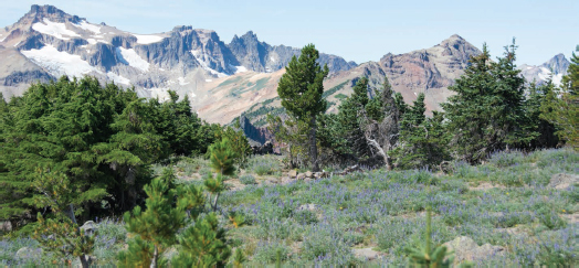
Tieton Peak closer in the middle with Gilbert Peak above the Conrad and Meade Glaciers to the left and Ives Peak above McCall Glacier to the right, all from lavender meadows.
BEAR CREEK MOUNTAIN |
ELEVATION: 7337 ft, with 1317 ft vertical gain
DISTANCE: 3½ mi up, 7 mi round-trip
DURATION: 1½–2 hours up, 3–4 hours round-trip
DIFFICULTY: Mix of moderate for the standard route (solid trail, rocky, dusty, steeper last mile, drop-offs near top, wildlife sightings possible including marmot, deer, elk, coyote, black bear, and mountain goats) and very challenging for lollipop loop down N ridge (Class 3, bushwhack, very steep, sharp branches and brush at times, scrambling)
TRIP REPORT: Best side door to the Goat Rocks Wilderness for the easiest summit with the best views without having to hike several miles before it gets good! The only downside is the longer drive from Seattle or Portland. No fee or restroom.
TRAILHEAD: Section 3 Lake TH. Take I-5 S from Seattle to exit 154A for I-405 N (Renton) to exit 4, merge onto WA-169 S to Enumclaw, turn left onto WA-410 E/Roosevelt Ave into WA-123 S, turn left on US-12 E 15 mi to White Pass, then 9 mi more to milepost 158½, turn right on paved Tieton Reservoir Road (FR-1200, signed for Clear Creek Recreation Area) 5 mi easily and quickly winding around Clear Lake. Turn right on gravel Cold Creek Road (FR-1205, signed for Section 3 Lake) more than 2½ mi, turn left on FR-742 for ¼ mi, turn right on FR-1204 (correct signage, follow signs and arrows when in question) 3½ mi, fork right to the end at the circle (roughest road section: narrow, rocky, few pullouts, 2WD okay but high-clearance AWD recommended). From Portland, take I-5 N to exit 68 (Morton/Yakima), turn right on US-12 E 90 mi, turn right on Tieton Road and follow like above (130 mi, 3 hours from Seattle; 180 mi, 3½ hours from Portland).

Tieton Peak closer in the middle with Gilbert Peak above the Conrad and Meade Glaciers to the left and Ives Peak above McCall Glacier to the right, all from lavender meadows.
ROUTE: Walk by the kiosk and old sign for Bear Creek Mountain on Trail 1130 (rutted at times) past Section 3 Lake (more a small tarn pond) immediately, then easily traverse SW and S below the E side of the main ridge. Move through a few smaller pines and then across tiny creeks and open meadows where you can see Bear Creek Mountain ahead. At more than 2½ mi from the TH arrive at a juncture where you stay right (WSW) at the sign posted to an old tree stump on Trail 1130A. The trail will be rockier, dustier, and steeper before and after the intersection as you ascend the wide, rocky gully to the high ridge. Encounter a micro-break in the pitch and then it’s steep again with wildflowers mixing in for the remainder.
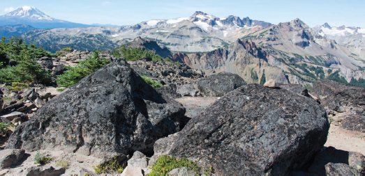
See Mount Adams and nearby Gilbert Peak from the high ridge. Walk a bit easier up the wide trail with thinning pines to the highest open and narrower ridge section where Mount Rainier pops into view for the final 100 ft along with the entire main ridge of the Goat Rocks Wilderness, including Gilbert Peak, Ives Peak, Old Snowy Mountain, Hawkeye Point, and Johnson Peak! And along the ridge continuing SW from Bear Creek Mountain to the main ridge is the serrated Devil’s Horn up to Tieton Peak (pronounced TIE-it-tun peek). Far to the N, Mount Stuart and the Alpine Lakes Wilderness can also be spotted on a clear day from the boulders on top. Return the same way for the simplest descent to the TH.
There is one other option for the descent. Although shorter than the main trail at less than 1½ mi (and about an hour down, which is the only direction recommended), the ridge N then NE back to the meadows from the summit is more trying than it appears—with some drop-offs—but not without its charm and allure to press on as you keep the amazing vistas a while longer. About a hundred yards N from the top, hike left without trouble around black rock, then scramble briefly nearest the ridgeline with a bit of loose rock.
Next, stay on or barely right (E) of the crest to miss some brush (although missing all of it may prove difficult). Continue to bushwhack, with no trail, to meet the ridge at a wide saddle. Following the saddle is a small bump you must climb; be careful to avoid the sheer rock wall to the left. Stay in the center of the ridge for a time, then right again easier. The route becomes narrower and tree-covered in spots to a small saddle before the last little bump (above 6800 ft) with sharp black rock surrounding it.
Down climb around 100 ft steeply to the right (E) from the saddle, through loose rock, leaving the ridge and large pylon; then traverse NE through scree above a boulder-filled meadow back to the wider ridgeline again with some grasses and a few trees. There is one more brief scramble, down workable rock on the ridgeline, before you traverse right of the crest again by old snags and tree roots. It’s somewhat rough just as you see the main trail below in the nearby larger meadow to the right. Work down to it slowly to finish the loop and turn left (NE) to the TH on Trail 1130.

Absolutely glorious look past the highest peaks within the Goat Rocks Wilderness to Mount Adams from the boulder-strewn summit of Bear Creek Mountain.