DOME ROCK |
ELEVATION: 4859 ft, with 3260 ft vertical gain
DISTANCE: 5 mi up, 10 mi round-trip
DURATION: Around 3 hours up, 5–6 hours round-trip
DIFFICULTY: Strenuous. Steady steep and even steeper at times, narrow, switchbacks, overgrown at times, rocky near top, drop-offs
TRIP REPORT: Opposite the bustling Detroit Lake State Recreation Area is this wonderful workout to outstanding views of the lake and Mount Jefferson up Tumble Ridge with a superb payoff from the treeless peak! Dome Rock is the highest summit close to Detroit Lake and the second highest summit in a rather picturesque little cirque surrounding Tumble Lake. The hike to the very top is more difficult in winter with snowshoes but tempts locals, as the first couple miles usually remain snow-free. No fee or restrooms.
TRAILHEAD: Tumble Ridge TH. Take I-5 S from Portland to exit 253 in Salem, turn left for OR-22 E (Detroit Lake/Bend) 46 mi, and turn left into the sleepy, small pullout immediately after crossing over the bridge signed for Tumble Creek (just W of milepost 48; 95 mi, 1¾ hours from Portland).
ROUTE: Left of the sign warning about algae blooms in the creek and lake is the sign for Tumble Ridge Trail 3380, Dome Rock Trail 3381, and Tumble Lake Trail 3379. Walk past the old green gate N along Tumble Creek as the overgrown old FR-105 road is easy less than ½ mi to a fork. Hike to the right (NE) on Trail 3380 steeper up the apparent narrow trail clogged with salal and Oregon grape. After 5 switchbacks and turns through the old forest of Douglas fir, vine maple, hemlock, and cedar, see Detroit Lake and Mount Jefferson (¾ mi up).

Traverse ½ mi NE on a friendlier grade as the route is a bit overgrown through the thick woods to another switchback. Notice the burn areas above and below the trail. In ¼ mi more, turn right (N) up the ridge past additional burned trees. Ascend 2 switchbacks (USGS maps off here) with views opening past rhododendron steadily steeper. Hike NW up 2 more switchbacks before the trail eases some on a high traverse at 2 mi from the TH. See Detroit Lake and radio towers across the valley on the lowest part of Hall Ridge, which comprises the W side of the cirque around Tumble Lake to Dome Rock.
Trail 3380 becomes steeper again as you cross a tiny creek (that dries up) to a switchback at less than 3 mi up. Climb the wide ridge N up 2 turns where it’s somewhat overgrown into a clearing, then move back into the woods to an old road junction. An aged wooden sign denotes that OR-22 is 4½ mi away, but it’s really a little more than 3¼ mi from the intersection to the TH. Walk right 25 ft, then left (NW) at the tree blockage up the continuation of the solid Trail 3380.
Travel up 2 quick switchbacks, then follow the steeper, rockier, narrow ridge trail. You see rhododendron, bear grass, paintbrush, and Mount Jefferson on a traverse E and N of a bump before the trail finally mellows and evens descends a few feet on the ridgeline. Walk up some more, and then at 4 mi from the TH leave the high ridge on a traverse left (S) of Dome Rock with a quick shot left to Needle Rock along the way.
In ¼ mi, hike a few feet down very steeply crossing a rocky, boulder-filled area, then climb up past little cliffs on the right under Dome Rock. Be mindful as the path is narrow and overgrown. You see back to Detroit Lake, Mount Washington, and Three Sisters. Then it’s super-easy through the trees to the juncture with Dome Rock Trail 3381 on the right (newer sign embedded into a tree next to an old sign at 4½ mi from the TH).

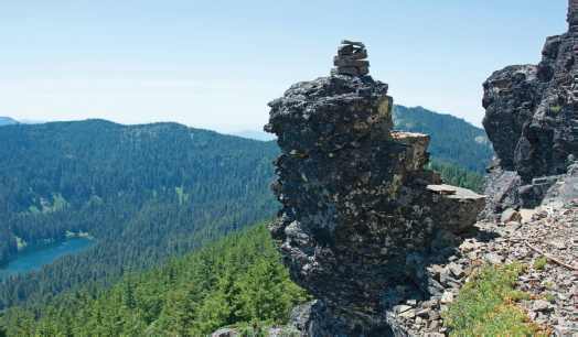
Above the woodland down to Tumble Lake.
Turn right on Trail 3381 nearly ½ mi to the summit. For this, walk up to a nearby saddle on the ridge crest and turn right (E) at a switchback. Continue much steeper through the woods with less flora and some views from the rockier path down to Tumble Lake right (E) of Elephant Rock. Comically S of Tumble Lake is Tumble Rock with Tumble Falls on Tumble Creek, accessible from Tumble Lake Trail and/or Tumble Ridge Trail down very steeply E of Tumble Lake! Finish the summit block instead up 5 quick switchbacks as you suddenly break out into the wide open above tree line to an old cement lookout foundation slab surrounded by broken glass.
You will find plenty of nice picnic perches along the wide-enough summit plateau with wildflowers and a nice breeze to cool off and keep the flying bugs at bay. To the N you’ve got Bull of the Woods Wilderness, N of the nearby French Creek valley. The tip of Mount Hood can be seen to the NE just left of Battle Ax Mountain. To the E are Olallie Butte and Mount Jefferson. Farther SE is Three Fingered Jack just left of Coffin Mountain, with Mount Washington, and Three Sisters. Marys Peak on the coast can be seen as well.
Locally we have the radio towers up Hall Ridge to Whitman Rock, Water Tower Mountain, and Sardine Mountain. Dome Rock down Tumble Ridge completes the cirque above Tumble Lake. If you walk a few more steps NW to the end of the summit you see the Forest Service road moving past the upper TH to Dome Rock. The winding, dusty, longer drive cheats you out of almost all of the hiking, shortening it to only 1½ mi each way with very little elevation gain. Return the same way.