A line of bright, red triangles, dramatically annotated “Ring of Fire,” lies immediately above the Aleutian Islands in one of the National Geographic Society’s maps of the Pacific Ocean. The symbols announce that the earth is restless along this seam where the North American and Pacific tectonic plates meet, a work in progress. The eternal, grinding collision of these plates ensures that the Aleutians experience frequent earthquakes, hundreds in an average month. Most are barely detectable, but several temblors in the last century were rated on the Richter scale as 8 and above, each as powerful as the 1906 quake that devastated San Francisco.
Even the earth’s magnetic field seems to be still under construction here. Aeronautical charts of the area are sprinkled with cautions about large magnetic disturbances over short distances, making conventional “wet” compasses unreliable guides to direction. The caution for Kagalaska in the central Aleutians, one mile east of Adak Island across a narrow strait, is typical of these warnings. “Magnetic disturbance of as much as 11° exists at ground level near the northwest end of Kagalaska Island,” it announces in bold magenta type.
Extremes of topography and weather assemble naturally in this region, too. The eponymous Aleutian Trench lies just south of the islands. At its deepest point, the waters of the trench go down 4,200 fathoms, almost 4.8 miles, putting it among the great submarine canyons of the world. The shallow Bering Sea, north of the archipelago, with its notorious rogue waves and dense ice fogs as opaque as milk, has been a famous killing ground for fishing ships for three centuries.
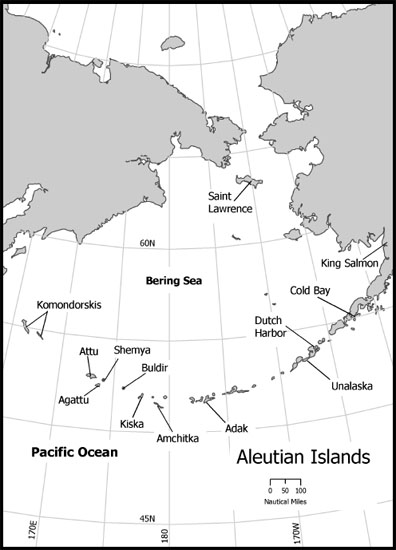
The Aleutian Islands and the Bering Sea
Two circular ocean currents bracket the islands north and south, slowly churning unimaginable quantities of cold salt water past the Aleutians in counterclockwise loops, or “gyres.” On an oceanic scale, these gyres on both sides of the Aleutian chain are relatively small; nevertheless, they influence the rich marine life of the region and help shape its dramatic weather.
The Aleutians appear to have been first settled by native peoples moving to the islands from east to west, backfilled about eight thousand years ago, perhaps three millennia after the Bering land bridge that once connected Asia to North America was submerged beneath rising waters. (“Land bridge” erroneously suggests a fragile connection. In reality, the “bridge” was one thousand miles across.) The retrograde pattern of settlement suggests that the inhospitable, treeless islands—the peaks of submarine volcanoes once the ice cap withdrew and the ocean rose—were no one’s first choice as a domicile, judged inferior even to the bleak Arctic Ocean shore that still sustains the Eskimo of mainland Alaska and the Inuit of Canada.1
The second Kamchatka Expedition of Discovery, led by Vitus Bering, a Danish-born, Russian navy officer, opened the Aleutians after 1740 to Russian hunters and trappers. It also brought catastrophe to the islands’ native peoples, whom the Russians named “Aleuts.”
There were not many Aleuts (they called themselves “Unangan”) when the Russians came, perhaps never more than twenty-five thousand, wresting a difficult life in small dug-out hovels, hunting the mammals of the sea and fishing its waters from high-prowed baidarkas, rugged oceangoing canoes. Mean conditions on the islands for their human residents were offset by the Aleutians’ generosity to their other fauna. The region once teemed with seals and sea otters, but these animals unwittingly committed the error of being worth more dead than alive. The sea otters’ beautiful coats (the sleek beasts had no layer of fat to keep them warm and relied entirely on their thick fur for insulation in cold water) made them especially precious.
Lured to the islands by the descriptions of Bering’s naturalist, Georg Steller, the first of the promysloviki (Russian trappers and skinners), reached Attu, western-most of the Aleutians, in late 1745. Thousands of valuable skins were taken from the islands each year after that (more than 350,000 sealskins alone in one record season; the annual average was perhaps one-fifth of that) until the populations of these animals nearly collapsed under the weight of predation. By 1820, even the sea otters offshore the small Russian settlement on the central California coast were almost gone.2
Under somewhat similar pressures, the Aleut population crashed, too. In 1845, one Russian missionary estimated there were fewer than twenty-five hundred Aleuts alive; one hundred years later, a new estimate put the number at about fourteen hundred. Battles against Russians, slavery, servitude, disease (smallpox, tuberculosis, and the flu epidemic of 1808–9), famine, and alcoholism had taken away the rest. In two short centuries of contact with outsiders, the Aleuts had been very nearly driven to extinction.3
The Russian thrust across the North Pacific behind Vitus Bering (and Alexi Chirikov, his principal subordinate) was slender, but it had a long reach. Southbound Russians would eventually brush up—gently, their occasional meetings appear to have been wary but cordial—near today’s San Francisco against northbound Spaniards, who were busily planting missions up the California coast to strengthen their own territorial claims and control over natives. But in time there would be little evidence left of the Russian presence on the Pacific Coast of North America: the occasional exotic structure (the onion-domed, Russian Orthodox Church at Ninilchik, Alaska, for example, or the restored Fort Ross on the California coast north of Bodega Bay); a few place names (the Russian River and Sebastopol, named after the Crimean seaport, in Sonoma County, California); and the gene pool of Alaska’s native peoples.
The purchase of Alaska by the United States in 1867 substituted neglect for abuse, a condition which persisted until mid-1942. That is when the islanders were hastily relocated to the Alaskan mainland after the Japanese attacked Dutch Harbor on Unalaska Island as part of their Operation MI, a powerful, two-pronged trans-Pacific thrust.4 In the north, the bombing of Dutch Harbor and Japanese amphibious landings on Attu and Kiska triggered a harsh and meaningless campaign in the Aleutians remembered as the “thousand mile war,” one that cost many lives but had no influence on the larger conflict.
Operation MI’s much more important southern offensive, on cornflower-blue seas in the mid-Pacific, ended in flaming disaster for the Imperial Japanese Navy (IJN). On 4 June 1942, in the most decisive battle involving Americans since Gettysburg, two U.S. Navy task forces sent four Japanese aircraft carriers and their air wings to the bottom northwest of tiny Midway Island. The successful ambush was possible only because cryptanalysts squirreled away at Station Hypo, in the basement of Pacific Fleet headquarters, knew Admiral Yamamoto’s plans. They had been reading the IJN’s encrypted radio transmissions. The lopsided loss—it cost the Americans only two ships, the carrier USS Yorktown and the destroyer USS Hammann—sank Japan’s offensive ambitions at sea. For the rest of the war, the IJN played defense with growing desperation.
Three years later, immediately after World War II, the last of the Aleutian expatriates were allowed to return to their barren home islands. The returnees were resettled in half a dozen sites. No one settled on Adak Island, near the center of the chain. Instead, during the next forty years the U.S. Navy developed the northeast corner of Adak as an important base for cold war submarine surveillance and radio signals intelligence collection. The rest of the island remained uninhabited.