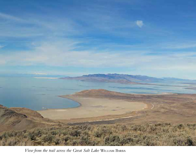
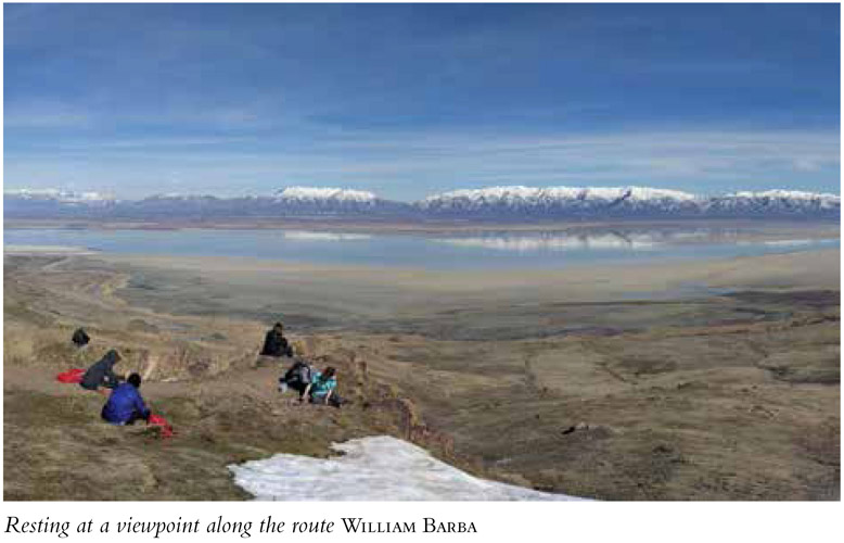
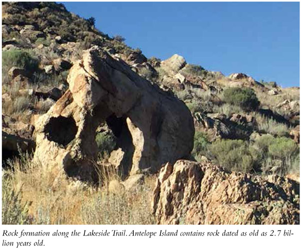
Frary Peak is the highest point on Antelope Island—a thoroughly original state park that sits in the Great Salt Lake (second saltiest body of water in the world) west of Salt Lake City. The trail rises quickly and is unfettered by trees, so the views around the island and across the lake stretch before you from the beginning of the hike. The hike runs through sparse grass and sage on this desert island as well as fascinating rock that dates back 2.7 billion years. The views across the island and the Great Salt Lake, along with wildlife such as bison, antelope, and deer, propel this highest-peak notch to a must-do status. From the summit you get 360-degree views that open the entire island, even the southern section, where public access is limited. The trail offers very little shade, so hiking in the morning or evening will provide the most comfortable temperatures. Take plenty of water.
Start: Frary Peak trailhead on Antelope Island
Distance: 6.6 miles out and back
Hiking time: About 5 hours
Difficulty: Strenuous
Elevation gain: 2,100 feet
Trail surface: Dirt and rock path
Best season: Spring and fall
Other trail users: None. Horses are allowed all over the island, but it is unlikely you will find them on this trail.
Canine compatibility: Allowed on leash
Land status: State park
Nearest town: Syracuse
Fees and permits: Fee required to enter the state park gate, payable at the causeway.
Schedule: Antelope Island is open year round. Hours vary by season: During the summer the island is open from 6 a.m. to 10 p.m.; Nov through Mar the island is open from 6 a.m. to 6 p.m. The Antelope Island State Park Visitor Center, located on the north end of the island, is open year-round and offers restrooms, water, and exhibits and a video presentation to help you learn more about the island. The visitor center is open 9 a.m. to 6 p.m. Apr 15 through Sept 14; 9 a.m. to 5 p.m. Sept 15 through Apr 14.
Maps: USGS Antelope Island, Antelope Island North
Trail contacts: Antelope Island State Park, 4528 West 1700 South, Syracuse 84075; http://stateparks.utah.gov/parks/antelope-island. Entrance to the island: (801) 773-2941; Visitor Center (801) 725-9263; Utah State Parks and Recreation, 1594 West North Temple, Ste. 116, Salt Lake City 84116, (801) 538-7220, http://stateparks.utah.gov
Special considerations: Timing is crucial at Antelope Island. If you don’t want to be barraged by the smell of rotting brine fly pupae, overrun by swarms of the annoying but harmless mature flies, or end up during the biting gnat hatch, it may be a good idea to check the website for updates. It’s best to avoid this hike in July and August. This trail is closed for a month or more in spring during the bighorn sheep lambing season. Verify accessibility by calling (801) 725-9263.
Finding the trailhead: From Salt Lake City take I-15 north to Antelope Drive (exit 332) near Layton. Turn left (west) off the exit onto Antelope Drive. The road connects directly to the causeway on the far west side. There is a parking lot before the fee booth if you wish to carpool; otherwise each vehicle must pay the entry fee to cross the causeway. When you get to the island, head left along the east side of the island toward Fielding Garr Ranch. The Frary Peak trailhead is 5 miles down this road; watch for signs. You will turn right onto a dirt road and travel to an upper level of the island for the trailhead. The trail leaves from the south side of the trailhead; take the upper trail to the right. GPS: N40 59621' / W112 12.153'
The Hike
Frary Peak Trail is a hiking-only trail with the best views and photography opportunities on the island. Located on an island in the middle of the desert, this trail provides an escape into a unique ecosystem. Though the beach looks like any other, only algae, brine flies, and brine shrimp can withstand the high mineral levels in the water. However, these three life forms thrive here. In fact, the Great Salt Lake is the world’s largest provider of brine shrimp. The brine shrimp and brine flies feast on the algae, while birds enjoy both the flies and the shrimp.
The lake and its islands are a crucial stopover point for millions of migrating waterfowl. Nearly 80 percent of Utah’s wetlands surround the Great Salt Lake, making it one of the most important migratory points in North America. The area hosts 250 bird species each year. Birders can enjoy the largest lake west of the Mississippi and all the birds that use it as a crucial point on their life paths. The Great Salt Lake is a remnant of Lake Bonneville, a prehistoric freshwater lake that was ten times larger than the Great Salt Lake during the last ice age. The current lake size fluctuates with runoff but is about 75 miles long and 28 miles wide. The lake is typically three to five times saltier than the world’s oceans.
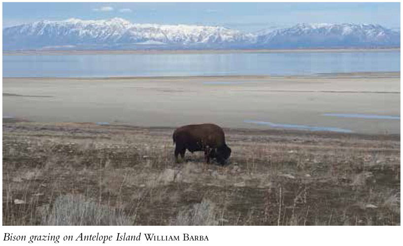
The Frary Peak Trail affords a view across the island that often provides glimpses of the herds of bison. The top of Frary Peak is the only vantage point from which the entire island, including the south side, can be viewed.
The trailhead is a big gravel lot with plenty of parking and looks out over the Great Salt Lake. Two trails head out from the south side. Take the upper trail to the right, which quickly begins to climb the desert mountain. Views immediately open to the east over the lake. The trail is rimmed with grass and sagebrush, so the views open wide across the island. The trail is also interspersed with interesting rock, and you find the first as you start your climb.
Artifacts on Antelope Island reveal more than 6,000 years of human habitation. Native Americans showed Jim Bridger the island in 1824, and John C. Fremont and Kit Carson made the first Anglo exploration of the island in 1845. They named the island after watching the abundant antelope graze the grasslands. Today the island hosts a managed herd of 500 bison. Each fall a giant roundup pulls horses and riders from all over the United States to bring in the herd for counting and maintenance. The island is also home to nearly 200 pronghorn antelope, 350 deer, and 160 bighorn sheep.
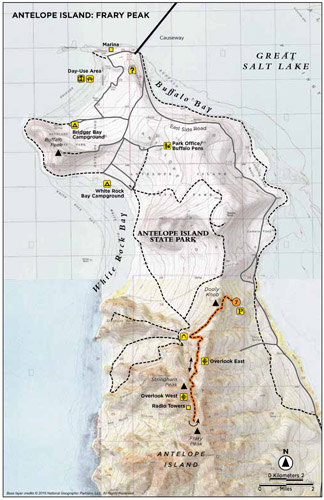
The trail forks at Dooly Knob junction. The right fork heads to the other side of the island. Follow the left fork as it continues straight (south). The trail climbs to the top ridge of the island and then drops down onto the west side, with views over the other side of the island and the lake to the west.
At 1.3 miles the trail passes under a set of boulders that create a shaded cave. The trail then continues to the right and then circles above the rocks to begin a set of steep switchbacks before an open climb through the grasses to get back up to the ridge of the island.
Atop the next ridge is a nice rock outcropping and lookout point to the south and east. From here the easy-to-follow trail again cuts around over the west side of the island and heads south. The southern two-thirds of the island contain some of the oldest rock found anywhere in North America. The Farmington Canyon Complex dates back 2.7 billion years, older than rocks found at the bottom of the Grand Canyon.
At 2.7 miles you reach another overlook ridge that affords interesting views down into White Rock Bay to the west. From this point you can also see to the east, with the Wasatch Front in full view.
A set of radio towers sit on top of the island. You’ll reach these at 2.8 miles, and from here Frary Peak is only a short 0.5-mile climb to the south. Two trails leave the area south of the radio towers. The left (east) trail proceeds toward Frary Peak over the rocky cliff outcroppings you see before you. The right (west) trail drops back down 150 feet under the cliffs and then climbs back up to the peak. Choose the rocky route only if you’re surefooted, unafraid of heights, and ready to climb over rocks using both hands and feet. If you choose the lower route, be prepared to lose elevation and then have to regain it to climb back out. There are nice views no matter which route you take.
Utah’s 84,916 square miles make it the eleventh largest state in the United States.
Frary Peak is marked with a stack of rocks and a summit marker disk secured into the rock. The peak is a flat landing reached by climbing up and over the rocky surroundings, reaching the summit at 3.3 miles. The 360-degree views around the entire island, the Great Salt Lake, surrounding islands, the Wasatch Front, and the mountain ranges to the west are worth the climb. Forty miles to the southwest, Deseret Peak—highest peak in the Stansbury Range—is visible. Take some time to enjoy the fruits of your labor before retracing your steps.
Miles and Directions
0.0 Start at the Frary Peak trailhead.
0.8 Come to the Dooly Knob trail junction; take the left fork and continue straight.
1.3 The trail comes to a shaded rock cave.
1.6 Arrive at a southeast-looking viewpoint.
2.7 Arrive at the White Rock Bay overlook. There is an eastern view of the Wasatch Front as well.
2.8 Reach the radio towers.
3.3 Arrive at Frary Peak. Return the way you came.
6.6 Arrive back at the trailhead.
Hike Information
Local events and attractions: Great Salt Lake Bird Festival; www.greatsaltlakebirdfest.com. The Antelope Island State Park Visitor Center is open year-round. Located on the north end of the island, the visitor center offers restrooms, water, and exhibits and a video presentation to help you learn more about the island. Visit https://stateparks.utah.gov/parks/antelope-island/ for more information on the state park. Fielding Garr Ranch (801-510-7056) is accessible year-round on the southeast side of the island. Tours are available for those who want to explore the island’s pioneer history, and horseback adventures depart from the ranch. The Antelope Island Marina at the north end of the island provides boat slips.
Camping: Primitive campgrounds are available on the island in addition to day-use picnic areas near the shores of the Great Salt Lake, where many like to take a dip in the salty waters that increase buoyancy. White Rock Bay group campground and Bridger Bay Campground provide picnic tables, fire pits, and vault toilets but no water or electricity. Reserve America handles all campsite reservations: (801) 322-3770.
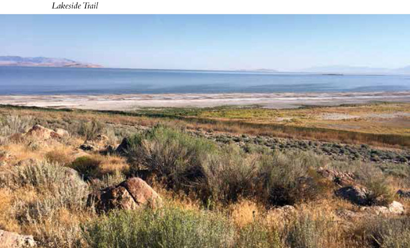
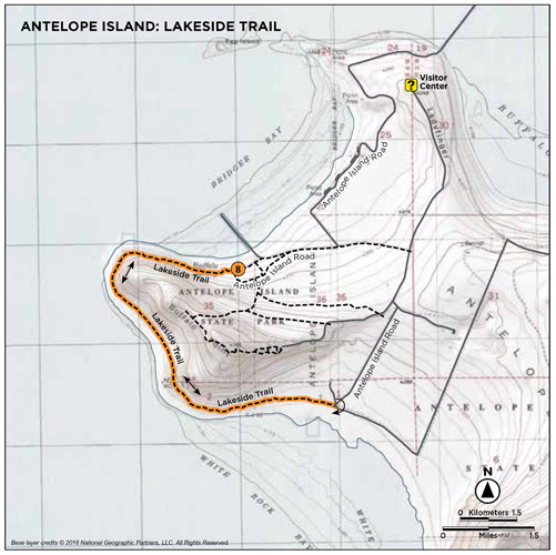
Lakeside Trail is one of my favorite trails on Antelope Island because the trail is a scenic meander around the northwest tip of the island, and the route affords you views of the Great Salt Lake through the entire hike. The elevation gain is minimal, and bison often wander on the latter section of the trail. It’s a trifecta of scenery, easy strolling, and wildlife. Antelope Island is a desert landscape, but the lake is a sapphire shining in the desert sun. Balm for the desert soul, the view of the lake is certainly the highlight sparkling and stretching out across the west desert. Antelope Island is home to the pronghorn antelope, which contributes to the exotic feel that makes the island seem like a remote getaway, while still being so close to millions of people just across the causeway. A trip to Antelope Island is a trip to another world, a unique ecosystem with high-salinity water that allows nothing but brine shrimp to survive. I recommend taking time to go to the visitor center to truly comprehend the wonder of this salty haven.
Start: West end of Bridger Bay campground; Lakeside Trail trailhead
Distance: 5.6 miles out and back
Hiking time: About 3 hours
Difficulty:Easy
Elevation gain: 154 feet
Trail surface: Gravel and packed dirt
Best season: The trail is usable year-round, but the hot days of July and August are not ideal times as the desert sun and exposed southern aspect of the trail can prove less pleasant. The trail is open and pleasant in the winter, though snowshoes or extra traction may be needed at times.
Other trail users: Horses, bikers
Canine compatibility: Leashed dogs permitted
Land status: State park
Nearest town: Syracuse
Fees and permits: Fee to enter Antelope Island State Park
Schedule: Antelope Island is open year-round. During the summer the island is accessible from 6 a.m. to 10 p.m.; Nov to Mar from 6 a.m. to 6 p.m.
Maps: USGS Antelope Island, Antelope Island North
Trail contacts: Antelope Island State Park, 4528 West 1700 South, Syracuse 84075; (801) 725-9263; http://stateparks.utah.gov/parks/antelope-island
Special considerations: The water of the Great Salt Lake is not potable. The high levels of salinity do not allow for drinking, so bring plenty of water. Remember that bison are wild and loose on the island, so only bring dogs you can control and who will not excite the wildlife. Late May or early June there is a biting gnat hatch. Check the websites for updates on the hatch.
Finding the trailhead: From Salt Lake City head north on I-15 to Antelope Drive, exit 332 in Layton. Turn left off the exit onto Antelope Drive (UT 108). Head straight west on this road for just over 6.5 miles where you will run into the fee booth that marks the entrance onto the causeway and Antelope Island State Park. There is a parking lot just before the fee booth for groups who may want to carpool onto the island. Cross the causeway, a 7-mile stretch to reach the island. At the island the road comes to a V split. Take the road to the left. At 1.1 miles from the V turn right. Follow this road straight into Bridger Bay Campground. Follow it through the campground to the far west side. You will come to the Lakeside Trail trailhead which is marked by a sign. Six parking spots are available in front of the sign. GPS: N41.03971' / W11.226314'
The Hike
This easy, pleasant trail begins at Bridger Bay Campground and curves around the northwestern tip of the island to White Rock Bay, meandering beneath Buffalo Point as it sweeps along the curve of the island, always looking out over the blue waters of the Great Salt Lake. Sage and rocks line the first section of the trail, the Bridger Bay area. At 0.8 mile the trail makes its way around the point. Once you turn the corner beneath Buffalo Point, the trail becomes grassy and open. This section of the trail is more exposed and open to the sun and wind. If you see bison on the trail, they will usually be in this area of White Rock Bay. Bison have been on the island for more than 100 years. Every year the bison are rounded up for veterinary checks, shots, and sale. About 150 are auctioned each year to control the size of the herd. There are between 500 and 700 bison on the island. From this south side you can see the highest point on the island, Frary Peak to the southeast, as well as more southern sections of the island. The trail makes a straight path along the island for another 2 miles where it ends at a circle turn-about that is marked by another Lakeside Trail sign. If a restroom is needed, head left out of the circle, up the gravel road, for a quarter of a mile to a pit toilet. Turn around and follow the trail back to the parking area.
Miles and Directions
0.0 Start at the Lakeside Trail trailhead.
0.8 Trail rounds the corner of the island beneath Buffalo Point into White Rock Bay area.
2.8 Arrive at the other end of the Lakeside Trail. Return the way you came.
5.6 Arrive back at the Lakeside trailhead and parking area you started from.
John C. Fremont and Kit Carson made the first known Anglo exploration of Antelope Island in 1845. The island was named after the pronghorn antelope the explorers observed grazing across the island.
Hike Information
Local events/attractions: Great Salt Lake Bird Festival, www.greatsaltlakebirdfest.com.
The Antelope Island State Park Visitor Center is open year-round. Located on the north end of the island, the visitor center offers restrooms, water, and exhibits and a video presentation to help you learn more about the island. Visit https://stateparks.utah.gov/parks/antelope-island/ for more information.
Fielding Garr Ranch (801-510-7056) is accessible year-round on the southeast side of the island. Tours are available for those who want to explore the island’s pioneer history, and horseback adventures depart from the ranch.
The Antelope Island Marina at the north end of the island provides boat slips and a place to launch watercraft.
Camping: Primitive campgrounds are available on the island in addition to dayuse picnic areas near the shores of the Great Salt Lake, where many like to take a dip in the salty waters that increase buoyancy. White Rock Bay group campground and Bridger Bay Campground provide picnic tables, fire pits, and vault toilets but no water or electricity. All camping reservations are handled by Reserve America at (801) 322-3770.
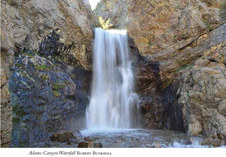
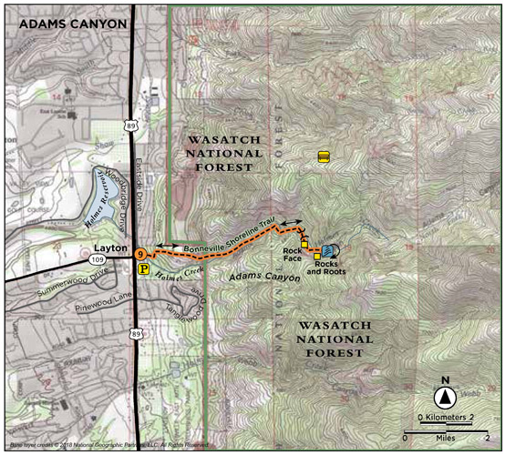
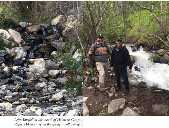
It’s safe to say that Adams Canyon is Davis County’s most popular trail due to accessibility and the 40-foot waterfall at the end of the canyon. Adams Canyon was named for Elias Adams, an early pioneer, but today the trail is much more developed than it was in his day. The hike begins on a sandy, sun-exposed climb where barriers have been built to keep the trail from dissolving down the hillside. Once in the canyon, the trail is shaded and runs next to the north fork of Holmes Creek. You enjoy the sights, sounds, and coolness of the stream as you climb your way to the fresh and impressive waterfall at the top.
Start: Northeast corner of the parking lot
Distance: 4.0 miles out and back
Hiking time: About 2 hours
Difficulty: Moderate
Elevation gain: 1,247 feet
Trail surface: Dirt, stone, some rock scrambling, stream crossing
Best season: Summer and fall
Other trail users: None
Canine compatibility: Dogs permitted
Land status: Uinta-Wasatch-Cache National Forest
Nearest town: Layton
Fees and permits: No fees or permits required
Maps: USGS Kaysville
Trail contacts: Salt Lake Ranger District, 6944 South 3000 East, Salt Lake City 84121
Special considerations: In places the trail requires scrambling across rock faces and steep root inclines and may not be suitable for the less than fit. Watch for rattlesnakes.
Finding the trailhead: From Salt Lake City head north on I-15 to exit 324 near the Lagoon Amusement Park. Head south on US 89 toward South Ogden for 6 miles. Take your first right on a small road after the Oak Hills Drive stoplight and then another quick right onto a frontage road. The trailhead is 0.25 mile down this road. Parking is plentiful, but no water or restrooms are available at the trailhead. GPS: N41 03.980' / W111 54.565'
The Hike
Once within the canyon itself, the hike provides shade and pleasant traveling, but the first 0.5 mile—from the trailhead up to the Bonneville Shoreline Trail—is a sandy slog that climbs over 500 feet of switchbacks to line you up for entry into the canyon. At the top of this section you hit the Bonneville Shoreline Trail (BST), a trail that marks the old shoreline of prehistoric Lake Bonneville. From the BST you gain a viewpoint out across the valley below. Views open up of Antelope Island, the Oquirrh Mountains on the west side of the valley, and the Wasatch Front.
Head right along the BST and continue straight into the canyon when the trail continues to the south. The trail then winds into Adams Canyon and drops into a shaded singletrack that follows the north fork of Holmes Creek through scrub oak and white pine. The well-defined trail is easy to follow, with the first creek crossing coming 1.6 miles into the hike. A bridge makes crossing easy, but once on the other side you quickly enter the last phase of the hike and the most difficult maneuvering over rock faces and a less-defined trail. Stick closer to the creek when you have the option rather than getting caught up in the talus and side trails up the right side of the mountain.
There are places along this last portion of the trail where you may wonder if you have hit the end of the trail, but keep going. You’ll know the end—the waterfall is hard to miss. The trail and the creek curve to the left just before the waterfall, and here you must cross the stream. Plan to get your feet a little wet, as the crossing is shallow but 20 feet wide. Once you cross the creek and turn the corner, the waterfall appears out of nowhere. This is a perfect spot for a snack or lunch and a dip in the falls before heading back to the trailhead.
Miles and Directions
0.0 Start at Adams Canyon trailhead.
0.5 Hit the Bonneville Shoreline Trail; head right and continue straight into the canyon.
1.6 Come to a bridge crossing.
1.7 Reach a rock face that requires scrambling over or hiking up and over the top of the rock.
1.8 Come to a jumble of rocks and roots that must be scrambled up and over.
1.9 The trail appears to run into a talus slope. Follow the trail along the creek, or in the creekbed, to the waterfall that lies just around the corner.
2.0 Reach the waterfall. Return the way you came.
4.0 Arrive back at the trailhead.
Hike Information
Local information: Davis County Convention and Visitors Bureau, 1572 North Woodland Park Dr., Ste. 510, Layton 84041; (888) 777-9771; e-mail: info@davis.travel
Camping: There are a few fire rings in this canyon that indicate past campsites. Camping is permitted at these sites. No fee or registration required.
Holbrook Canyon begins and ends with cascading waterfalls, while the middle is more of the same. A wet hike, the trek up the canyon follows Holbrook Creek deep into the Sessions Mountains. The riparian area is lush with foliage, swampy sections, creek crossings, and the sound of the creek. Prepare for a long day, a steady grade, and wet feet, but you will also enjoy the shade of a deep canyon hike and the sound of Holbrook Creek the entire way. This trail is long, and bushwhacking is often the order of the day as you get deeper into the canyon. This trail has lots of burrs that can torment your canine friends, and it should only be attempted by older children who are hearty hikers. Shaded in many places, the hike up Holbrook Canyon can be a wonderful hike in summer and fall. Its proximity to local neighborhoods make it a hike that many people access intending to enjoy smaller sections of the trail, rather than topping out of Holbrook Canyon. The river crossings and groves along the way provide picnic space and stopping points for enjoying the stream.
Start: Holbrook Canyon/Sessions Mountain trailhead
Distance: 9.4 miles out and back
Hiking time: About 7 hours
Difficulty: Strenuous
Elevation gain: 2,233 feet
Trail surface: Doubletrack dirt road, singletrack packed dirt, bridges, stream crossings, marshy areas
Best season: Summer and fall
Other trail users: Horses
Canine compatibility: Dogs permitted
Land status: Uinta-Wasatch-Cache National Forest
Nearest town: Bountiful
Fees and permits: No fees or permits required
Maps: USGS Fort Douglas
Trail contacts: Bountiful City maintains the trailhead: Bountiful Parks Department, (801) 298-6178.
Special considerations: Hiking poles will be helpful during the many stream crossings, as will sturdy hiking sandals or hiking shoes you don’t mind getting wet. Throw in the bug repellent as well.
Finding the trailhead: From Salt Lake City head north on I-15. Take the Bountiful 2600 South exit 315 and head east. Follow the road as it winds around to 1800 South and turn right (east). Continue through Bountiful to Bountiful Boulevard on the far east side of the city. Turn left onto Bountiful Boulevard and continue 0.8 mile to the trailhead, which sits off to the right. The paved parking area is just across the street and slightly south of the LDS Bountiful temple. There are restrooms at the trailhead. GPS: N40 52.902' / W111 50.662'
The Hike
A quick descent from the parking area down a doubletrack gravel road puts you immediately at the mouth of Holbrook Canyon. A waterfall meets you at the mouth as the trail heads east into the canyon. From your first steps into the canyon, the trail parallels Holbrook Creek and you are immediately immersed in a forested, riparian world. During spring runoff the creek will be higher and water crossings deeper, during early summer the foliage is thick and often encroaches on the trail in all its green glory, and in autumn the canyon is a patchwork of fall colors. At the higher elevations, the snow takes awhile to melt out; although you may be able to access the lower portions of the trail in late spring, you will not be able to make it to the top until later in the summer.
Within the first 0.5 mile the trail makes two quick forks. The second junction runs into the stream. Head to your left, slightly upstream, where the trail continues to a small bridge crossing. There are numerous stream crossings over the next 1.0 mile. Some are on established footbridges; others require rock hopping or cooling your feet in the water.
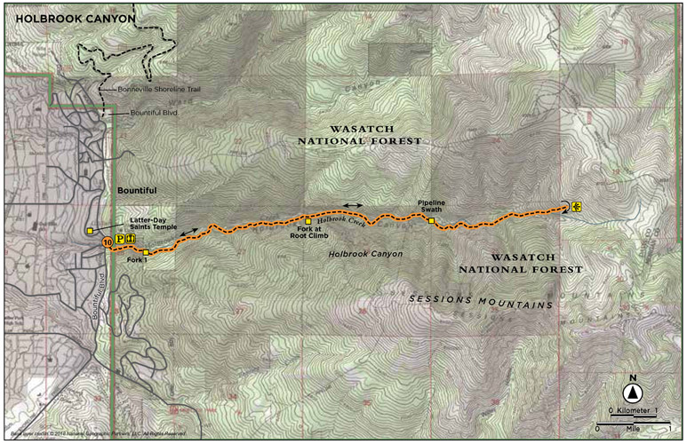
At 2.0 miles the trail runs into the stream. You must walk upstream a few yards to get back to the trail, which climbs up the mountain on a steep root bank. You can either follow that route and drop down again later or head right, cross the stream, and catch the trail up the canyon on the other side of the stream. If you climb up the root bank, a trail continues to a rock, where the trail disappears. At this point you would need to climb down below the rocks to hook up with the trail below, next to the stream. This is the halfway point and often used as a turnaround point.
This last section of the trail is traveled less and more overgrown. The footpath stays visible, but the foliage closes in more quickly around the trail. Be prepared for swampy areas and times of following stream rivulet trails as you proceed up the canyon.
At 3.3 miles a large natural gas pipeline, brought from Wyoming, crosses through this area of the Sessions Mountains on its way to California. The pipeline was cut through this trail in 2011; the hiking trail continues upcanyon on the other side of the cleared swath.
The climb out of Holbrook Canyon to the viewpoint is short and sustained. At 4.5 miles the climb up and out begins. The trail ends 0.2 mile later at a flat stopping point that allows you to look down Holbrook Canyon with views of the creek cascading down to the north and all the way downcanyon for a view of the Great Salt Lake, Antelope Island, and the city of Bountiful. Enjoy the view, and then return the way you came.
Note: The Forest Service requests that users are careful not to create extra side trails in the area.
Bountiful Trails Committee, Bountiful City, and the Forest Service are currently working on development of the Bountiful Shoreline Trail that will intersect with Holbrook Creek Trail in the near future.
Miles and Directions
0.0 Start at the Holbrook Canyon/Sessions Mountain trailhead.
0.4 The trail forks; follow the right fork.
0.45 The trail forks; either direction will get you to the trail on the other side of the stream.
2.0 Climb a steep root bank.
3.3 The trail crosses the gas pipeline thoroughfare.
4.5 Begin the climb out of Holbrook Canyon.
4.7 Arrive at the overlook. Return the way you came.
9.4 Arrive back at the trailhead.
Hike Information
There are a few alcoves along the trail with fire rings where you could backpack in and set up a primitive camp. There are no formal picnic tables or campsites.
The Mueller Park Trail is the quintessential easy-access trail: From neighborhood to trailhead is only 500 feet. Beginning at a shaded bridge over Mill Creek, the trail climbs switchbacks beneath tall pine and fir and then winds deeper into the canyon through the hollows that crease the hillside. As the trail flanks the mountain it opens at times into scrubby Gambel oak and bigtooth maple. There are occasional viewpoints down into Bountiful and the Great Salt Lake below, but the trail is primarily embraced by foliage. Mueller Park is popular and used by mountain bikers, families, dog walkers, and trail runners as well as hikers. Elephant Rock has a bench perfectly situated for watching the sunset over the Great Salt Lake.
Start: Mueller Park picnic grounds and trailhead
Distance: 7.0 miles out and back
Hiking time: About 3 hours
Difficulty: Moderate
Elevation gain: 900 feet
Trail surface: Packed dirt and rock, bridge
Best season: Year-round; snowshoes often required in winter
Other trail users: Bikers, horses, motorbikes
Canine compatibility: Dogs permitted
Land status: Uinta-Wasatch-Cache National Forest
Nearest town: Bountiful
Fees and permits: No fees or permits required for hiking; day-use fee for the picnic area
Maps: USGS Fort Douglas
Trail contacts: Salt Lake Ranger District, 6944 South 3000 East, Salt Lake City 84121
Special considerations: This trail is popular with mountain bikers. Beware of bikers, and share the trail. The trail lies at a lower elevation than many Wasatch trails, so it is one of the first to clear of snow in the spring.
Finding the trailhead: From Salt Lake City head north on I-15. Take the Woods Cross exit (2600 South) and go east 0.9 mile. The road becomes Orchard Drive. Continue straight to 1800 South. Turn right onto 1800 South and follow the road east to its end at the mountain and Mueller Park picnic area and trailhead. The trailhead has parking for eight cars and additional parking down the side of the road. GPS: N40 51.83' / W111 50.205'
The Hike
The Mueller Park Trail begins at a shaded bridge that crosses Mill Creek as it runs out of the Sessions Mountains. The trail begins on the far side of the bridge (Trail 141) and begins with a set of switchbacks that climb beneath the shade of pine and fir on a packed-dirt trail. Most of the elevation gain is made in the first 1.0 mile of the trail as it climbs up the mountain face. The last 2.5 miles then head east as the trail hugs the curves of the mountain and heads deeper into the hills amidst scrubby Gambel oak and bigtooth maple interspersed with sections of evergreens.
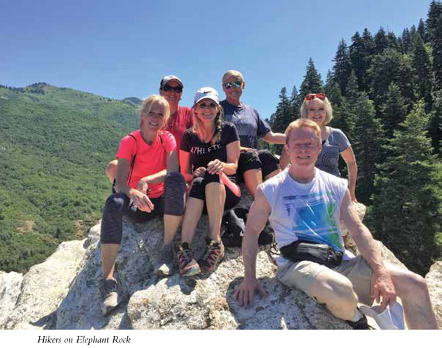
Patches of shade and sun fluctuate along the trail. There is less elevation gain from here to the giant gray rock jutting out from the surrounding green of the forest—Elephant Rock.
At 1.7 miles the trail breaks through the taller trees and the view opens to the north side of the canyon where you can see a pipeline swath down the opposing mountain face. The “pipeline” is a wide treeless strip that looks like a ski run and is cleared to the top of the mountain. This swath is what remains of the placement of a 900-mile-long gas pipe that was built to carry natural gas from southwestern Wyoming to southern California.
The trail quickly heads back into the trees as it cruises deeper into the hills toward Elephant Rock. The occasional wooden bridge helps you cross any watery sections. Just before reaching Elephant Rock, you will hit a T in the trail. Look closely for this, as it appears to be a sharp right turn up the mountain. Take the left leg, which sweeps around the corner to a set of benches and Elephant Rock below. The right fork, which is a sharp turn to the south, continues on to Rudy’s Flat and North Canyon if you wish to continue with either option.
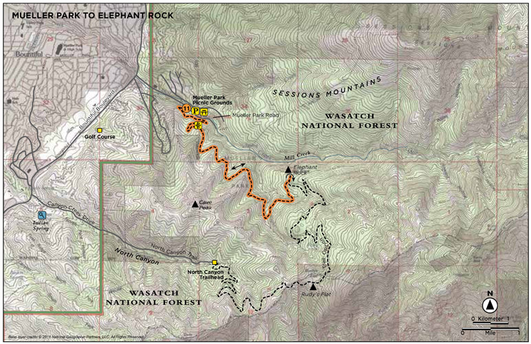
From the benches above Elephant Rock, Mueller Park stretches below, as do Bountiful, the foothills, the Great Salt Lake, Antelope Island, and everything between. A steep footpath leads down to Elephant Rock if you wish to climb onto the rock itself. Enjoy the view before returning the way you came.
Utah has five national parks and ten national monuments and recreation areas.
Miles and Directions
0.0 Start at Mueller Park picnic grounds and trailhead.
0.6 Come to the first scenic overlook.
1.0 After achieving most of its elevation gain, the trail begins a meandering eastern route into the mountains.
1.7 The trail opens for a scenic overlook to the north of the canyon. Elephant Rock is clearly visible from here.
3.5 Take the left fork to Elephant Rock. Return the way you came. (Option: Rudy’s Flat and North Canyon can be reached by turning right at the last fork before Elephant Rock.)
7.0 Arrive back at the trailhead.
Option
Mueller Park to North Canyon point-to-point hike: With a shuttle you can continue from Elephant Rock, past Rudy’s Flat, and down North Canyon. This route will add 6.0 miles to the featured hike for a total one-way trek of 9.5 miles. North Canyon sits right at the top of a neighborhood—literally 50 feet from the nearest house—so access is easy but parking is limited.
To leave your shuttle vehicle at North Canyon, take I-15 to the 26th South exit 315 in Bountiful. Drive east to 1800 South and turn right (east). Follow 1800 South for 1.7 miles to Bountiful Boulevard and turn right (south). Follow Bountiful Boulevard for 1.6 miles to Canyon Creek Drive, which ends after 0.8 mile. This is the mouth of North Canyon. No parking is allowed in this circular turnaround. Parking for a couple cars is available a short way up the canyon road in a pullout. (Bountiful City has plans to build an established trailhead here.)
Hike Information
Local events and attractions: Mueller Park picnic grounds are open 7 a.m. to 10 p.m. There are ten single sites and two group sites that can accommodate up to one hundred people. Reservations are suggested, but there also are first-come, first-served sites. Reservations are required at least 5 days in advance and can be made at www.reserveamerica.com. There is a fee to enter the picnic grounds, and extra vehicle fees are charged. Dogs are allowed but must be on a leash at all times. Call (801) 292-2800 for more information.
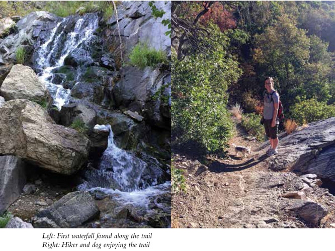
A 30-foot waterfall near the top, open views of the canyon, tumbled and shot-up early-20th-century cars hidden in the trees, and the wonder of Farmington Creek are the interesting highlights of this easy-access trail located just up Farmington Canyon. The trail begins in a gravel parking lot at the point where the road up Farmington Canyon changes from paved to gravel. The trail cuts quietly up the canyon paralleling Farmington Creek up to Sunset Campground, a primitive Forest Service campground. The views across the canyon, down to the creek, and out to the Great Salt Lake add to the flavor of the family-friendly trail.
Start: Gravel parking area off Farmington Canyon Road
Distance: 3.8 miles out and back
Hiking time: About 2.5 hours
Difficulty: Easy
Elevation gain: 1,110 feet
Trail surface: Dirt and rock path
Best season: Spring, fall, and winter. (The trail has complete southern exposure and gets very hot during the summer.)
Other trail users: Bikers, horses
Canine compatibility: Dogs permitted
Land status: Uinta-Wasatch-Cache National Forest
Nearest town: Farmington
Fees and permits: No fees or permits required
Maps: USGS Bountiful Peak, Peterson; A guidebook called Guide to Farmington Trails is available for purchase at 160 South Main St., Farmington, at the City Hall.
Trail contacts: Farmington Trails Committee; trail representative changes regularly. Farmington City can direct you to the current contact person, (801) 451-2383; Salt Lake Ranger District, US Forest Service, (801) 733-2660
Special considerations: No ATVs or other motorized vehicles allowed on the trail.
Finding the trailhead: From Salt Lake City head north on I-15 to exit 322. Follow the right fork off the exit ramp. At the first stop sign turn right onto State Street. Follow State Street for 2 blocks to 100 East and take a left. Follow 100 East for 2.3 miles into Farmington Canyon. The road up Farmington Canyon becomes a narrow one-lane road. Travel carefully as cars are allowed to go both directions.
The gravel parking lot is located up Farmington Canyon, on the right at the hairpin turn where the road changes from paved to gravel. Two trails leave the north side of the lot; both are the same trail. A small trail heads off the south side of the parking lot; this is just a user-made trail down to the stream. GPS: N41 00.026’ / W111 59.978’
The Hike
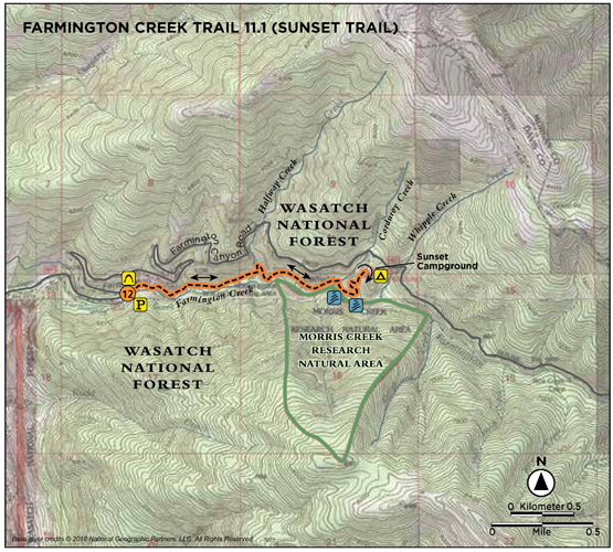
There are big plans for the Farmington Creek Trail. The Farmington Trails Committee plans that this trail eventually will run from Sunset Campground down to the Great Salt Lake, but for now each section, both finished and planned, has a number. Section 11.1 is the top section of the trail that runs from Sunset Campground to the gravel parking area along Farmington Canyon Road. A new section of trail has been completed in the last few years and it begins just above Farmington Pond, but as of the completion of this book, this lower section of trail does not yet connect with 11.1 Sunset Trail.
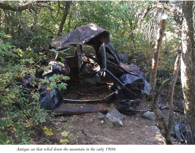
Managed by the US Forest Service, this trail is not always pristine; people have been known to throw old tires and even cars off the canyon road above. The cars found below are early-20th-century models. Everyone can help keep the trail clean by carrying out a little more than you carry in.
Aside from the oddities of the trail, there are beautiful little waterfalls, open views across the canyon, a peaceful path, and a fun waterfall just before you reach the campground. This tributary canyon is a beautiful, peaceful route that climbs deeper into Farmington Canyon, away from motorized vehicles, allowing hikers to enjoy Farmington Creek and the side springs and creeks that tumble down the canyon.
The trail begins by climbing out of the gravel parking area on the north side. Two different trails have been worn into the dirt, but each hooks into the same trail. The trail travels above Farmington Creek, occasionally swooping near a tributary creek or spring. The trail runs high on the north side of the canyon, facing south with clear views across the canyon and down to the creek. Take plenty of water on hotter days, as the open south-facing component of the trail keeps it warm. The sound of the creek is refreshing as you hike, and if you bring a filter, you can purify water from the springs.
The California gull is Utah’s state bird. It won this honor because huge flocks of the birds flew to the rescue of Mormon pioneers by eating a plague of crickets that attacked their crops shortly after they arrived in the Salt Lake Valley.
At 0.9 mile the trail enters aspen trees and passes next to a shaded alcove with boulders for sitting, right off the trail to the left. The first stream crossing is just past this area; a waterfall cascades down, feeding into the stream that hurries down the mountain into Farmington Creek below. The trail crosses and then climbs quickly away from the creek. During spring, when winter runoff is high, the sound of Farmington Creek can be heard all along the trail.
At 1.3 miles the old burned-out car sits off to the right (south) side of the trail. If you don’t watch for it, you might walk right by it. A stream appears quickly at 1.5 miles for another easy crossing. Follow the trail to the right.
The largest waterfall is located just past this point, down off the trail to the right. There is a rock outcropping vantage point for viewing the falls, but some venture down the steep slope to examine the falls close up. Views downcanyon to the valley and Great Salt Lake are visible from here as well.
The trail continues east, and 250 feet later the trail forks. Head left to Sunset Campground, where the trail climbs 240 feet up to the west side of the campground. A wooden trail sign at the campground marks this end of the trail. If you did not leave a shuttle car at the campground, head back the way you came. You can also opt to leave a car at the parking area and hike this trail from the top down.
Miles and Directions
0.0 Start from the gravel parking lot in Farmington Canyon.
0.9 Come to your first stream crossing and waterfall.
1.3 Look for the burned-out car on the south side of the trail.
1.5 The trail crosses the stream and forks; head right.
1.6 Come to the waterfall down off the south side of the trail.
1.7 The trail forks to Sunset Campground.
1.9 Arrive at Sunset Campground. Return the way you came. (Option: Leave a shuttle car at Sunset Campground for a point-to-point hike. The campground is located 3.7 miles from the parking area, farther up Farmington Canyon on the dirt road.)
3.8 Arrive back at the parking area.
Hike Information
Camping: Sunset Campground, Skyline Drive Scenic Backway, Farmington 84025; sixteen sites available for tent and RV camping. Located on Farmington Canyon’s scenic road, this campsite is nestled in the pines, which provide privacy. Vault toilets. No reservations required. Open June 1 through Sept 15. There is a fee to camp.
HOW MANY CALORIES CAN I BURN WHILE HIKING?
According to the Mayo Clinic, 3,500 calories equals about 1 pound of fat. If you want to lose weight, you must burn 3,500 calories more than you take in to burn off each pound. The US Department of Health and Human Services recommends at least 2 hours and 30 minutes a week of moderate aerobic activity (think hiking) or 1 hour and 15 minutes a week of vigorous aerobic activity (think running). Specific calorie burn varies with level of intensity and your individual situation, but according to the Mayo Clinic chart a 160-pound person would burn 188 calories an hour walking (at 2 miles per hour) and 511 calories an hour backpacking; hiking would fall in between. A 200-pound person would burn 228 calories an hour while walking and 637 calories backpacking.