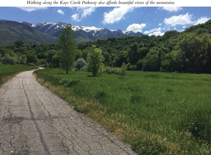
This Layton city park contains 2.5 miles of paved trails that run through 100 acres of sometimes-dense vegetation and more-open marshland. Although just minutes from large subdivisions and busy streets, the park is a quiet retreat in the bottom of Hobbs Hollow. Running through Kays Creek corridor, the east side of the trail runs next to Hobbs Reservoir and often next to Kays Creek. It’s a quick retreat from the bustle of city life and a haven filled with a variety of wildlife and birds. Five trailheads provide a variety of access points, and the trails can be enjoyed in multiple directions. Pick one, or stroll them all.
Start: There are five trailheads: (1) Adam J. Welker trailhead, 2700 North 2125 East. This trailhead has twenty-five parking spaces and is considered the parkway’s primary trailhead. (2) Canyon View trailhead, 2360 East Canyon View. No parking available. (3) Oak Forest trailhead, 2459 East 2750 North. No parking available. (4) Hidden Hollow, 2210 North 1450 East. Parking possible along the roadside. (5) Sunset Drive trailhead, 1851 E. Sunset Dr. No parking available.
Distance: 2.5 miles of trails
Hiking time: About 30 minutes to 2 hours
Difficulty: Easy
Elevation gain: Adam J. Welker trailhead to Oak Forest trailhead, 225 feet; Adam J. Welker to dead end at Kays Creek, 190 feet; Adam J. Welker to Canyon View trailhead, 168 feet; Adam J. Welker to Hidden Hollow trailhead, negligible
Trail surface: Paved and dirt
Best season: Year-round access
Other trail users: Bikers, skateboarders, people in wheelchairs and pushing strollers
Canine compatibility: Leashed dogs permitted
Land status: City park
Nearest town: Layton
Fees and permits: No fees or permits required
Schedule: Parkway open 1 hour before sunrise to 1 hour after sunset
Maps: Layton city and Kays Creek Parkway maps available online at www.laytoncity.org
Trail contacts: Layton City Offices, Parks and Recreation Department, 437 North Wasatch Dr., Layton 84041; (801) 336-3900
Special considerations: No motorized vehicles or fires allowed. No restrooms are available at any trailhead. No alcohol allowed.
Finding the trailhead: The Adam J. Welker trailhead is the only trailhead to provide parking, so it is the best trailhead for nonlocals. From Salt Lake City take I-15 north to the US 89 turnoff in front of Lagoon Amusement Park (exit 324). Follow US 89 for 8.7 miles to UT 193 (exit 404) and go toward Clearfield/Hill Air Force Base. Turn left off the exit ramp onto UT 193/Bernard Fisher Highway and travel 1.1 miles. Turn left onto 2000 East and then left onto Deere View Drive and continue 0.1 mile. Turn right onto 2125 East and follow the road 0.4 mile to where it dead-ends at the trailhead and parking area. GPS: N41 05.867' / W111 55.687'
The Hike
For his Eagle Scout project, in 2008 a local Scout put up information signs along the trail describing the flora and fauna of the area. The signs provide information on raccoons, porcupines, deer, cougars, red-tailed hawks, mourning doves, spotted towhees, red foxes, and magpies—all found at different times of the year in this patch of nature within the city. The trail is lined with Russian olive trees, so during spring the aroma is divine. A variety of trees and undergrowth provide a haven for birds and wildlife, while pulling us out of neighborhoods and into a peaceful, quiet stroll along Kays Creek, for which the parkway is named. Walking the trails affords you the sound of Kays Creek, birds, and crickets. Hobbs Hollow, the canyon the park is located in, sits well below the numerous neighborhoods that rim the area.
The five different trailheads allow access to Kays Creek Parkway from various neighborhoods around the east side of Layton, but only one provides parking—Adam J. Welker. This land was provided by the Welker family, which donated 20 acres to the park project.
The park covers an underground sewer line that services the surrounding neighborhoods. There are plans that someday the trail will continue west, expanding to Layton Commons Park.
Heading east for 0.3 mile from Adam J. Welker trailhead and parking lot, you will reach a fork in the trail. The right fork ascends 0.65 mile to Oak Forest trailhead, which sits in a neighborhood. The left fork takes you to the Canyon View access and farther into the hollow and to a Kays Creek bridge and crossing. There is a picnic table at the bridge crossing, and the trail continues for another 0.25 mile until it dead-ends at a grove of trees. It is 1.6 miles from Adam J. Welker trailhead to the dead end past Canyon View trailhead. Hobbs Reservoir, used for irrigation, is well fenced off on this east side of the parkway. Walk-in only access is allowed to the reservoir from Canyon View Drive trailhead and Oak Forest trailhead. There is also access from the east side of the reservoir on a dirt trail, but it is difficult to find. Fishing is allowed and nonmotorized watercraft can be used, but swimming is prohibited. Built in 1919 the reservoir is of earthen construction with a capacity of 1,580 acre-feet and drains an area of 2 square miles.

If you head west from Adam J. Welker trailhead toward the Hidden Hollow and Sunset Drive trailheads, the vegetation is more marshland than forest. In 0.35 mile the trail forks; both forks head in the same direction and loop back together in 0.2 mile. It is 0.7 mile to the Hidden Hollow trailhead and 0.5 mile to the Sunset Drive trailhead.
Garbage cans and doggie potty bags are available at all trailheads. Enjoy any section of the trail or all for as long as you like, and then return to your car.

Miles and Directions
0.0 Start at the Adam J. Welker trailhead. There are 2.5 miles of possible trails within the parkway.
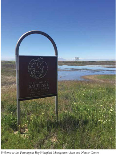
The Great Salt Lake Nature Center at Farmington Bay Waterfowl Management Area is a great place to observe four different types of habitat: upland, emergent marsh, big open water, and riparian. Different birds and animals frequent each type of habitat, including a range of raptors and hundreds of other species. These marshy wetlands are a waterfowl sanctuary, and in 2010 a nature trail was created that circles through sections of these habitats to take birding to the next level. Famous for the numerous bald eagles that winter here, the nature center also sees international visitors, especially during February, the height of the season, when the on-site bald eagle count ranges from 100 to 400. This easy, pleasant trail provides bridges over marshy areas and observation decks with benches for sitting, waiting, and enjoying the birding experience. It is a peaceful foray perfect for families and is wheelchair accessible. A new nature center, the Robert N. Hasenyager Great Salt Lake Nature Center, will be installed in mid-2018 and will provide maps and information on the birds and surrounding area.
Start: Northeast of the nature center off the main road
Distance: 1.3-mile horseshoe; 1.5 miles if you take trail spurs to observation blinds on Big Pond
Hiking time: About 1 hour
Difficulty: Easy
Elevation gain: Negligible
Trail surface: Gravel and boardwalk
Best season: Year-round; snowshoes potentially required in winter; Feb for bald eagles
Other trail users: Bikers, people in wheelchairs
Canine compatibility: Dogs permitted on leash during the off-nesting season (Sept 16 through Feb 29). Leashes protect the wildlife from upset and protect your dog from interaction with traps, raccoons, and other wildlife.
Land status: Waterfowl management area
Nearest town: Farmington
Fees and permits: No fees or permits required
Schedule: Open during daylight hours. Nature center open 5 to 7 days a week during daylight hours.
Maps: Great Salt Lake Nature Center trail map, available at the nature center/trailhead
Trail contacts: Robert N. Hasenyager Great Salt Lake Nature Center, c/o DWR—Northern Regional Office, 515 East 5300 South, Ogden 84405; and Utah Division of Wildlife Resources at dwrcomment@utah.gov
Special considerations: Take binoculars and your birding book. Mar through Sept is nesting season for bald eagles, so be sure to stay on the trail.
Finding the trailhead: From Salt Lake City head north to Farmington on I-15. Take exit 322 (UT 227) and go right at the fork. Turn right onto the frontage road for 0.6 mile and then right onto Glovers Lane/925 South. Head straight west on Glovers Lane for 1.9 miles to the second turnoff into the waterfowl management area. Turn left (south) and follow the road to the nature center and parking area. If the gates are closed you can park outside the gates and enter by foot. The trails take off from the parking area. There are two gravel trails; start at the one farthest north. The south trail is the exit. GPS: N40 57.745' / W111 56.662'
The Hike
In 1935 the National Park Service, Utah Fish and Game Department, and the Civilian Conservation Corps joined forces to work on the eastern shores of the Great Salt Lake and the improvement of 3,800 acres of avian habitat. From that early start the Farmington Bay Waterfowl Management Area had grown to 18,000 acres as of 2007.
There seems to be a hundred-year cycle where the Great Salt Lake rises substantially, and as a terminal basin with no outflow, these rising lake levels cause a large disruption by flooding the surrounding area. As the climate shifts and the Great Salt Lake recedes, the mudflats are exposed for wildlife. These marshy wetlands are used as a waterfowl sanctuary. A small nature center was erected in 2007 to educate the public on this ecosystem and the wonderful refuge it provides along the migratory routes of millions of birds. A new and modern nature center was erected in 2018 to expand the services and education available at the refuge. Biologists have documented 200 species of birds at the bay and as many as 400 bald eagles during the winter months. More than five million birds are estimated to visit the bay each year.
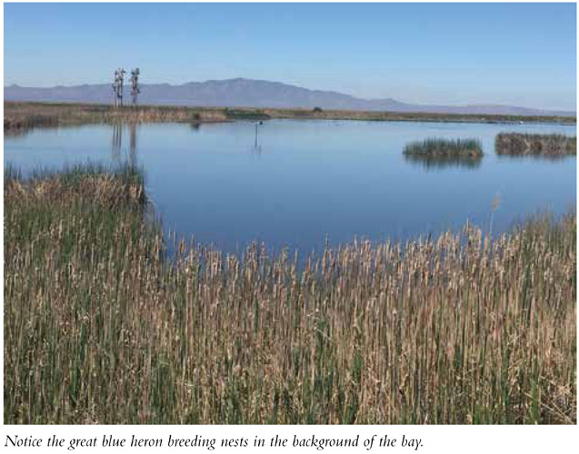
The trail was built through four different habitats to give walkers and birders a chance to see a variety of birds. Of special note are a great blue heron rookery on Glover Pond and viewing decks on Big Pond. Maps available at the nature center further explain the various habitats.
The trail begins a few hundred feet back down the road, northeast of the nature center. There are two gravel trails with entry to the road—each one end of the trail. Start at the one farthest north, which immediately brings you to East Pond, a pond fed by Farmington Creek. The Emergent Marsh is next. The marsh is wet year-round and is filled with tall cattails and bulrushes. You pass two observation blinds on the right side of the trail in the next 0.25 mile.
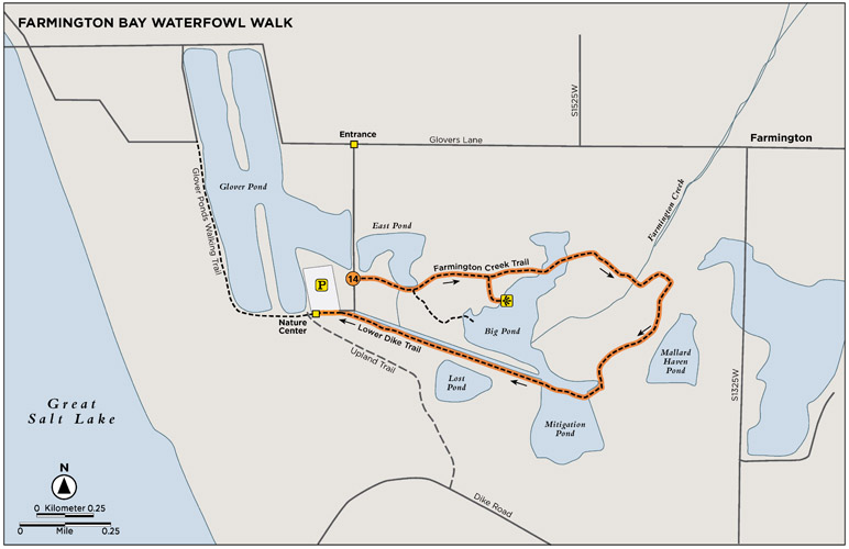
The trail continues along gravel and boardwalk as it makes its way around Big Pond, Mallard Haven Pond, Mitigation Pond, Lost Pond, and finally to the Western Chorus Frog Area. The trail is 1.3 miles long without the side trips to lookout points—1.5 miles with the forays to the observation blinds. The trail makes a horseshoe as it explores the area and exits along the road just south of where the trail started.
Miles and Directions
0.0 Start at the second, wide gravel trail that sits back up the road from the nature center.
0.04 Within 200 feet the East Pond and Emergent Marsh habitat begin.
0.5 Reach the Big Pond area.
1.3 Arrive at the nature center if you do not take side trails to bird observation points.
1.5 Arrive at the nature center if you do take side trails to bird observation points.
Options
Two other, unimproved trails start at the nature center. One rims Glover Pond to the west and is an excellent place to view shorebirds and waterfowl. It is 1.0 mile out and back. The Upland Trail (1.0 mile) wraps to the southwest of the nature center. Both trails are indicated by nothing more than mowed grass, but they give you the opportunity for a pleasant walk.
Hike Information
Organizations: Farmington Trails Committee, Farmington City; (801) 451-2383
Camping: Lagoon RV Park and Campground, 375 North Lagoon Dr., Farmington 84025; (801) 451-8100. Open May through Oct; reservations recommended. The Lagoon Amusement Park is the largest in Utah.
EDIBLE WATER PLANTS OF UTAH
These edible wild plants are common in areas with rivers, lakes, streams, and creeks:
Water lily: Found floating on ponds and lakes; the flowers, seeds, and rhizomes of the water lily are all edible. According to Terry Ellefsen from eHow, one can “peel the corky rind of the rhizome to uncover an edible plant that can be eaten raw or dried and ground into flour. The seeds of the plant can also be dried and made into flour.”
Cattails: Many parts of the funny-looking waterside plant that appears to be a stem with a hot dog on top are edible. Young shoots can be eaten raw or boiled, while the bottom section of the stem is reported to taste like cucumber when eaten raw. When the seed heads are young and green, they can be boiled and eaten like corn on the cob.