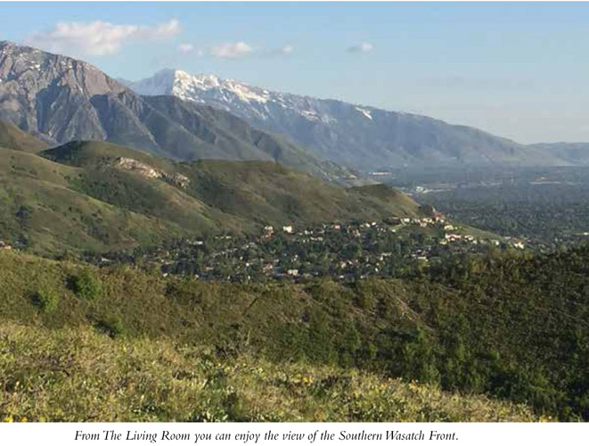
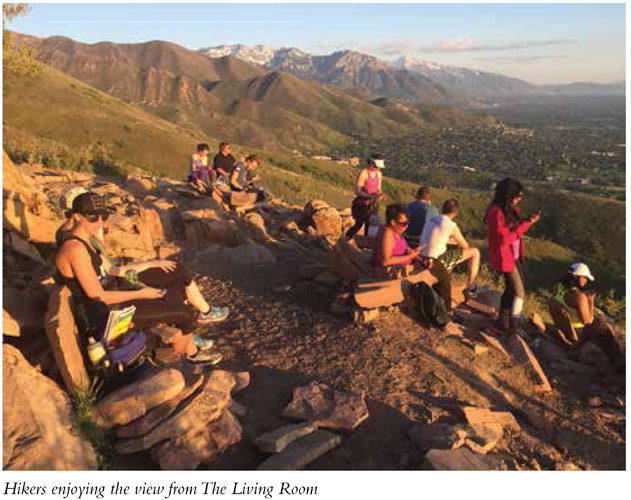
After a nice hike, what’s better than kicking back in the living room and propping the old feet up with a cool drink? On this hike you get this opportunity even before you hike back down the trail. Just make sure your water bottle has ice in it, and you’ll be set. The Living Room affords a view across the valley to the west, so hikes to watch the sunset are a favorite. This view can be enjoyed while sitting on chairs and couches built of slabs of stone and resting your feet on stone ottomans. The high-definition view of the valley below is better than anything you’ll get at home. With an easy-access trailhead in the foothills behind the University of Utah, this popular trail sees a lot of traffic. Not too long, and kid appropriate, the whole family can enjoy the fun of this trail. It has also become a favorite of trail runners.
Start: Second trailhead along the east side of Colorow Way
Distance: 2.6 miles out and back
Hiking time: About 2 hours
Difficulty: Moderate
Elevation gain: 1,000 feet
Trail surface: Rock, gravel, dirt
Best season: Late spring through fall
Other trail users: None
Canine compatibility: Leashed dogs permitted
Land status: Uinta-Wasatch-Cache National Forest
Nearest town: Salt Lake City
Fees and permits: No fees or permits required
Schedule: The trail is often used at night to enjoy the views of the sunset and lights of the city.
Maps: USGS Fort Douglas
Trail contacts: Salt Lake Ranger District, 6944 South 3000 East, Salt Lake City 84121; Uinta-Wasatch-Cache National Forest, 8236 Federal Building, 125 South State St., Salt Lake City 84138
Special considerations: The trail officially climbs up George’s Hollow, and you’ll notice a maze of trails in the area. There is more than one way to the top, but to make sure you don’t miss The Living Room, follow the suggested route until you are familiar with the area and location.
Finding the trailhead: From Salt Lake City take I-80 east to exit 129 (Foothill Drive). Continue north on Foothill Drive for 3.1 miles to Wakara Way (670 South). Head east 0.7 mile to Colorow Way (2310 East) and turn right onto Colorow Way just before the entrance to Red Butte Gardens. Continue on Colorow Way to the second trailhead on the left.
Alternate route: Take the 400 South Exit from I-15 in Salt Lake City. Head east on 400 South for 4 miles to Wakara Way. Turn east/left on Wakara Way 0.7 mile to Colorow Way (2310 East) and turn right onto Colorow Way just before the entrance to Red Butte Gardens. Continue on Colorow Way to the second trailhead on the left. No markers name the trail but it is generically signed, and bags are provided to clean up after Fido. GPS: N40 45.560' / W111 49.277'
The Hike
The Living Room sits above the University of Utah and Fort Douglas. The easy-access trailhead makes it a favorite with college students, trail runners, and people who work in the research park below. It can be a quick workout or a romantic place to watch the sunset, but either way the trail is well traveled. The trail cuts off from the Bonneville Shoreline Trail (BST) into George’s Hollow directly behind the research park.
The trail begins under a canopy of trees and forks within a few hundred feet. Both forks cross over a very small stream and connect again to one another.
At 0.2 mile you hit the Bonneville Shoreline Trail (wider gravel path leading north and south). Although the dirt hiking trail you are on appears to head straight up the mountain, instead head to the right along the BST for 50 feet or so to another dirt trail that heads up the mountain. This trail will take you to George’s Hollow. In 0.1 mile the trail intersects with a wider gravel trail and turns left toward the canyon. Head left and stay on this main trail as it heads up George’s Hollow, skipping the two side trails that enter from the left.
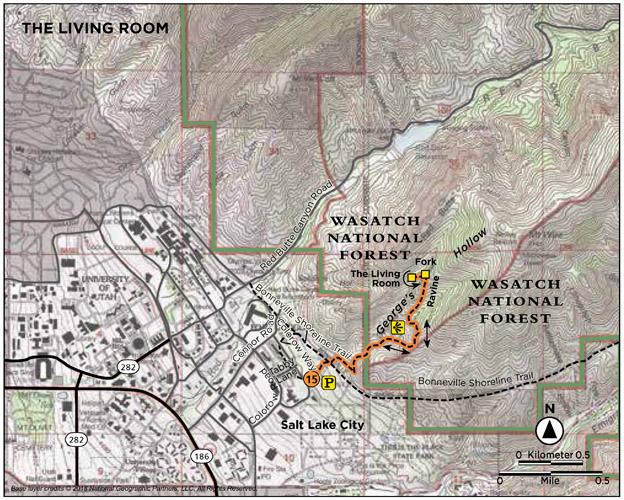
The trail forks again at 0.4 mile. Take the right fork and continue east up into the canyon. The wider, better established trail has old railroad ties for footing. Gambel oak and bigtooth maple snuggle up to the trail.
At 0.54 mile the trail curves into a ravine and climbs up for a view across the Wasatch Front. This vantage point provides a pleasant view and rest stop. From here go right, up the steep incline following the well-established trail. At 1.2 miles, the trail forks one last time just before you get to The Living Room. Take the left fork and follow the trail around to the front side of the mountain, where you will find the seating arrangements waiting and the view impressive.
The view looks out to the Oquirrh Range to the west and down onto the University of Utah, the research park, and Salt Lake Valley below. Slabs have been stacked to make this Flintstones sitting area. Chances are you will not be the only one kicking back.
The Oquirrh Range is 30 miles long and makes up the western border of the Salt Lake Valley. The name Oquirrh was taken from a Goshute word meaning “wooded mountain.”
Miles and Directions
0.0 Start at the Colorow Way trailhead.
375 feet Reach the first fork; head right or left.
0.2 Hit the Bonneville Shoreline Trail.
0.25 Turn off Bonneville Shoreline Trail and head up mountain.
0.3 Turn left on gravel trail heading toward George’s Hollow.
0.4 Trail forks head right.
0.8 Climb up the ravine.
1.0 The trail opens to an overlook view to the west.
1.2 Reach final fork; head left around to the front of the mountain.
1.3 Arrive at The Living Room. Return the way you came.
2.6 Arrive back at the trailhead.
Hike Information
Local events and attractions: Red Butte Botanical Garden and Red Butte Canyon are northern neighbors to this trail. Red Butte itself is a steep foothill that rises more than 1,500 feet in just over a mile. Red Butte Gardens offers a summer concert series, and a hike around the beautiful gardens can be peaceful. For more information call (801) 585-0556 or visit www.redbuttegarden.org.
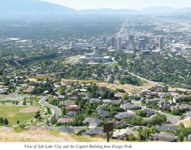
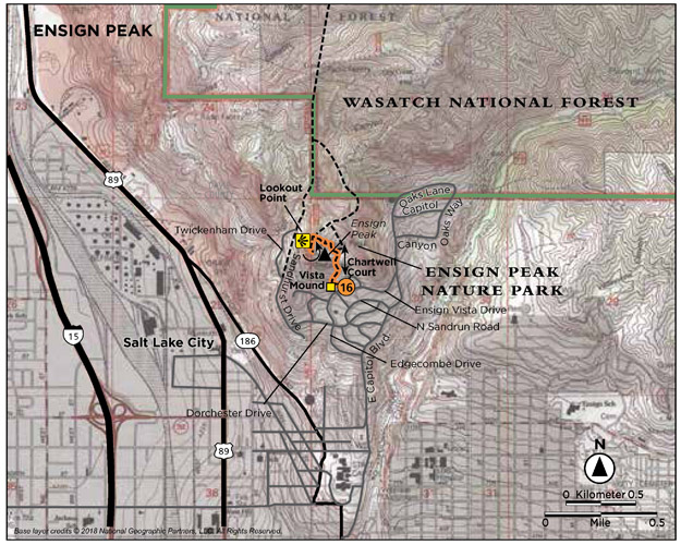
The historic Ensign Peak Trail climbs to an overlook used by Brigham Young and other Latter-Day Saint church leaders upon settling the valley. The viewpoint from the historical obelisk atop the peak provides a view of the Salt Lake Valley as it sits cradled between the Wasatch Mountains on the east and the Oquirrh Range on the west. This short hike up a barren, grass-lined trail takes you to the point where you can view it all—both mountain ranges, the valley between, the Great Salt Lake, the heart of downtown Salt Lake City, and everything in between. This hike is all about the view and the history.
Start: Ensign Peak Nature Park
Distance: 1.0 mile out and back
Hiking time: About 30 minutes
Difficulty: Moderate due to steepness of trail
Elevation gain: 398 feet
Trail surface: Dirt path with a paved section
Best season: Year-round
Other trail users: None
Canine compatibility: Leashed dogs permitted
Land status: Salt Lake City park, managed by the city and the Ensign Peak Foundation
Nearest town: Salt Lake City
Fees and permits: No fees or permits required
Schedule: Open daily sunrise to sunset
Maps: USGS Salt Lake City North; Ensign Downs Park
Trail contacts: Salt Lake City Parks and Public Lands; (801) 972-7800
Special considerations: Stay on the designated trail to protect the native grasses and flowers.
Other: No water or restrooms are available at the trailhead. Carry out your own trash. No campfires or camping permitted.
Finding the trailhead: From the State Capitol building in Salt Lake City, take East Capitol Boulevard (135 East), the road found on the east side of the Capitol building, north for 0.5 mile to Edgecombe Drive (800 North). Turn left onto Edgecombe Drive, which becomes Ensign Vista Drive, and continue for 0.2 mile to the Ensign Peak Nature Park trailhead and entry plaza on the left. GPS: N40 47.518' / W111 53.291'
The Hike
On July 26, 1847, 2 days after Mormon prophet Brigham Young declared Salt Lake Valley the place where his followers were to set up their new community, he and a party of prominent church leaders climbed this hill as a vantage point to survey the valley and decide how they would lay out their future city. It was suggested that this peak was a fitting place to set up an ensign, and it was named Ensign Peak. On July 26, 1934, an obelisk was erected atop the peak. Today the hike to overlook the entire valley is defined by a dirt path lined with information markers describing the history, geology, flora, and fauna of the area.
As you head up the trail you immediately come to the Vista Mound offshoot trail to your left. This side trail is a nice lookout point from which you can see the Oquirrh Mountains to the west; Kennecott Copper Mine to the southwest; and downtown Salt Lake City, the Capitol Building, Temple Square, the University of Utah, and the Wasatch Mountains to the east. The first path to Vista Mound is a short steep paved trail. The second is found 400 feet up the trail and is a dirt path that leads out to Vista Mound.
The trail is lined with grasses, thistle, and Gambel oak, but no shade. The well-marked trail provides places to sit if you tire on the steady climb to the top.
On the way up there are two additional overlooks. The first, at 0.33 mile, is called Valley View and it is marked by stone seats and an informational marker about the valley. You can sit, read, and take in the view. The second is called the Great Salt Lake overlook. It is found at 0.38 mile where the trail splits. The right fork goes to the Great Salt Lake Overlook and you can look down on the industrial area at the northern point of the mountain moving into Davis County. You can also see the Great Salt Lake, Antelope Island, and the north corner of the Oquirrh Mountains. The left fork takes you straight to Ensign Peak. Both connect with each other.
The Great Salt Lake is 80 miles long and 30 miles wide, with an average depth of 13 feet. The shoreline changes dramatically with any change in depth.
The view from the top overlooks the entire Salt Lake Valley. The obelisk holds a historic plaque, and railings line the walking deck.
On July 26, 1996, president of the Church of Jesus Christ of Latter-Day Saints, Gordon B. Hinckley, dedicated Ensign Peak Nature Park, which included Ensign Peak and an additional 66 acres surrounding it. President Hinckley dedicated it that it may “be a place of pondering, a place of remembrance, a place of thoughtful gratitude, and a place of purposeful resolution.” The effort was headed by the Ensign Peak Foundation, later known as the Mormon Historic Sites Foundation, which worked closely with the Salt Lake City Corporation. The Church of Jesus Christ of Latter-Day Saints also constructed a memorial garden near the base of the peak that tells of its significance and the early pioneers who built up Salt Lake Valley.
Brigham Young laid out Salt Lake City with wide streets and 10-acre blocks. The temple block was to be the heart of the city. When the temple was finished in 1893, the population of Salt Lake City was 45,000. Today the population of the Wasatch Front is estimated to be more than two million strong. Finding your way around the Salt Lake area is easy in the areas that are on this acre-block grid system. Addresses are plotted on an east–west and north–south grid moving out from Main Street running north and south and Center Street running east and west.
After enjoying the vast vista, return to the trailhead the same way you came up.
Miles and Directions
0.0 Start at the trailhead in Ensign Peak Nature Park.
100 feet Trail forks. Vista Mound trail to the left. Ensign Peak to the right.
400 feet Second trail split for Vista Mound.
0.33 Valley View viewpoint.
0.38 Reach the overlook with a westerly view to the Great Salt Lake and north to the industrial area below.
0.5 Arrive at Ensign Peak summit. Return the way you came.
1.0 Arrive back at the trailhead.
Hike Information
Local Sightseeing: Salt Lake City Convention and Visitors Bureau, www.visitsaltlake.com; for guided city and historic tours. Temple Square also has free tours for the public.