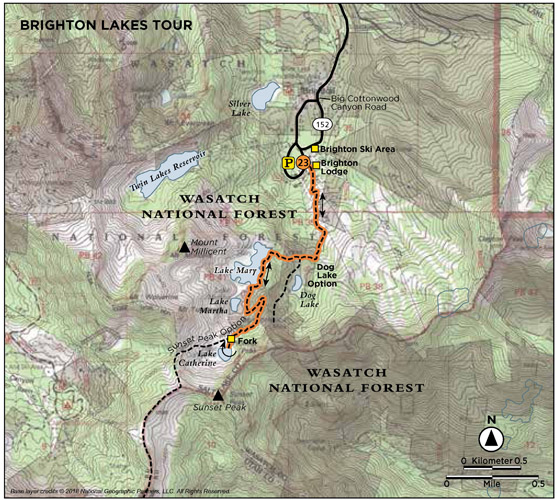
The Brighton Lakes Trail passes three lakes: Lakes Mary, Martha, and Catherine. Before you come to the first lake, there is also a spur to Dog Lake, which sits only 500 feet off the main trail. Known for its lush summer wildflowers, this area is the home of the Wasatch Wildflower Festival, and during late July and early August wildflowers typically line the path. This is a popular, family-friendly hike, and you will find people of all ages making the trek to these scenic alpine lakes. This hike often makes the list of Most Family Friendly Hikes near Salt Lake City.
Start: Lake Mary/Catherine Pass trailhead, south of the Brighton Center
Distance: 4.4 miles out and back
Hiking time: About 2.5 hours
Difficulty: Moderate
Elevation gain: 1,100 feet
Trail surface: Gravel and dirt path
Best season: Summer and fall
Other trail users: Mountain bikes allowed but not recommended
Canine compatibility: Dogs prohibited (Big Cottonwood Canyon is a watershed.)
Land status: Uinta-Wasatch-Cache National Forest; Brighton ski resort
Nearest town: Brighton
Fees and permits: No fees or permits required
Maps: USGS Brighton Quad
Trail contacts: Salt Lake County Parks and Recreation, (385) 468-1800; Salt Lake Ranger District, 6944 South 3000 East, Salt Lake City 84121; Uinta-Wasatch-Cache National Forest, 8236 Federal Building, 125 South State St., Salt Lake City 84138
Special considerations: Watch out for moose around the lakes; never approach wild animals. Remember your insect repellent—mosquitoes breed near bodies of water.
Other: Big Cottonwood Canyon is a protected watershed area for Salt Lake City and the Wasatch Front. No swimming or wading is permitted in any lake, no domestic animals are allowed in the canyon, and no camping is permitted within 200 feet of any lake or stream.
Finding the trailhead: The Lake Mary/Catherine Pass trailhead sits at the very top of Big Cottonwood Canyon at the base of Brighton ski resort. Travel 15 miles up Big Cottonwood Canyon to a one-way loop; just continue driving and the loop will bring you to Brighton ski resort. Park in the big parking area next to Brighton Center Lodge. The clearly marked trailhead is to the south of the lodge. GPS: N40 35.897' / W111 35.053'
The Hike
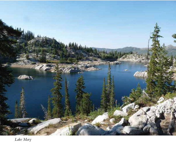
The Brighton Lakes tour takes you into a high alpine environment complete with a stream, lakes, flowers, the occasional moose sighting, and wonderful views. Because it is popular, as it has been since early pioneer days, you will almost always find others on the trail with you. The trail is not too steep, and the lakes are fun destinations. Lake Mary was originally much smaller, but it was dammed in 1915 and Lake Mary and Lake Phoebe were combined. The dam, just over 1.0 mile up the trail, helps regulate the water flow of the watershed area. Lake Martha lies only 0.5 mile later but is very different from Lake Mary’s granite cliff border and granite island. Lake Martha is surrounded by forest and open meadow. Lake Catherine, just 0.7 mile after Lake Martha, is the highest lake in the basin.
The trail begins with 200 feet of rocky gravel placed between railroad ties and then curves to the right and heads up the mountain. Follow the signs to Lake Mary. The trail climbs beneath the ski lift and between fields of flowers during July and August. Asters, Coville’s columbines, fireweed, speckled rockets, lupines, geraniums, giant coreopsis, tie-dye roses, Indian pain tbrush, Jacob’s ladder—they are all here, and the trail is rich with color.
At the fork for Dog Lake (left) at 0.8 mile, you can also break to the right for your first overlook down over Brighton and into Big Cottonwood Canyon below and to the right. Enjoy both.
Shortly after this point the trail climbs next to a stream draining from Lake Mary. Climb a stone staircase to the lake while enjoying the pleasant gurgle of the stream. From here you get your first sightings of the dam. The trail climbs up and around the south side of the dam to Lake Mary.
Continue along the path that follows the east side of Lake Mary as it heads up the mountain. Lake Mary is nestled at the base of the cirque amidst granite mounds, walls, and crumbling chunks of the rugged mountains surrounding it.
At 1.4 miles you come to a fork in the trail. The right fork takes you to the other side of Lake Mary. Take the left fork to continue another 0.1 mile to Lake Martha.
From Lake Martha you will climb onward to Lake Catherine. Along the trail you will quickly be able to look down to your left and see Dog Lake below. This gives a whole new perspective to where you are and where you’ve been.
A half mile later (2.1 miles) another fork splits the trail. The right fork will take you to Catherine Pass; take the left to reach Lake Catherine at 2.2 miles.
Blast those blisters: Carry moleskin, adhesive bandages, or gauze and tape. Cut a circle of moleskin and remove the center to relieve pressure on the blister.
In 1871 William Brighton and Catherine Bow brought their family to the top of Big Cottonwood Canyon. Loving the alpine scenery and the fishing, they built a summer cabin. Within a couple years they built a single-story hotel, for the miners who traveled between Alta and Park City. Catherine was known as an expert fisher-woman, and she fed her guests well. Lake Catherine and Catherine Pass are named for her.
According to the Big Cottonwood Stream Survey Report, Big Cottonwood Creek is home to rainbow, brook, and brown trout and the native Bonneville cutthroat trout. The Utah Division of Wildlife Resources stocks the creek with rainbow trout annually near Silver Lake next to Brighton. The water from Brighton Lakes flows into Big Cottonwood Creek.
Enjoy Lake Catherine and then return the way you came, or head up to Catherine Pass for a longer foray.
Miles and Directions
0.0 Start at Lake Mary/Catherine Pass trailhead.
0.8 Reach the fork to Dog Lake. Dog Lake Spur (left) is a short 500-foot trek off the main trail. Dog is a small lake that sits in its own little canyon. The quick, easy side trip allows you to take in all four area lakes in one hike.
1.1 Reach Lake Mary.
1.4 Come to the fork in the trail that will take you around Lake Mary; take the left fork to continue to Lake Martha.
1.5 Reach Lake Martha.
2.1 Reach a fork in the trail; bear left and continue toward Lake Catherine.
2.2 Reach Lake Catherine. Return the way youcame.
4.4 Arrive back at the trailhead.
Options
Catherine Pass is the mountain saddle located to the west of Lake Catherine. To reach the pass, head right rather than left at the last fork in the featured trail (2.1 miles) before Lake Catherine. The trail will take you to the pass, which connects Brighton and Alta. The trail to Catherine Pass is just over 2.5 miles one way.
From Catherine Pass you can continue on to Sunset Peak, on the southeast corner of Lake Catherine. To reach it, continue up the southeast ridge from Catherine Pass to the peak. This option adds some wonderful views to the beautiful lake hike. See the Catherine Pass and Sunset Peak hike.
Hike Information
Local events and attractions: Wasatch Wildflower Festival; www.wasatchwildflowerfestival.org; usually held the end of July and celebrated primarily at the four main ski resorts in both Big and Little Cottonwood Canyons—near the top of both canyons. A collaboration between the nonprofits Alta Community Enrichment, The Cottonwood Canyons Foundation, and The Snowbird Renaissance Center, the festival is also supported through the efforts of Alta Ski Area, Snowbird Ski and Summer Resort, Solitude Ski Area, Brighton Ski Area, and the US Forest Service.
Camping: The Salt Lake Ranger District manages three campgrounds up Big Cottonwood Canyon (UT 190): Jordan Pines, Spruces, and Redman. Jordan Pines is located 8.8 miles up Big Cottonwood Canyon. To reach the campground turn right onto Cardiff Fork Road across from the Mill D trailhead. The entrance is 0.25 mile from UT 190. Camping at Jordan Pines is by reservation only, and the campground is well suited for groups. Spruces Campground, the largest campground in the Salt Lake Ranger District, is 9.7 miles up Big Cottonwood Canyon. It has ninety-seven campsites with tables, grills, and fire circles. Redman Campground is 13 miles up Big Cottonwood Canyon and has forty-three campsites. There are no RV hookups, and most sites are first-come, first-served.
Camping is permitted in designated campgrounds only. For reservations call the National Recreation Reservation Service at (877) 444-6777 or go to www.reserveusa.com.
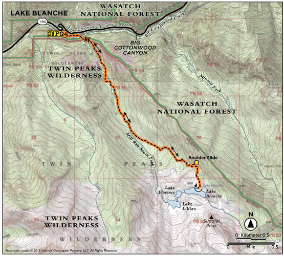
This is not the road less traveled. Though the climb is strenuous, the trailhead is easily accessible, the trail straightforward, and the destination a scenic glacial tarn at the base of Sundial Peak, which lords over the cirque below. One of the area’s more popular hikes, it provides a climb through shaded forest, up canyon meadows, and over glacially cut quartzite to three lakes at the top of the canyon: Lake Blanche and her sister lakes, Lillian and Florence, to the west. Slabs of quartzite and the surrounding forests allow space and time for reflection and exploration once you reach the lakes at the top.
Start: East side of the Mill B South trailhead
Distance: 7.0 miles out and back
Hiking time: About 4.5 hours
Difficulty: Strenuous
Elevation gain: 2,720 feet
Trail surface: Sidewalk, packed-dirt path, rock, boulders, and talus
Best season: Late spring through early fall; avalanche hazard during winter months
Other trail users: None
Canine compatibility: Dogs prohibited
Land status: Twin Peaks Wilderness Area of the Uinta-Wasatch-Cache National Forest
Nearest town: Cottonwood Heights
Fees and permits: No fees or permits required
Maps: USGS Mount Aire
Trail contacts: Salt Lake County Parks and Recreation, (385) 468-1800; Salt Lake Ranger District, 6944 South 3000 East, Salt Lake City 84121; Uinta-Wasatch-Cache National Forest, 8236 Federal Building, 125 South State St., Salt Lake City 84138
Special considerations: Due to the wilderness area and watershed status, no campfires, dogs, horses, or bicycles are allowed. All backcountry camping must be at least 200 feet away from trails, lakes, or streams. There is a limit of ten campers per group.
Finding the trailhead: In Salt Lake City take I-215 south to 6200 South (exit 6). Turn east off the exit and continue along 6200 South as it changes to Wasatch Boulevard for 1.7 miles to the mouth of Big Cottonwood Canyon (UT 190). Turn left (east) at the signal and head 4.2 miles up the canyon to the Mill B South trailhead. The trailhead sits just before the S curves in the road on the right (south) side of the road. If the good-size parking lot is filled, hikers park out along the canyon road. GPS: N40 37.994' / W111 43.420'
The Hike
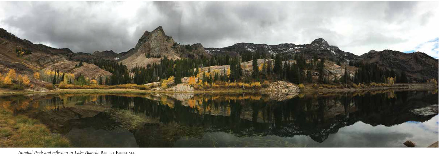
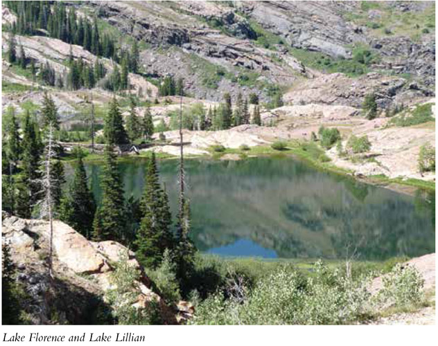
Lake Blanche lies in the upper section of Mill B South Fork. This area has been popular with hikers since the late 1800s when the lakes were named for the daughters of artists Henry L. A. Culmer and Alfred Lambourne. Lake Blanche was named for Blanche Cutler by a friend of Culmer and Lambourne. The names were publicized in their writings and thus stuck. Lambourne was also responsible for the naming of Sundial Peak. The lakes were called the Three Sisters, and the drainage in which they lay was called Hidden Valley. Lambourne was so taken by Hidden Valley that he once spent a summer there, recording his experience in a notebook for others who came after. Today the three lakes have been dammed and are larger than they were in Lambourne’s day.
The trail to Lake Blanche begins near the restroom on the east side of the trailhead. The walkway starts out paved and after 0.25 mile takes off to the right on a trail of dirt and boulders. A sign marker indicates the trail intersection.
Soon after entering the trail, it forks (0.3 mile). Take the left fork and stay on the main trail over the bridge in front of a memorial bench. From here the trail crosses to the north side of the creek and begins its climb up into the canyon. At 0.5 mile the trail enters the Twin Peaks Wilderness area of the Uinta-Wasatch-Cache National Forest. A stream accompanies the trail for this first section as you steadily climb east into the canyon. The trail is well defined and easy to follow.
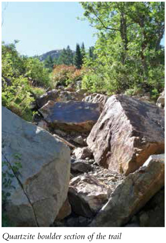
At 3.0 miles the trail changes from its eastern route and begins to switchback up the south-facing mountain to reach the upper cirque. When the trail runs into a quartzite boulder slide, make a small, sharp U-turn and proceed off the slide boulders to the east, where the trail continues. Within a few hundred feet other large quartzite formations become visible. Make your way across these interesting, glacially carved rocks to stay on the trail. Quartzite is prominent the rest of the way to Lake Blanche. Notice the striations on the quartzite that are still visible from the glacial carving that took place during the canyon’s creation.
Big Cottonwood Canyon is bounded on the south by the Lone Peak Wilderness Area and on the north by the Mount Olympus Wilderness Area.
You cannot see Lake Blanche until you’re right upon it. An old dam wall shows past lake boundaries. Follow the wall to crest the rock and look down upon the lake. Head west to the broken dam you can see on the other side of Lake Blanche, from which vantage point you can see Lake Florence and Lake Lillian. The old dams were built in the 1930s to contain much larger lakes. Lake Blanche’s western dam broke in 1983. Footpaths are visible around all three lakes.
Sundial Peak is the majestic mountain that overlooks Lake Blanche from the east. It is as much an attraction as Lake Blanche itself. Take time to enjoy the scenery and peaceful lakeside ambiance before returning the way you came.
Miles and Directions
0.0 Start at Mill B South trailhead.
0.25 Exit the paved path onto a dirt trail.
0.3 Come to your first fork; head left on the main trail, crossing the bridge.
0.5 Enter Twin Peaks Wilderness Area.
3.0 The trail starts switchbacking up the south-facing mountain to climb to the cirque.
3.1 Come to the quartzite boulder slide.
3.5 Arrive at Lake Blanche. Return the way you came.
7.0 Arrive back at the trailhead.
Hike Information
Camping: The Salt Lake Ranger District manages three campgrounds up Big Cottonwood Canyon (UT 190): Jordan Pines, Spruces, and Redman. Jordan Pines is located 8.8 miles up Big Cottonwood Canyon. To reach the campground turn right onto Cardiff Fork Road across from the Mill D trailhead. The entrance is 0.25 mile from UT 190. Camping at Jordan Pines is by reservation only, and the campground is well suited for groups. Spruces Campground, the largest campground in the Salt Lake Ranger District, is 9.7 miles up Big Cottonwood Canyon. It has ninety-seven campsites with tables, grills, and fire circles. Redman Campground is 13 miles up Big Cottonwood Canyon and has forty-three campsites. There are no RV hookups, and most sites are first-come, first-served.
Camping is permitted in designated campgrounds only. For reservations call the National Recreation Reservation Service at (877) 444-6777 or go to www.reserveusa.com.
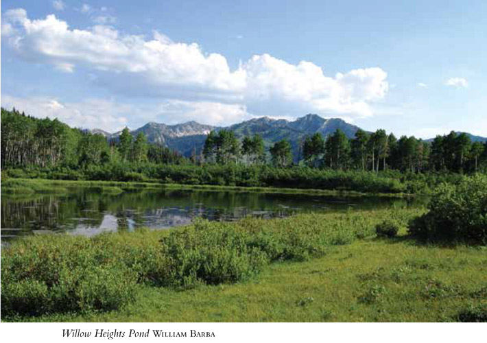
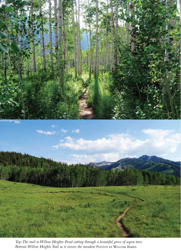
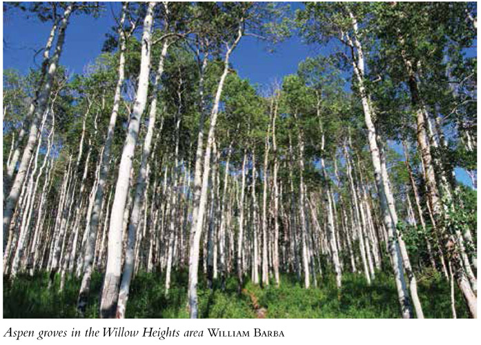
The trail to Willow Heights Pond provides a quick, pleasant outing when you want a short route, a quick climb, a picnic in a place of solitude, or a day with the kids. The trail runs through beautiful aspen groves, which makes fall an especially colorful time to hit the trail, and in summer the trees shade the route nicely. Don’t be fooled by the shortness of the route; it’s still a workout, gaining 600 feet of elevation in 0.75 mile. Enjoy the protected status of the conservation area, and keep an eye out for wildlife.
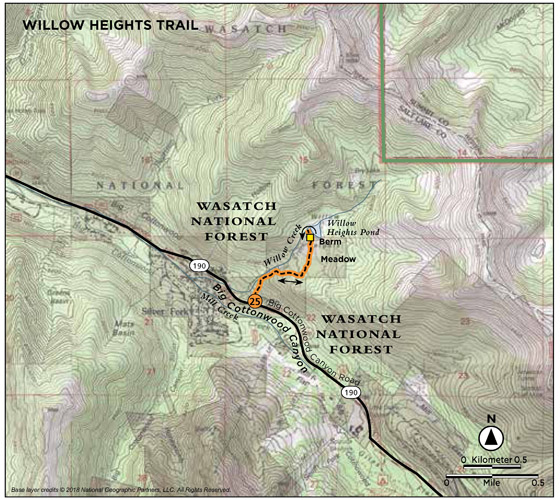
Start: Willow Heights Conservation Area trailhead
Distance: 1.6 miles out and back
Hiking time: About 1 hour
Difficulty: Moderate due to elevation gain
Elevation gain: 600 feet
Trail surface: Rock and dirt path
Best season: Year-round; snowshoes advised in winter
Other trail users: None
Canine compatibility: Dogs prohibited
Land status: Conservation area; watershed
Nearest town: Brighton
Fees and permits: No fees or permits required
Maps: USGS Park City West
Trail contacts: Utah Open Lands Conservation Association, Inc., 2188 South Highland Dr., Ste. 203, Salt Lake City 84106, (801) 463-6156; Save Our Canyons, 68 South Main St., Ste. 400, Salt Lake City 84010, (801) 363-7283; Salt Lake Ranger District, 6944 South 3000 East, Salt Lake City 84121, (801) 733-2660
Special considerations: The ducks that frequent the pond are so comfortable with hikers that they will nibble your feet. Remember not to feed wildlife—it causes the animals to become dependent on human handouts, endangers them by reducing their fear factor, and plays havoc with their natural diet.
Finding the trailhead: From Salt Lake City take I-215 south to 6200 South (exit 6). Turn east off the exit and continue along 6200 South (it changes to Wasatch Boulevard) for 1.7 miles to the mouth of Big Cottonwood Canyon (UT 190). Turn left (east) at the signal. The Willow Heights Conservation Area trailhead sits directly off the road 11 miles up Big Cottonwood Canyon. The trailhead sign is not visible until you get 50 feet up the trail, so use your odometer to find the correct location. There is a yellow “CURVES AHEAD” sign on the right side of the road right at the trailhead. Park along UT 190. The trail takes off from the north side of the road. GPS: N40 37.822' / W111 36.276'
The Hike
In 2000–01 Save Our Canyons helped rally such groups as Utah Open Lands and Utah Growth Commission, in an effort to protect 155 acres of open space up Big Cottonwood Canyon that was being threatened by development. After lengthy negotiations the Willow Heights drainage was purchased from Park City Mines for $2 million. Utah Open Lands oversees the conservation easement for the Willow Heights drainage, which will now be forever preserved. Willow Heights Pond, the surrounding aspen groves, the wildlife that live there, and the watershed are protected under this conservation area. We now get to enjoy the beaver ponds, aspen meadows, and the short but steep climb to the pond.
Willow Heights Conservation Area trailhead is marked with a stone trail marker, engraved to tell passersby that they are entering a conservation area. No vehicles, fires, or dogs are allowed in the area. Because the trail to the lake climbs 500 feet in the first 0.5 mile, the first section is a steady climb through beautiful aspen groves. When it opens up you can look south to Solitude ski resort and see the runs cutting down the mountain on the other side of the road.
After the initial climb, the trail evens out to a nice winding path and quickly breaks out of the quaking aspen (0.7 mile) to cut across an open meadow. The cement floor and foundation of an old barn used by the pioneer Bagley family can be seen off to the right of the trail. The trail leads up to the berm on the other side of the meadow; the pond lies just beyond the berm. At the top of the berm, follow the trail to the left (west) to the edge of the pond at 0.8 mile. The pond area is boggy if you head around it to the right, but the trail to the left circles to the northeast edge of the pond on drier ground. This is premier moose habitat, and birds of prey frequent the area.
Be sure to follow the same path down on your return. Another trail that leads from the top of the berm and slightly west will dump you downcanyon in a development below Silver Fork Lodge.
Miles and Directions
0.0 Start at the Willow Heights Conservation Area trailhead and begin a steady climb.
0.5 The climb levels out.
0.7 The trail breaks out of the quaking aspen into the meadow.
0.8 Arrive at Willow Heights Pond. Return the way you came.
1.6 Arrive back at the trailhead.
Hike Information
Camping: The Salt Lake Ranger District manages three campgrounds up Big Cottonwood Canyon (UT 190): Jordan Pines, Spruces, and Redman. Jordan Pines is located 8.8 miles up Big Cottonwood Canyon. To reach the campground turn right onto Cardiff Fork Road across from the Mill D trailhead. The entrance is 0.25 mile from Big Cottonwood Road (UT 190). Camping at Jordan Pines is by reservation only, and the campground is well suited for groups. Spruces Campground, the largest campground in the Salt Lake Ranger District, is 9.7 miles up Big Cottonwood Canyon. It has ninety-seven campsites with tables, grills, and fire circles. Redman Campground is 13 miles up Big Cottonwood Canyon and has forty-three campsites. There are no RV hookups, and most sites are first-come, first-served.
Camping is permitted in designated campgrounds only. For reservations call the National Recreation Reservation Service at (877) 444-6777 or go to www.reserveusa.com.
Because of the abundance of fish and wildlife, the Ute, Fremont, and Shoshone Indians all lived in the valleys of northern Utah. The first non-Indian trappers and explorers, such as Jim Bridger, Kit Carson, and Jedediah Smith, made their way to these canyons and mountains in the 1820s. The first group of permanent settlers arrived in 1847 when Mormon leader Brigham Young said, “This is the place.” After a cross-country trek to flee religious persecution, the Mormons made the Salt Lake Valley their home.
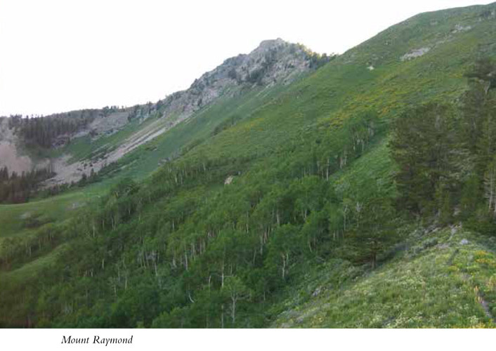
The hike to Mount Raymond via Butler Fork provides a rich selection of eye candy and experiences: lush aspen forests, open views up Big Cottonwood Canyon, fun rock scrambling, 360-degree summit views, and the challenge of a vertical climb combined with strolling through an aspen grove. It’s a winning combination that takes you to a 10,241-foot peak. In fall the aspens spread gold across the canyon, and during summer’s wildflower season Mount Raymond is dotted with color.
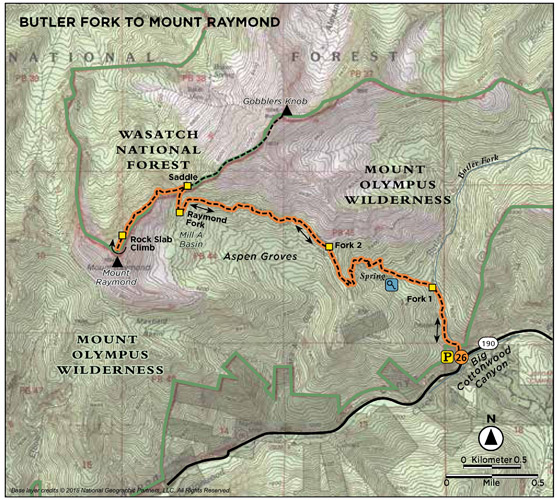
Start: Butler Fork trailhead
Distance: 7.8 miles out and back
Hiking time: About 4.5 hours
Difficulty: Strenuous
Elevation gain: 3,100 feet
Trail surface: Dirt and rock path
Best season: Summer and fall
Other trail users: None
Canine compatibility: Dogs prohibited
Land status: Uinta-Wasatch-Cache National Forest; Walter F. Mueggler–Butler Fork Natural Research Area; Mount Olympus Wilderness Area
Nearest town: Brighton
Fees and permits: No fees or permits required
Maps: USGS Mount Aire
Trail contacts: Salt Lake County Parks and Recreation, (385) 468-1800; Salt Lake Ranger District, 6944 South 3000 East, Salt Lake City 84121; Uinta-Wasatch-Cache National Forest, 8236 Federal Building, 125 South State St., Salt Lake City 84138
Finding the trailhead: From Salt Lake City take I-215 south to 6200 South (exit 6). Turn left (east) off the exit and continue for 1.7 miles (6200 South becomes Wasatch Boulevard) to the mouth of Big Cottonwood Canyon (UT 190). Turn left at the signal onto UT 190 and drive 8.2 miles up Big Cottonwood Canyon to the small parking area and trailhead on the left side of the road. GPS: N40 38.963' / W111 39.707'
The Hike
Mount Raymond is one of the most prominent peaks on the north side of Big Cottonwood Canyon. The well-defined trail runs through a protected area called the Walter Mueggler–Butler Fork Natural Research Area. The area serves as a high-quality control area for the study of natural ecological processes. It was established here in the Butler Fork drainage because although most of Utah’s aspen stands have experienced moderate to heavy impacts from mining, logging, and cattle, this drainage has been excluded from such invasions for more than one hundred years. The aspen communities in this 1,270-acre natural research area are as pristine as can be found in this region. Butler Fork was named for the Butler brothers, who established a steam sawmill in the fork in 1877.
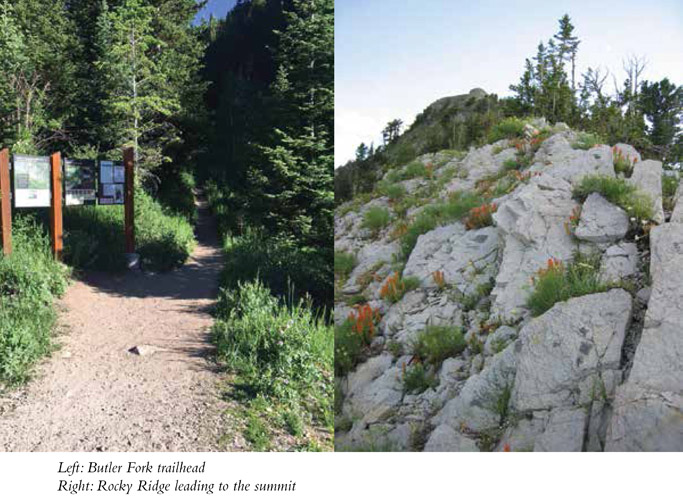
The trail begins next to a stream as it heads up the Butler Fork drainage, and as you cross the stream on wooden bridges and low water areas, the stream moves from the right to the left side of the trail. Nice tall evergreens and a spattering of the quaking aspens you will see farther up the trail shade some sections, while other sections of the trail open up to the sun.
The trail enters the Mount Olympus Wilderness Area at 0.4 mile and you reach the first signed intersection at 0.5 mile. Head toward Mill A Basin whenever the trail signs give you the option. The stream continues for the first 0.75 mile of the trail, and at 1.3 miles you break out of the trees and gain a view down Butler Fork and Big Cottonwood Canyon.
At 1.7 miles you get your first good look to the west at the big rocky slab face of Mount Raymond. You also get your first look at some of Big Cottonwood’s tallest peaks across the canyon on the south side. Twin Peaks (11,302 feet) sits to the west; Sundial Peak (10,282 feet) sits to the south. This is a nice vantage point for locating and identifying the peaks and drainages that surround you.
At 1.9 miles you enter the aspen groves that stretch across Mill A Basin, and the climb slows to a stroll through the beautiful, colorful aspen. A few hundred feet later a trail junction points you left toward Mill A Basin or right to Dog Lake. Head toward Mill A Basin.
At 2.2 miles the view opens to the south. The two peaks on the far west are Twin Peaks, the peak east of this is Dromedary, the next peak is Sunrise, and the peak that is covered with trees and sitting in the forefront is Mount Kessler. From here the trail continues to scoot through the aspen. At 3.0 miles you come to the first unmarked trail junction. The left fork heads down past the foot of Mount Raymond into Mill A Basin; the right fork goes up to the Baker Pass saddle between Mount Raymond and Gobblers Knob. Take the right fork and climb out of the trees to the saddle. Here, above the tree line, the trail heads along the ridge to the southwest and the trail becomes a stairway of crumbly limestone and quartzite. The trail follows steeply along the ridge and winds down to the west side a bit as it makes its way up to the summit. From the saddle to the top you have expansive views the entire 0.7 mile.
As you get closer to the summit, the rock piles become larger and the trail becomes less defined. You can see the summit, so you know the direction you are heading, but the last 0.2 mile is all rock scrambling to make it to the summit. At 3.8 miles you’ll have to climb up a sheer striated rock slab to continue. The thin trail picks up again as it weaves through the rock piles to the top.
The Mount Raymond summit is a pile of rocks from which you have 360-degree views west over the Salt Lake Valley, Kennecott Copper mine, and the Great Salt Lake. To the north lies Mill Creek Canyon. For those familiar with the stark steepness of Little Cottonwood Canyon, this vantage point accentuates the difference between the two canyons as you note the rolling nature of Big Cottonwood Canyon to the east. A USGS marker marks the summit. Return the way you came.
Miles and Directions
0.0 Start at the Butler Fork trailhead.
400 feet Come to a bridge crossing.
0.4 Enter Mount Olympus Wilderness Area.
0.5 Reach the first trail intersection; continue toward Mill A Basin.
1.3 The trail breaks from the trees for views down Butler Fork.
1.7 Enjoy your first sighting of Mount Raymond.
1.9 Enter the aspen groves.
1.95 Come to the second trail intersection; head left toward Mill A Basin.
2.2 The view to the south opens for a ridgeline view of the south side of Big Cottonwood Canyon.
3.0 Come to an unmarked trail intersection; head right to climb to the saddle.
3.2 Arrive at the saddle of Baker Pass.
3.8 Come to a rock slab that must be climbed.
3.9 Arrive at the summit of Mount Raymond. Retrace your steps to the trailhead.
7.8 Arrive back at the trailhead.
Option
From the saddle at Baker Pass you can head northeast and take in the hike to Gobblers Knob, which is only 5 feet higher than Mount Raymond. This route climbs 900 feet in 0.8 mile for a total out-and-back hike of 8 miles. Many hikers will hit both peaks in 1 day.
Hike Information
Camping: The Salt Lake Ranger District manages three campgrounds up Big Cottonwood Canyon (UT 190): Jordan Pines, Spruces, and Redman. Jordan Pines is located 8.8 miles up Big Cottonwood Canyon. To reach the campground turn right onto Cardiff Fork Road across from the Mill D trailhead. The entrance is 0.25 mile from Big Cottonwood Road (UT 190). Camping at Jordan Pines is by reservation only, and the campground is well suited for groups. Spruces Campground, the largest campground in the Salt Lake Ranger District, is 9.7 miles up Big Cottonwood Canyon. It has ninety-seven campsites with tables, grills, and fire circles. Redman Campground is 13 miles up Big Cottonwood Canyon and has forty-three campsites. There are no RV hookups, and most sites are first-come, first-served.
Camping is permitted in designated campgrounds only. For reservations call the National Recreation Reservation Service at (877) 444-6777 or go to www.reserveusa.com.
EDIBLE WILD PLANTS OF UTAH
Have you ever wondered what you might do if you were lost in the woods, you forgot the GORP, and an emergency situation arose? Fortunately Utah is full of edible plants. You must be careful to understand which wild plants can be eaten, as many are poisonous, but here are a few easy-to-identify plants that are safe for consumption:
Wild raspberry: Found in sunny places near lakes, streams, and often roads, the plant looks like a regular raspberry bush and the fruit is easy to recognize. Not only can you eat the fruit but the young stems also can be peeled and eaten.
Dandelion: An infamous weed seen in many a lawn, the dandelion can be found throughout Utah’s mountains as well. The good news is that the entire plant is edible: Leaves can be eaten raw or boiled, and the roots can be boiled or roasted. The seeds of the plant are also edible and can even be ground into flour.
Clover: You’re in luck—clovers are actually edible. And they’re found just about everywhere there’s an open grassy area. You can spot them by their distinctive trefoil leaflets. You can eat clovers raw or boil it.
Donut Falls is a popular, fun, family-friendly hike. With a destination involving the unusual phenomenon of a waterfall cascading through a round hole in the rock surface, it’s bound to draw the crowds it does. The trail is under 1.0 mile and easy to follow, but once you arrive there is the challenge of carefully making your way up the stack of boulders that make up the mountain below the falls. An original destination, a little challenge—and all on a trail that can be enjoyed in an hour.
Start: Mill D South Fork Upper/Donut Falls trailhead
Distance: 1.8 miles out and back
Hiking time: About 1 hour
Difficulty: Moderate due to rock scramble to reach the falls
Elevation gain: 320 feet
Trail surface: Dirt and rock; boulder climbing at the falls
Best season: Late spring through fall; snowshoes advised in winter
Other trail users: None
Canine compatibility: Dogs prohibited
Land status: Uinta-Wasatch-Cache National Forest
Nearest town: Brighton
Fees and permits: No fees or permits required
Schedule: Open daily 7 a.m. to 10 p.m.
Maps: USGS Mount Aire
Trail contacts: Salt Lake County Parks and Recreation, (385) 468-1800; Salt Lake Ranger District, 6944 South 3000 East, Salt Lake City 84121, (801) 733-2660; Uinta-Wasatch-Cache National Forest, 8236 Federal Building, 125 South State St., Salt Lake City 84138
Other: Suggested footwear is a water sandal with a good traction sole. This trail is so popular that often the parking lot fills and cars are forced to park down the sides of the road and hike to the trailhead. This is more the rule than the exception. Plan accordingly as it can tack on another 0.25-mile hike at times.
Finding the trailhead: From Salt Lake City take I-215 south to 6200 South (exit 6). Turn east off the exit and continue along 6200 South (changes to Wasatch Boulevard) for 1.7 miles to the mouth of Big Cottonwood Canyon (UT 190). Turn left (east) at the signal and travel 9 miles up the canyon to the Mill D trailhead. Across the road from Mill D, on the south side of the canyon, is another road (Mill D South) that heads to Jordan Pines Campground. Follow this road for 0.7 mile to the Mill D South Fork Upper/Donut Falls trailhead. The trailhead has parking for fifteen cars; extra vehicles can park along the roadside. Restrooms are available at the trailhead. GPS: N40 38.369' / W111 39.077'
Three major physiographic provinces are found within the state of Utah: the Rocky Mountain Province, the Great Basin Province, and the Colorado Plateau.
The Hike
Donut Falls was named for the hole in the rock through which water cascades into an alcove reached by climbing up the rocky mountain face below the falls and ducking under an arch into a grotto. The splash of the water is cool and refreshing, and the site is certainly different from the usual open waterfall.
Closed to public access between 2004 and 2006, the Donut Falls was purchased by Salt Lake County in 2007 and reopened to the public. The trail begins on the south side of the parking lot to the west of the restrooms along a well-worn dirt doubletrack that climbs past spruce, fir, aspen, and pine. The trail is easy to follow and well marked with small sign markers along the route.
At 0.5 mile you come to a nice grove of trees and a bridge crossing the stream. Directly on the other side of the bridge, the trail intersects an old gravel jeep road. Turn left onto this road and follow it south. You’ll quickly see a small trail that heads to the right, but stay on the main gravel trail. A short distance farther you will reach a small rock face that must be climbed down to reach the creek. Children and less-agile hikers may need help making their way down this section.
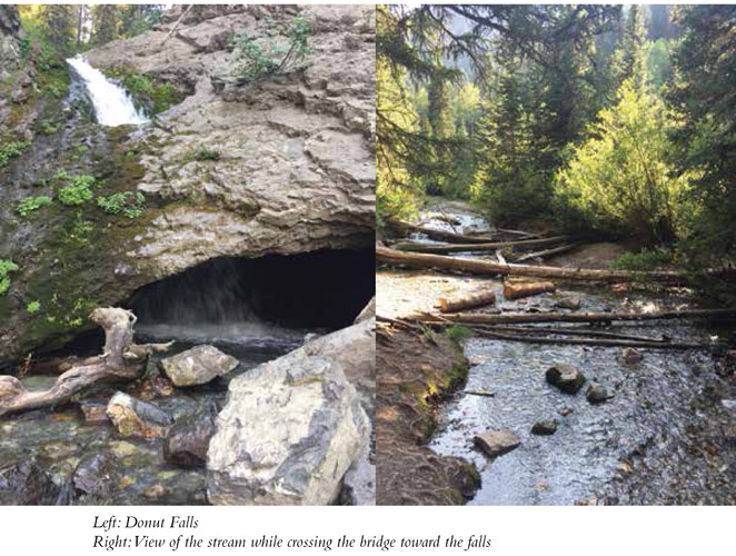
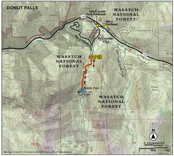
After the descent the trail follows the stream to the base of the rocky mountain face the water flows down. To view the falls, these rocks must be navigated to the top. Exercise extreme caution while climbing these rocks. Water flow is heavier during spring runoff or right after a storm. Return following the same route.
Miles and Directions
0.0 Start at the Mill D South Fork Upper/Donut Falls trailhead.
0.5 Come to a bridge crossing; turn left onto an open gravel jeep road.
0.6 The trail forks; bear left.
0.7 Come to the short rock face you must scale down to get creekside.
0.8 Arrive at the base of the rock mountain below the falls. Scramble across the stream and up the rocks to Donut Falls.
0.9 Arrive at the waterfall crashing through the hole in the rock. Return the way you came.
1.8 Arrive back at the trailhead.
Hike Information
Camping: The Salt Lake Ranger District manages three campgrounds up Big Cottonwood Canyon (UT 190): Jordan Pines, Spruces, and Redman. Jordan Pines is located 8.8 miles up Big Cottonwood Canyon. To reach the campground turn right onto Cardiff Fork Road across from the Mill D trailhead. The entrance is 0.25 mile from Big Cottonwood Road (UT 190). Camping at Jordan Pines is by reservation only, and the campground is well suited for groups. Spruces Campground, the largest campground in the Salt Lake Ranger District, is 9.7 miles up Big Cottonwood Canyon. It has ninety-seven campsites with tables, grills, and fire circles. Redman Campground is 13 miles up Big Cottonwood Canyon and has forty-three campsites. There are no RV hookups, and most sites are first-come, first-served.
Camping is permitted in designated campgrounds only. For reservations call the National Recreation Reservation Service at (877) 444-6777 or go to www.reserveusa.com.
Big and Little Cottonwood Canyons were named for the giant cottonwood trees that grow by the creek bottoms.
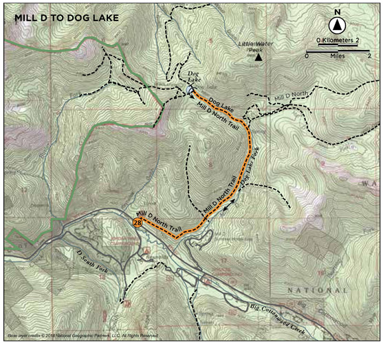
Whether it’s summer, fall, or winter, the trail to Dog Lake from Mill D trailhead is filled with beautiful scenery. Views cross-canyon are a treat on the first section of the trail, while the destination is a small mountain lake where dogs frolic and hikers and bikers relax after making their way in from either Mill Creek Canyon (the only way you can bring dogs in) or Big Cottonwood Canyon. Surrounded by aspen trees and evergreens, fall is a colorful time at the lake.
Start: Mill D Trailhead
Distance: 5.2 miles out and back
Hiking time: About 2.5 hours
Elevation gain: 1,500 feet
Trail surface: Dirt and rock
Best season: Summer and fall
Other trail users Bikers
Canine compatibility: Not allowed
Land status: US Forest Service
Nearest town: Brighton
Fees and permits: No fees or permits required
Maps: USGS 7.5' Mount Aire
Trail contacts: For more information contact Salt Lake County Parks and Recreation, (385) 468-1800
Special considerations: Wading, boating, horses, and dogs are all prohibited in watershed area. While dogs are allowed at Dog Lake, they can only be brought in through Mill Creek Canyon. No dogs or domestic animals are allowed in Big Cottonwood Canyon. Toilets are not available at Mill D, but you can find a restroom across the road on Cardiff Canyon Road.
Finding the trailhead: From Salt Lake City take I-215 south to 6200 South (exit 6). Turn east off the exit and continue along 6200 South (changes to Wasatch Boulevard) for 1.7 miles to the mouth of Big Cottonwood Canyon (UT 190). Turn left (east) at the signal and travel 9 miles up the canyon to the Mill D trailhead. Mill D is on the north side of the canyon; the turnoff for Donut Falls is on the south side across the road.
There is a large park-and-ride at the mouth of Big Cottonwood Canyon. During peak times it will be best to carpool to the trailhead as it is popular and often crowded.
The Hike
Mill D trailhead is one of the largest and most recognized trailheads in Big Cotton Canyon. Sitting right off the side of the main thoroughfare up the canyon, a prominent trailhead sign and parking on the north side of the road make the trailhead hard to miss. The trail is easy to follow as it is a favorite and well-worn path that leads to two destinations: Dog Lake and Desolation Lake. The first section of the trail is open to the sun because of the southern exposure; then it rounds the bend of the mountain and heads north deeper into the range.
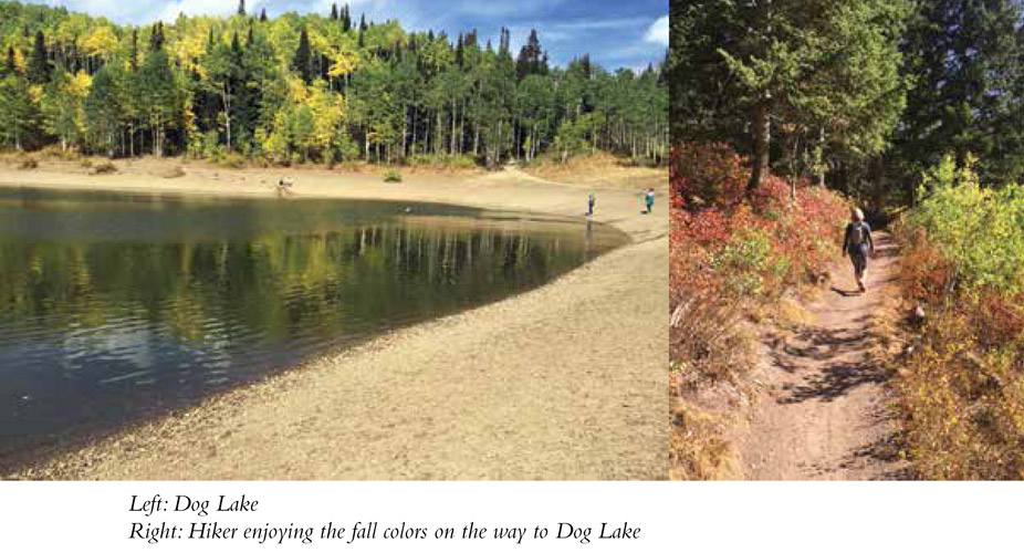
From the trailhead the trail heads into the mountains and curves to the right heading upcanyon. The southern exposure provides phenomenal views cross-canyon to the beautiful mountains on the other side of the road. At 0.3 mile the trail enters a Lord of the Rings–esque clearing with rocks, moss, and tall thick trees. This sheltered and beautiful space houses the trail for 0.2 mile. At 0.5 mile the trail rounds the corner of the mountain and the view opens again as it heads north. Take time to enjoy the view upcanyon to the east. At 1.4 miles a small stream sidles up to the trail. The trail parallels the creek off-and-on as it heads north. At 2 miles the trail forks for Desolation and Dog Lake. Signage shows that Dog Lake hikers must head to the left. From here the trail is a steady climb of 0.6 mile up to the lake. At the top of the climb you will find Dog Lake. Other trails lead around the lake on both sides. You can see the wide trail on the northwest corner of the lake that comes in from Mill Creek Canyon. When you are finished enjoying your time at the lake, return the way you came.
Miles and Directions
0.0 Mill D Trailhead.
0.3 Lord of the Rings–esque clearing.
0.5 Trail rounds corner.
1.4 Trail parallels stream.
2.0 Trail forks for Desolation and Dog Lake—head left.
2.6 Reach Dog Lake; return the way you came.
5.2 Arrive back at the trailhead.
Big Cottonwood Canyon and Little Cottonwood Canyon contain significant biodiversity and are home to a number of rare plant species. The Wasatch shooting star is one example.
Hike Information
Camping: The Salt Lake Ranger District manages three campgrounds up Big Cottonwood Canyon (UT 190): Jordan Pines, Spruces, and Redman. Jordan Pines is located 8.8 miles up Big Cottonwood Canyon. To reach the campground turn right onto Cardiff Fork Road across from the Mill D trailhead. The entrance is 0.25 mile from Big Cottonwood Road (UT 190). Camping at Jordan Pines is by reservation only, and the campground is well suited for groups. Spruces Campground, the largest campground in the Salt Lake Ranger District, is 9.7 miles up Big Cottonwood Canyon. It has ninety-seven campsites with tables, grills, and fire circles. Redman Campground is 13 miles up Big Cottonwood Canyon and has forty-three campsites. There are no RV hookups, and most sites are first-come, first-served.
Camping is permitted in designated campgrounds only. For reservations call the National Recreation Reservation Service at (877) 444-6777 or go to www.reserveusa.com.
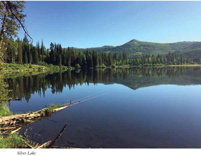
Silver Lake has been the heart of the upper Big Cottonwood area since early pioneer days. Originally called “Plesant [sic] Lake” by a pioneer scout, it has gone through several names, including Fish Lake when pioneers discovered the abundant fishing. This hike begins at what is now the Silver Lake Interpretive Trail—a 1.0-mile-long boardwalk that circles Silver Lake and provides informational signs describing the surrounding ecosystem. This is a favorite family spot, and weekends are generally crowded. From here the route climbs to Lake Solitude, which provides just the opposite of Silver Lake—most likely no more company than a few ducks floating on the pond. To round out the adventure the trail then climbs to Twin Lakes, a large, beautiful blue lake sitting in one of the many granite cirques of these high mountains. Mountain lakes are a refuge for people and animals alike, and though you will find fewer folks here than at Silver Lake, chances are good that a group or two will be enjoying the dazzling show of sun on water. The trail offers the wonders of quaking aspen, wildflowers, mountain lakes, and peaceful evergreen stands.
Start: Silver Lake Interpretive trailhead
Distance: 5.4 miles out and back
Hiking time: About 3 hours
Difficulty: Moderate due to some climbing
Elevation gain: 710 feet
Trail surface: Boardwalk, dirt and rock path
Best season: Summer and fall
Other trail users Mountain bikers on Solitude ski resort
Canine compatibility: Dogs prohibited (Big Cottonwood Canyon is a watershed.)
Land status: National forest, federal land, Solitude ski resort easement, private mining claims, Salt Lake City land
Nearest town: Brighton
Fees and permits: No fees or permits required
Schedule: Silver Lake Nature Center: The hours change each season according to employee availability. Trail is always open.
Maps: USGS Brighton
Trail contacts: Uinta-Wasatch-Cache National Forest, 3285 East 3300 South, Salt Lake City 84109; Silver Lake Nature Center/Solitude Nordic Center, (801) 536-5774
Special considerations: No wading, swimming, or dogs are permitted in Big Cottonwood Canyon due to its watershed status. Overnight camping is not allowed in the Silver Lake area. Backcountry camping must be at least 200 feet from any water source. Picnic tables can be found around the Silver Lake Nature Center for lunch at the lake. Moose are often sighted around the Silver Lake area. Remember to respect wildlife and keep your distance.
Other: The nature center also serves as the Solitude Nordic Center in winter.
Finding the trailhead: From Salt Lake City take I-15 south. Merge onto I-215 east via exit 298. Follow I-215 for 5.5 miles to UT 190/6200 South exit 6 toward the ski areas. Head east off the exit and follow the road for just under 2 miles to the mouth of Big Cottonwood Canyon Road/UT 190. Follow UT 190 for 15 miles up the canyon to Brighton ski resort. The Silver Lake Recreation Area and parking are on your right as you first enter the Brighton Loop. The trail begins behind the visitor center on the northwest side of the building. GPS: N40 36.203' / W111 35.074'
The Hike
Mount Evergreen towers over Silver Lake and the boardwalk below. The trail begins on the Silver Lake Interpretive Trail boardwalk heading to the northwest corner of Silver Lake. Willow, wild rose, and other plants line the pathway. Anglers enjoy casting a line along the boardwalk, and families enjoy exploring the wetland without getting wet.
At the northwest corner of Silver Lake, a large trail sign indicates where the trail exits the boardwalk (0.3 mile) to get to Lake Solitude and Twin Lakes. The path is an easy dirt trail that heads into large groves of aspen.
The next fork in the trail (0.4 mile) divides the routes to Solitude and Twin Lakes. The right fork, or path forward, leads toward Solitude Lake, the left, uphill, toward Twin Lakes. Take the right fork. If you choose the loop return option, you will be descending down this left fork.
The trail climbs through a thick cover of aspen and fir into the Solitude ski resort. The ski resort offers lift-assisted mountain biking on summer and fall weekends, so be prepared to share the trail with the occasional mountain biker. The trail meanders through the forest and offers plenty of shade, fresh fragrance, and eye candy. At 0.8 mile a number of trails converge on the path. Cut straight across and continue on the middle trail across the mountain. The path crosses beneath Solitude’s Sunrise ski lift. Follow the signs to Solitude Lake. The trail is well marked for the mountain bikers and will take you directly to Lake Solitude.
Lake Solitude is aptly named. The shallow lake lies secluded among willows, pines, granite, and mine tailings. The lake is more of a swampy pond that attracts ducks and other waterfowl, unless it’s a high water year. It fluctuates with the runoff. Lake Solitude is at the head of Mill F South Fork and was originally called Lizard Lake by pioneers because salamanders were found in many Wasatch lakes. On the far south side of the lake, an old mine shaft—the Solitude Tunnel—has been filled in with rock. You can’t enter the shaft, but if you stand next to it you can feel the cold air rushing out of the earth. Some affectionately call this spot the “air conditioner.” To find it, go to the far southwest corner of the lake and look right against the cliff wall (GPS: N40 36.207' / W111 36.107').
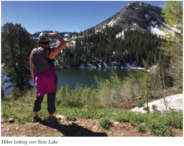
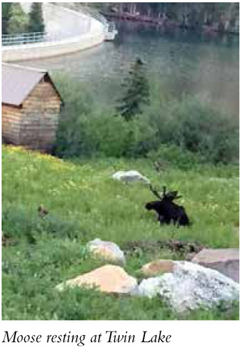
The trail continues on the dirt road on the other side of the lake as it climbs up the mountain to Twin Lakes overlook. At 2.5 miles, an overlook juts out to the right, providing a wonderful view of Twin Lakes sitting serenely in Wolverine Cirque. Descend to Twin Lakes by taking the trail to the east and enjoy your time on the shore. Twin Lakes sit at 9,472 feet elevation. The site originally held two lakes. They were combined in 1915 when Twin Lakes reservoir and dam was built.
Miles and Directions
0.0 Start at the trailhead for the Silver Lake Interpretive Trail.
0.3 Exit the Silver Lake Interpretive Trail onto a packed-dirt trail heading west into the forest. This is also the trailhead for Lake Solitude and Twin Lakes.
0.4 Come to the trail junction for Twin Lakes and Lake Solitude; take the right fork.
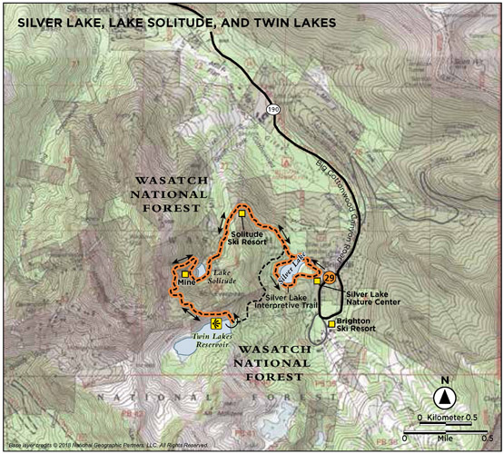
0.8 Head forward on the middle trail.
1.7 Reach Lake Solitude.
2.5 Come to an overlook with a view of Twin Lakes.
2.7 Reach Twin Lakes. Return the way you came or take the loop option and head back to Silver Lake (4-mile loop).
5.4 Arrive back at the Silver Lake Nature Center.
Option
To make this a loop hike, rather than turning around at Twin Lakes, head down below the dam on the east side of the lake. The Twin Lakes Trail enters from the northeast (GPS: N40 35.932' / W111 35.714'). Follow the trail marked “Easy Out.” From here to Silver Lake is 1.3 miles. When you return to Silver Lake, take a right and continue around the rest of the boardwalk to enjoy the full Silver Lake palette.
Wasatch is a Ute word meaning “low place in high mountains.”
Hike Information
Camping: The Salt Lake Ranger District manages three campgrounds up Big Cottonwood Canyon (UT 190): Jordan Pines, Spruces, and Redman. Jordan Pines is located 8.8 miles up Big Cottonwood Canyon. To reach the campground turn right onto Cardiff Fork Road across from the Mill D trailhead. The entrance is 0.25 mile from Big Cottonwood Road (UT 190). Camping at Jordan Pines is by reservation only, and the campground is well suited for groups. Spruces Campground, the largest campground in the Salt Lake Ranger District, is 9.7 miles up Big Cottonwood Canyon. It has ninety-seven campsites with tables, grills, and fire circles. Redman Campground is 13 miles up Big Cottonwood Canyon and has forty-three campsites. There are no RV hookups, and most sites are first-come, first-served.
Camping is permitted in designated campgrounds only. For reservations call the National Recreation Reservation Service at (877) 444-6777 or go to www.reserveusa.com.