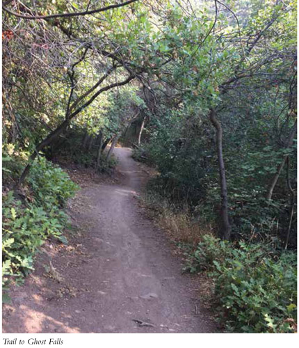
Ghost Falls can be accessed from every trailhead in the Corner Canyon system of linking trails, but when approached from the Ghost Falls trailhead, the hike is a pleasant downhill stroll, complete with shade, gurgling springs, and seasonal wildflowers. Short and sweet, with a scenic waterfall at the end, this trail is perfect as a family hike with youngsters or just a quick forested getaway.
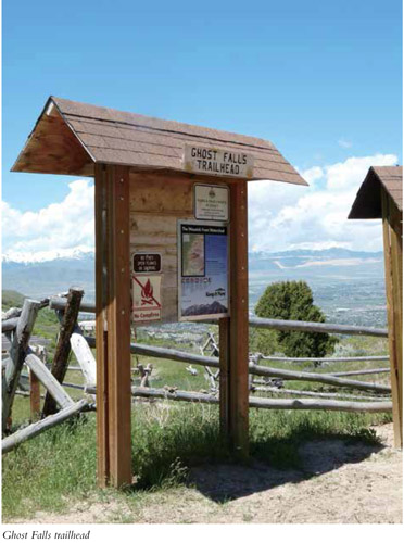
Start: Ghost Falls trailhead
Distance: 1.5 miles out and back
Hiking time: About 45 minutes
Difficulty: Easy
Elevation gain: 250 feet
Trail surface: Dirt path and bridge
Best season: Spring through fall
Other trail users: Mountain bikers
Canine compatibility: Dogs prohibited (watershed area)
Land status: Regional park owned by Draper City
Nearest town: Draper
Fees and permits: No fees or permits required
Schedule: Park hours 6 a.m. to 10 p.m. The road to Ghost Falls trailhead is gated off during winter and remains closed while any snow remains.
Maps: Draper City trails map available at www.draper.ut.us/116/Trails-Open-Space, or in the Draper City Office at 1020 E. Pioneer Rd., Draper
Trail contacts: Draper City Parks and Recreation, 1020 East Pioneer Rd., Draper 84020; (801) 576-6500
Special considerations: Beware of poison ivy by the falls.
Finding the trailhead: From Salt Lake City head south on I-15 to the Bangerter exit 289 near Point of the Mountain. Head east off the exit and turn left in 0.5 mile at the second light onto 13800 South. Follow 13800 South for 1.7 miles to 1300 East. Turn right and go under South Mountain Bridge. On the other side of the bridge, turn left and continue 1.4 miles to a right turn into the Orson Smith trailhead. From here follow a dirt road for 2.6 miles to Ghost Falls trailhead. A high-clearance or four-wheel-drive vehicle is needed. GPS: N40 29.665' / W111 49.033'
The Hike
Ghost Falls is so named because no one knows where the water comes from. Natural springs in the mountain apparently spring to the surface and form the falls. The Draper City Parks Department and volunteers have turned what was once an old horse trail into a curvaceous, winding trail that runs beneath shady maples and scrub oak, dotted in spring with wildflowers. The trail is perfect for a hike with children—it is short and nicely shaded and ends at a beautiful waterfall.
Picnic tables, a pit toilet, and a trail kiosk are located at the trailhead. Right after you pass the picnic tables, the trail heads both up and down the canyon. The trail to the left (east) hooks in with Jacob’s Ladder, while the trail that heads right and downhill takes you to Ghost Falls. This trail is different from most in the Wasatch in that you descend to your destination and then ascend on the way out. All trails have no more than a 10 percent grade, so the uphill remains pleasant and easy.
Nice springs and streams can be heard as you descend, but often you won’t be able to see the water. Wild rose, wild onion, horsemint, and too many other wildflowers to name dot the landscape.
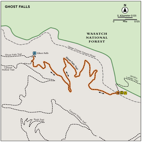
Just before the falls the trail hits a T junction (0.7 mile); you can see and hear the falls from here. Turn right to reach the waterfall at 0.75 mile. A Boy Scout cleared the area around the waterfall as an Eagle Scout project, and most of the plants and poison ivy have been cut away to provide a nice clear area for sitting on rocks and enjoying the falls or taking photos. Return the way you came.
Miles and Directions
0.0 Start at the Ghost Falls trailhead.
0.7 Come to a T intersection; head right to reach the falls.
0.75 Arrive at Ghost Falls. Return the way you came.
1.5 Arrive back at the trailhead.
As of 2017 there are 60 miles of trails in the Corner Canyon area, and more are being developed.
Hike Information
Local events and attractions: Draper City sponsors trail runs and bike races along the Corner Canyon trails.
Supplies/equipment: Recreational Equipment Inc. (REI), 230 West 10600 South, Ste. 1700, Sandy 84070; (801) 501-0850
GREEN TIP
Throw a plastic bag in your pack so you can haul out toilet paper.
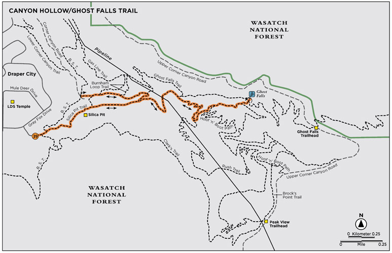
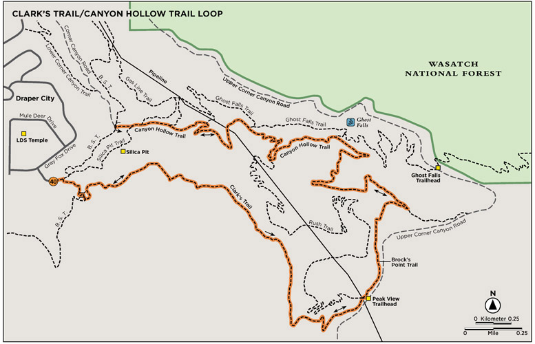
This trail climbs the main canyon, parallel to Corner Canyon Creek, up to Ghost Falls. Intermixed with shaded singletrack, gravel road, and riverside travel, there is also a trail option that allows you to make the hike a lollipop. Ghost Falls, so named because no one is certain where the water comes from, is a beautiful cooling station and a highlight of the Corner Canyon trail system. Because the Corner Canyon trails sit at a lower elevation, the snow melts off these trails earlier than most and they are some of the first to be accessed in spring. This trail takes the Canyon Hollow Trail to Ghost Falls.
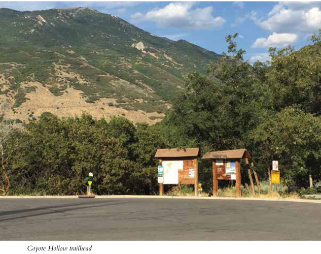
Start: Coyote Hollow trailhead
Distance: 2.8 miles out and back or 2.8-mile lollipop
Hiking time: 1.5–2 hours
Difficulty: Easy
Elevation gain: 280 feet
Trail surface: Dirt, gravel road, bridge
Best season: Spring through fall
Other trail users Mountain bikers, horses
Canine compatibility: Dogs prohibited, watershed area
Land status: Regional park owned by Draper City
Nearest town: Draper
Fees and permits: No fees or permits required
Schedule: Park hours 6 a.m. to 10 p.m.
Maps: Trail maps are available at www.draper.ut.us/116/Trails-Open-Space or in the Draper City Office, 1020 E. Pioneer Road, Draper.
Trail contacts: Draper City Parks and Recreation, 1020 East Pioneer Rd., Draper 84020; (801) 576-6500
Special considerations: These trails are very popular with mountain bikers. Prepare to share the trails and be on the lookout for fast downhill riders.
Finding the trailhead: Coyote Hollow trailhead sits directly behind the LDS Draper temple. From Salt Lake City head south on I-15. Take the Bangerter exit 289 near the Point of the Mountain. Head east off the exit and turn left 0.5 mile later at the second light onto 13800 South. Follow 13800 South for 1.7 miles to 1300 East. Turn right and go under the South Mountain Bridge. Take a right on the other side of the bridge and go to Rambling Road/1220 East. Turn left onto Rambling Road/1220 East and follow the signs to the LDS Draper temple. When you get to Pinon Hill Lane, turn left and then take your first right then your first left down Gray Fox Drive. Coyote Hollow Court is your first right after that. The trailhead sits at the bottom of the circle. There are no restrooms. GPS: N40 29.606' / W111 50.344' For additional parking you can park at Red Rock trailhead, just west of Coyote Hollow on Mike Weir Drive across from South Mountain Golf Course. You can follow the Bonneville Shoreline Trail back to Coyote Hollow.
The Hike
Coyote Hollow is Corner Canyon’s most popular trailhead. The land that is now Corner Canyon Regional Park was purchased by Draper City in 2005 to protect the land and watershed from the massive residential development taking place in the Draper foothills. The park’s 1,021 acres are in the process of continued development, and pristine mountain trails continue to be added per the master plan. In 2012, 2,400 more acres of land were purchased by Draper City to continue with Corner Canyon trail development. Their master plan was redone in 2016. This trail system is open to all nonmotorized use, so everyone works together to be respectful to a variety of users as well as to the land.
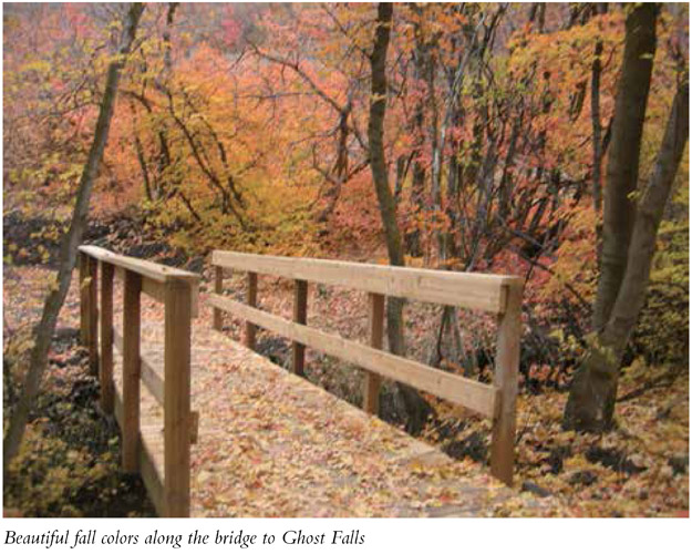
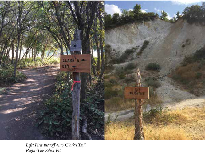
Head east out of Coyote Hollow trailhead—365 feet later there is an intersection where the Canyon Hollow Trail and the Silica Pit go to the right and the Bonneville Shoreline Trail goes to the left. Follow the sign to the right staying on the Canyon Hollow Trail. At 0.13 mile the trail splits. Head right again toward the Silica Pit. At 0.3 mile you reach the Silica Pit. Cross through it. At 0.5 mile the Rush Trail, a downhill mountain bike trail, crosses the Canyon Hollow Trail. Watch for fast-moving bikes. Stay on the trail marked Canyon Hollow. At 0.6 mile the trail splits again. Continue straight ahead taking the right fork. A scenic view opens at 0.8 mile where the trees open up providing a view of the LDS Temple with its tall spire, the surrounding neighborhoods, and part of the valley below. At 0.85 mile the Hoof and Boot Trail, a foot traffic and horse-only trail, intersects from the right. At this point the trail opens up to a doubletrack dirt road for a hundred feet. Head up the road and follow the signs to Canyon Hollow. At 1 mile the Canyon Hollow trail comes to a T. Turning right will simply loop back around and take you back down to hook into the Canyon Hollow Trail down below. Turn left and continue up the canyon instead. At 1.06 miles the Hoof and Boot Trail intersects again from the right. The trail then crosses a bridge and at 1.25 the Hoof and Boot Trail intersects from the left. This foot and horse path crosses the Canyon Hollow Trail four times along this route. At 1.3 miles leave the Canyon Hollow Trail and head left toward Ghost Falls. In the next tenth of a mile you will cross two bridges. When you come to the third bridge you are at Ghost Falls (at the 1.4-mile mark). Enjoy the stream, the waterfall, and the rocks around the area that provide a place to sit and rest, picnic, or just enjoy the scenery. Return the way you came for a 2.8-mile round-trip hike.
Miles and Directions
0.0 Start at the Coyote Hollow trailhead.
365 feet Trail splits for Canyon Hollow and the Silica Pit.
0.13 Trail splits. Go left to continue toward the Silica Pit.
0.3 Trail crosses the Silica Pit.
0.6 Trail splits—continue straight ahead.
0.8 Trail opens up for a scenic view.
1.0 Trail comes to an intersection. Lead left and continue up the canyon.
1.3 Leave the Canyon Hollow Trail and take a left onto the Ghost Falls Trail.
1.4 Arrive at Ghost Falls. Return the way you came or take the lollipop option.
2.8 Arrive back at the trailhead.
Option
The Canyon Hollow to Ghost Falls hike can also be done as a lollipop. Instead of returning on Canyon Hollow trail, cross the bridge at the foot of the falls and continue on the Ghost Falls trail that heads west. The Ghost Falls trail is rockier and has less shade, but it allows for different scenery.
Hike Information
Local events and attractions: Draper City sponsors trail runs and bike races along the Corner Canyon trails.
Supplies/equipment: Recreational Equipment Inc. (REI), 230 West 10600 South, Ste. 1700, Sandy 84070; (801) 501-0850
Clark’s Trail is a beautiful hike up the mountain to the Peak View trailhead. Shaded trails occasionally open up to full, rich views of the surrounding Draper neighborhoods and expand to the Wasatch Front, Kennecott Copper across the valley, and down into Corner Canyon. A great combination of a beautiful shaded trail with panoramic views, you’ll love this trail any time of day. It is the longest and prettiest loop in the park. As Clark’s Trail tops out at Peak View trailhead, it cuts across to Brock’s Point Trail and then hooks into Canyon Hollow Trail farther downcanyon for a nice loop around the Corner Canyon area. Just steps from a Draper neighborhood, the trail is easy to access.
Start: Coyote Hollow trailhead
Distance: 4.3-mile loop
Hiking time: About 3 hours
Difficulty: Moderate
Elevation gain: 670 feet
Trail surface: Packed dirt and gravel road
Best season: Spring through fall. Snow melts off the Corner Canyon trails earlier than most in the Salt Lake City area because the trail system sits at a lower elevation right next to town.
Other trail users: Mountain bikers (allowed uphill only on Clark’s Trail but prevalent elsewhere), horses
Canine compatibility: Dogs prohibited, watershed area
Land status: Regional park owned by Draper City
Nearest town: Draper
Fees and permits: No fees or permits required
Schedule: Park hours 6 a.m. to 10 p.m.
Maps: Trail maps are available at www.draper.ut.us/116/Trails-Open-Space, or in the Draper City Office, 1020 E. Pioneer Rd., Draper.
Trail contacts: Draper City Parks and Recreation, 1020 East Pioneer Rd., Draper 84020; (801) 576-6500
Special considerations: These trails are very popular with mountain bikers. Prepare to share the trails, and be on the lookout for fast downhill riders.
Finding the trailhead: Coyote Hollow trailhead sits directly behind the LDS Draper temple. From Salt Lake City head south on I-15. Take the Bangerter exit 289 near the Point of the Mountain. Head east off the exit and turn left 0.5 mile later at the second light onto 13800 South. Follow 13800 South for 1.7 miles to 1300 East. Turn right and go under the South Mountain Bridge. Take a right on the other side of the bridge and go to Rambling Road/1220 East. Turn left onto Rambling Road/1220 East and follow the signs to the LDS Draper temple. When you get to Pinon Hill Lane, turn left and then take your first right then your first left down Gray Fox Drive. Coyote Hollow Court is your first right after that. The trailhead sits at the bottom of the circle. There are no restrooms. GPS: N40 29.606' / W111 50.344' For additional parking you can park at Red Rock trailhead, just west of Coyote Hollow on Mike Weir Drive across from South Mountain Golf Course. You can follow the Bonneville Shoreline Trail back to Coyote Hollow.
The Hike
Clark’s Trail offers panoramic views as you stroll through a shaded forest dotted with wildflowers in spring and colorful leaves in fall. This popular trail naturally draws hikers and bikers.
As you leave the Coyote Hollow trailhead, quickly turn off to the right onto Clark’s Trail, marked with a wood sign. Clark’s Trail is a leisurely climb to Peak View trailhead at the top of the park. At 0.2 mile the trail comes to its first intersection—the Bonneville Shoreline Trail. Head to the left, over the bridge. From here the trees part and open to views of the surrounding neighborhoods and cities, including an incredible view of the castlelike LDS Draper temple.
The trail quietly winds its way up the mountain until at 1.7 miles you reach Peak View trailhead. The trailhead consists of a wide gravel gathering area, a kiosk with a map, and trails that head out from all sides. Cross to the northeast side and exit through the wooden fence. A wooden sign on the fence says “CANYON HOLLOW/BROCKS TRAIL.” From here the trail descends back into the canyon.
Brock’s Trail meets up with Canyon Hollow Trail at 2.1 miles. Take the hairpin turn and follow the trail to the left. Brock’s Trail continues to the right on its way to Upper Corner Canyon Road.
At 3.0 miles the trail to Ghost Falls intersects on the right. It is an extra 0.1 mile to the falls.
Continue down Canyon Hollow. Two hundred feet past the Ghost Falls turnoff the Hoof and Boot Trail, a foot and horse-only path, intersects the Canyon Hollow Trail. At 3.2 miles the trail crosses a bridge and the Canyon Hollow Trail turns downcanyon. Shortly after the Hoof and Boot Trail intersects the trail again and you cross a bridge where the Hoof and Boot Trail picks up on the other side as well. Stay on the main Canyon Hollow Trail and continue down the canyon. At 3.3 miles the trail splits. Either fork takes you farther down the Canyon Hollow Trail. The two trails link up a short way down the canyon, so pick your poison. At 3.4 miles Canyon Hollow Trail comes out of the trees and heads down a dirt road. A hundred feet later the trail transitions back into singletrack and the Hoof and Boot crosses Canyon Hollow Trail, yet again. At 3.6 miles the Memorial Cove hiking-only trail enters from the left, and at 3.8 the Rush downhill biking trail crosses the Canyon Hollow Trail. Watch for fast-moving bikes. Continue straight staying on the Canyon Hollow Trail. At 4 miles you reach the Silica Pit, a big white gauge out of the side of the mountain where silica was mined for glass. The path takes you right through the pit and back into the trees on the other side. At 4.25 miles the trail comes to a Y. Take the left path back toward Coyote Hollow trailhead. The right fork takes you to the Bonneville Shoreline Trail. At 4.3 miles you’re back at the Coyote Hollow trailhead having completed the loop.
SILICA PIT
The “pit” is a big white gouge out of the side of the mountain where the community mined silica at the turn of the 20th century to make glass.
Miles and Directions
0.0 Start at Coyote Hollow trailhead.
100 feet Turn right onto Clark’s Trail.
0.2 Reach intersection with Bonneville Shoreline Trail; head left and cross the bridge.
1.7 Arrive at Peak View trailhead; exit through the wooden fence on the northeast side.
2.1 Brock’s Trail intersects Canyon Hollow Trail; turn left onto Canyon Hollow Trail.
3.0 The trail passes the turnoff to Ghost Falls.
3.2 The trail crosses a bridge and Canyon Hollow Trail turns downcanyon.
3.3 This confusing intersection is unsigned and appears to go straight. Both options connect to one another below, so either one will work.
3.4 Canyon Hollow Trail comes out of the trees and heads down the dirt road; a hundred feet later it rejoins the singletrack.
4.0 Trail crosses the Silica Pit.
4.25 Trail intersection—head left to get back to the trailhead.
4.3 Arrive back at the Coyote Hollow trailhead.
Hike Information
Local events and attractions: Draper City sponsors trail runs and bike races along the Corner Canyon trails. For more information visit their Facebook page or www.draper.ut.us.
Supplies/equipment: Recreational Equipment Inc. (REI), 230 West 10600 South, Ste. 1700, Sandy 84070; (801) 501-0850
GREEN TIP
Homemade trail snacks don’t use unnecessary packaging.