Mount Timpanogos is the second-highest peak in the Wasatch Range and has been one of Utah’s most popular hiking destinations for almost a century. This hike provides a twisting alpine trail past waterfalls, glacial lakes, a herd of mountain goats, summer wildflowers, a summit notch on your belt, and 360-degree views across valleys, mountain ranges, cities, and lakes. Despite the length and the steep, challenging push for the summit, there is no question why this hike is a Utah classic.
Start: Aspen Grove/Timpanogos trailhead
Distance: 14.4 miles out and back
Hiking time: About 9 hours
Difficulty: Strenuous due to length and steep exposed climbing on the last portion of the trail
Elevation gain: 4,840 feet
Trail surface: Blacktop, rock, dirt, and talus
Best season: Midsummer through midfall. Snow melts here late in spring due to the high elevation, and water beneath the snow creates dangerous snow bridges during spring runoff. The snow is usually gone by July. During winter this area is prone to avalanches.
Other trail users: Horses
Canine compatibility: Leashed dogs permitted
Land status: Mount Timpanogos Wilderness Area; Uinta-Wasatch-Cache National Forest
Nearest town: Alpine
Fees and permits: Fee required to access Aspen Grove/Timpanogos trailhead
Schedule: The information/fee booth at the trailhead has varying hours depending upon the season.
Maps: USGS Timpanogos Cave, Aspen Grove
Trail contacts: Pleasant Grove Ranger District, (801) 785-3563
Special considerations: Groups no larger than fifteen are allowed on the trail. Trail cutting is prohibited due to erosion. Campfires are prohibited within the Mount Timpanogos Wilderness Area. Camping is prohibited within 200 feet of trails or water sources.
Finding the trailhead: From Salt Lake City take I-15 south toward Las Vegas/Cheyenne. Take the UT 52/800 exit (272) toward US 189. Turn left onto UT 52 and follow for 3.7 miles where the road merges onto Provo Canyon Road. From the mouth of Provo Canyon head 6.8 miles to the turnoff to Sundance ski resort/UT 92. Turn north and travel 4.5 miles past the Sundance ski area and past the BYU Aspen Grove Alumni Center to the Aspen Grove/Timpanogos trailhead, just past the Forest Service fee booth. The trail takes off from the west side of the huge parking lot. GPS: N40 24.276' / W111 36.315'
The Hike
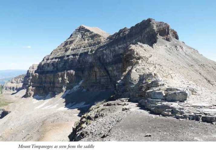
As your feet hit the trail you cannot see your destination. In fact, Mount Timpanogos doesn’t come into view until you hit 10,000 feet and have traveled almost 6 miles along the trail. The Timpanogos Wilderness Area is filled with soaring peaks and dramatic rock faces. The large rock face seen from the trailhead is Roberts Horn. The tallest peak on the left is Elk Point. On the right, Lame Horse Point towers. As you leave the trailhead you begin the path that will take you to the upper echelons of alpine beauty.
Early on the path there is a water faucet for final water bottle refills, and within the first 0.25 mile you reach a fork in the trail. During summer or spring, when runoff is high, the right fork takes you to a bridge that helps in crossing the hard-rushing water but connects back with the main trail in less than 0.1 mile. If you can hear the roar of the river, take the right fork, but be careful you don’t end up heading north on the Lame Horse Trail, which will take you to the Alpine Loop trailhead. If you don’t hear the rush of water, take the left fork, staying on the main trail, and continue west.
In 1984 Congress designated just over 10,750 acres as the Mount Timpanogos Wilderness Area, managed by the US Forest Service. At 0.3 mile you officially enter this wilderness area.
Timpanogos is rich in history. From the World War II–era bomber that crashed on the mountainside in 1955, to the annual “Timp Hike” made popular by Eugene “Timp” Roberts, an athletic director at Brigham Young University in the early 1900s, to the Native American tribes the area was named for, entire books have been written on the area’s history.
In summer the trail is patrolled by TERT, or the Timpanogos Emergency Response Team. This team of volunteers provides emergency assistance and is often found setting up shop around Emerald Lake at the base of The Glacier. TERT also regulates trail use and reports destructive use.
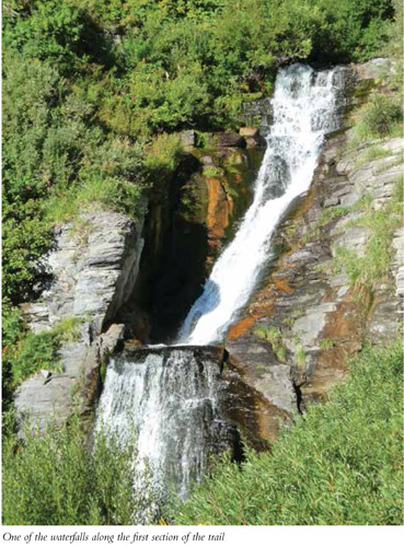
You come to the first waterfall just before the 1.0-mile mark, and the second quickly materializes around the next turn. This section of the trail is rich and lovely in the lush green of a healthy alpine environment. The unnamed stream that drains Primrose Cirque is the source of these falls. At 3.5 miles the trail begins diverging into side trails on a regular basis. Most of these are shortcuts that have been worn into the mountainside by hikers seeking to cut the trail length. Try to stay on the main trail when possible to keep from adding to the erosion. All trails lead up the mountain.
Eugene Roberts, an athletic director at Brigham Young University in Provo, started taking small groups to the summit of Timpanogos in 1912 in the first of fifty-nine such hikes. This first group consisted of nineteen college students and teachers, and the trip was such a success that the event grew larger every year until in 1970 more than 7,000 people participated, with 3,500 reaching the summit. Traditions were established, such as the Friday-night camp-fire program held each year before the Saturday hike. Walking sticks, called “Timp sticks,” were given out; even fireworks came into play. Many photos of these early-20th-century forays can be found in the BYU photo archives.
The environmental nightmare that such a large group created caused the US Forest Service to end the annual trek that had made its way through 60-plus years of history. Today the trail is still very well traveled. Many still attempt the summit, with fewer making it to the top, but group size is limited to fifteen persons.
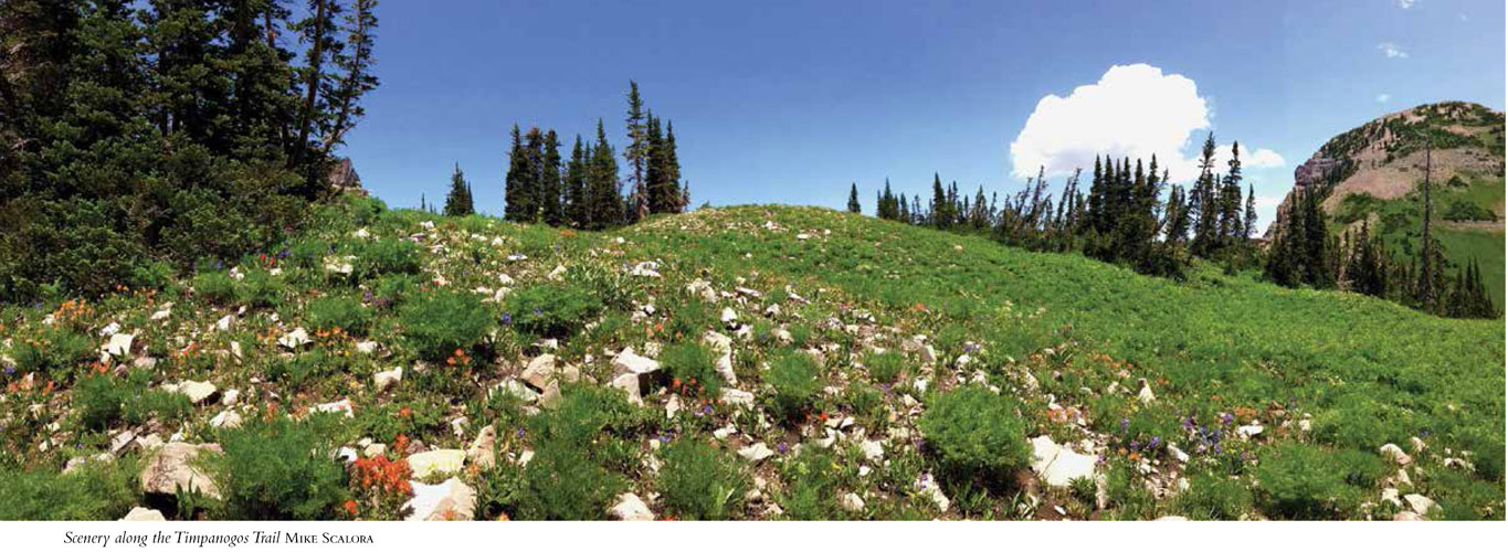
At 9,200 feet of elevation the wildflowers begin to thicken. During the earlier spring runoff there will be more water in the creeks, more streams cutting their way down the mountains, and more waterfalls. Later in the season the wildflowers become more prolific.
You hit Primrose Cirque, named for the primrose wildflower that covers the area, at 4.0 miles. At 4.5 miles the trail appears to continue to the north. Instead follow the path to the south under a steep rock face. The trail becomes clearer as you get past this section.
At 4.8 miles the path forks. Stay to the right. The left fork follows a talus trail into a grove of trees—a fine diversion if you want to rest.
Hidden Lake, sometimes not much of a lake at all, lies at 5.0 miles. This is a popular camping spot, as there is water to be filtered and you can camp in the cirque. From here you have limited tree line, so beyond this point there is a loss of privacy for camping or bathroom stops.
Pack something to keep you warm on the summit. Even on summer days the summit is windy and often cold. Bug repellent, sunscreen, and plenty of water and snacks are a must for this strenuous hike.
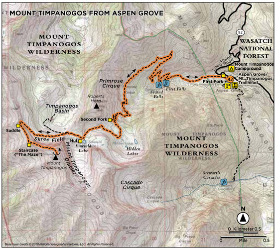
Shortly after Hidden Lakes you hit the 10,000-foot mark and get your first glimpse of Timpanogos. There is an aluminum shack sitting on the summit. From this point you can look back down the way you have come and see into Heber Valley and Deer Creek Reservoir.
Emerald Lake sits at the base of the snowfield often referred to as “The Glacier.” A stone hut sits near the lake. This hut was built in 1959 and used to contain pit toilets. The toilets have been dismantled, but the hut is still used by TERT, the stray hiker who forgot his tent, and others who need it. A herd of mountain goats also frequents this area. Although they are used to the many hikers they see, wildlife should never be harassed. Give them their space.
Many hikers descend the summit by glissading down this snowfield for a quick and thrilling exit. Many hikers also are injured here; if you choose this route, make sure you know what you are doing.
As you continue past Emerald Lake, you begin the most difficult part of the trail. At 5.9 miles the trail opens to the north. From here you can see into American Fork Canyon and over to the highest peaks in Little Cottonwood Canyon, including Pfeifferhorn and Red Baldy. From here you can also look down into the cirque and see the trails merging from the Timpooneke trailhead.
At this point the trail changes to and continues among talus to the summit. You will need sure footing and good ankle support. At 6.0 miles the trail forks in the talus. The right fork takes you down onto the Timpooneke Trail and into the cirque below; the left continues across the talus field. Stay left, crossing the snow if needed. When the talus is hard to follow, look for cairns and just keep heading to the northwest.
When the trail finishes the traverse across the talus, it begins a stiff climb up boulders and dirt to the saddle. At the top of the climb, follow the trail to the left to reach the saddle. The saddle sits at 11,050 feet and could be a destination in itself. Expansive views over the entire Utah Valley and down the other side into American Fork Canyon to the north and Heber Valley to the east make this a great place to stop and enjoy the fruits of your hard work.
From the saddle head south to a rock staircase that takes you up the mountain toward the summit. Known as “The Maze,” the staircase requires sure footing. The mountain is covered with talus, and the approach is exposed; tread carefully. Continue climbing up the talus on trails that are decipherable but varied. A traverse across the mountain brings you just below the summit ridge. Switchbacks then take you up the side of Timpanogos to the grand summit and an aluminum building signed by those who have reached the summit in past years. The reward of the summit makes the struggle well worth it.
The 360-degree views from the summit of Timpanogos must be experienced to be appreciated. Looking down the east side of the summit, you can see directly into Emerald Lake below, and in every direction the view of the world opens to you.
Miles and Directions
0.0 Start at the Aspen Grove/Timpanogos trailhead.
0.2 Come to a fork that will allow you to cross the stream at high water if you are hiking during the spring. No need to use the fork unless the water is high.
0.3 Enter Mount Timpanogos Wilderness Area.
0.4 Previous high-water fork merges back onto the main trail.
0.9 Come to the first waterfall.
1.2 Come to the second waterfall.
3.5 Shortcut trails formed by hikers cutting up the mountain begin.
4.0 Reach Primrose Cirque.
4.5 The trail forks. Head south/left.
4.8 The trail forks. Head south/right.
5.0 Reach Hidden Lakes.
5.7 Come to Emerald Lake and The Glacier. Look for mountain goats here.
The Dangers of Altitude Sickness: If you come from sea level to altitudes above 8000 feet, you could be in danger of developing symptoms of altitude sickness if you don’t give your body time to acclimate to the decreased pressure of the air around you—the barometric pressure. At higher altitudes there is less oxygen in the surrounding air. Symptoms often improve when you descend. If you are coming in from out of town and are used to lower elevations, give your body time to adjust to the thinner air around you.
6.0 The trail forks in the talus. Stay left and continue along the talus. Descending takes you to Timpooneke.
6.6 The trail begins a steep climb to the saddle.
6.7 Come to the saddle.
6.9 Reach the rock staircase called The Maze.
7.2 Reach the summit of Mount Timpanogos. Return the way you came.
14.4 Arrive back at the trailhead.
Options
Option 1: There are 17 miles of maintained trails accessed from two trailheads in the Timpanogos Wilderness Area: Aspen Grove/Timpanogos (where the featured hike begins) and Timpooneke. Mount Timpanogos can be reached from both trailheads. The Timpooneke Trail meets up with the Aspen Grove Trail just below the saddle before the summit. The Timpooneke route brings you up through a steep glaciated valley and a staircase of five flat benches. The Timpooneke trailhead is located in the Timpooneke Campground, 5 miles farther up UT 92, and sits at 7,360 feet of elevation.
Option 2: Return from the summit via a glissade down The Glacier. To take this route, from the summit travel south across the ridge for 0.6 mile to the top of The Glacier, then glissade to the bottom. Be aware that many people have sustained injuries in this area, so take appropriate care.
Hike Information
Local events and attractions: Sundance ski resort, owned by Robert Redford, offers lift-assisted hiking and mountain biking in the summer months. The resort also offers artistic programs and outdoor theater. During winter the resort has downhill skiing, a Nordic center, and ongoing environmental programs. For information call (877) 831-6224 or visit www.sundanceresort.com.
Scenic drive: The Alpine Loop begins near the Aspen Grove/Timpanogos trail-head and winds up the mountain into American Fork Canyon. Considered one of the most scenic drives in the state, especially in fall, it has been designated as a Utah scenic byway.
Camping: Mount Timpanogos Campground sits at an elevation of 7,600 feet and is located just a few hundred feet past the Aspen Grove/Timpanogos trailhead. Sheltered by aspen and fir trees, the campground has vault toilets and drinking water. Reservations are suggested on busy summer weekends. Campers also must have a recreation pass. Passes can be purchased as you enter the Alpine Loop from either end or from one of the self-service fee tubes located at major trailheads. No trailers or RVs longer than 20 feet. This park has first-come, first-served sites. For reservations call (877) 444-6777 or go to www.recreation.gov. Theater in the Pines is a group campground located on the south side of the Aspen Grove/Timpanogos trailhead. Reservation only; call (877) 444-6777.
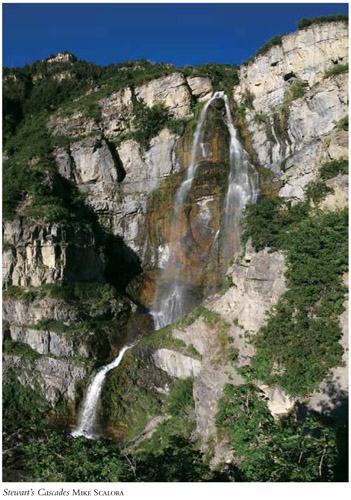
The Timpanogos area is rife with waterfalls, but Stewart’s Cascades, also known as Stewart Falls, are the easiest to access and possibly one of the most scenic. Popular with families, this pleasant, easy trail is often shaded and ends in a beautiful two-tiered waterfall that plunges 200 feet down the mountain. Fall colors are vibrant in this area, but the falls flow with greater intensity earlier in the year. Fir, aspen, and maple surround you in an alpine environment that makes for a dazzling day hike.
Start: Aspen Grove/Timpanogos trailhead
Distance: 3.8 miles out and back
Hiking time: About 1.5 hours
Difficulty: Easy
Elevation gain: 310 feet
Trail surface: Gravel and dirt path
Best season: Summer and fall; winter avalanche hazard
Other trail users Horses
Canine compatibility: Leashed dogs permitted
Land status: Uinta-Wasatch-Cache National Forest; trail mostly on Sundance Resort property
Nearest town: Provo
Fees and permits: Fees required to access Aspen Grove trailhead
Schedule: The hours posted at the information/fee booth at the trailhead vary by season. The trail is never closed. If you arrive and no one is manning the booth there is a self-serve payment required.
Maps: USGS Aspen Grove
Trail contacts: Pleasant Grove Ranger District, (801) 785-3563
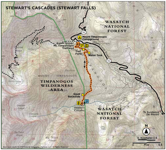
Finding the trailhead: From Salt Lake City take I-15 south toward Las Vegas/Cheyenne. Take the UT 52/800 exit (272) toward US 189. Turn left onto UT 52 and follow for 3.7 miles where the road merges onto Provo Canyon Road. From the mouth of Provo Canyon, head 6.8 miles to the turnoff to Sundance ski resort/UT 92. Turn north and travel 4.5 miles past the Sundance ski area and past the BYU Aspen Grove Alumni Center to the Aspen Grove/Timpanogos trailhead that sits just past the US Forest Service fee booth. The trail takes off on the right side of the restrooms on the west side of the huge parking lot. GPS: N40 24.25' / W111 36.315'
The Hike
Stewart’s Cascades Trail leaves from the southwest side of the parking lot on the trail just north of the restrooms. A trail marker 130 feet up the trail directs you left to Stewart’s Cascades, Trail 56. The trail quickly turns southeast and climbs into a forest of tall evergreens. The view from this corner looks back over lush Primrose Cirque.
At 0.35 mile the trail forks, with the left fork descending to the BYU Alumni Center and the right fork continuing to Stewart’s Cascades. As the trail progresses you pass a big water tank on the left where the BYU Alumni Center stores their water.
The trail winds through old evergreens and young aspen groves and tall, lush ferns during spring and summer. At 1.4 miles the trail forks; continue straight. As you continue around the mountain, Sundance Resort becomes visible, with ski runs cutting through the trees. Privately owned homes cut into the mountains and beautiful foliage that covers the area. The last section of the trail becomes rockier. The trail to Stewart’s Cascades runs through areas that can be ravaged by avalanches during the winter months. You will see evidence of past slides.
In the early 1900s the Stewarts, a family of Scottish immigrants, settled the canyon now known as Sundance. The second generation of Stewarts saw the potential of the surrounding mountains as a ski resort and opened Timp haven in the 1950s. The resort had a chairlift, a rope tow, and a burger shack. In 1969 actor Robert Redford bought Timphaven and surrounding lands from the Stewarts. Redford then proceeded to build what is now known as Sun-dance Resort, a place for skiing, environmental conservation, and artistic exploration. Heard of the Sundance Film Festival? The Sundance Institute? As the resort’s website explains, “Sundance has many shapes, many moods, and many possibilities. . . . ”
The trail reaches an elevation of 7,200 feet before descending 300 feet to the upper falls. Rocky slabs provide a lookout point over the falls. Continue down the trail marked “Sundance” to the lower falls, where you can enjoy the full scope of the falls. After enjoying the area’s scenic beauty, return the way you came.
Miles and Directions
0.0 Start at the Aspen Grove/Timpanogos trailhead.
130 feet Come to the sign for Stewart’s Cascades; turn left.
0.35 The trail forks; go right.
0.5 Pass a BYU water tank off to the left.
1.4 The trail forks; continue straight.
1.65 Pass a giant rockslide.
1.8 Come to the viewpoint for the upper falls.
1.9 Reach the base of the lower falls. Return the way you came.
3.8 Arrive back at the trailhead.
Option
During summer and fall, hikers can ride Sundance Resort’s chairlift to mid-mountain (7,150 feet), where a pleasant downhill stroll brings you in from the south to Stewart’s Cascades at 6,800 feet.
Hike Information
Local events and attractions: Sundance ski resort, owned by Robert Redford, offers lift-assisted hiking and mountain biking in the summer months. The resort also offers artistic programs and outdoor theater. For information call (877) 831-6224 or visit www.sundanceresort.com.
Scenic drive: The Alpine Loop begins near the Aspen Grove/Timpanogos trail-head and winds up the mountain into American Fork Canyon. Considered one of the most scenic drives in the state, especially in fall, it has been designated as a Utah scenic byway.
Camping: Mount Timpanogos Campground sits at an elevation of 7,600 feet and is located just a few hundred feet past the Aspen Grove/Timpanogos trailhead. Sheltered by aspen and fir trees, the campground has vault toilets and drinking water. Reservations are suggested during busy summer months. Campers also must have a recreation pass. Passes can be purchased as you enter the Alpine Loop from either end or from one of the self-service fee tubes located at major trailheads. No trailers or RVs longer than 20 feet. This park has first-come, first-served sites. For reservations call (877) 444-6777 or www.recreation.com. Theater in the Pines is a group campground located on the south side of the Aspen Grove/Timpanogos trailhead. Reservation only; call (877) 444-6777.
GREEN TIP
Rechargeable batteries reduce one source of toxic garbage.
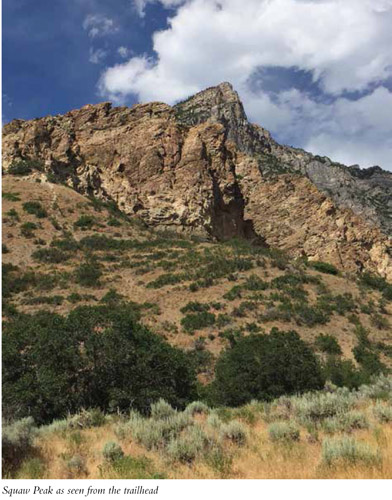
Utah Valley holds one of Utah’s most populous counties as well as some of its most historic cities and sites. Pioneers quickly settled Utah Valley after arriving in Salt Lake in the mid-1800s. Settlement wasn’t easy, and Squaw Peak is rumored to be named for one of the conflicts between Mormon settlers and the Ute tribe, which ended the life of Big Elk’s wife in Rock Canyon. From the valley, the view of Squaw Peak looms jagged, rocky, and impregnable, but the trail is not as difficult as it may appear. In fact, the elevation gain is the hike’s only challenge. The well-used, easy-to-follow trail ends with stunning views.
Start: Rock Canyon Park trailhead
Distance: 7.6 miles out and back
Hiking time: About 5 hours
Difficulty: Difficult
Elevation gain: 2,737 feet
Trail surface: Pavement, rock, dirt, stream crossings, bridges
Best season: Summer and fall; snow often in Rock Canyon until early summer
Other trail users Rock climbers, mountain bikers, horses, and trail runners
Canine compatibility: Leashed dogs permitted
Land status: Uinta-Wasatch-Cache National Forest
Nearest town: Provo
Fees and permits: No fees or permits required
Schedule: Rock Canyon Park is closed from 11 p.m. to 5 a.m. but access to the trail does not close.
Maps: USGS Bridal Veil Falls
Trail contacts: Provo Parks and Recreation, (801) 852-6606
Special considerations: No motorized vehicles. Take plenty of water and insect repellent. Restrooms at the trailhead.
Finding the trailhead: From Salt Lake City head south on I-15 toward Provo for 46 miles. Take exit 269 onto UT 265 (University Parkway) and head east for 3.2 miles. Turn left onto 2230 North, which becomes 2200 North. After 1.1 miles turn left onto North Temple Drive. Follow the road east for 0.9 mile to the mouth of Rock Canyon. The trail starts at the east end of the parking area. GPS: N40 15.870' / W111 37.804'
The Hike
Popular with students at Brigham Young University as well as area high school students, Rock Canyon is often populated with hikers and rock climbers who are enjoying the limestone and quartzite that make up the amazing rock for which the canyon is named. Hikers looking for more of a challenge head up First Left Fork for the hike to Squaw Peak. Rock Canyon trailhead has two parking lots (upper and lower), restrooms, and interpretive signs on the area’s flora, fauna, geology, and history. This trailhead is also an entry to the Bonneville Shoreline Trail, so it is easily one of the busiest recreational areas in the valley.
The trail to Squaw Peak can be defined in three parts. The first is the hike up Rock Canyon, the second is the climb up First Left Fork, and the third is the climb to the summit. The most difficult aspect is the steady climb up First Left Fork, but the trail is forested and easy to follow. The summit provides 360-degree views of Utah Valley that include Utah Lake, Brigham Young University, the LDS Provo temple, and LDS Missionary Training Center. Owned and operated by the Church of Jesus Christ of Latter-Day Saints, Brigham Young University is internationally renowned. Founded in 1875 as Brigham Young Academy, it has become one of the nation’s largest and best known private universities. The mind-boggling view down into Rock Canyon includes dramatic rock formations pushed up almost vertical because of their location along the Wasatch Fault. The view of Cascade Mountain to the east, Timpanogos to the north, and Provo Peak to the southeast combine to provide the summit reward.
In 1934 the Civilian Conservation Corps (CCC) helped build debris basins to catch the trees, mud, and rocks that flowed out of Rock Canyon. Overgrazing had decimated the area flora and resulted in massive erosion. After many efforts over the years to stabilize the canyon, the watershed is back in place and the canyon is healthy. Water is now diverted into pipes, providing 5 percent of Provo’s potable water.
The trail leaves the parking area on the east, following the gravel road that heads into Rock Canyon. From here you can see Squaw Peak high above to the left. A short way up, the road forks; stay right. The road cuts through Gambel oak and passes beneath fascinating geology, including a cave to the left (north) and rock climbing walls. Smaller trails intersect the main road up Rock Canyon, but stay on the main gravel road/trail, crossing the stream and wooden bridges as they appear. The first bridge appears at 1.1 miles. At 1.8 miles the turnoff for First Left Fork is off to the left. This turnoff is not easy to see. A 060 flexible brown Forest Service trail marker on the main gravel road marks the trail forward. The marker is the indicator that you are at the turnoff for Squaw Peak—First Left Fork.
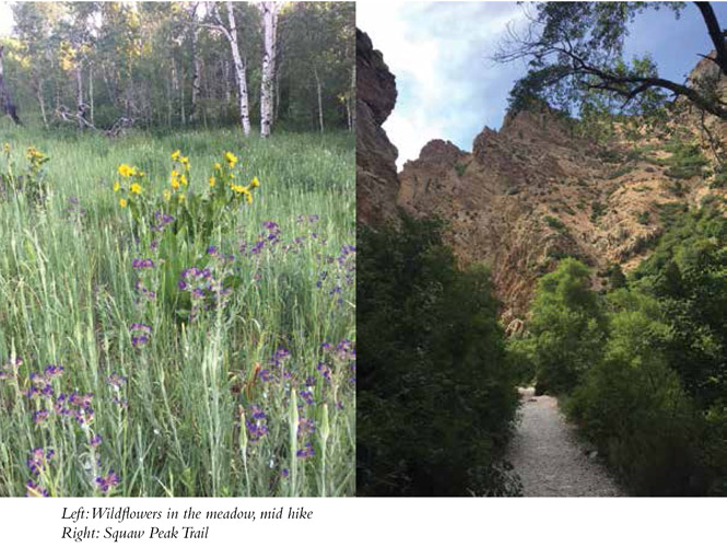
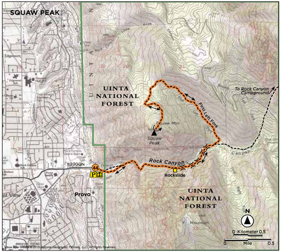
First Left Fork is a singletrack dirt trail that intersects the main road from the left. A medium-size rock with the words “Squaw Peak Trail” painted on it sits at the opening of the trail. The trail heads northeast up First Left Fork under a canopy of trees. The trail is a beautiful climb through groves of aspen, oak, and maple. It is well shaded in many places, but most of your elevation gain is experienced in this section of the trail—more than 1,000 feet in just over 1.0 mile, with no switchbacks. At the top of the fork, at 3 miles, the trail enters a meadow and swings southwest, where the trail levels out a bit for some easy strolling. The trail then climbs to the ridge that overlooks Utah County below. Views open of Utah Lake to the west and Buffalo Peak to the east. The last 0.5 mile of the climb is up Squaw Mountain to the peak—a rocky summit with large tabletop rocks for sitting and enjoying the view. From here you can look down into the sharp dropoff of Rock Canyon to the southeast, where you can really gain an understanding of how the canyon got its name; Provo and Utah County to the west; Cascade Mountain (10,908 feet) to the east; Mount Timpanogos (11,749 feet) to the north; and Provo Peak (11,068 feet) to the southeast. Enjoy the view and then return the way you came.
Miles and Directions
0.0 Start at the Rock Canyon Park trailhead.
0.3 Come to a rock climbing slab with sport routes off to the right side of the trail.
0.4 You can see a cave up to your left.
0.45 The paved trail transitions into gravel. A green gate crosses the road here; the trail goes around it to the left. The rock face around the gate is called “The Kitchen” and is a popular rock climbing area.
1.1 Come to the first of five consecutive bridge crossings. There may or may not be water, depending on the time of year.
1.8 Reach the First Left Fork; turn left off the main trail. Look for the rock at the trail junction that says SQUAW PEAK.
3.0 Trail opens to the meadow.
3.3 The trail hits the ridge.
3.8 Reach Squaw Peak. Return the way you came.
7.6 Arrive back at the trailhead.
Hike Information
Camping: Hope Campground sits at 6,500 feet, 5 miles up Provo Canyon on Squaw Peak Road. Twenty-four single campsites and two double sites sit among maples, scrub oak, and fir. For reservations call (877) 444-6777 or go to www.reserveamerica.com or www.recreation.gov.
Rock Canyon Campground is located just upcanyon from the Squaw Peak hike, but the reservation-only group campsite is accessed via Squaw Peak Road. The primitive campground has no running water, so bring your own. Sitting above Utah Valley at 6,500 feet, the forested campground offers plenty of shade, meadows, and wild-flowers. For more information or reservations, visit www.reserveamerica.com or call the park at (801) 885-7391. Campground host is located at Hope Campground.
Rock Canyon trailhead is home to an amphitheatre, restroom, and pavilion. To rent the picnic pavilion, go to 311.provo.org or call (801) 852-6000. A seven-day notice is needed for reservations. You may reserve the pavilion between 8:30 a.m. to 2:30 p.m. or 3:30 p.m. to 9:30 p.m.
GREEN TIP
Don’t pick the wildflowers; leave them for others to enjoy.