Deseret Peak, tallest peak in the Stansbury Mountains west of Salt Lake City, affords views over the Skull Valley to the west and Tooele County to the east that you can get from no other location. Besides a tallest-summit notch, the first section of the trail winds through a beautiful forested area to the saddle and then opens to a rocky, bare ascent to the summit. Douglas fir, alpine fir, and aspen are common on the north-facing slopes, while juniper, sagebrush, and grass cover terrain at higher elevations—a mixed bag of desert and alpine trekking. A full-day adventure, the hike to Deseret Peak is not as crowded as trails in the Wasatch Range, making solitude another benefit.
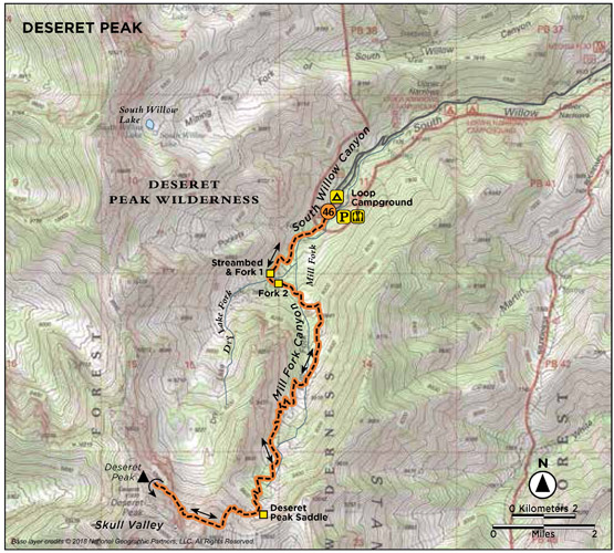
Start: Top of Loop Campground; Mill Fork trailhead
Distance: 8.0 miles out and back
Hiking time: About 5.5 hours
Difficulty: Strenuous
Elevation gain: 3,550 feet
Trail surface: Dirt, talus, and sandy gravel
Best season: Late summer and fall; snow possible on upper sections of the trail until late June
Other trail users Horses
Canine compatibility: Dogs permitted
Land status: Deseret Peak Wilderness Area; Uinta-Wasatch-Cache National Forest
Nearest town: Grantsville
Fees and permits: No fees or permits required
Maps: USGS Deseret Peak East, Deseret Peak West
Trail contacts: Salt Lake Ranger District, 6944 South 3000 East, Salt Lake City 84121
Special considerations: The saddle, ridges, and summit are often windy. Be prepared by carrying a jacket to keep warm; throw in the bug repellent too.
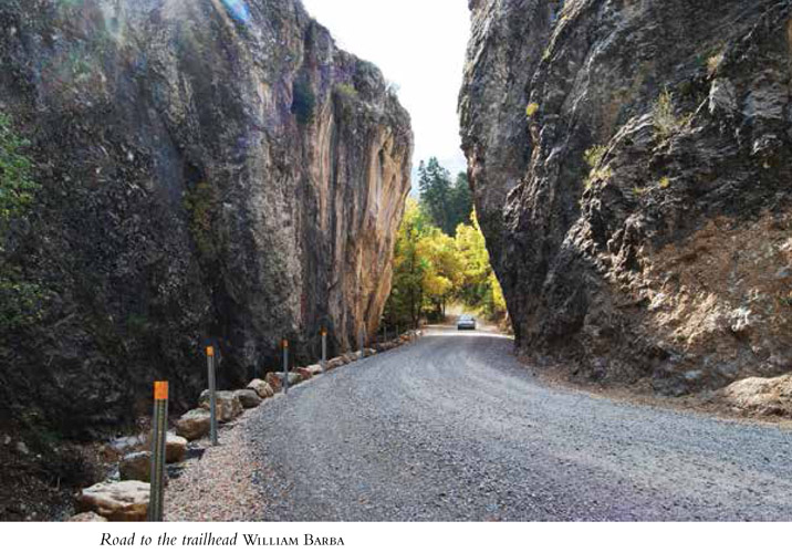
Finding the trailhead: From Salt Lake City drive west on I-80 for 20 miles to UT 36 (exit 99). Drive south toward Tooele for 3.5 miles to Mills Junction. Turn west onto UT 138 and drive 11 miles, through Grantsville, to West Street/400 West and a sign directing you to South Willow Canyon. Turn left and continue for 6 miles and then turn right onto South Willow Canyon Road. After about 3.3 miles the road is no longer paved; continue on the dirt road. Two miles up the dirt road, the trail forks for the Boy Scout Camp. Go straight at this junction and in 1 mile pass beneath rock walls that line the roadside. Follow the road for another mile to the top of Loop Campground and the Mill Fork trailhead. The trailhead has pit toilets, a trail marker, and parking for ten cars. GPS: N40 28.978' / W112 36.404'
The Hike
Utah is one of only two states that hold three distinct geological zones: the Colorado Plateau, the Rocky Mountains, and the Great Basin. The Great Basin occupies western Utah and is often called the “west desert.” Vast desert valleys cut with occasional mountain ranges stretch westward, but these cannot be seen from the Wasatch Front. The Stansbury Mountains, the range that flanks the west side of Tooele County, is the most accessible of Utah’s Great Basin ranges and thus holds the best collection of hiking trails in the basin. Deseret Peak, the tallest peak of the range, sits at 11,030 feet.
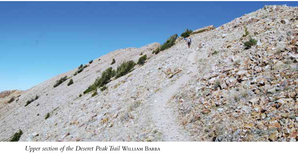
The value of the area was noted, and the Deseret Peak Wilderness Area was added to the Utah Wilderness Act of 1984. The area now includes 25,212 acres, all managed by the US Forest Service. Enjoyed by hunters in fall, hikers in summer and early fall, and backcountry skiers in spring and winter, Deseret Peak and the surrounding chutes have a personality that smacks of the semiarid wilderness it occupies. Located in the zone between the Great Basin and the Rocky Mountains, the climb to Deseret Peak sports both mountain and desert feels. To reach the top of the limestone escarpment that is Deseret Peak, one travels forested paths as well as naked, rock-strewn hillsides past little more than crooked old juniper trees.
SALTAIR—RESORT/CONCERT HALL/AMUSEMENT PARK
Saltair, designed by Richard K. A. Kletting, Utah’s foremost architect at the turn of the 20th century, was built on the shores of the Great Salt Lake as a place of “wholesome recreation.” The Mormon Church wanted to provide a resort that would be enjoyed by the residents of the state and all who came to Utah: a typical amusement park with roller coaster, merry-go-round, Ferris wheel, midway games, bicycle races, rodeos, bullfights, swimming at the lake, fireworks, and dancing on the world’s largest dance floor.
Envisioned as the “Coney Island of the West,” Saltair opened on Memorial Day 1893 and hit its peak in the early 1920s, attracting close to half a million visitors each year, but this 32-year stint was to be the resort’s heyday. In 1925 Saltair burned to the ground, and though many attempts were made to resurrect the resort, they have been curtailed by fire, flood, and salt corrosion. Today Saltair has a concert stage where local and national artists occasionally play.
Mill Fork trailhead sits at the top of Loop Campground. The trail leaves the parking area from the southwest corner and meanders up South Willow Canyon for 0.7 mile, where you come to a streambed and two important forks in the trail, one right after the other. Two trails take off on the other side of the stream. The right fork, the most obvious one, heads up and to the southwest; the left fork is 100 feet below and heads down. Cross the stream and follow the left fork, taking the lower trail. The second fork, which is signed, immediately appears. Follow the signs and again take the left fork to continue to Deseret Peak. (The right fork goes to South Willow Lake.) The trail climbs up Mill Fork and at 1.8 miles exits the tree cover and enters a meadow where you get an open view of the steep, rocky cliffs and mountains around you. The meadow is full of dead trees from an old fire, beetles, and avalanche debris. The trail winds its way through the meadow and continues up and out of Mill Fork to the saddle at 10,000 feet.
At the saddle is a barren four-way intersection with signs pointing to Deseret Peak, Antelope Canyon, Bear Fork, and back the way you came to Loop Campground. Take the right (northwestern) trail up the rocky south-facing mountain, which leads near the chutes and a giant, jagged cliff face; traverses two talus piles; and finally reaches the summit.
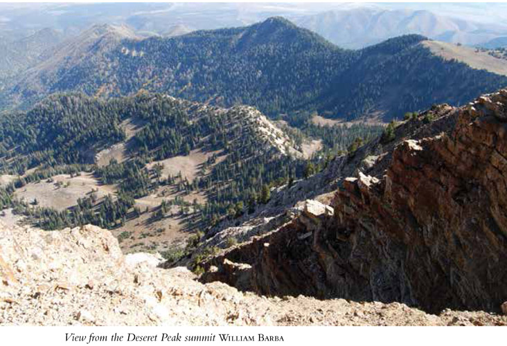
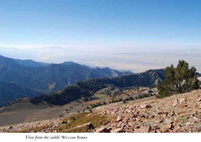
The summit affords 360-degree views of Skull Valley to the west and the Skull Valley Goshute Indian Reservation adjacent to the wilderness area; the Great Salt Lake and Stansbury Island to the north and east; and the Oquirrh and Wasatch Ranges and Tooele County to the east—a view you can’t get from any other vantage point. Deseret Peak allows a peek into the vast west desert and an isolated area void of cities and crossed by very few roads. After enjoying the view, return the way you came.
0.0 Start at Mill Fork trailhead.
200 feet Enter Deseret Peak Wilderness Area.
0.7 Cross a stream and come to two forks, one right after the other; take the left fork at both.
1.8 Exit the tree cover and enter a meadow.
3.3 Reach the saddle at the top of the canyon and a four-way intersection. Head right (northwest) along the trail.
3.9 Come to a dominant jagged cliff face along the path.
4.0 Reach Deseret Peak. Return the way you came.
8.0 Arrive back at the trailhead.
Option
The trail to Deseret Peak can be hiked as a loop. From the peak the loop continues north on the summit ridge before it drops down below the ridge onto the west side on paths that are less defined and not well maintained. Confused hikers can find themselves heading down the wrong drainage, but many enjoy the loop aspect that eventually makes its way back into Mill Fork Canyon.
Hike Information
Local events and attractions: The Upper Narrows, a spot along the road where the walls of the canyon narrow down to the roadbed, are home to a dozen climbing routes. The creek flows at the base of the limestone cliff, requiring some maneuvering to get on the routes. A stick-clip is helpful for getting started.
The Stansbury Mountains are the centermost of three prominent north–south mountain ranges including the Oquirrh Mountains to the east and Cedar Mountains to the west.
Camping: There are five US Forest Service campgrounds located in South Willow Canyon: Cottonwood, Loop, Upper Narrows, Lower Narrows, and the Boy Scout campground. Each campground has fewer than ten sites (fee required) available with fire rings and picnic tables, but water and garbage receptacles are not provided. Please pack out all trash. A number of campsites are nestled near Willow Creek. Camp in designated sites only. Reservations can be made for Upper Narrows campground at www.reserveamerica.com.
GREEN TIP
When driving, don’t let any passenger throw garbage out the window. Keep a small bag in the car that you can empty properly at home.