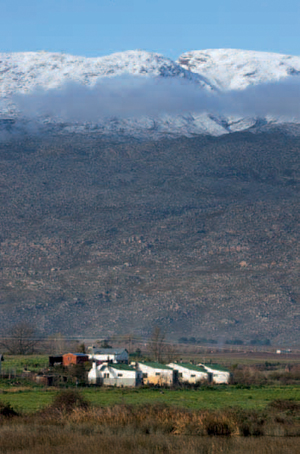
ABOVE: The Ceres Valley, distinguished for the delicious fruits grown there, has chilly winters and is often called the Switzerland of South Africa.
The Warm Bokkeveld is defined by the Gydo and Waboom mountains in the north, the Witzenberg and Skurweberg in the west and the Hex River Mountains to the south. To the east it borders on the Central Karoo.
Matroosberg, the highest point in the Hex River Mountains, rises 2 249 m above the valley. Numerous streams and tributaries of the Breede River, which has its headwaters in the Warm Bokkeveld basin, provide an abundance of water to the intensively cultivated valley, which is a tapestry of orchards, clumps and rows of pine trees, wheat fields and dams.
When the first Dutch stock farmers arrived in this corner of the inland plateau, they named it the Bokkeveld after the vast herds of springbok, wildebeest and zebra that migrated to the area in early spring. The warmer climate of the Warm Bokkeveld distinguishes it from the higher-lying Koue Bokkeveld, which has a much harsher climate.
Despite its small size, the Warm Bokkeveld is an important agricultural region and a popular destination for outdoor enthusiasts.
The Warm Bokkeveld enjoys a Mediterranean climate with hot summers, but the heat is tempered by the altitude as high mountains shelter the valley from strong southeasterly winds. Winters are wet and cold and heavy snowfalls are not uncommon on the mountains in midwinter. The main town, Ceres, is dubbed the ‘Switzerland of South Africa’ and many Capetonians flock here when good snowfalls have been reported.
The San, the first known people of the area, left a legacy of rock paintings in caves and overhangs in the surrounding mountains.
For more than half a century after the Dutch arrived at the Cape, the towering mountains of the Warm Bokkeveld presented a formidable barrier to the expansion of the small settlement. It was only in 1727 that the first European stock farmers crossed the Witzenberg range from the adjacent Tulbagh Valley.
The completion of Michell’s Pass in 1848, which links the Warm Bokkeveld to the Breede River Valley, reduced the travelling time of a transport wagon from Cape Town to Beaufort West from 20 to 12 days. Ceres became a major staging post on the main route to the north and in the late 1860s and early 1870s the town boomed after the discovery of diamonds in the Northern Cape. Its fortunes waned, however, when the railway line between Cape Town and Kimberley was completed in 1885.
In the early 1900s, deciduous fruit farming began replacing stock and wheat farming.
A profusion of proteas, ericas, reeds, lilies, orchids and other fynbos plants grow in the mountains surrounding Ceres. The slopes are particularly attractive in spring when they are covered in masses of flowering ericas. The Ceres sugarbush is among the large variety of protea occurring in the area.
Cape grysbok, klipspringer, grey rhebok, baboon and a host of smaller mammals inhabit the mountains.
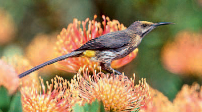
Birding enthusiasts can expect to spot typical fynbos birds such as the Cape sugarbird, protea seed-eater, Cape rock-jumper and orange-breasted sunbird.
ABOVE: The brightly coloured Cape sugar-bird is one of several fynbos endemics.
Ceres, the principal town of the Warm Bokkeveld, was named after the Roman goddess of growing plants in recognition of the valley’s rich soil, and lies at the eastern end of Michell’s Pass. A settlement was established on the western bank of the Dwars River in 1849 and further expansion came when plots were sold on the eastern bank six years later.
The surrounding orchards produce pears, apples, peaches, plums, cherries and apricots. Fruit that is not exported or sold on the local market is canned, dried, or made into juice. Visits to fruit farms can be arranged in picking season (December to April).
Ceres is an attractive town with streets lined by oak trees and well-kept gardens. It is especially attractive in autumn when the leaves change colour. Lovers’ Bridge, a pedestrian walkway supported by dressed sandstone columns over the tree-lined Dwars River, is a landmark in the town.
An interesting collection of antique wagons and equipment used by farriers and wagon makers can be seen in the Togryersmuseum (‘transport riders’ museum’).
The school chapel, built in 1864, was later enlarged to serve as St Andrew’s church, while the Dutch Reformed church was consecrated in 1881.
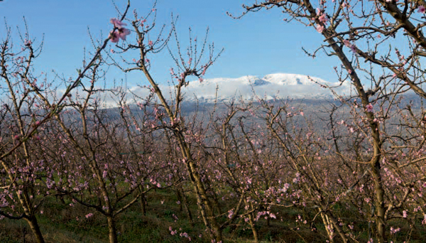
ABOVE: In winter the mountains surrounding the Warm Bokkeveld are often capped with snow.
The Matroosberg Private Nature Reserve is situated on a working deciduous fruit, onion and protea farm, 34 km east of Ceres. Covering over 1 000 ha of unspoilt mountain land, including Matroosberg Peak, the reserve offers excellent birding opportunities, a host of outdoor recreation activities, and tours of the farm. Accommodation options range from self-catering chalets and campsites to a ski hut high in the mountains.
The village of Prince Alfred Hamlet at the foot of the Gydo Pass was laid out on the farm of Johannes Goosen in 1861, and named after the second son of Queen Victoria, who had visited South Africa a year earlier.
The Dutch Reformed church, built in 1906, was converted into a hall after a new church was consecrated in 1964. Prince Alfred Hamlet is the terminus of the branch railway that linked Wolseley and Ceres in 1912 and is a centre for the surrounding deciduous fruit farms. The area is also a major producer of table potatoes, seed potatoes and onions.
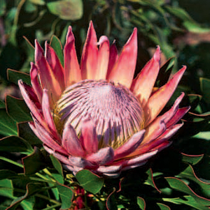
ABOVE: The magnificent king protea, South Africa’s national flower, can be found in the region, preferring sandstone slopes or Bokkeveld shale.
ACTIVITIES
• Trout angling in mountain streams in and around Ceres
• Skiing and snowboarding on the Matroosberg near Ceres
• Quad biking, abseiling, birdwatching, horse riding and camping at the Matroosberg Private Nature Reserve near Ceres
• Trips to the summit of the Matroosberg in a 5-tonne Bedford 4x4 truck
• Paragliding from Gydo Pass near Prince Alfred Hamlet
• Birdwatching along Gydo Pass near Prince Alfred Hamlet
• Mountain biking on several farms in the region
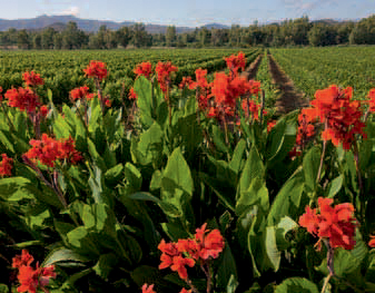
ABOVE: Canna flowers provide a blaze of red amid the verdant vineyards of the Boland.
ROUTES AND TRAILS
• Day walks and hiking trails on several farms in the region
• Matroosberg Hiking Trail (6 hours)
• Christie Prins Hiking Trails (2–4 hours) in Prince Alfred Hamlet
• Various 4x4 trails in the Matroosberg Private Nature Reserve near Ceres.