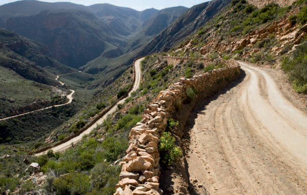
ABOVE: The Swartberg Pass, north of Prince Albert, is a monument to the ingenuity of master road engineer Sir Thomas Bain.
To travellers speeding along the N1 across the vast expanse of the Karoo, the landscape appears bleak and uninteresting. However, those who are prepared to set aside preconceived ideas and spend some time in the Koup will soon learn to appreciate its wide open spaces, crisp air filled with the scent of aromatic Karoo bushes, fascinating plant life and fossils galore.
One of several sub-regions of the Great Karoo, the Koup’s northern boundary is formed by the rugged mountains of the Nuweveldberge, while the Swartberge form a natural border to the south. Lengthways, it extends from the town of Touws River in the southwest to Beaufort West in the northeast.
The climate of the Koup is one of extremes. Summer temperatures of above 40 °C are not uncommon, while temperatures can plummet to -5 °C in winter. Rain occurs throughout the year, but peaks between January and March.
The arrival of the trekboers (migratory stock farmers) in the Koup around the 1750s resulted in the San’s loss of their hunting grounds and waterholes. They retaliated by raiding farms, stealing cattle and murdering farming families. The trekboers responded by organising commandos to exterminate the San, whom they regarded as vermin.
Xhosa-speaking people fleeing conflicts between rival chiefs in the Eastern Cape also settled in the Karoo. Their herds of cattle needed water and grazing and this also brought them into conflict with the trekboers.
These clashes resulted in the proclamation of a new district under the Graaff-Reinet magistracy in November 1818. The British governor at the time, Lord Charles Somerset, named the district and the new town after his father – the fifth Duke of Beaufort. On 3 February 1837, Beaufort became the first town in South Africa to receive municipal status. It was later renamed Beaufort West to avoid confusion with Port Beaufort and Fort Beaufort.
Following the completion of the Hex River Pass in the 1860s, outspans (areas on farms where travellers and their animals could rest) were established along the wagon road to the interior. But it was the building of the railway line from the Cape to the Witwatersrand which boosted the establishment of settlements, such as Laingsburg and Leeu-Gamka, around the railway stations.
Wool sheep were introduced in the region by a farmer named Arthur Kinnear in 1836 and the Koup is now one of the country’s major producers of wool and mutton.
The Koup region lies in the Nama Karoo biome, which covers nearly a third of the country’s surface. A great many of the 7 000-odd plant species of the Nama Karoo occur in the Koup. Typical low Karoo bossies (bushes) and shrubs with descriptive names such as perdekaroo (‘horses’ Karoo’), gombossie (‘gum bush’), springbokbos (‘springbuck bush’), inkbos (‘ink bush’) and kapokbos (‘snow bush’) dominate the vegetation of the plains. Mesembs, commonly known as vygies, and perennial grasses are other important constituents of the Karoo vegetation.
Adapted to the harsh environment, the seeds of Karoo plants can lie dormant for up to 70 years. Germination takes place after good rains at almost any time of the year, but soaking rains in autumn and early winter, followed by 10 to 14 days of mild, overcast weather, provide the best conditions.
Uncontrolled hunting, overgrazing and the erection of fences soon wiped out the large herds of game that once freely roamed the plains, and the Koup gradually turned into a desolate landscape. The first soil conservation plan was implemented in 1954 and a new one was introduced six years later. Despite efforts to combat overgrazing and soil erosion, just over two decades ago the Karoo region was still overstocked by almost 30%.
Proteas, ericas, reeds and rushes dominate the fynbos vegetation of the Swartberge. The dry, lower northern slopes are characterised by typical Karoo plants.
The Swartberg Complex, which lies at the centre of the Swartberge, is one of eight separate conservation areas of the Cape Floral Region, which was declared a UNESCO World Heritage Site in 2004.
From the Hex River Valley, the Great North Road (N1) gains nearly 500 m in altitude as it climbs to Touws River, lying at the southwestern corner of South Africa’s interior plateau.
In its heyday, during the era of steam trains, Touws River was a busy locomotive depot and marshalling yard, but its fortunes waned when diesel locomotives were introduced.
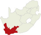
ABOVE: Near-vertical cliffs, festooned with lichens, guard the narrow northern entrance of the Swartberg Pass, which was officially opened in 1888.
Touws River was one of several observation stations set up in South Africa to observe the transit of Venus in December 1882. The objective of the British expedition stationed here was to measure the distance between the earth and the sun. Two concrete pillars in the grounds of the old Douglas Hotel are reminders of South African astronomy in the 19th century.
What was once just a railway halt was transformed into a charming Victorian village by an enterprising Scotsman, James (Jimmy) Douglas Logan, in the mid-1880s.
In those days trains did not have dining wagons, and it did not take Logan long to realise that there was money to be made from the lucrative refreshment-room concessions. He began by obtaining the lease for the railway-owned hotel at Touws River Station, and eventually secured all the concessions from Cape Town to Bulawayo.
Logan began developing Matjiesfontein, then a lonely railway siding, in 1884. Here, he developed a late Victorian-style health and holiday resort that attracted famous people like Cecil John Rhodes, Lord Randolph Churchill (father of Sir Winston Churchill), the Duke of Hamilton and the Sultan of Zanzibar. Olive Schreiner, the author of Story of an African Farm, lived at Matjiesfontein for a few years.
Matjiesfontein sank into obscurity after Logan’s death in 1920, but was saved from certain demise when well-known hotelier David Rawdon bought the entire village in 1968 and restored it to its former splendour.
The towered Lord Milner Hotel, the Laird’s Arms Victorian country pub, the wood-and-iron Masonic Losieshuis (boarding house), the post office and the double-storied general store (now the Coffee House) are among the many outstanding buildings in the village that is a virtual open-air museum. An extensive collection of Victoriana is on display in the Marie Rawdon Museum, named after the owner’s mother.
A little more than a century after Laingsburg was established, the town made headlines in January 1981 when the Buffels River burst its banks after 425 mm of rain fell in its catchment area in just two days. The devastating flood destroyed 184 houses and killed 104 people, many of whom were swept away by the raging floodwaters. The flood-level marker opposite the Dutch Reformed church in Main Street is a reminder of one of South Africa’s worst natural disasters in living memory.
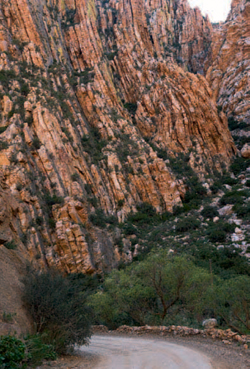
ABOVE: The Union Jack flying over Matjiesfontein further adds to the town’s Victorian atmosphere.
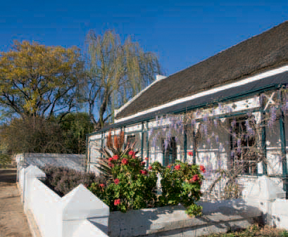
Laid out in the foothills of the Swartberge in 1842, Prince Albert has retained much of its old-world charm. The picturesque farming village with its leivore (water furrows) and tree-lined streets is an architectural gem, with building styles ranging from simple Karoo houses to Victorian homes with decorative cast-iron columns and lacework, wooden fretwork and verandas.
The town is also renowned for its Cape Dutch houses with their distinctive Prince Albert gables. These holbol gables have alternating concave and convex curves with a small round or triangular pediment on the top. The gable window is typically flanked by two pilasters, while matching horizontal moldings connect the convex moldings.
The best way to explore the town’s rich architecture is to buy a copy of the Prince Albert Historical Route pamphlet at the tourism bureau and to explore the town on foot. The bureau is housed in the Fransie Pienaar Museum, which depicts the town’s history and its surroundings.
The normally tranquil village becomes a hive of activity in May when the annual Olive Festival takes place.
In the 1830s, a group of hardy farming families settled in a remote valley in the folds of the Swartberge. Blessed with an abundance of water and fertile soil, the Kloovers (‘ravine people’), as they called themselves, reared livestock and cultivated wheat, fruit and vegetables. In time, the valley became renowned for its dried raisins, dried fruit and its witblits (‘white lightning’) – a potent home-distilled spirit.
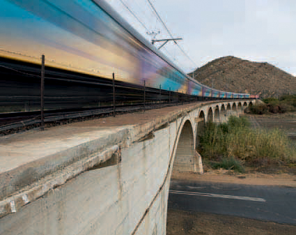
ABOVE: Laingsburg, a centre for the surrounding farms, was an important stop on the railroad between Cape Town and Johannesburg during the days of steam trains.
ABOVE: Prince Albert is an architectural gem, its streets lined with many fine Victorian and Karoo houses.
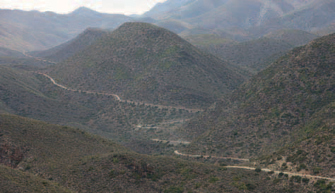
ABOVE: A long and winding road leads to Gamkaskloof, a remote valley in the Swartberge.
By the early 1900s, the valley was already known as Die Hel (‘the hell’) – a name that was resented by the Kloovers. For more than 130 years, the only access into Gamkaskloof was on foot or by donkey. Prolonged droughts, followed by devastating floods, tested the mettle of the Kloovers.
The completion of the road from the Swartberg Pass to Gamkaskloof in 1963 finally brought about drastic changes. Young people left to attend school in the towns, the elderly and the sick moved away and an increasing number of visitors attracted by the name ‘Die Hel’ disturbed the tranquillity of the valley.
Gamkaskloof came under the control of CapeNature in the early 1990s – after the last inhabitants left the valley in 1992. Visitor facilities include accommodation in restored cottages; campsites with cold-water ablutions and braai facilities; and a bush camp with hot showers and braai facilities.
A four-wheel drive vehicle is essential for the 37 km journey to Gamkaskloof. The final 4 km zigzags along the Elandspad to the valley, losing several hundred metres in altitude.
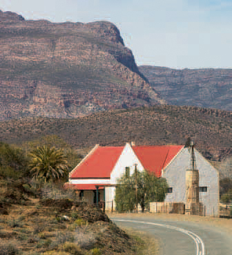
The farming village of Klaarstroom was established on the farm De Klaare Stroom (‘the clear stream’) after completion of the road through Meiringspoort in 1858. The first plots were laid out in 1860 along a single street and the village, with its Karoo-style and Victorian houses, general-dealer store, Victorian police station and post office has changed little since the days when it was an important stop on the wool route between the Karoo and the coast.
Once an outspan on the wagon route to the north, Leeu-Gamka became an important stop after diamonds were discovered at Hopetown in 1866 and at Kimberley in 1871. It received another boost when the railway reached the settlement in 1879, and many famous personalities of the time stretched their legs on the platform of the small railway station.
Disaster struck when the N1 was moved to its present position in 1943 as most motorists simply sped past. Leeu-Gamka gradually sank into obscurity. Buildings of architectural interest include the railway station, the 1898 Leeu-Gamka Hotel and the Dutch Reformed church.
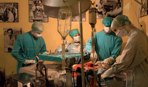
Beaufort West, the largest town in the region, lies in the heart of the Great Karoo. Pear trees, cypresses and leivore line the main street. The Beaufort West Town Hall, which was inaugurated in 1866, is the focal point of the Beaufort West Museum complex. The historic building has been dedicated to the town’s most famous son, Dr Christiaan Barnard, who performed the world’s first successful human heart transplant at Groote Schuur Hospital in Cape Town in 1967. Several hundred awards and gifts presented to Dr Barnard after this medical feat are on display and there is also a reconstruction of the operating theatre.
The Dutch Reformed mission church is situated next to the town hall. It was here that the pioneer heart surgeon’s father, Reverend Adam Barnard, preached to his flock from 1911 to 1948. Adjoining the mission church, which dates back to 1872, is the parsonage where young Christiaan grew up.
KAROO NATIONAL PARK
Situated on the outskirts of Beaufort West, the Karoo National Park was proclaimed in 1979 to protect an area representative of the region. The municipality of Beaufort West donated 7 209 ha of commonage, the central government made money available and funds were raised by the Southern African Nature Foundation by selling stamps – each representing 1 acre of Karoo.
The park is a sanctuary for herds of springbok, gemsbok, Cape mountain zebra, buffalo, red hartebeest, black rhino and several raptor species. Eland, kudu, klipspringer, bat-eared fox, black-backed jackal are among the other animals to be seen.
The park can be explored along two self-drive routes: a tarred circular drive across the low-lying plains of Lammertjiesleegte, or a 50-km circuit through the western part of the park. Guided game drives and night drives are conducted in open vehicles.
Accommodation in the rest camp is available in self-catering Cape Dutch-style cottages, while those preferring the outdoors can opt for shady campsites. A restaurant, shop and swimming pool are other facilities in the rest camp. The Bulkraal day-visitor area has picnic sites, a swimming pool and ablution facilities.
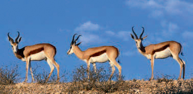
ABOVE: Herds of springbok roam the plains of the Karoo National Park at Beaufort West.
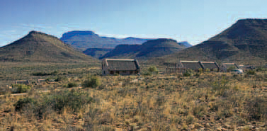
ABOVE: Visitors to the Karoo National Park are accommodated in Cape Dutch-style cottages.
ACTIVITIES
• Buying farm produce at the Gamkaskloof Kiosk in Gamkaskloof
• Camping in Gamkaskloof
• Tasting olives in Prince Albert, especially during the May Olive Festival
• Viewing local architecture at various locations
• Identifying Karoo bossies and other flora
ABOVE: Klaarstroom, a farming village near the northern entrance of Meiringspoort, has changed little in the last 150 years.
ROUTES AND TRAILS
• Two 4x4 Eco Adventure Trails (2–6 hours and 5–6 hours) in the Karoo National Park
• Out-and-return 4x4 trail (54,4 km; day or overnight route) in the Swartberg Nature Reserve
• Pointer Hiking Trails (1.5–3 hours) in the Karoo National Park
• Bossie Trail (800 m) and Fossil Trail (400 m) in the Karoo National Park
• Country Walk (1.5 hours) in Prince Albert, starts and ends in Church Street
• Koppie Trail (1 hour) in Prince Albert, starts in Berg Street and ends in Crosby Street
• Karoo Walk (1 hour) in Prince Albert, starts and ends in Christina de Wit Street
• Ghost Walk (1.5 hours) in Prince Albert, starts and ends in front of the Fransie Pienaar Museum in Church Street
• Swartberg Hiking Trail (day walks to 5 days) in the Swartberg Nature Reserve
• The Donkey Trail (4 days), a guided hiking trail over the Swartberg, following the original donkey trail between Calitzdorp and Gamkaskloof, where donkeys carry the equipment
ABOVE: A diorama depicting the world’s first heart transplant can be seen in the Beaufort West Museum.