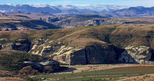
ABOVE: Mixed grasslands dominate the Upper Karoo plains of the Eastern Cape Midlands near Cradock.
The contrasting scenery of the Eastern Cape interior ranges from wild valleys and plains punctuated by hills to towering mountain peaks and spectacular sandstone formations. With five biomes meeting here, the region’s natural beauty is complemented by an extremely rich variety of plants.
San hunter-gatherers, Khoekhoe and Xhosa pastoralists and Dutch trekboers (migratory stock farmers) converged in the region, which has a legacy of conflict. Nine bloody Xhosa Wars, also called the Wars of Land Dispossession, were fought here in the course of a hundred years.
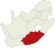
The Eastern Cape interior covers a large area, with its extreme boundaries being the Orange River to the north, the Albany region to the south, the Transkei to the east and the Camdeboo and Central Karoo to the west. Within the area, however, are three distinct regions, namely the Langkloof and Gamtoos Valley, the Eastern Cape Midlands and the Northern Interior, each with their own routes and attractions.
The Eastern Cape interior lies in a transitional zone between the winter and summer rainfall areas (in the west and east, respectively). Most of the precipitation in the non-seasonal area occurs in autumn and spring. The mountainous regions enjoy the highest rainfall and the peaks are often covered in snow in midwinter.
Temperatures rise to the mid-30s in summer, but in winter minimum temperatures can plummet to below freezing point, especially after snow has fallen on the high mountain peaks.
Situated in an area where the Fynbos, Forest, Thicket, Nama Karoo and Grassland biomes meet, the Eastern Cape interior has an extremely rich diversity of flora.
The Fynbos biome reaches the eastern limit of its distribution in the Eastern Cape where the Cape Fold Belt finally runs out. Ericas, proteas, restios (reeds and rushes) and members of the daisy family are characteristic of the mountain fynbos vegetation.
Patches of indigenous forest occur in the Lang-kloof, as well as in the foothills and valleys of the Amathole Mountains (a Xhosa name meaning ‘the calves of the Drakensberg’) and the Katberge. Other valley flora in the region include dense thickets of evergreen and succulent trees and shrubs, grasses and herbs. Common plants are the spekboom (‘pork bush’, a favourite food of elephants), noorsdoring (euphorbias), aloes and thorny shrubs.
The Lower Karoo plains, north of the mountains of the Cape Fold Belt, are dominated by dwarf shrubs and succulent plants. After good summer rains the plains are transformed into waving grasslands. Mixed grasslands are characteristic of the Upper Karoo plains, while sour grasslands occur in the foothills of the Eastern Cape Drakensberg.
The region’s bird life is as diverse as its flora, and birding is extremely rewarding. Cape parrot, lammergeier and high-altitude grassland endemics such as the Drakensberg rock-jumper and Drakensberg siskin are among the noteworthy species.
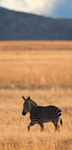
Huge herds of game roamed the plains of the Eastern Cape interior until the arrival of the trekboers with their guns. Antelope were hunted for their meat and hides as well as for sport, while large mammals like elephants were shot for their ivory and to protect crops. Predators, frequently considered vermin, were extinguished mercilessly to protect livestock. It did not take long before the great herds were wiped out – by 1937 the Cape mountain zebra was on the brink of extinction, while the number of Addo elephants – the only population of free-ranging elephants in the Eastern Cape – had been reduced to a mere 11.
ABOVE: The peaks of the Tsitsikamma and Kouga mountains rise above the tranquil Langkloof Valley, which stretches from Herold to Joubertina.
ABOVE: The fertile Gamtoos Valley is a major producer of citrus fruit; vegetables, tobacco and avocados are also grown here.
ABOVE: Baviaanskloof is an unspoilt wilderness bounded by the rugged Baviaanskloof and Kouga mountains.
Rock paintings in overhangs in the Southern Drakensberg and elsewhere in the region are reminders of the San hunter-gatherers who inhabited the region for thousands of years before the arrival of new groups of people – Khoekhoe and Xhosa pastoralists, as well as Dutch pioneers.
In 1689, just 37 years after the establishment of a Dutch settlement at the Cape, Ensign Isaq Schrijver explored the Langkloof Valley between the Tsitsikamma and Kouga mountains. Other explorers, hunters and Dutch trekboers followed in his footsteps and the second half of the 1700s saw the rapid eastward expansion of the Cape Colony’s borders. The Gamtoos River was declared the eastern boundary in 1770, but as the colony expanded the boundary was moved east to the Great Fish River 25 years later.
As the conflict over land and grazing intensified, the eastern frontier increasingly became a violent and volatile place. Between 1779 and 1879 nine frontier wars were fought, during which colonial boundaries were redrawn, alliances were formed between the Xhosa and the Khoekhoen, and some Xhosa groups collaborated with the British authorities while others continued to resist encroachment by the colonialists. Although there were various causes of the nine wars, the struggle for land, grazing rights and stock thefts featured prominently. Other causes included leadership feuds between rival Xhosa chiefs, attacks on rival clans and the expulsion of Xhosa groups from areas they had occupied. It was a restless frontier where war dragged on for up to four years at a time, with the longest period of relative peace lasting for 24 years between the Eighth (1850–53) and the Ninth (1877–79) wars.
The Langkloof (‘long ravine’) stretches from Herold in the Western Cape for 160 km to just east of Joubertina in the Eastern Cape. It is one of the country’s major producers of apples, peaches and pears; dairy farming and timber are other important activities.
The Gamtoos Valley is situated just east of the Langkloof and includes the towns of Loerie, Hankey and Patensie. Blessed with an abundance of water and fertile soil, its agriculture centres on the production of citrus fruit, potatoes, vegetables, tobacco and lucerne.
Uniondale, just outside the Langkloof, was founded in 1865 when two rival villages, Hope-dale and Lyon, were amalgamated. Beautiful Victorian and Edwardian buildings line the streets of this tranquil rural town, which is a centre for the surrounding sheep, goat and deciduous fruit farms. Stewart’s water mill (built in 1852 and now housing a restaurant), the neo-Gothic Dutch Reformed church, the old Congregational church complex and the All Saints church are among the town’s architectural treasures. There is also a factory manufacturing aloe products, and a hitchhiking ghost that is said to haunt the road.
Avontuur is the northern gateway to Prince Alfred’s Pass, which links the Langkloof to the coast. The settlement grew around the farm D’Avontuur (‘the adventure’), granted to Matthys Zondagh in 1765. It is the western terminus of the Port Elizabeth–Avontuur narrow-gauge railway line.
The tiny village of Haarlem with its whitewashed houses and orchards was laid out as a township for the rural community of the Langkloof in 1856, but developed around the mission station established by the Berlin Missionary Society in 1860. The historic church, dating back to 1870, is one of only a few in South Africa built in the shape of a Greek crucifix.
Joubertina, the largest town in the Langkloof, was established on the banks of the Wabooms River as a centre for the Dutch Reformed community in 1907. It is a hub for the honeybush (heuningbos) tea industry – a drink made from the leaves of a small shrub that grows wild on the mountain slopes in the area.
Kareedouw, at the eastern entrance to the Lang-kloof, lies just 8 km off the N2. Indigenous forests of stinkwood and yellowwood grew in the valley when the first farmers settled in the area and the Forester’s Statue is a reminder of Kareedouw’s origins. Exquisite stinkwood, yellowwood and blackwood furniture has been manufactured in the town since 1945, and can be bought on site or made to order. The dressed sandstone Dutch Reformed church dates back to 1905.
Humansdorp is a centre for the surrounding oat, sheep, wool, dairy and citrus farms. The Humansdorp Museum with its displays of farming implements, household articles and historic photographs is well worth a visit, and the Kouga Cultural Centre provides a fascinating insight into the symbolism and meaning of African architecture. Four main themes are depicted: ‘Birth of the African Renaissance’, ‘Mother, Ancestral Mother, Mother Earth’, ‘Peace and Togetherness’ and ‘Hope for the Future’. The centre with its dome-shaped roof was largely constructed from clay, timber poles and thatch from the region. Other attractions include the Humansdorp Park, which was laid out in the form of the Union Jack, and a watermill built in 1847.
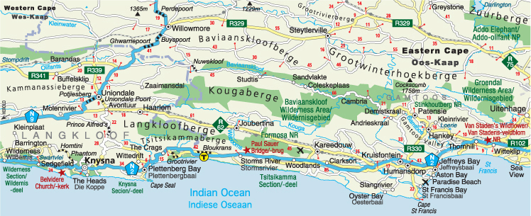
ABOVE: A neat, colourful little garden outside a whitewashed cottage is set against the backdrop of the bare cliffs of the Baviaanskloof.
The tranquil village of Loerie most likely owes its name to the abundance of Knysna loerie (the Afrikaans name for the lourie, now called Knysna turaco) that occurred in the area when the first farmers settled here. Loerie Dam, one of Port Elizabeth’s water-storage reservoirs, is a popular angling and boating spot. The limestone terminus is a reminder of the days when limestone was transported to the station along an 8-km-long overhead cableway. Two men could turn a 60-tonne locomotive on the turntable at the station through 180 degrees.
Hankey, the oldest town in the Gamtoos Valley, developed around a mission station established by the London Missionary Society in 1822. The church, built in 1850, and the graves of the first missionaries are reminders of the town’s origins. The 270-m-long William Philips Irrigation Tunnel, built between 1842 and 1844 to irrigate land in a wide horseshoe bend of the Gamtoos River, was the first irrigation tunnel in South Africa. Another interesting feature is the sundial at the foot of Vergaderingskop. With a diameter of 36,4 m it is the largest in the Southern Hemisphere.
Colourful bougainvilleas, poinsettias and neatly tended gardens fringe the road between Hankey and Patensie. Citrus fruit, vegetables, tobacco, avocados, as well as Patensie’s renowned potatoes are cultivated in the valley. Patensie is the terminus of a branch line coming off the Port Elizabeth–Avontuur narrow-gauge railway. A profile resembling the former British monarch, Queen Victoria, can be seen on a cliff face about 16 km west of the town.
The Uitenhage district was declared in 1804, but the town was only established two years later when the first landdrost (magistrate) was appointed. The stately Cape Dutch-style drostdy (magistrate’s residence), built as the administrative and judicial seat of the Uitenhage district, was completed in 1810. It now forms part of the Uitenhage Historical Museum Complex together with the Old Railway Museum and the 1814 Cuyler Manor.
Uitenhage is an important centre for the automotive industry and is home to Volkswagen South Africa, as well as tyre and car-component manufacturers. The Volkswagen factory tour includes a guided walk through the production line and the AutoPavilion. This fascinating exhibition, with its graphic displays, interactive exhibitions and its unique collection of cars, is the first of its kind in Africa and one of only five such centres in the world.
Proclaimed in 1931 to protect the dwindling elephant population of the Eastern Cape, the Addo Elephant National Park now stretches from Darlington Dam and the Zuurberg Mountains to the Indian Ocean.
The Big Five (elephant, rhino, buffalo, lion and leopard) are the major draw card of the Main Camp game-viewing area where spotted hyaena, kudu, plains zebra, Cape grysbok, warthog, vervet monkey and a host of smaller mammals can also be seen. It is the first ‘Big Seven’ park in the world, as the marine section of the reserve is a sanctuary for the southern right whale (a seasonal visitor) and the great white shark.
With habitats ranging from mountains and succulent thickets to indigenous forest and ocean, Addo offers excellent birding opportunities. To date over 400 bird species have been recorded.
Activities include self-drive game viewing, guided game drives, morning or afternoon horse trails, overnight hikes and day walks. Accommodation options range from campsites, safari tents, forest cabins, rondavels and chalets (all self-catering) to privately owned luxury lodges in concession areas in the park.
Amenities in the Addo Main Camp include a restaurant, shop, filling station, swimming pool, bird hide and an underground hide overlooking a waterhole that is floodlit at night.
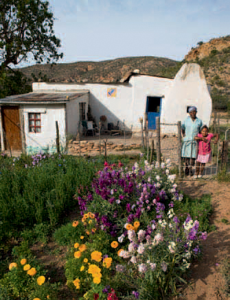
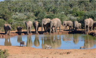
ABOVE: Big and small game are attracted to the waterholes in the Addo Elephant National Park – from elephant to warthog.
Fort Beaufort, the oldest town east of the Great Fish River, was established as a military post along the Kat River in 1822 by the British government at the Cape, and played an important role in the defence of the eastern frontier.
Following the Sixth Xhosa War (1834–35) the settlement was heavily fortified. The fort included infantry barracks, a guardhouse and a military hospital. Work on the landmark Martello Tower, a massive dressed-stone circular tower, began in 1837 and was completed about six years later.
The Seventh Xhosa War (1846–47) was sparked when an axe was stolen from the general-dealer store (now the Emgwenyeni Flats). The suspect was sent to Grahamstown under escort, but managed to escape when Xhosa warriors ambushed the group and cut off the hand of the Khoekhoe prisoner to which the suspect had been handcuffed.
The best way to discover the town’s turbulent history is to follow the Golden Walkway, a trail that starts at the museum. The museum is housed in the former British officers’ mess, built in the 1830s.
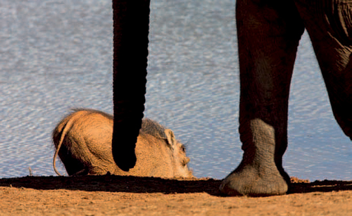
ABOVE: Fort Beaufort’s Martello Tower is one of only two inland fortifications of its kind in the world.
Laid out on the banks on the Tyhume River, the town of Alice was named after the second daughter of Queen Victoria. It is dominated by the University of Fort Hare, which was built in the grounds of an 1846 fort of the same name.
The United Free Church of Scotland established the South African Native College here in 1916. Its status was raised to that of a university college in 1923. Nelson Mandela (South Africa’s first democratically elected president), Oliver Tambo (founding member of the African National Congress Youth League and ANC leader in exile) and Govan Mbeki (ANC leader who was imprisoned along with Mandela, and father of Thabo Mbeki) are among Fort Hare’s numerous distinguished alumni.
An important collection of documents and records of the liberation struggle are preserved in the university’s archive, while the De Beers Centenary Gallery houses an extensive collection of African art. More than 7000 items from different cultural groups in South Africa are displayed in the FS Malan Ethnological Museum.
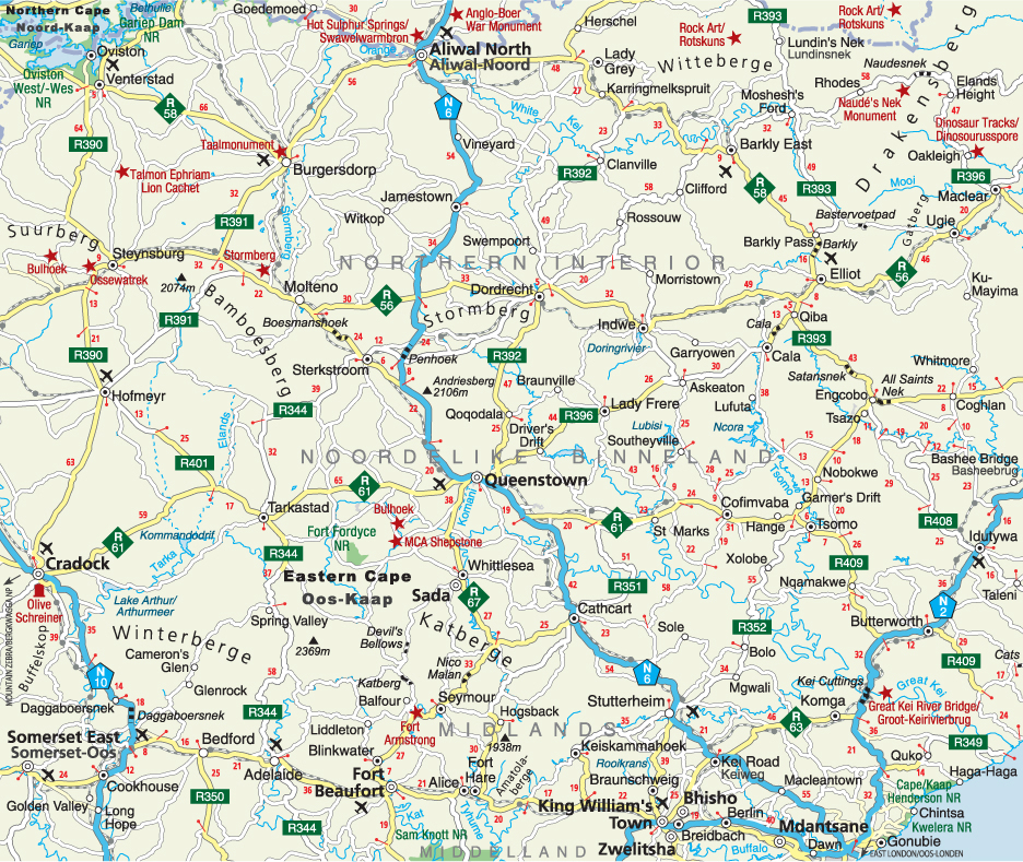
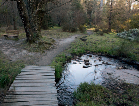
Situated in the heart of the Amathole Mountains amid indigenous forests and pine plantations, Hogsback is reminiscent of an English village. It is renowned for its carefully tended gardens, which are especially attractive in spring when the rhododendrons, azaleas, silver birches and fruit trees begin to bloom. Many artists live in the area, and their arts and crafts range from paintings, pottery and glassware to wrought-iron work, candles and carpentry.
Trails and walks lead to waterfalls with alluring names such as Madonna and Child, Swallowtail, The 39 Steps and the Kettlespout. Energetic visitors can tackle the more demanding trail to the Hogsback Peaks or set off on overnight hikes.
One of the largest trees in the Eastern Cape, the eastern monarch grows in the Auckland Nature Reserve. The centuries-old Outeniqua yellowwood has a height of 38 m and a diameter of 2,71 m.
St Patrick’s on the Hill, one of the smallest houses of worship in the country, the Voice of the Earth Eco-shrine and the 11-circuit Labyrinth at the Edge Mountain Retreat are among the other attractions to be explored.
ABOVE: Fairytale scenes await walkers in the Hogsback forests.
ABOVE: A memorial in King William’s Town honours those who died in World War I (1914–18).
King William’s Town was established on the banks of the Buffalo River as the administrative seat of the Province of Queen Adelaide in 1835. But due to mismanagement, just seven months later the proclamation was repealed and the territory was returned to the Xhosa.
British forces re-occupied the area after the outbreak of the Seventh Xhosa War and British Kaffraria was proclaimed on 17 December 1847, with King William’s Town as its capital.
Founded in 1884, the Amathole Museum is the third-oldest museum in South Africa and its collection of mounted African mammals is the second largest in the country. One of its most famous exhibits is Huberta, the wandering hippo who undertook an epic journey along the coast from Zululand to the Keiskamma River from 1928–31.
Also of interest are the unique displays on the 1856–57 Cattle-Killing Movement (the only one of its kind in the country) and the Xhosa Gallery. A memorial on an open piece of ground in the Edward Street Cemetery marks the site of the mass grave for victims of the Great Cattle Killings.
The South African Missionary Museum, a satellite of the Amathole Museum, is housed in the old Wesleyan church built in 1855. Displays portray various aspects of missionary life in the Eastern Cape.
The Steve Biko Garden of Remembrance in Ginsberg, a township on the outskirts of King William’s Town, is named in honour of the man whose fierce opposition to apartheid helped to shape South Africa’s politics. Born in Ginsberg in 1946, Biko was a founder of the South African Students’ Organisation that later grew into the Black Consciousness Movement. He was outlawed by the apartheid government in 1973 and banned from all political and social organisations. Arrested in August of 1977, he died in September of the same year as a result of massive head injuries sustained while in the custody of security force agents.
Bhisho, 3 km northeast of King William’s Town, was established in the 1980s as the ‘capital’ of the Ciskei, a bantustan (homeland for mainly Xhosa-speaking people) created by the apartheid government in 1981. The territory was ‘reintegrated’ into South Africa in 1992 and Bhisho is currently the capital of the Eastern Cape province.
The Bhisho Massacre Memorial commemorates the deaths of protesters shot and killed on 7 September 1992 during a mass demonstration of tens of thousands of people demanding free political activity and the resignation of the Ciskei military leader, Oupa Gqozo. Soldiers of the Ciskei Defence Force opened fire when a breakaway group smashed through a barricade, killing 28 people and injuring more than 200. The memorial is opposite the Bhisho Stadium.
Named after Queen Victoria, Queenstown developed around the military stronghold established on the banks of the Komani River in 1853. The Hexagonal, an open space in the centre of town from where six streets radiate, was designed to give quick access to the perimeter of the settlement.
The Queenstown and Frontier Museum is housed in the old public school dating from 1897. Cultural history exhibits depict the history of the town and the region during the Xhosa Wars. Other attractions include the dressed-sandstone town hall dating back to 1842 and the St Michael and All Angels Anglican church, inaugurated in 1883.
Cradock grew around the military garrison established on the eastern banks of the Great Fish River in 1813, and was named after Sir John Cradock, the British governor at the time.
Taking a stroll down Market Street is like stepping back 150 years. The Tuishuise (‘town-houses’), a row of typical Karoo-style cottages built in the 1840s, have been restored beautifully and now serve as guest houses. Victoria Manor has presided over Market Square for over 150 years, and the landmark dressed-stone Dutch Reformed church on Central Square is a replica of St Martin’s-in-the-Fields in London. Olive Schreiner, author of The Story of an African Farm and many other literary works, moved to Cradock at the age of 12 and lived with her siblings in a typical Karoo cottage in Cross Street from 1868–70. Her personal library, a collection of the books she wrote and exhibitions on her life can be viewed in Schreiner House. Olive was buried on the summit of Buffelskop, 26 km south of Cradock, on 13 August 1921.
The Great Fish River Museum is housed in the Dutch Reformed parsonage, which was completed in 1825. The museum has the history of Cradock as its theme and is arranged in period rooms. A photographic display in the Cradock Four Gallery tells the story of the anti-apartheid activists – Matthew Goniwe, Fort Calata, Sicelo Mhlauli and Sparrow Mkhonto – who were tortured and brutally murdered by apartheid security force agents in June 1985. The Cradock Four, as they became know, had been travelling back from Port Elizabeth at the time of their abduction. The memorial in the Inxuba Yethemba Municipal Park is a tribute to these freedom fighters.
ABOVE: The Garden of Remembrance in Aliwal North is a reminder of the British soldiers killed in the Anglo– Boer War.
ABOVE: Well-preserved Karoo-style cottages dating back to the 1840s line the streets of Cradock.
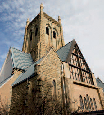
ABOVE: The spire of the Anglican church in Queenstown rises to a height of 49 m.
Cradock Spa, a thermal spring on the banks of the Great Fish River, sports an indoor and outdoor pool. Accommodation is available in self-catering chalets and there is a campsite and picnic facilities for day visitors.
When this park was established in 1937, the Cape mountain zebra was on the brink of extinction. Since then, the species has rallied and the park has been expanded considerably. It is now also home to black rhino and herds of buffalo, gemsbok, black wildebeest, red hartebeest, eland and springbok. Cheetah, grey rhebok and mountain reedbuck also occur in the park, which has a bird checklist of over 200 species.
The area can be explored in a sedan car, but some of the tracks are accessible for four-wheel-drive vehicles only. There are also short walks that can be undertaken.
Accommodation is in self-catering chalets and the Doornhoek Guest House. There is a campsite with hot-water ablutions. Facilities include a restaurant, shop, filling station and a swimming pool. Picnic and braai facilities are provided for day visitors.
ABOVE: The Mountain Zebra National Park was established to save the Cape mountain zebra from becoming extinct.
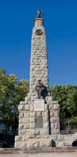
The tranquil country town of Burgersdorp developed around the Dutch Reformed church built on a farm bought in 1846. Burgersdorp became the centre of the campaign to get Dutch recognised as an official language in the late 1870s. The Taalmonument (‘language monument’) commemorates the victory achieved when the use of Dutch in the Cape Parliament was finally allowed in 1882.
The old Reformed church parsonage and the outbuilding of the first theological seminary of the Gereformeerde Kerk (Reformed Church), which broke way from the Nederduitse Gereformeerde Kerk (Dutch Reformed Church) in 1859, are reminders of the role Burgersdorp played in religious matters. The theological school was moved to Potchefstroom in 1905 and later became the University of Potchefstroom, now North-West University.
The history of the town and its environs is portrayed in the Burgersdorp Cultural Historical Museum. There are displays on the Xhosa and the wars fought in the area, as well as collections of clothing, firearms and traditional weapons, wagons and other vehicles.
Aliwal North was established at a drift (ford) on the southern bank of the Orange River in 1849.
The Kerkplein Museum is housed in the Dutch Reformed church, which was consecrated in 1864. It has fascinating reconstructions of the shops and businesses that flourished during the town’s heydays. The old library built in 1876 serves as an extension of the museum.
Other attractions include three blockhouses built around the town by the British in 1901 (during the second Anglo–Boer War) to protect the rail and road bridges across the Orange River and the stone-built tollhouse on the banks of the Orange River. The Concentration Camp Garden is dedicated to the women and children who died in the camps during the second Anglo–Boer War.
The Aliwal Spa, just to the south of the town, has an indoor thermal pool, an outdoor pool, a water slide and a restaurant. Accommodation is available in self-catering chalets and there are campsites.
Nestled in the foothills of the Witteberge (‘white mountains’), Lady Grey was founded in 1866 and named after the wife of the British governor at the Cape, Sir George Grey.
The dressed-sandstone Dutch Reformed church was built on a hillock in the centre of the village in 1913. When the congregation was still struggling to pay off the debts 12 years later, the Koffiehuis (‘coffee house’) was opened to help generate funds. It now serves as a museum on the history of the town and its surroundings.
Barkly East was laid out in 1874 and named after the British governor at the time, Sir Henry Barkly. At an altitude of 1 813 m below the Witteberge, Barkly East is one of the highest and coldest towns in the country. It is a centre for the surrounding merino sheep, stud cattle and dairy farms; wheat, maize and potatoes are also grown in the area.
Prominent among the town’s beautiful dressed-sandstone buildings is the Dutch Reformed church. The old library and municipal building dates back to 1891 and now houses the Barkly East Museum, which has a fascinating collection of traditional Xhosa beadwork, modern Xhosa art, and implements used in sheep and cattle farming.
The railway line, with its system of eight ‘reverses’ which were incorporated to overcome the steep gradients and sharp curves, can be seen just outside the town.
The tiny village of Rhodes, near the southern tip of the Drakensberg, has retained much of its old-world charm. Originally named Ross-ville, it was renamed in 1900 after Cecil John Rhodes. Why the remote village was named after the famous politician and financier is the subject of many tales. One explanation is that Rhodes sent a wagonload of stone pine trees to the village, while another has it that the first 100 plots were sold on condition that the village be named after Rhodes.
Rhodes comes to life in winter when the surrounding mountains are covered in snow. It is also a popular destination with fly-fishing enthusiasts and birders.
ABOVE: Sandstone outcrops and grasslands dominate the landscape near Rhodes.
East of Rhodes, the road climbs steeply to the 2 623-m-high summit of Naudesnek Pass – the highest pass negotiable by a sedan car in South Africa.
The small farming village of Dordrecht was laid out on the northern slopes of Stormberg as a parish of the Dutch Reformed church in 1856. The old part of the town is dominated by the dressed-sandstone Dutch Reformed church with its four clock-faces and imposing spire, and many Victorian houses line the main street.
A room full of photographs of rock-art sites in the area makes a visit to the Anderson Museum worthwhile for rock-art enthusiasts. Furniture and clothing of the late 19th and early 20th centuries and agricultural exhibits are also displayed.
Spectacular sandstone formations in the Drakensberg foothills form a dramatic backdrop to the town of Elliot. North of Elliot, the Barkly Pass winds steeply upwards, and from the 2 012-m-high summit there are magnificent views of the sandstone outcrops, wild valleys and mountain streams far below. Eland, delicately painted grey rhebok and human figures are among the well-preserved rock paintings in the Dinorbin Shelter, a short way beyond the summit of the pass.
Other attractions in the area include Gatberg, a mountain with a hole through its summit, and the Bastervoetpad. This winding gravel road between Barkly Pass and Ugie should only be negotiated in a 4x4 vehicle.
Set amid rolling hills, crystal clear streams and towering mountain peaks, Maclear was established on the banks of the Mooi River following the annexation of the area by the British Administration in 1879. The town was named in honour of the British astronomer, Sir Thomas Maclear, Her Majesty’s Astronomer at the Cape at the time.
The dinosaur tracks on the farm Oakleigh, 17 km from Maclear, are among the earliest evidence of dinosaurs in Southern Africa. The tracks were made by a large, four-legged, plant-eating reptile and a smaller theropod dinosaur that ran on its hind legs. Of special interest is the tail drag of one of the prehistoric creatures.
The area is a paradise for fly fishing, hiking, horse riding.
ACTIVITIES
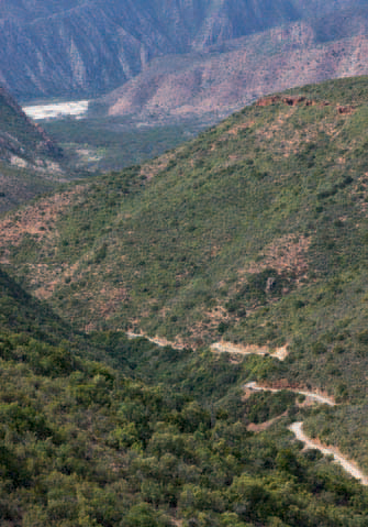
• Mountain biking, hiking, fishing and birdwatching in Baviaanskloof
• Game viewing, birdwatching and flower spotting in the Baviaanskloof Megareserve
• Skiing on the slopes of Ben McDhui at Tiffindell in winter
• Fly fishing in the rivers of the northeast
• Angling and boating at Loerie Dam in Loerie
• Touring the Volkswagen factory in Uitenhage
• Fly fishing, hiking and horse riding at Maclear
• Game viewing, birdwatching, camping, swimming, picnicking and braaing at Addo Elephant and Mountain Zebra national parks
• Camping, picnicking and bathing at the Cradock Spa thermal waters near Cradock
• Camping, braaing and bathing at the Aliwal Spa hot springs in Aliwal North
• Fly fishing and birdwatching at Rhodes
ABOVE: Elephants and warthogs quench their thirst at a waterhole in the Addo Elephant National Park.
ROUTES AND TRAILS
• Heritage and other self-drive routes in Kouga (distance and duration depends on individual itineraries)
• 4x4 Baviaanskloof Route (205 km) from Willowmore to Patensie
• Boskloof Trail (1 hour) in Humansdorp
• Four trails (7 hours–2 days) in the Groendal Wilderness Area near Uitenhage
• Alexandria Hiking Trail (2 days) in Addo Elephant National Park
• Tree Dassie Walk (2–3 hours) in the Addo Elephant National Park
• Two walks (1 and 5 hours) in the Zuurberg in the Addo Elephant National Park
• Two walks (1 and 4 hours) in the Mountain Zebra National Park
• Walks (30 minutes–2 days) in Hogsback
• Two walks (3 hours each) in Pirie Forest near King William’s Town
• Amathole Hiking Trail (2–6 days) from nearby King Williams Town to Hogsback
• Horse trails in Addo Elephant National Park