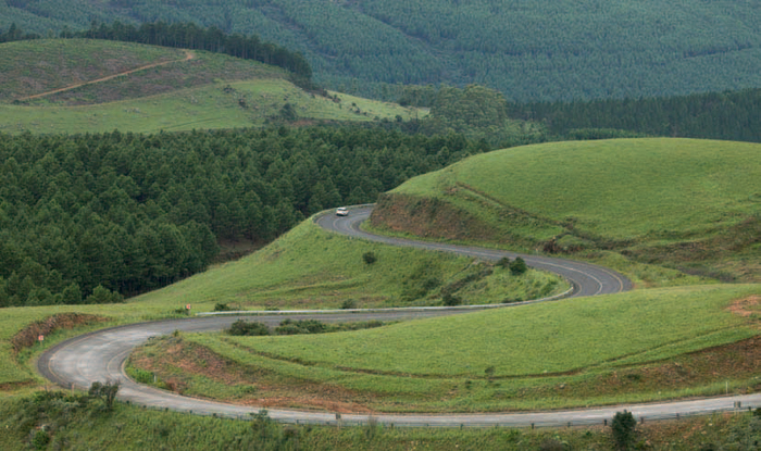
ABOVE: Winding Long Tom Pass makes up part of Mpumalanga’s scenic Panorama Route, one of the country’s finest drives.
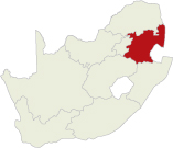
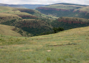
The Mpumalanga Highlands and Great Escarpment is a stretch of the eastern section of the interior plateau on the edge of the Drakensberg. It is here that the land plunges down to meet the Lowveld, a low-lying region that stretches along South Africa’s border with Mozambique. It is cradled by the provinces of Limpopo to the north, Gauteng to the west and KwaZulu-Natal to the southeast. The scenery that accompanies so dramatic a change of territory is equally theatrical, with a full geographical cast that includes rivers, gorges, cliffs, waterfalls and sweeping views. Steep and winding mountain passes show off the scenery to dazzling effect.
A wealth of information on earth’s evolution is contained in the Barberton Greenstone Belt, also known as the ‘Genesis of Life’, located in the Makhonjwa Mountains around Barberton. Here, rocks dating back 3,5 billion years contain fossils that yield not only the secrets of the planet but also gold, a precious metal that has shaped the history of the province.
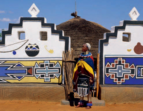
ABOVE: Colourful Ndebele homesteads, with their distinctive geometric patterns, can be seen in the rural areas of the province.
Mpumalanga is said to have two climates, one for its high-lying escarpment and another for its subtropical Lowveld. Temperatures on the escarpment are more extreme with colder, frosty winters and hotter, drier summers. Low-lying areas experience a greater amount of summer rain.
Where the Drakensberg exceeds heights of 2 000 m, alpine grasslands and patches of Afromontane forest can be found. The wetlands that characterise the Highlands, with their high bird and botanical diversity, are a natural treasure.
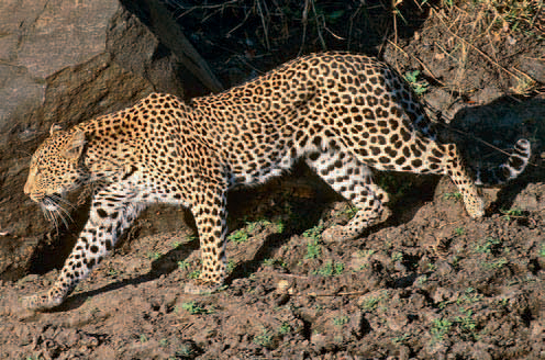
Many species of antelope can be seen, along with predators such as caracal and leopard. Twitchers will find plenty of birds, and three endangered crane species – the blue, wattled and grey-crowned cranes – can all be spotted at the Verloren Vallei Nature Reserve near Dullstroom.
The groups who inhabit this area today – the Shangaan, Swazi and Ndebele – appear to have moved into this region in the 1800s.
The first Voortrekkers, led by Andries Hendrik Potgieter, arrived here in June 1845, founded a village called Andries-Ohrigstad. At about the same time the British annexed Natal, causing the Boers there to trek into the interior, with one group arriving at Andries-Ohrigstad. Clashes between Potgieter and the new arrivals resulted in their moving south to found Lydenburg, while Potgieter took a small commando to the Orange Free State. The Boers that stayed established farming communities and small towns along the Eastern Escarpment.
Located high up in the Drakensberg, eMakhazeni is a popular trout-fishing spot; the town features six well-stocked dams under the supervision of the Belfast Fly Fishing Association. Tulips farmed in the area are another local attraction: an annual festival takes place in September. There is a second Anglo–Boer War (1899–1902) heritage site at Bergendal, a war cemetery and a knife-making studio. Small as eMakhazeni is, it has no less than 12 churches.
One of the earliest white settlements of the old Transvaal, Wakkerstroom is an important birdwatching centre, offering easy sightings of some 40 species endemic to South Africa. Grassland birds are a particular attraction. Off-road and mountain biking as well as horse riding and hikes are some of the less sedentary activities on offer in this quaint village.
The local Opikoppi Private Museum is worth a visit for a general history of the village. The nearby Balele Mountain Lodge has 12 dams for fly fishing. A recommended scenic drive is that between Wakkerstroom and Luneberg. There is a varied choice of accommodation in the area.
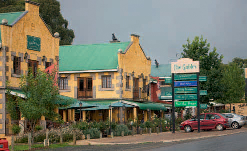
ABOVE: The Gables shopping centre in the heart of Dullstroom is a one-stop location for accommodation, retail shopping and dining.
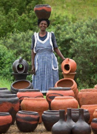
ABOVE: From wooden sculptures to scrap-wire models, intricate beadwork and clay pots, Mpumalanga’s artists fashion all sorts of artistic souvenirs.
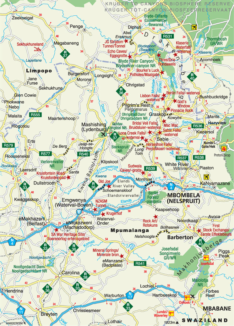
ABOVE: The Kruger to Canyons Biosphere Reserve protects two of the country’s main attractions – Blyde River Canyon and the Kruger National Park, where lucky visitors may spot the shy leopard.
This sheep-farming town may not have much to draw the attention of tourists, but its history is worth a mention for the lofty but unrealised ambition behind its establishment. A Glaswegian, Alexander McCorkindale, dreamt of a New Scotland republic here, in which he planned to settle 300 of his countrymen. He had plans for towns and farms and even went as far as naming a capital city – Roburnia, after Scottish poet Robert Burns. He succeeded in attracting 50 Scots to his new ‘republic’, but died before he could complete his plans. Roburnia became Amsterdam instead, reflecting the old Transvaal’s link with the Netherlands. Farms in the area bear distinctively Scottish names.
Dullstroom, founded in the 1880s by a group of Dutch immigrants headed by a merchant named Wolterus Dull, is renowned as a destination for trout fishing. Local tourism sings the virtues of its five F’s – fly fishing, fireplaces (its high altitude means bracing winters), fauna and flora, fine food and fresh air. There are opportunities for both still-water and river fishing in the vicinity of the town, with brown and rainbow trout the sought-after catches. There are some pretty drives, such as along the Kruisfontein Road, which loops around the town. The Verloren Vallei Nature Reserve, comprising over 30 wetlands, offers some unusual avian and botanical sightings. It is a Ramsar-listed site, and must be visited by arrangement.
eNtokozweni, on the Elands River, originated as a staging post for transport riders on the way to the port at Delagoa Bay (Maputo) in Mozambique, and evolved into a railway town on the completion of a railway line in 1894. This spot is also good fly-fishing and hiking terrain, and a local health resort is known for its thermal sulphur springs.
The 75-m-high Elands River Falls separate these two villages, with Emgwenya (Waterval-Boven) situated above the falls and Waterval-Onder below. Located on the railway track that linked the old Transvaal Republic with Mozambique, the station at Emgwenya commemorates the thousands of labourers who died in the construction of the line, mostly of fever. Attractions include the NZASM Tunnel and a five-arch railway bridge nearby. The Kwena Basin on the outskirts of the village boasts good scenery, nature reserves and fishing lodges, while rock climbing in Emgwenya is reputed to be among the country’s best.
Lydenburg was established in 1849 by a party of Voortrekkers. Nearly 25 years later, in 1873, it experienced an influx of prospectors when alluvial gold was found in the Spekboom (or Dorps) River. Today, mining and agriculture are the lifeblood of the town. Mashishing has one of the oldest Dutch Reformed churches, as well as Anglo–Boer War sites, two nature reserves – Sterkspruit and Gustav Klingbiel – and the spectacular twin Lydenburg Falls.
ABOVE: Although Mashishing had a brief alluvial gold rush, it now thrives on agriculture as well as platinum and chrome mining.
For a few short years, Barberton, founded in the wake of a gold rush in 1884, boomed as fortune-seekers flocked to the small settlement. It was all beer and barmaids, until prospectors left for the promise of greater riches on the Witwatersrand. There are still some active gold mines in Barber-ton, as well as many old buildings that testify to the frenetic early times, such as De Kaap Stock Exchange, Stopforth House and the Lewis and Marks building. Keep an eye out for the statue of the bull terrier Jock, the canine hero of a well-loved South African tale, Sir Percy FitzPatrick’s Jock of the Bushveld. Worth seeing are the cheerful indigenous Barberton Daisy, a disused steam locomotive, and the 20-km aerial cableway that once ferried goods between the town and neighbouring Swaziland. There are also several nature reserves in the area.
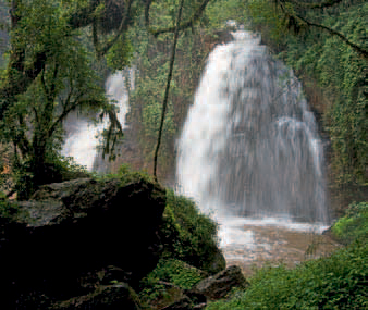
With its extensive pine and blue-gum plantations, Sabie is set in one of the world’s largest man-made forests. A forestry museum tells the story of the timber industry in the region. Set on the Sabie River, which once teemed with crocodiles, the town is famed for the waterfalls in its vicinity, such as the Bridal Veil, Lone Creek, Horseshoe and Sabie falls and the Mac Mac Falls and Pools, where swimming is possible. Hiking is a popular activity in and around the town, with routes ranging in difficulty from easy to gruelling, and there are several adventure activities available, such as abseiling.
ABOVE: The exquisite Horseshoe Falls, so named because of their shape, are located along the Sabie River.
Perched on a spur of the Mauchsberg, Graskop, like other towns in the region, is a one-time gold-mining camp. Drivers making their way from Sabie to the forestry town must stay alert as they climb the steep 11-km incline of the Abel Erasmus Pass, which offers some amazing views. Graskop’s attraction is its convenient location to the scenic wonders of the Blyde River Canyon as well as some awe-inspiring cascades such as the Lisbon and Berlin falls. It is also a good destination for twitchers, with three Important Bird Areas – sites that have been marked for conservation – in the vicinity. Here, some rare bird species, such as Taita and Peregrine falcon, blue swallow and blackwinged plover, can be seen.
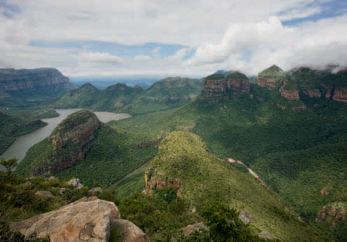
The 20-km long Blyde River Canyon is one of South Africa’s most prized scenic riches. It begins at the confluence of the Motlatse (Blyde) and Sefogane (Treur) rivers and is surrounded by the Blyde River Canyon Nature Reserve, which is rich in fauna and flora. The views are breathtaking: a circular drive beginning at Graskop leads visitors to some of the best viewpoints in the vicinity of the canyon. Must-sees include geological phenomena like the Bourke’s Luck Potholes (cylindrical holes eroded in rocks by whirlpools), the hut-shaped promontories known as the Three Rondavels and the towering Pinnacle Rock. God’s Window, an aptly named viewing point, provides unsurpassed vistas of the Mpumalanga Lowveld. A holiday resort is situated at the impressive Blydepoort (Swadini) Dam.
ABOVE: Mpumalanga’s lush Blyde River Canyon is the world’s largest green canyon.
Pilgrim’s Rest, too, had its beginnings in the feverish gold rush of the 1870s, an all-too-short moment of glory, when ‘Wheelbarrow’ Alex Patterson came upon the first payload of gold in the region. Nowadays, Pilgrim’s Rest is a national heritage site, a well-preserved tribute to this exciting era in South Africa’s history. Its old buildings have been converted into museums, art galleries and arts-and-crafts outlets and the old diggings site has been reconstructed.
GOLD PANNERS LIVE ON
A taste of the wild old gold-rush days can be experienced at the annual South African Open Gold Panning Championships held in Pilgrim’s Rest in September/October. The event is organised by the South African Gold Panning Association, the Pilgrim’s Rest Museum and Mpumalanga’s Department of Culture, Sport and Recreation. Competitors are given a gold pan and a bucket of sand in which gold nuggets are hidden. The winner is the contestant who pans out the most nuggets in the shortest time. Other amusements include a wheelbarrow race, pub crawl and dance.
ABOVE: The historic town of Pilgrim’s Rest is a living museum, reminiscent of the gold-rush days of the 1870s.