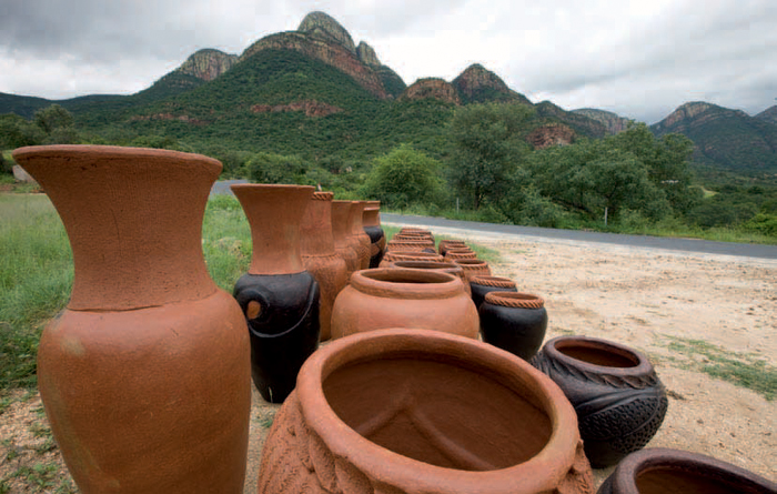
ABOVE: Beautifully crafted Venda pots can be bought in scenic Hoedspruit and along various roadsides in Limpopo province.
The Limpopo Lowveld extends from the town of Tzaneen in the west to the Mozambique border in the east and Hoedspruit in the south, with the Limpopo River forming a natural boundary to the north. Into this region fall the northern reaches of the Kruger National Park and a group of exclusive game lodges in neighbouring protected areas. It is a land of myth and legend, with queens, half-human spirits and reptilian gods to tease the imagination.
In general, Limpopo is hot and dry with high temperatures in the summer – as high as 40 °C in Lowveld towns such as Phalaborwa. In the Kruger National Park summer temperatures hover around the 30 °C mark. Tumultuous thunderstorms accompany the hot weather, while winters are mild. The higher regions of the Soutpansberg are cool, damp and misty.
In the northern part of the Kruger National Park are some species not found in the southern section, including antelope such as Sharpe’s grysbok, Lichtenstein’s hartebeest, roan antelope and the shy suni. This is also the realm of the samango monkey and the yellow-spotted rock dassie. Wild dog are more common here than in the southern region. Rare bird species include Arnot’s chat, the yellow-billed oxpecker, variable sunbird and racket-tailed roller. The Lepelle River, formerly the Olifants River, marks the start of mopane vegetation, a favourite food of elephants.
The baobab tree, so iconic of Africa, becomes a more common sight in the northern parts of the province. The town of Modjadjiskloof is home to the world’s third biggest baobab, which measures over 40 m in circumference.
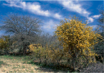
ABOVE: The colourful mopane pomegranate tree is found in the bushveld areas of the Limpopo Lowveld.
The first herders started arriving in southern Africa about 2 000 years ago, bringing with them sheep and cattle. They were followed – between 300 and 400 years later – by Bantu-speaking farmers, skilled in the cultivation of sorghum and millet, the manufacture of pottery and the smelting of iron and copper. Some of these newcomers settled in the hills and valleys south of the Limpopo River, where they lived in small communities, relying on their herds, crop farming and hunting for their survival. Pottery fragments found near places such as Tzaneen and Mashishing, and in the Soutpansberg, have been carbon-dated to between 250 and 450 CE, and the discovery of slag remains suggests that iron was being smelted during this period.
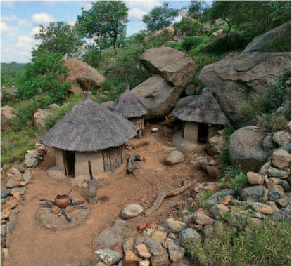
ABOVE: A reconstruction of the Masorini Iron Age site, once inhabited by the baPhalaborwa people, can be seen close to Phalaborwa gate in the Kruger National Park.
From around 900 CE significant economic and political changes, perhaps driven by environmental and climatic conditions, began to take place. Trade became more common as settlements began exchanging goods with people on the Indian Ocean coast. Evidence of early commercial activity along the east coast of Africa includes the remains of glass beads, Chinese porcelain and textiles as well as gold, copper and iron objects found at archaeological sites including Mapungubwe, Schroda and K2 – all Iron Age sites south of the Limpopo River. Notable Later Iron Age sites include Thulamela and Masorini, both located within the Kruger National Park.
Hoedspruit’s advantage lies in its proximity to the Kruger National Park and the privately owned lodges of Timbavati Private Nature Reserve and Klaserie Private Nature Reserve. It has the convenience of an airport too. For those who wish to tarry a while, the secluded Klaserie waterfall is nearby, the Hoedspruit Endangered Species Centre hosts day visitors, and the Khamai Reptile Park, a pioneer in the rehabilitation of snakes, lizards, crocodiles, tortoises, frogs, spiders and scorpions, is open for tours and lectures. The Nyani Tribal Village, which reflects an authentic Shangaan village, is worth a visit. The Blydepoort or Swadini Dam with a range of water-based adventure activities is 35 km away.
It is likely that the baPhalaborwa, also known as the baMalatshi, arrived in the district more than 300 years ago from present-day Zimbabwe. They were metal workers and engaged in the mining of copper and iron ore in the area. The discovery of extensive mine workings in the Phalaborwa region indicates that mining activity started here as long ago as 770 CE. Today the town mines substantial amounts of phosphate and copper. The Foskor Mine Museum offers a history on phosphate mining, while an opencast mine (Phalaborwa’s ‘Big Hole’) can also be toured.
The subtropical climate of the Lowveld is a natural hothouse for crops such as tropical fruit, citrus and nuts, which flourish in Tzaneen. There is also a cheese farm, the Wegraakbosch Organic Cheese Dairy, where visitors can see how cheese is made. On the northeastern boundary of the town the Great Letaba River flows into the Tzaneen Dam, which offers a number of recreational opportunities. The Debegeni Falls are a well-frequented site, the Cheerio Gardens bring you flowering cherry trees in September and October, and the Hans Merensky and Legalameetse nature reserves encourage you to commune with the natural world.
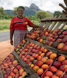
ABOVE: One of the joys of travelling through the Limpopo Lowveld is buying fresh produce along the side of the road. Depending on the season, mangoes, litchis or avocadoes may be found.
ACTIVITIES
• The Magoebaskloof Canopy Tour over Letaba Gorge (2.5 hours) between Tzaneen and Haenertsburg
• Hot-air ballooning at Klaserie Private Nature Reserve in the Greater Kruger National Park
• Golf at the Hans Merensky Country Club in Phalaborwa
• Quad biking, kloofing and tubing in the Magoebaskloof area between Tzaneen and Haenertsburg
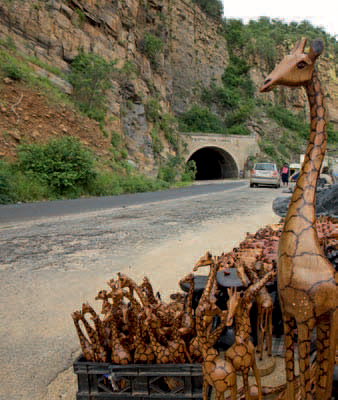
ABOVE: Striking views can be enjoyed from parking lots on either side of the JG Strijdom tunnel, where local hawkers sell their wares.
ROUTES AND TRAILS
• A circular drive (40 km) from Tzaneen along the Great Letaba River, through George’s Valley, across Magoebaskloof Pass and past the mist-covered Wolksberg
• The much-lauded Magoebaskloof Pass road, which drops steeply down from the Great Escarpment to Tzaneen in the Lowveld, bypassing lush cultivated and forested lands
• The 4x4 African Ivory Route (more than 2 000 km) is a superb but rugged self-drive trail through Limpopo, which extends along the western, eastern and northern boundaries of Limpopo and is said to follow the original trail of ivory traders and elephant hunters
• A range of hiking trails from just 4 km to over 60 km (1–6 days), offered by Komatiland Eco-Tourism
• The Louis Changuion hiking trail (up to 1 day) near Haenertsburg, located in a 240-ha stretch of grassland and indigenous forest
• Walking trails (3–4 days), including the Sweni and Olifants trails, in the northern section of the Kruger National Park