ABOVE: Rain in the Kalahari is usually accompanied by violent thunderstorms and spectacular displays of lightning.
The landscape that makes up the vast northwestern corner of South Africa, at the southern edge of the Kalahari, alternates between spectacular red sand dunes, woodlands, gently undulating plains, barren pans and expanses of scenic thornveld.
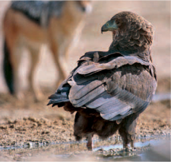
This harsh land is home to the iconic gemsbok (oryx) and other plains antelope, the blackmaned lion of the Kalahari and the pygmy falcon. The bateleur is the undisputed master of the sky, while the huge communal nests of sociable weavers are a characteristic sight on telephone poles and in camel thorn trees.
Bounded by the Orange River Valley in the south, the region shares its western boundary with Namibia. To the north, its boundary is defined by Botswana and the North West Province, and in the east by the Free State. Agriculture centres on cattle, small stock and game farming, but mining is the backbone of the region’s economy. Diamonds played an important role in the development of the area, where immense iron ore, manganese and limestone deposits also occur.
The Kalahari is known for its extremes – in mid-summer, temperatures can soar into the 40s, while winters in the southeast can be freezing cold at well below zero.
Heavy thunderstorms are common in summer, at other times spectacular displays of lightning, are accompanied by short bursts of rain. Precipitation is unpredictable, however, and years can pass without a single drop. When the rains do finally come, an entire year’s quota can fall in a few hours. Average rainfall ranges from 175 mm in the northwest to 500 mm in the east.
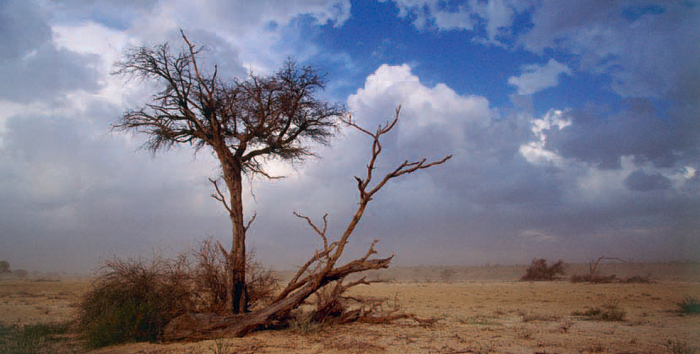
The vegetation varies from open savannah, dominated by acacias and thornveld, to shrub-veld. The camel thorn is the tree most closely associated with the Kalahari. Other characteristic plants include the umbrella thorn, black thorn, shepherd’s tree, silver cluster-leaf, three-thorn rhigozum and raisin-bush.
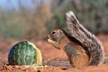
Fields of bright-yellow flowering devil’s thorn are conspicuous after good summer rains when a variety of other flowers and creepers come into bloom. Among them is the tsamma, the desert melon that is an important source of water and nutrition for animals.
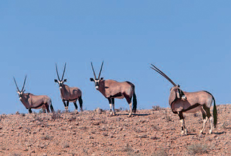
With its rapier horns, the gemsbok has uniquely adapted to survive in this harsh landscape. The plains and dunes of the region were once also home to vast herds of migratory springbok, blue wildebeest, red hartebeest and eland. Lion and other predators were plentiful, but as farmers began settling in the area the wildlife was hunted relentlessly; only those that roamed the most remote parts escaped their guns.
Today, the Kgalagadi Transfrontier Park, which straddles South Africa and Botswana, is sanctuary to a vast array of animals and birds, while several game farms have been stocked with antelope and other game.
The Kalahari is renowned for its raptors and more than 50 species, including 35 residents, have been recorded to date. Summer is the best time for birding when the numbers of resident species are swelled by migrants. The Kalahari Raptor Route map is an excellent guide to raptor viewing along 15 drives in the Kalahari. It is available free from the Northern Cape Tourism Authority and outlines almost 2 000 km of roads in the area.
ABOVE: The bateleur takes its name from the French for tightrope walker – a reference to the way it balances its wings in flight.
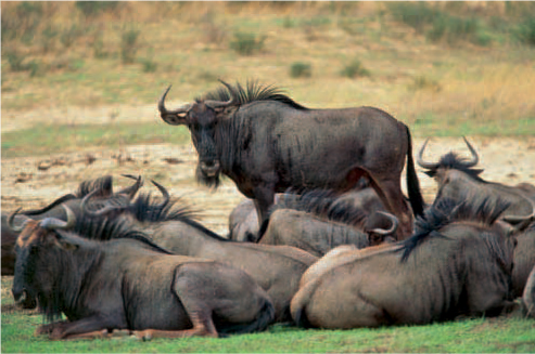
ABOVE: Blue wildebeest are one of the most commonly seen antelope in the Auob and Nossob valleys in the Kgalagadi Transfrontier Park.
The Kalahari is the ancestral home of San hunter-gatherers who lived there for thousands of years; rock engravings at Wildebeest Kuil and elsewhere in the region are testimony to these early inhabitants.
They lived in harmony with nature until the arrival of new groups of people, namely Khoekhoen (black pastoralists), Bantu-speaking Tswanas (who migrated onto the Highveld about 1 000 years ago and practised a mixed economy of cattle-farming and agriculture), Basters (seminomadic pastoralists of mixed Khoekhoe and Dutch descent) and trekboers (white migratory stock farmers).
The Basters arrived in the area known as Transorangia (a territory beyond the Orange River, now known as Griqualand West) in the early 1800s from Little Namaqualand. They settled at fountains around Klaarwater (‘clear water’), renamed Griquatown in 1813, before later spreading out to more distant water sources at Campbell and Daniëlskuil. A new community thus began developing and they adopted the name Griqua in 1813 – after the ChariGuriQua, the Khoekhoe group from which they partly descend.
The lucky discovery of a diamond on the bank of the Orange River near Hopetown in 1866, followed by further, even more promising finds along the banks of the Vaal River in 1869, sparked a diamond rush to the region. While the Griquas and the two independent Boer republics (the South African Republic and the Orange Free State) laid claim to the area, the diggers simply went ahead and declared their own republic in 1870. However, the abundant lands of Griqualand West were annexed by Britain in 1871. That same year, a diamond was found at a hill called Colesberg Kopje, on a farm owned by the De Beers brothers, and so the diamond rush into what would become the town of Kimberley was triggered.
The first mission station north of the Orange River was established at the home base of the Griquas at Klaarwater by the London Missionary Society in 1804. The name was changed to Griquatown in 1813 and the town was laid out in 1879.
ABOVE: A ground squirrel nibbles on a tsamma – an annual creeper with a melon-like fruit that has a moisture content of over 90%.
The Mary Moffat Museum in the main street was named after the eldest daughter of Dr Robert Moffat, who was born in Griqua-town while her missionary father worked here in 1820 and 1821, before the family left for Kuruman. Mary later married the famed explorer Dr David Livingstone. A pulpit, said to have been made by Dr Moffat, and personal items of the Griqua chief Andries Waterboer are among the historic objects in the museum. One of the rooms has been furnished as a bedroom typical of the 1820s, while various documents and articles relating to the town’s history are also displayed.
Other places of interest include the Griqua Monument near the hospital and the Execution Tree. Murderers and stock thieves were sent to hang from the seringa tree when Waterboer had his headquarters here.
The Mokala National Park, 80 km southwest of Kimberley, was officially proclaimed in June 2007 following a successful land claim on a section of the earlier Vaalbos National Park, which was established near Barkly West in 1986.
Within just three months, 860 animals were translocated from Vaalbos to Mokala (a Setswana name for the camel thorn tree), while nearly 390 animals were moved to other parks in the country. Mokala is home to black and white rhino, buffalo, tsessebe, roan, eland, red hartebeest, gemsbok, springbok and plains zebra, as well as various smaller mammals and a rich variety of birds.
Accommodation is available in two lodges, each with a restaurant and conference facilities. There is also a small camp with hot-water ablutions and campsites overlooking a waterhole.
ABOVE: Gemsbok, icons of the Kalahari, are well adapted to survive in arid areas.
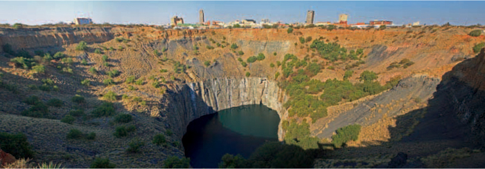
ABOVE: Synonymous with Kimberley is the Big Hole, the largest non-mechanically-dug hole in the world.
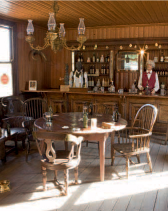
ABOVE: Kimberley’s Old Town gives visitors an idea of what life was like here in the glory days of diamond mining.
Kimberley – the ‘Diamond City’ and the ‘City that Sparkles’ – developed around a mining camp that sprang up after diamonds were found there in 1871.
Miners, fortune-seekers and swindlers rushed to the scene. With picks, shovels and their bare hands, they excavated the largest non-mechanically-dug hole in the world, and called it the Big Hole. When the mine closed in 1914, it covered an area of 17 ha and was 215 m deep. The 22,5 million tonnes of earth that were excavated had yielded 2 722 kg of diamonds.
The Diamonds & Destiny Visitor Centre at the Big Hole provides a fascinating insight into the story of diamonds. A viewing platform suspended over the sheer edge of the Big Hole provides awe-inspiring views of the mine, while a 19th-century mineshaft has been recreated in the Underground Mine. The locally found 616 Diamond and the Eureka, the first diamond found in South Africa (near Hopetown in 1866), are among the treasures on display in the centre’s Diamond Vault.
Adjacent to the Big Hole is Old Town, where period buildings recreate the hectic mining days when fortunes were rapidly made and just as quickly lost. It features a replica of one of the more than 100 pubs that flourished in Kimberley’s heyday, a digger’s house built in 1878, the original Barney Barnato’s Boxing Academy and a pawnbroker’s shop. The oldest church, the German Lutheran Church of St Martini, the oldest house (a prefabricated structure imported from England in 1877), and a diamond buyer’s office are among the many other interesting buildings in Old Town.
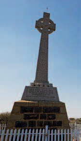
ABOVE: The fallen of the Scottish Highland Regiments are remembered by this Celtic cross.
The early days of transport in Kimberley can be relived by boarding a tram that runs between the City Hall (built in Roman-Corinthian style in 1899) and the Big Hole. The restored tram, Car Number 3, was used between 1906 and 1914.
Situated at the highest point of Kimberley, where five roads converge, the imposing Honoured Dead Memorial commemorates those who died during the 124-day siege of Kimberley during the second Anglo–Boer War of 1899–1902.
Places of interest in Galeshewe, a township in Kimberley that is one of the oldest in the country, include the building where Pan Africanist Congress (PAC) leader Robert Sobukwe had a law office and the Mayibuye Memorial, which honours those who died during the 1952 Kimberley Uprising.
More than 400 engravings have been etched into the rocks on a small hill at Wildebeest Kuil, about 16 km northwest of Kimberley. Eland, rhinoceros, red hartebeest and elephant are among the animals depicted, but unlike other such sites in the Northern Cape there are few engravings of geometric images. A 25-minute-long film introduces visitors to the rock-art site and the !Xun and Khwe San communities of Wildebeest Kuil. Information boards have been erected at engravings along the 800-m-long pathway and visitors can listen to an audio commentary. Facilities at the Wildebeest Kuil Rock Art Centre include displays, an auditorium, arts and crafts shop and a tearoom.
Miners began working the diamond-rich alluvial gravels on both banks of the Vaal River at a fording place call Klipdrift (‘stone ford’) in 1869, and at the height of the diamond-mining frenzy some 20 000 diggers lived in the area. The settlement was named after the governor at the Cape at the time, Sir Henry Barkly, who paid a visit to the diamond fields in 1870.
The first bridge over the Vaal River was opened at Barkly West on 24 June 1885. The old tollhouse on the northern bank of the river now serves as the Barkly West Museum, which focuses on the early diamond diggings. St Mary’s Anglican church, built in 1871, the old jail and the house of Cecil John Rhodes are among the other attractions in the town.
Canteen Kopje, once the site of frantic diamond digging, is also of great archaeological importance. Large numbers of Stone Age artefacts have been uncovered at this hill, among them a 4,7-kg handaxe – one of the largest ever to have been discovered in South Africa.
ABOVE: A few diamond diggers at Barkly West continue to search in the hope of finding the big one.
Daniëlskuil lies in the southern foothills of the Kuruman Hills. It was named after a 6-m-deep limestone sinkhole that somehow reminded the early inhabitants of the biblical story of Daniël and the lions’ den.
Archaeological research at Wonderwerk Cave, a 139-m deep grotto in a dolomite hill 43 km north of Daniëlskuil, has provided evidence of human habitation for the past 800 000 years and early attempts to make fire. Ostrich, eland, elephant and abstract motifs are depicted by the ‘finger paintings’ near the mouth of the cave, where there is also a large stalagmite. Facilities include an information and exhibition centre at the cave entrance and three self-catering cottages.
Situated on the Ghaap Plateau on the edge of the Kalahari, Kuruman is also known as the ‘Oasis of the Kalahari’. It was laid out on the banks of the Kuruman River in 1887 and is a centre for the surrounding farms and mines in the area.
The first mission station of the London Missionary Society for the Tswana people was founded about 90 km north of Kuruman in 1816. It was later moved to Maruping until the Scottish missionary, Dr Robert Moffat, arrived at Kuruman in 1824. Then it was moved once more – to its present site on the western outskirts of Kuruman – and became known as the Kuruman Moffat Mission. The Moffat homestead, wagon shed, the mission church and original water furrow dug by Dr Moffat to irrigate the mission gardens form part of the complex. The foundation stone of the church was laid in 1830 and the 800-seat church was consecrated 3 years later.
The Kalahari Raptor Centre is situated on a 600-ha private nature reserve, 31 km northwest of Kuruman. The centre has aviaries that house raptors that cannot be released back into the wild, as well as an enclosure for vultures. The reserve has been stocked with gemsbok, eland, springbok, red hartebeest, blue wildebeest and plains zebra. There is an education centre and a luxury two-bed self-catering chalet.
Not to be missed is the seemingly endless stream of crystal-clear water that pours out of the dolomite rocks at the Eye of Kuruman, known as Ga-Segonyana (‘little water calabash’) in Setswana.
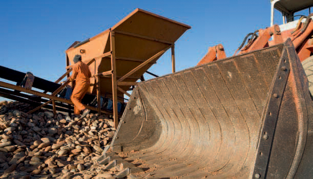
Kathu was established as a mining town for employees of the nearby Sishen Mine in the late 1950s and was laid out amid an exceptionally dense forest of tall camel thorn trees. Covering some 4 000 ha, the camel thorn forest was declared a natural heritage site in 1995.
The Sishen Mine, a few kilometres southwest of Kathu, ranks among the five largest opencast mines in the world and has one of the biggest iron-ore deposits globally. What is more, the iron ore is transported on some of the longest trains in the world along an 800-km-long railway line to the harbour at Saldanha on the West Coast.
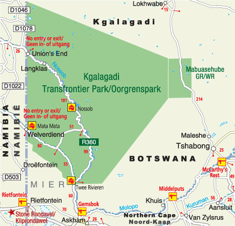
Sandwiched between the Namibian border in the west and the Kgalagadi Transfrontier Park in the north, Mier occupies one of the remotest corners of South Africa.
This almost forgotten piece of land forms part of the ancestral home of the !Khomani San, who were dispossessed of their land in 1930 when the Mier area was declared a settlement for coloured people.
The !Khomani San and those Mier families living north of the settlement were forced to leave that area too, when shortly afterwards, in 1931, the Kalahari Gemsbok National Park was proclaimed.
Rietfontein is the main centre of Mier. The rectangular mission church with its decorative end gables is a reminder of the Baster people who settled here under the leadership of Kaptyn (Captain) Dirk Philander, after migrating from the southwestern Cape in the 1860s.
Years later, in March 1999, Mier made headline news when 25 000 ha of land just outside the Kgalagadi Transfrontier Park were returned to the !Khomani San. The !Khomani San and the Mier community were subsequently also successful in their claims to ownership of land in the southern section of the transfrontier park. This area has been incorporated into the reserve as a contractual park, and the two communities operate a lodge in the area.
The dunes of Mier are ideal for dune boarding and are a challenge to the driving skills of 4x4 enthusiasts.
The Kgalagadi Transfrontier Park is a vast wilderness of red sand dunes, gently undulating sandveld and tree savannahs punctuated by pans and the dry courses of the Nossob and Auob rivers.
One of Africa’s great game parks, it became the first transfrontier conservation area on the continent when South Africa’s Kalahari Gemsbok National Park and Botswana’s Gemsbok National Park were amalgamated in 1999.
It is a sanctuary to large herds of gemsbok, blue wildebeest, red hartebeest, eland, springbok and smaller creatures such as the honey badger, black-backed jackal, bat-eared fox, suricate and ground squirrel. Large predators are represented by the famous black-maned Kalahari lion, leopard, cheetah and brown and spotted hyaena.
Birding is especially rewarding in summer, and bateleur, pygmy falcon, secretarybird, martial eagle, red-necked falcon and six varieties of vulture count among the park’s rich diversity of raptors. Kori bustard, ostrich, Burchell’s sandgrouse, Kalahari scrub-robin, crimson-breasted shrike and sociable weaver are among the conspicuous birds to be ticked.
Accommodation ranges from three rest camps (Twee Rivieren, Mata Mata and Nossob) and tented and wilderness camps in the South African side of the park, to campsites with basic facilities in the Botswana section, which is accessible by four-wheel drive vehicles only.
ACTIVITIES
• Camping and game viewing at Mokala National Park southwest of Kimberley
• Viewing rock art at Wonderwerk Cave, 43 km north of Daniëlskuil, and at Wildebeest Kuil, about 16 km northwest of Kimberley
• Viewing raptors and game at the Kalahari Raptor Centre, 31 km northwest of Kuruman
• Dune boarding and 4x4 driving on the dunes of Mier
• Birding and game viewing at the Kgalagadi Transfrontier Park
• Listening to the Roaring Sand, game viewing, swimming and camping at Witsand Nature Reserve near Postmasburg
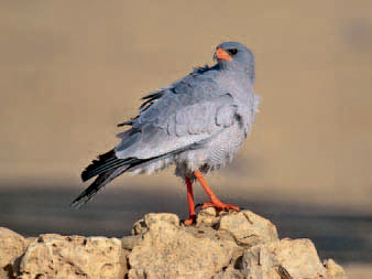
ABOVE: The southern pale chanting goshawk is among the more than 50 raptors occurring in the Kalahari.
• Three 4x4 trails in the South African section of the Kgalagadi Transfrontier Park: Nossob 4x4 Eco Trail (214 km), guided over four days; Bitterpan Trail (120 km), only accessible to residents of Bitterpan Wilderness Camp; and Leeuwdril 4x4 Loop (13,2 km)
• Kalahari Raptor Route entails 15 different routes covering a total 2 000 km in the Northern Cape Kalahari
• Belgravia Walk (2 hours) and Great Kimberley North Walk (4 hours) in Kimberley