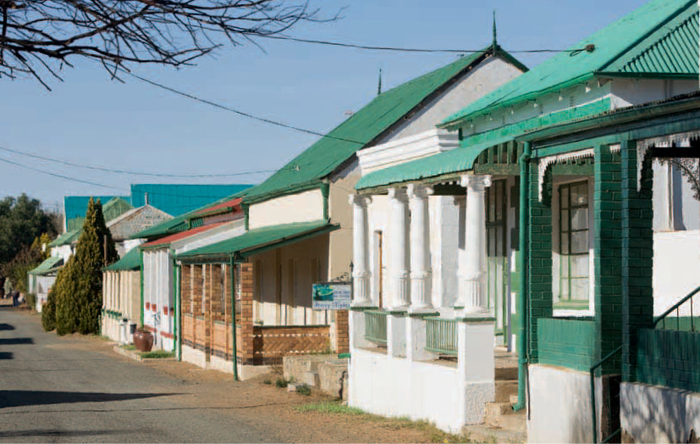
ABOVE: Victorian cottages and flat-roofed Karoo houses line the streets of historic Colesberg.
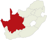
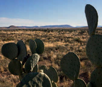
Situated on the South African plateau in the vast expanse of the Great Karoo, the Central Karoo is a tract of land dominated by stony plains punctuated by windmills, the occasional dolerite hill and small mountains.
The Khoekhoen called this vast semi-desert region Kuru, a name meaning ‘hard’ or ‘dry’ – an apt description of this harsh land. The aromatic Karoo bossies (bushes) and grasslands are ideally suited to small-stock farming and the area is a major producer of wool, lamb and mutton.
The region is bounded by the Kalahari and diamond fields in the north, while the Koup and the Camdeboo lie along its southern boundaries. It extends from the Hantam Karoo east to the Eastern Cape Interior and the Orange River.
The climate of the Central Karoo is similar to that of other regions in this semidesert area – extremely hot summers with temperatures exceeding 40 °C, and cold winters. Snowfalls are rare, but frost is common between April and November and temperatures can plunge to -5 °C in midwinter.
The region lies in the summer rainfall area and the rains are accompanied by heavy thunderstorms. Precipitation averages between 200 and 250 mm over much of the region, but increases to more than 400 mm in the north.
A mixture of grassveld and typical Karoo shrubs dominate the vegetation of the region, which lies in an area where the Karoo and the Grassland biomes meet. Grassveld once dominated large areas of the region, but it has been invaded by Karoo plants as a result of overgrazing and poor veld management.
Large herds of springbok, gemsbok, buffalo, elephant, rhino and other game roamed the plains when the first explorers and trekboers (migratory stock farmers) arrived in the region. But it did not take long before the prolific herds disappeared from the vlaktes (plains) and the guns fell silent.
The region lies in the main breeding ground of the lesser kestrel, a Palaearctic migrant from Europe and Asia. The birds begin arriving in November and their numbers peak in January and February.
The region was once home to the !Xam, one of several groups of San hunter-gatherers who occurred throughout much of southern Africa. They lived in small nomadic bands and survived by collecting plants and hunting game with bows and poisoned arrows.
The smooth boulders of the dolerite ridges punctuating the Karoo landscape provided the canvas for San shamans to depict the visions they had under trance. There are numerous rock engraving sites in the region but permission to view them has to be obtained in advance as they are on private land.
The Korana inhabited the region’s northern reaches, moving along the Orange River with their livestock in search of grazing.
Dutch trekboers were already settled widely in the Upper Karoo by the first decade of the 1800s. They needed water to sustain themselves and their livestock and occupied water-holes within the territories of the !Xam. The San struck back by raiding the isolated farms but were powerless against the guns of the trekboers and were soon driven out of the region.
The dominant positions of Dutch Reformed churches in the region suggest that most of the towns were established to serve the spiritual needs of farmers in the surrounding areas.
Hopetown saw a brief flurry of activity after the first diamond was found in the district in 1866. But the miners soon abandoned the town when diamonds were found at Colesberg Kopje and Barkly West.
Nelspoort is usually bypassed by travellers as it is situated off the N1. But for those interested in rock art, a detour will be well rewarded. San hunter-gatherers and Khoekhoe pastoralists left a fascinating legacy of engravings on the dolerite boulders just outside the village.
Engravings of elephant (including one that is 1,2 m long), eland, rhino, ostrich, as well as human figures, animal spoor and geometric patterns abound. Several ‘rock gongs’ (dolerite boulders balanced on top of each other that resonate when struck) can also be seen. Prior arrangements must be made with the custodian of the Restvale Primary School in Nelspoort for a guided tour. It is advisable to wear sturdy footwear and a hat and to take a water bottle along.
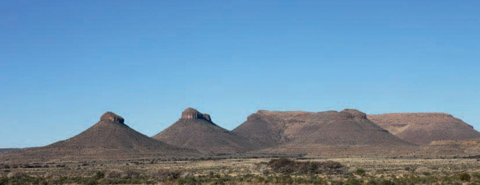
ABOVE: The herds of springbok that once roamed across the Karoo are slowly returning to the plains, which are punctuated by typical Karoo koppies (hillocks).
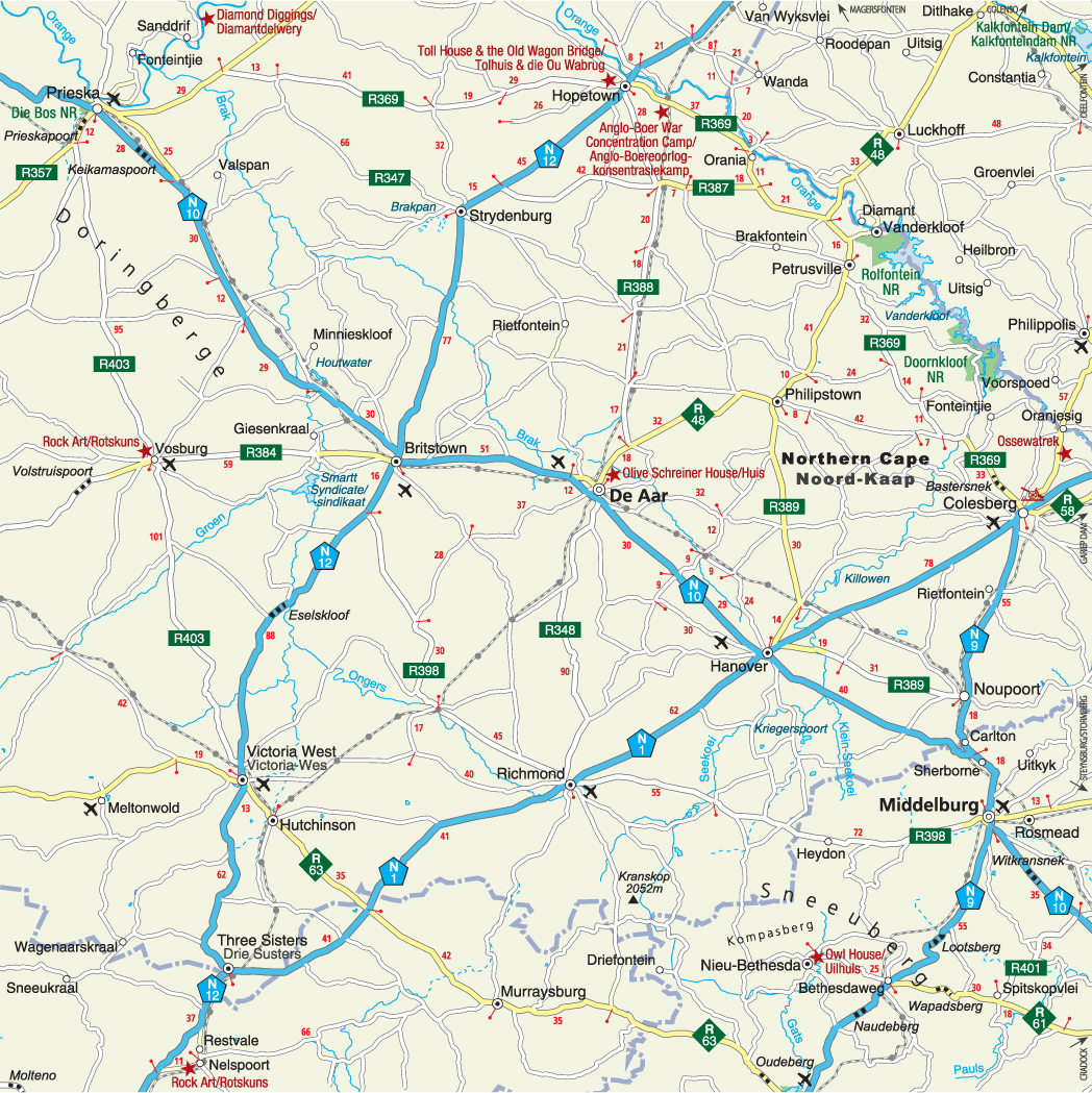
This well-known refuelling stop at the junction of the main routes to Johannesburg via Kimberley and Bloemfontein owes its name to three typical Karoo koppies (hillocks) nearby. The pointed tops of the koppies consist of dolerite. The shales and sandstones immediately below this were baked hard by the heat of the dolerite intrusions, making this layer more resistant to erosion and giving rise to the trademark cliffs of the koppies.
This town was originally called Victoria in honour of the British monarch at the time it was founded in 1844. It was later renamed Victoria West to distinguish it from the Victoria East district which was proclaimed in the Eastern Cape in 1847.
The Victoria West Regional Museum houses displays on the cultural and natural history of the Karoo. A fossil of a prehistoric fish dating back 250 million years is among its fossil collection.
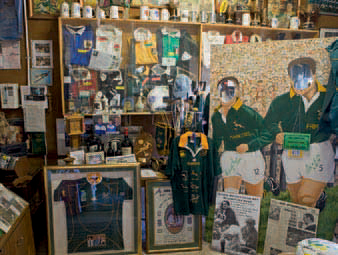
Victoria West is the hometown of Francois du Toit ‘Mannetjies’ Roux, the legendary Springbok rugby player of the 1960s. Rugby fans can visit the Mannetjies Roux Museum at the Victoria Trading Post. Also of interest is the Apollo Theatre, the only remaining 1950s Art Deco cinema in South Africa.
The 1846 Oude Pastorie (‘old parsonage’), the 1869 Anglican church, the 1847 Dutch Reformed church and the Print Shop, where the Victoria West Messenger has been published since 1876, are among the many other historic buildings in the town.
Britstown developed around the settlement established between Victoria West and Kimberley in 1877 to provide accommodation to streams of travellers heading to the diamond fields. Following the discovery of gold on the Witwatersrand, the little settlement thrived, but its fortunes waned when the railway line between Cape Town and Johannesburg bypassed the town.
ABOVE: The Three Sisters, a trio of dolerite-capped Karoo koppies (hillocks), are a familiar landmark for motorists travelling between Cape Town and Johannesburg.
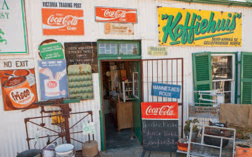
ABOVE: The Victoria Trading Post in Victoria West is a typical general dealer’s store of yesteryear.
ABOVE: Grassy plains and tabletop mountains dominate the landscape around Victoria West.
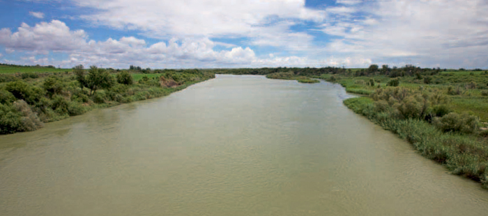
ABOVE: The Orange River flows lazily past Hope-town – once the scene of frantic searches for diamonds.
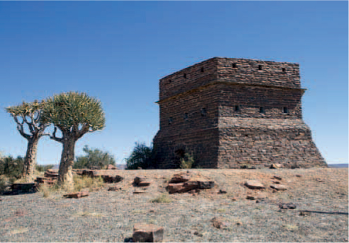
ABOVE: Tiger’s-eye stone was used to build the British military fort at Prieska during the Anglo–Boer War.
The Britstown Museum is housed in the Holy Trinity church, a beautiful dressed-sandstone building with small arched windows. Other attractions include the Dutch Reformed church, built in 1877, and the Smartt Syndicate Dam to the west of town, built in 1964.
Laid out against the backdrop of the Doringberge, Prieska was established at a drift (fording place) on the southern banks of the Orange River in 1882. It is a centre for the surrounding sheep farms and is well known for its semiprecious stones, especially tiger’s-eye.
The Dutch Reformed church, with its unusual spire, was completed in 1878. Prieska Koppie, on the town’s eastern edge, is an ideal vantage point and during the second Anglo–Boer War the British built a stone fort on the hill.
Situated at the confluence of the Prieskapoort and Orange rivers on the northeastern outskirts of the town, Die Bos Nature Reserve is characterised by lush riverine forest and offers good birding possibilities. The Ria Huysamen Aloe Garden in the main street has a fine collection of aloes and other succulents, and is especially attractive when most species are in bloom in July and August.
ABOVE: The cruciform Dutch Reformed church in Strydenburg is the prevailing feature of this small Karoo town.
ABOVE: Olive Schreiner, a famous South African author, lived in this cottage in De Aar from 1907–13.
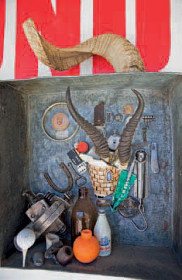
ABOVE: This is ‘All a Karoo Boer needs,’ according to a shop in Richmond.
Founded in 1854 on the southern bank of the Orange River, Hopetown became a hive of activity when a diamond, later named Eureka, was found on the farm De Kalk in 1866. Two letters cut into a windowpane of a building at 33 Church Street are reminders of a simple experiment carried out to establish whether a stone found on the farm Zandfontein in 1869 was a diamond. It was – all 83,5 carats of it. The stone was later named the ‘Star of South Africa’.
The remains of the toll house and the old wagon bridge built across the Orange River in 1875 can be seen about 10 km west of the town.
A disagreement over the location of a new settlement between Britstown and Hopetown caused so much discontent that when the choice fell on the farm Roodepan the town was named Strydenburg (‘town of disagreement’).
Large numbers of flamingos are attracted to Brakpan, a saltpan to the west of town, after good rains.
Unlike most Karoo towns, which were established to serve the religious needs of farmers, De Aar (‘the vein’) developed around the railway junction established here in 1883. Situated almost midway between Cape Town and Johannesburg, its location was also perfect as a junction for the railroads to Port Elizabeth and Upington. The availability of large volumes of water from the strong aar (underground water source), on the farm after which the town was named, also counted in its favour.
The house in Grundling Street where Olive Schreiner lived from 1907–13 is now a restaurant. There is also a small display on the author who is best known for her classic novel, The Story of an African Farm.
Other attractions in the town include the 1894 St Paul’s Anglican church and the Ammunition Museum (the largest ammunition depot in the Southern Hemisphere is at De Aar).
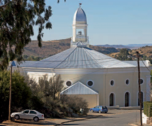
Established in 1843 as a parish for the Dutch Reformed Church, Richmond occupies one of the highest and coldest places of the inland plateau. It was named after the father-in-law of the governor of the Cape at the time, the Duke of Richmond. The Dutch Reformed church was consecrated in 1847, but the tower was only added in 1909. Of special interest is the enormous pulpit, which dates back to 1854.
The area is famous for its horse studs and the Saddle Horse Museum, one of only two in the world, is dedicated to this breed. Housed in the old public school built in 1863, the museum has displays on the American saddle horse and the Anglo–Boer War, as well as rooms decorated in Cape Dutch and Victorian period styles.
Flanked by two koppies, Hanover was laid out on the farm Petrusvallei in 1854. It was named after the German city where the ancestors of Gert Gouws, owner of the farm, were born.
The delightful country town with its water furrows and flat-roofed Karoo houses clustered around the old Market Square has changed little since Olive Schreiner described it as the prettiest village she had ever seen.
Schreiner, one of South Africa’s most celebrated authors, and her husband, Samuel ‘Cron’ Cronwright-Schreiner, lived in Grace Street from 1900–7. Because of her forthright sympathy for the cause of the Boers she was placed under house arrest during the second Anglo–Boer War.
The 1895 Anglican church, magnificent 1895 dressed-sandstone Dutch Reformed church and old library are among the town’s many architectural treasures. The original farmhouse on Petrusvallei has been put to use as the Hanover Museum with displays on the town’s history and development.
A walk up Trappieskop (‘staircase hill’), on the western side of the town, to watch the sunrise or sunset, is rewarded with an all-round view of the surrounding Karoo plains.
Middelburg lies more or less at equal distance from Cradock, Colesberg, Steynsburg and Richmond. It was established as a centre for the Dutch Reformed Church and as a seat of the district’s magistracy in 1852.
The Middelburg Cultural History Museum is housed in a fine Victorian building that dates back to 1898 and was used by the Dutch Reformed Church as a school for underprivileged children. It has exhibits on the second Anglo–Boer War when 10 000 British troops were stationed near the town, San artefacts and traditional Xhosa beadwork. The PW Vorster Museum, on the town’s northern outskirts, is housed in the old gabled homestead built in 1827 on the farm Grootfontein. It focuses on the history and development of the town and has an interesting collection of farming implements.
Noupoort, founded in 1881, owes its name to a narrow valley northwest of the town. The settlement developed around a railway station. The All Souls Anglican church and the British blockhouse on Hospital Hill are interesting historic buildings to visit.
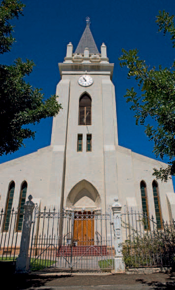
ABOVE: Colesberg’s Dutch Reformed church was built in 1863, but the tower was added later.
Set among Karoo koppies and dolerite boulders, Colesberg lies almost midway between Cape Town and Johannesburg and was once a major staging post on the Great North Road. The town was established in 1830 and owes its name to the British Governor at the Cape at the time, Sir Lowry Cole. The town is a major centre for the surrounding sheep and game farms, but the district is also renowned for its racehorse stud farms.
Colesberg has retained much of its 19th-century charm and typical flat-roofed Karoo houses flank Bell and Stockenstroom streets in the historical heart of the town.
The Colesberg-Kemper Museum is housed in the old Colesberg Bank building that dates back to 1862. It has an interesting collection of fossils, a 19th-century toy collection and photos of the second Anglo–Boer War. Also of interest is the UNISA photographic display on the Karoo donkie-karretjie people – nomads who travel from one place to the next by donkey cart.
Other attractions include the 1840 Trinity Methodist church, the 1854 Anglican church, the 1863 Dutch Reformed church (the clock tower was added in 1926), and the mill in Bell Street – one of the country’s last working horse mills.
Philipstown was established in 1863 and named in honour of the British Governor at the Cape at the time, Sir Philip Wodehouse.
The town’s streets are lined by many fine 19th-century Karoo houses; the magistrate’s court building, the old jail (housing a small museum) and the dressed-sandstone Dutch Reformed church are also of architectural interest.
Situated northeast of Petrusville, the village of Vanderkloof was established in the 1960s to accommodate workers of the Vanderkloof Dam, before being turned into a holiday resort.
The dam forms part of the Orange River Development Project and is the largest man-made lake in South Africa, after the Gariep Dam. The water backs up for 100 km behind the 108-m-high wall, which is the highest in the country and houses a hydroelectric power station.
ACTIVITIES
• Hang-gliding and paragliding in Middelburg, one of the prime sites in the country
• Canoeing and angling on the Orange River
• Game viewing, birdwatching and picnicking at Rolfontein Nature Reserve near Vanderkloof
• Game viewing, birdwatching, camping and picnicking at Doornkloof Nature Reserve near Colesburg
• Water-skiing, windsurfing and other water sports on the Vanderkloof Dam
• Visiting rock engravings on farms in the region
• Viewing ‘rock gongs’ at Nelspoort
• Mountain biking, hiking and 4x4 trails on farms in the region
• Hunting on farms in the region
ABOVE: Memorabilia of Springbok rugby legend ‘Mannetjies’ Roux are on display in Victoria West.
ROUTES AND TRAILS
• Two trails with Trans-Karoo Adventures (5 hours or 2–3 days) on the farm Rietpoort, 26 km from Noupoort
• Pied Barbet Trail (2 hours) in the Rolfontein Nature Reserve near Vanderkloof
• Bokmakierie Trail (3 days) in the Doornkloof Nature Reserve near Colesberg